Boyu Zhou
AirHunt: Bridging VLM Semantics and Continuous Planning for Efficient Aerial Object Navigation
Jan 19, 2026Abstract:Recent advances in large Vision-Language Models (VLMs) have provided rich semantic understanding that empowers drones to search for open-set objects via natural language instructions. However, prior systems struggle to integrate VLMs into practical aerial systems due to orders-of-magnitude frequency mismatch between VLM inference and real-time planning, as well as VLMs' limited 3D scene understanding. They also lack a unified mechanism to balance semantic guidance with motion efficiency in large-scale environments. To address these challenges, we present AirHunt, an aerial object navigation system that efficiently locates open-set objects with zero-shot generalization in outdoor environments by seamlessly fusing VLM semantic reasoning with continuous path planning. AirHunt features a dual-pathway asynchronous architecture that establishes a synergistic interface between VLM reasoning and path planning, enabling continuous flight with adaptive semantic guidance that evolves through motion. Moreover, we propose an active dual-task reasoning module that exploits geometric and semantic redundancy to enable selective VLM querying, and a semantic-geometric coherent planning module that dynamically reconciles semantic priorities and motion efficiency in a unified framework, enabling seamless adaptation to environmental heterogeneity. We evaluate AirHunt across diverse object navigation tasks and environments, demonstrating a higher success rate with lower navigation error and reduced flight time compared to state-of-the-art methods. Real-world experiments further validate AirHunt's practical capability in complex and challenging environments. Code and dataset will be made publicly available before publication.
FlyCo: Foundation Model-Empowered Drones for Autonomous 3D Structure Scanning in Open-World Environments
Jan 12, 2026Abstract:Autonomous 3D scanning of open-world target structures via drones remains challenging despite broad applications. Existing paradigms rely on restrictive assumptions or effortful human priors, limiting practicality, efficiency, and adaptability. Recent foundation models (FMs) offer great potential to bridge this gap. This paper investigates a critical research problem: What system architecture can effectively integrate FM knowledge for this task? We answer it with FlyCo, a principled FM-empowered perception-prediction-planning loop enabling fully autonomous, prompt-driven 3D target scanning in diverse unknown open-world environments. FlyCo directly translates low-effort human prompts (text, visual annotations) into precise adaptive scanning flights via three coordinated stages: (1) perception fuses streaming sensor data with vision-language FMs for robust target grounding and tracking; (2) prediction distills FM knowledge and combines multi-modal cues to infer the partially observed target's complete geometry; (3) planning leverages predictive foresight to generate efficient and safe paths with comprehensive target coverage. Building on this, we further design key components to boost open-world target grounding efficiency and robustness, enhance prediction quality in terms of shape accuracy, zero-shot generalization, and temporal stability, and balance long-horizon flight efficiency with real-time computability and online collision avoidance. Extensive challenging real-world and simulation experiments show FlyCo delivers precise scene understanding, high efficiency, and real-time safety, outperforming existing paradigms with lower human effort and verifying the proposed architecture's practicality. Comprehensive ablations validate each component's contribution. FlyCo also serves as a flexible, extensible blueprint, readily leveraging future FM and robotics advances. Code will be released.
D$^{2}$-VPR: A Parameter-efficient Visual-foundation-model-based Visual Place Recognition Method via Knowledge Distillation and Deformable Aggregation
Nov 16, 2025Abstract:Visual Place Recognition (VPR) aims to determine the geographic location of a query image by retrieving its most visually similar counterpart from a geo-tagged reference database. Recently, the emergence of the powerful visual foundation model, DINOv2, trained in a self-supervised manner on massive datasets, has significantly improved VPR performance. This improvement stems from DINOv2's exceptional feature generalization capabilities but is often accompanied by increased model complexity and computational overhead that impede deployment on resource-constrained devices. To address this challenge, we propose $D^{2}$-VPR, a $D$istillation- and $D$eformable-based framework that retains the strong feature extraction capabilities of visual foundation models while significantly reducing model parameters and achieving a more favorable performance-efficiency trade-off. Specifically, first, we employ a two-stage training strategy that integrates knowledge distillation and fine-tuning. Additionally, we introduce a Distillation Recovery Module (DRM) to better align the feature spaces between the teacher and student models, thereby minimizing knowledge transfer losses to the greatest extent possible. Second, we design a Top-Down-attention-based Deformable Aggregator (TDDA) that leverages global semantic features to dynamically and adaptively adjust the Regions of Interest (ROI) used for aggregation, thereby improving adaptability to irregular structures. Extensive experiments demonstrate that our method achieves competitive performance compared to state-of-the-art approaches. Meanwhile, it reduces the parameter count by approximately 64.2% and FLOPs by about 62.6% (compared to CricaVPR).Code is available at https://github.com/tony19980810/D2VPR.
ApexNav: An Adaptive Exploration Strategy for Zero-Shot Object Navigation with Target-centric Semantic Fusion
Apr 22, 2025


Abstract:Navigating unknown environments to find a target object is a significant challenge. While semantic information is crucial for navigation, relying solely on it for decision-making may not always be efficient, especially in environments with weak semantic cues. Additionally, many methods are susceptible to misdetections, especially in environments with visually similar objects. To address these limitations, we propose ApexNav, a zero-shot object navigation framework that is both more efficient and reliable. For efficiency, ApexNav adaptively utilizes semantic information by analyzing its distribution in the environment, guiding exploration through semantic reasoning when cues are strong, and switching to geometry-based exploration when they are weak. For reliability, we propose a target-centric semantic fusion method that preserves long-term memory of the target object and similar objects, reducing false detections and minimizing task failures. We evaluate ApexNav on the HM3Dv1, HM3Dv2, and MP3D datasets, where it outperforms state-of-the-art methods in both SR and SPL metrics. Comprehensive ablation studies further demonstrate the effectiveness of each module. Furthermore, real-world experiments validate the practicality of ApexNav in physical environments. Project page is available at https://robotics-star.com/ApexNav.
FERMI: Flexible Radio Mapping with a Hybrid Propagation Model and Scalable Autonomous Data Collection
Apr 21, 2025Abstract:Communication is fundamental for multi-robot collaboration, with accurate radio mapping playing a crucial role in predicting signal strength between robots. However, modeling radio signal propagation in large and occluded environments is challenging due to complex interactions between signals and obstacles. Existing methods face two key limitations: they struggle to predict signal strength for transmitter-receiver pairs not present in the training set, while also requiring extensive manual data collection for modeling, making them impractical for large, obstacle-rich scenarios. To overcome these limitations, we propose FERMI, a flexible radio mapping framework. FERMI combines physics-based modeling of direct signal paths with a neural network to capture environmental interactions with radio signals. This hybrid model learns radio signal propagation more efficiently, requiring only sparse training data. Additionally, FERMI introduces a scalable planning method for autonomous data collection using a multi-robot team. By increasing parallelism in data collection and minimizing robot travel costs between regions, overall data collection efficiency is significantly improved. Experiments in both simulation and real-world scenarios demonstrate that FERMI enables accurate signal prediction and generalizes well to unseen positions in complex environments. It also supports fully autonomous data collection and scales to different team sizes, offering a flexible solution for creating radio maps. Our code is open-sourced at https://github.com/ymLuo1214/Flexible-Radio-Mapping.
Perception-aware Planning for Quadrotor Flight in Unknown and Feature-limited Environments
Mar 19, 2025


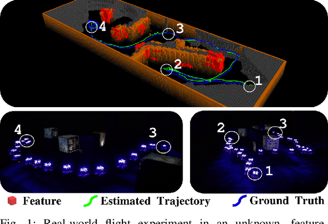
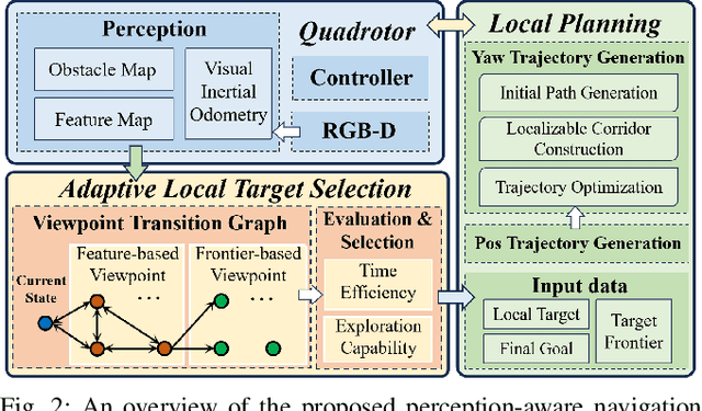
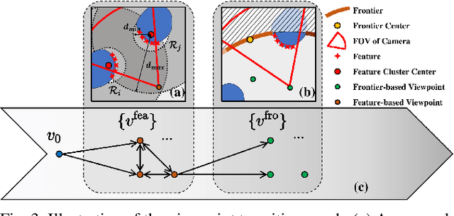
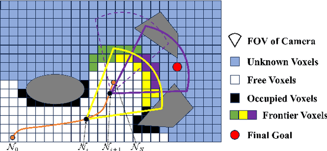
Abstract:Various studies on perception-aware planning have been proposed to enhance the state estimation accuracy of quadrotors in visually degraded environments. However, many existing methods heavily rely on prior environmental knowledge and face significant limitations in previously unknown environments with sparse localization features, which greatly limits their practical application. In this paper, we present a perception-aware planning method for quadrotor flight in unknown and feature-limited environments that properly allocates perception resources among environmental information during navigation. We introduce a viewpoint transition graph that allows for the adaptive selection of local target viewpoints, which guide the quadrotor to efficiently navigate to the goal while maintaining sufficient localizability and without being trapped in feature-limited regions. During the local planning, a novel yaw trajectory generation method that simultaneously considers exploration capability and localizability is presented. It constructs a localizable corridor via feature co-visibility evaluation to ensure localization robustness in a computationally efficient way. Through validations conducted in both simulation and real-world experiments, we demonstrate the feasibility and real-time performance of the proposed method. The source code will be released to benefit the community.
AKF-LIO: LiDAR-Inertial Odometry with Gaussian Map by Adaptive Kalman Filter
Mar 10, 2025Abstract:Existing LiDAR-Inertial Odometry (LIO) systems typically use sensor-specific or environment-dependent measurement covariances during state estimation, leading to laborious parameter tuning and suboptimal performance in challenging conditions (e.g., sensor degeneracy and noisy observations). Therefore, we propose an Adaptive Kalman Filter (AKF) framework that dynamically estimates time-varying noise covariances of LiDAR and Inertial Measurement Unit (IMU) measurements, enabling context-aware confidence weighting between sensors. During LiDAR degeneracy, the system prioritizes IMU data while suppressing contributions from unreliable inputs like moving objects or noisy point clouds. Furthermore, a compact Gaussian-based map representation is introduced to model environmental planarity and spatial noise. A correlated registration strategy ensures accurate plane normal estimation via pseudo-merge, even in unstructured environments like forests. Extensive experiments validate the robustness of the proposed system across diverse environments, including dynamic scenes and geometrically degraded scenarios. Our method achieves reliable localization results across all MARS-LVIG sequences and ranks 8th on the KITTI Odometry Benchmark. The code will be released at https://github.com/xpxie/AKF-LIO.git.
Multi-Robot System for Cooperative Exploration in Unknown Environments: A Survey
Mar 10, 2025Abstract:With the advancement of multi-robot technology, cooperative exploration tasks have garnered increasing attention. This paper presents a comprehensive review of multi-robot cooperative exploration systems. First, we review the evolution of robotic exploration and introduce a modular research framework tailored for multi-robot cooperative exploration. Based on this framework, we systematically categorize and summarize key system components. As a foundational module for multi-robot exploration, the localization and mapping module is primarily introduced by focusing on global and relative pose estimation, as well as multi-robot map merging techniques. The cooperative motion module is further divided into learning-based approaches and multi-stage planning, with the latter encompassing target generation, task allocation, and motion planning strategies. Given the communication constraints of real-world environments, we also analyze the communication module, emphasizing how robots exchange information within local communication ranges and under limited transmission capabilities. Finally, we discuss the challenges and future research directions for multi-robot cooperative exploration in light of real-world trends. This review aims to serve as a valuable reference for researchers and practitioners in the field.
Cooperative Aerial Robot Inspection Challenge: A Benchmark for Heterogeneous Multi-UAV Planning and Lessons Learned
Jan 14, 2025


Abstract:We propose the Cooperative Aerial Robot Inspection Challenge (CARIC), a simulation-based benchmark for motion planning algorithms in heterogeneous multi-UAV systems. CARIC features UAV teams with complementary sensors, realistic constraints, and evaluation metrics prioritizing inspection quality and efficiency. It offers a ready-to-use perception-control software stack and diverse scenarios to support the development and evaluation of task allocation and motion planning algorithms. Competitions using CARIC were held at IEEE CDC 2023 and the IROS 2024 Workshop on Multi-Robot Perception and Navigation, attracting innovative solutions from research teams worldwide. This paper examines the top three teams from CDC 2023, analyzing their exploration, inspection, and task allocation strategies while drawing insights into their performance across scenarios. The results highlight the task's complexity and suggest promising directions for future research in cooperative multi-UAV systems.
Local Reactive Control for Mobile Manipulators with Whole-Body Safety in Complex Environments
Jan 06, 2025


Abstract:Mobile manipulators typically encounter significant challenges in navigating narrow, cluttered environments due to their high-dimensional state spaces and complex kinematics. While reactive methods excel in dynamic settings, they struggle to efficiently incorporate complex, coupled constraints across the entire state space. In this work, we present a novel local reactive controller that reformulates the time-domain single-step problem into a multi-step optimization problem in the spatial domain, leveraging the propagation of a serial kinematic chain. This transformation facilitates the formulation of customized, decoupled link-specific constraints, which is further solved efficiently with augmented Lagrangian differential dynamic programming (AL-DDP). Our approach naturally absorbs spatial kinematic propagation in the forward pass and processes all link-specific constraints simultaneously during the backward pass, enhancing both constraint management and computational efficiency. Notably, in this framework, we formulate collision avoidance constraints for each link using accurate geometric models with extracted free regions, and this improves the maneuverability of the mobile manipulator in narrow, cluttered spaces. Experimental results showcase significant improvements in safety, efficiency, and task completion rates. These findings underscore the robustness of the proposed method, particularly in narrow, cluttered environments where conventional approaches could falter. The open-source project can be found at https://github.com/Chunx1nZHENG/MM-with-Whole-Body-Safety-Release.git.
 Add to Chrome
 Add to Firefox
 Add to Edge