Hongyuan Wang
Step 3.5 Flash: Open Frontier-Level Intelligence with 11B Active Parameters
Feb 11, 2026Abstract:We introduce Step 3.5 Flash, a sparse Mixture-of-Experts (MoE) model that bridges frontier-level agentic intelligence and computational efficiency. We focus on what matters most when building agents: sharp reasoning and fast, reliable execution. Step 3.5 Flash pairs a 196B-parameter foundation with 11B active parameters for efficient inference. It is optimized with interleaved 3:1 sliding-window/full attention and Multi-Token Prediction (MTP-3) to reduce the latency and cost of multi-round agentic interactions. To reach frontier-level intelligence, we design a scalable reinforcement learning framework that combines verifiable signals with preference feedback, while remaining stable under large-scale off-policy training, enabling consistent self-improvement across mathematics, code, and tool use. Step 3.5 Flash demonstrates strong performance across agent, coding, and math tasks, achieving 85.4% on IMO-AnswerBench, 86.4% on LiveCodeBench-v6 (2024.08-2025.05), 88.2% on tau2-Bench, 69.0% on BrowseComp (with context management), and 51.0% on Terminal-Bench 2.0, comparable to frontier models such as GPT-5.2 xHigh and Gemini 3.0 Pro. By redefining the efficiency frontier, Step 3.5 Flash provides a high-density foundation for deploying sophisticated agents in real-world industrial environments.
Step-DeepResearch Technical Report
Dec 24, 2025Abstract:As LLMs shift toward autonomous agents, Deep Research has emerged as a pivotal metric. However, existing academic benchmarks like BrowseComp often fail to meet real-world demands for open-ended research, which requires robust skills in intent recognition, long-horizon decision-making, and cross-source verification. To address this, we introduce Step-DeepResearch, a cost-effective, end-to-end agent. We propose a Data Synthesis Strategy Based on Atomic Capabilities to reinforce planning and report writing, combined with a progressive training path from agentic mid-training to SFT and RL. Enhanced by a Checklist-style Judger, this approach significantly improves robustness. Furthermore, to bridge the evaluation gap in the Chinese domain, we establish ADR-Bench for realistic deep research scenarios. Experimental results show that Step-DeepResearch (32B) scores 61.4% on Scale AI Research Rubrics. On ADR-Bench, it significantly outperforms comparable models and rivals SOTA closed-source models like OpenAI and Gemini DeepResearch. These findings prove that refined training enables medium-sized models to achieve expert-level capabilities at industry-leading cost-efficiency.
Step-Audio-AQAA: a Fully End-to-End Expressive Large Audio Language Model
Jun 10, 2025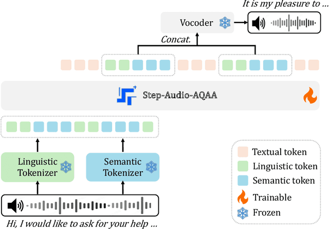
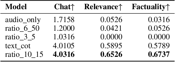
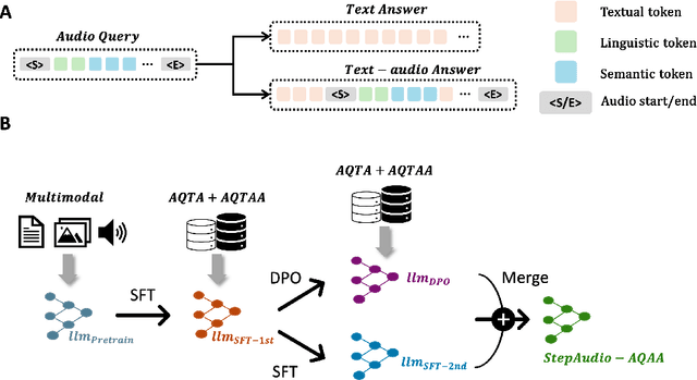

Abstract:Large Audio-Language Models (LALMs) have significantly advanced intelligent human-computer interaction, yet their reliance on text-based outputs limits their ability to generate natural speech responses directly, hindering seamless audio interactions. To address this, we introduce Step-Audio-AQAA, a fully end-to-end LALM designed for Audio Query-Audio Answer (AQAA) tasks. The model integrates a dual-codebook audio tokenizer for linguistic and semantic feature extraction, a 130-billion-parameter backbone LLM and a neural vocoder for high-fidelity speech synthesis. Our post-training approach employs interleaved token-output of text and audio to enhance semantic coherence and combines Direct Preference Optimization (DPO) with model merge to improve performance. Evaluations on the StepEval-Audio-360 benchmark demonstrate that Step-Audio-AQAA excels especially in speech control, outperforming the state-of-art LALMs in key areas. This work contributes a promising solution for end-to-end LALMs and highlights the critical role of token-based vocoder in enhancing overall performance for AQAA tasks.
ViStoryBench: Comprehensive Benchmark Suite for Story Visualization
May 30, 2025Abstract:Story visualization, which aims to generate a sequence of visually coherent images aligning with a given narrative and reference images, has seen significant progress with recent advancements in generative models. To further enhance the performance of story visualization frameworks in real-world scenarios, we introduce a comprehensive evaluation benchmark, ViStoryBench. We collect a diverse dataset encompassing various story types and artistic styles, ensuring models are evaluated across multiple dimensions such as different plots (e.g., comedy, horror) and visual aesthetics (e.g., anime, 3D renderings). ViStoryBench is carefully curated to balance narrative structures and visual elements, featuring stories with single and multiple protagonists to test models' ability to maintain character consistency. Additionally, it includes complex plots and intricate world-building to challenge models in generating accurate visuals. To ensure comprehensive comparisons, our benchmark incorporates a wide range of evaluation metrics assessing critical aspects. This structured and multifaceted framework enables researchers to thoroughly identify both the strengths and weaknesses of different models, fostering targeted improvements.
Step-Audio: Unified Understanding and Generation in Intelligent Speech Interaction
Feb 18, 2025Abstract:Real-time speech interaction, serving as a fundamental interface for human-machine collaboration, holds immense potential. However, current open-source models face limitations such as high costs in voice data collection, weakness in dynamic control, and limited intelligence. To address these challenges, this paper introduces Step-Audio, the first production-ready open-source solution. Key contributions include: 1) a 130B-parameter unified speech-text multi-modal model that achieves unified understanding and generation, with the Step-Audio-Chat version open-sourced; 2) a generative speech data engine that establishes an affordable voice cloning framework and produces the open-sourced lightweight Step-Audio-TTS-3B model through distillation; 3) an instruction-driven fine control system enabling dynamic adjustments across dialects, emotions, singing, and RAP; 4) an enhanced cognitive architecture augmented with tool calling and role-playing abilities to manage complex tasks effectively. Based on our new StepEval-Audio-360 evaluation benchmark, Step-Audio achieves state-of-the-art performance in human evaluations, especially in terms of instruction following. On open-source benchmarks like LLaMA Question, shows 9.3% average performance improvement, demonstrating our commitment to advancing the development of open-source multi-modal language technologies. Our code and models are available at https://github.com/stepfun-ai/Step-Audio.
Complementary Advantages: Exploiting Cross-Field Frequency Correlation for NIR-Assisted Image Denoising
Dec 21, 2024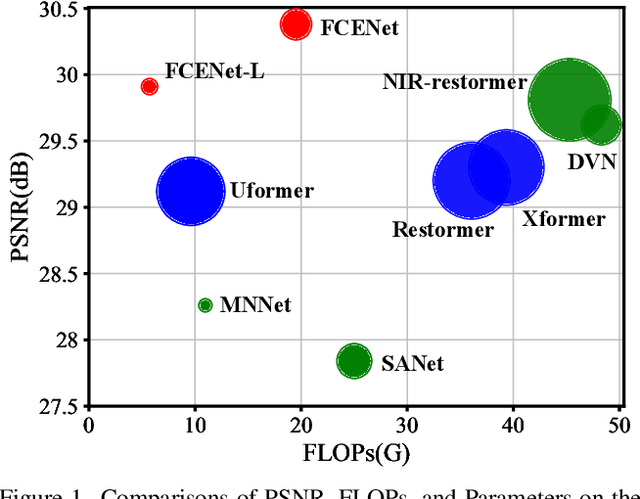
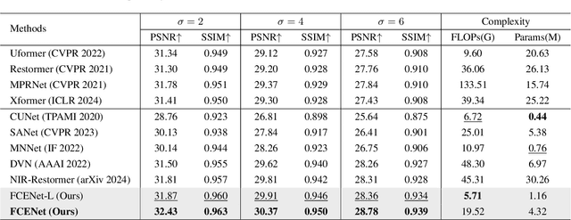
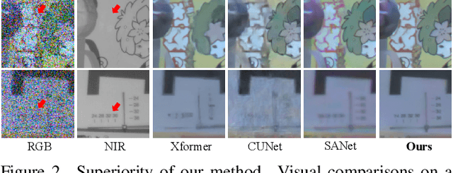
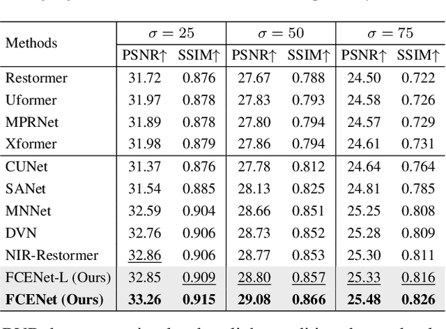
Abstract:Existing single-image denoising algorithms often struggle to restore details when dealing with complex noisy images. The introduction of near-infrared (NIR) images offers new possibilities for RGB image denoising. However, due to the inconsistency between NIR and RGB images, the existing works still struggle to balance the contributions of two fields in the process of image fusion. In response to this, in this paper, we develop a cross-field Frequency Correlation Exploiting Network (FCENet) for NIR-assisted image denoising. We first propose the frequency correlation prior based on an in-depth statistical frequency analysis of NIR-RGB image pairs. The prior reveals the complementary correlation of NIR and RGB images in the frequency domain. Leveraging frequency correlation prior, we then establish a frequency learning framework composed of Frequency Dynamic Selection Mechanism (FDSM) and Frequency Exhaustive Fusion Mechanism (FEFM). FDSM dynamically selects complementary information from NIR and RGB images in the frequency domain, and FEFM strengthens the control of common and differential features during the fusion of NIR and RGB features. Extensive experiments on simulated and real data validate that our method outperforms various state-of-the-art methods in terms of image quality and computational efficiency. The code will be released to the public.
The Ninth NTIRE 2024 Efficient Super-Resolution Challenge Report
Apr 16, 2024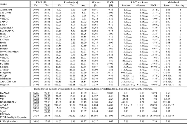
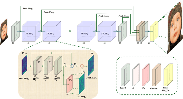


Abstract:This paper provides a comprehensive review of the NTIRE 2024 challenge, focusing on efficient single-image super-resolution (ESR) solutions and their outcomes. The task of this challenge is to super-resolve an input image with a magnification factor of x4 based on pairs of low and corresponding high-resolution images. The primary objective is to develop networks that optimize various aspects such as runtime, parameters, and FLOPs, while still maintaining a peak signal-to-noise ratio (PSNR) of approximately 26.90 dB on the DIV2K_LSDIR_valid dataset and 26.99 dB on the DIV2K_LSDIR_test dataset. In addition, this challenge has 4 tracks including the main track (overall performance), sub-track 1 (runtime), sub-track 2 (FLOPs), and sub-track 3 (parameters). In the main track, all three metrics (ie runtime, FLOPs, and parameter count) were considered. The ranking of the main track is calculated based on a weighted sum-up of the scores of all other sub-tracks. In sub-track 1, the practical runtime performance of the submissions was evaluated, and the corresponding score was used to determine the ranking. In sub-track 2, the number of FLOPs was considered. The score calculated based on the corresponding FLOPs was used to determine the ranking. In sub-track 3, the number of parameters was considered. The score calculated based on the corresponding parameters was used to determine the ranking. RLFN is set as the baseline for efficiency measurement. The challenge had 262 registered participants, and 34 teams made valid submissions. They gauge the state-of-the-art in efficient single-image super-resolution. To facilitate the reproducibility of the challenge and enable other researchers to build upon these findings, the code and the pre-trained model of validated solutions are made publicly available at https://github.com/Amazingren/NTIRE2024_ESR/.
Learning Exhaustive Correlation for Spectral Super-Resolution: Where Unified Spatial-Spectral Attention Meets Mutual Linear Dependence
Dec 20, 2023Abstract:Spectral super-resolution from the easily obtainable RGB image to hyperspectral image (HSI) has drawn increasing interest in the field of computational photography. The crucial aspect of spectral super-resolution lies in exploiting the correlation within HSIs. However, two types of bottlenecks in existing Transformers limit performance improvement and practical applications. First, existing Transformers often separately emphasize either spatial-wise or spectral-wise correlation, disrupting the 3D features of HSI and hindering the exploitation of unified spatial-spectral correlation. Second, the existing self-attention mechanism learns the correlation between pairs of tokens and captures the full-rank correlation matrix, leading to its inability to establish mutual linear dependence among multiple tokens. To address these issues, we propose a novel Exhaustive Correlation Transformer (ECT) for spectral super-resolution. First, we propose a Spectral-wise Discontinuous 3D (SD3D) splitting strategy, which models unified spatial-spectral correlation by simultaneously utilizing spatial-wise continuous splitting and spectral-wise discontinuous splitting. Second, we propose a Dynamic Low-Rank Mapping (DLRM) model, which captures mutual linear dependence among multiple tokens through a dynamically calculated low-rank dependence map. By integrating unified spatial-spectral attention with mutual linear dependence, our ECT can establish exhaustive correlation within HSI. The experimental results on both simulated and real data indicate that our method achieves state-of-the-art performance. Codes and pretrained models will be available later.
Spacecraft depth completion based on the gray image and the sparse depth map
Aug 30, 2022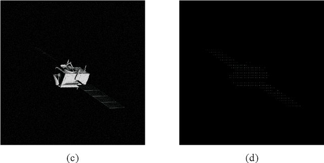
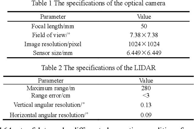


Abstract:Perceiving the three-dimensional (3D) structure of the spacecraft is a prerequisite for successfully executing many on-orbit space missions, and it can provide critical input for many downstream vision algorithms. In this paper, we propose to sense the 3D structure of spacecraft using light detection and ranging sensor (LIDAR) and a monocular camera. To this end, Spacecraft Depth Completion Network (SDCNet) is proposed to recover the dense depth map based on gray image and sparse depth map. Specifically, SDCNet decomposes the object-level spacecraft depth completion task into foreground segmentation subtask and foreground depth completion subtask, which segments the spacecraft region first and then performs depth completion on the segmented foreground area. In this way, the background interference to foreground spacecraft depth completion is effectively avoided. Moreover, an attention-based feature fusion module is also proposed to aggregate the complementary information between different inputs, which deduces the correlation between different features along the channel and the spatial dimension sequentially. Besides, four metrics are also proposed to evaluate object-level depth completion performance, which can more intuitively reflect the quality of spacecraft depth completion results. Finally, a large-scale satellite depth completion dataset is constructed for training and testing spacecraft depth completion algorithms. Empirical experiments on the dataset demonstrate the effectiveness of the proposed SDCNet, which achieves 0.25m mean absolute error of interest and 0.759m mean absolute truncation error, surpassing state-of-the-art methods by a large margin. The spacecraft pose estimation experiment is also conducted based on the depth completion results, and the experimental results indicate that the predicted dense depth map could meet the needs of downstream vision tasks.
SHREC'22 Track: Sketch-Based 3D Shape Retrieval in the Wild
Jul 11, 2022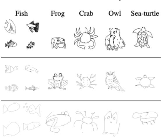

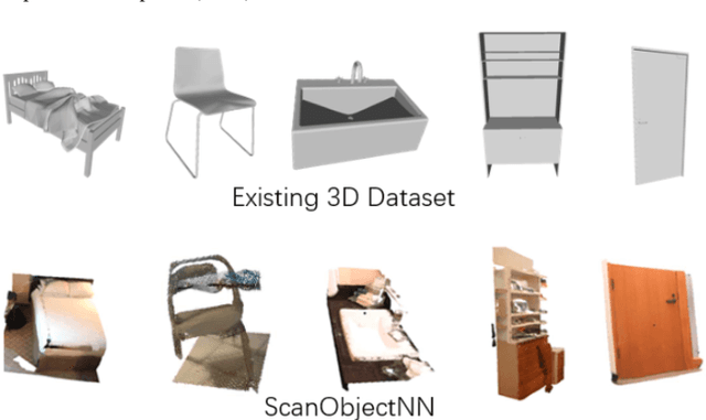

Abstract:Sketch-based 3D shape retrieval (SBSR) is an important yet challenging task, which has drawn more and more attention in recent years. Existing approaches address the problem in a restricted setting, without appropriately simulating real application scenarios. To mimic the realistic setting, in this track, we adopt large-scale sketches drawn by amateurs of different levels of drawing skills, as well as a variety of 3D shapes including not only CAD models but also models scanned from real objects. We define two SBSR tasks and construct two benchmarks consisting of more than 46,000 CAD models, 1,700 realistic models, and 145,000 sketches in total. Four teams participated in this track and submitted 15 runs for the two tasks, evaluated by 7 commonly-adopted metrics. We hope that, the benchmarks, the comparative results, and the open-sourced evaluation code will foster future research in this direction among the 3D object retrieval community.
 Add to Chrome
 Add to Firefox
 Add to Edge