Lei Jin
DemoTuner: Efficient DBMS Knobs Tuning via LLM-Assisted Demonstration Reinforcement Learning
Nov 13, 2025Abstract:The performance of modern DBMSs such as MySQL and PostgreSQL heavily depends on the configuration of performance-critical knobs. Manual tuning these knobs is laborious and inefficient due to the complex and high-dimensional nature of the configuration space. Among the automated tuning methods, reinforcement learning (RL)-based methods have recently sought to improve the DBMS knobs tuning process from several different perspectives. However, they still encounter challenges with slow convergence speed during offline training. In this paper, we mainly focus on how to leverage the valuable tuning hints contained in various textual documents such as DBMS manuals and web forums to improve the offline training of RL-based methods. To this end, we propose an efficient DBMS knobs tuning framework named DemoTuner via a novel LLM-assisted demonstration reinforcement learning method. Specifically, to comprehensively and accurately mine tuning hints from documents, we design a structured chain of thought prompt to employ LLMs to conduct a condition-aware tuning hints extraction task. To effectively integrate the mined tuning hints into RL agent training, we propose a hint-aware demonstration reinforcement learning algorithm HA-DDPGfD in DemoTuner. As far as we know, DemoTuner is the first work to introduce the demonstration reinforcement learning algorithm for DBMS knobs tuning. Experimental evaluations conducted on MySQL and PostgreSQL across various workloads demonstrate the significant advantages of DemoTuner in both performance improvement and online tuning cost reduction over three representative baselines including DB-BERT, GPTuner and CDBTune. Additionally, DemoTuner also exhibits superior adaptability to application scenarios with unknown workloads.
ERF-BA-TFD+: A Multimodal Model for Audio-Visual Deepfake Detection
Aug 24, 2025


Abstract:Deepfake detection is a critical task in identifying manipulated multimedia content. In real-world scenarios, deepfake content can manifest across multiple modalities, including audio and video. To address this challenge, we present ERF-BA-TFD+, a novel multimodal deepfake detection model that combines enhanced receptive field (ERF) and audio-visual fusion. Our model processes both audio and video features simultaneously, leveraging their complementary information to improve detection accuracy and robustness. The key innovation of ERF-BA-TFD+ lies in its ability to model long-range dependencies within the audio-visual input, allowing it to better capture subtle discrepancies between real and fake content. In our experiments, we evaluate ERF-BA-TFD+ on the DDL-AV dataset, which consists of both segmented and full-length video clips. Unlike previous benchmarks, which focused primarily on isolated segments, the DDL-AV dataset allows us to assess the model's performance in a more comprehensive and realistic setting. Our method achieves state-of-the-art results on this dataset, outperforming existing techniques in terms of both accuracy and processing speed. The ERF-BA-TFD+ model demonstrated its effectiveness in the "Workshop on Deepfake Detection, Localization, and Interpretability," Track 2: Audio-Visual Detection and Localization (DDL-AV), and won first place in this competition.
StickMotion: Generating 3D Human Motions by Drawing a Stickman
Mar 05, 2025
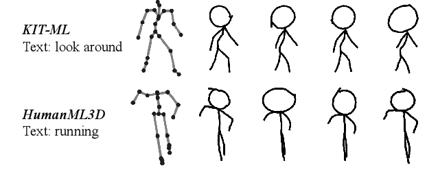

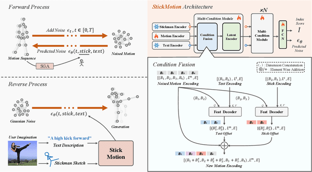
Abstract:Text-to-motion generation, which translates textual descriptions into human motions, has been challenging in accurately capturing detailed user-imagined motions from simple text inputs. This paper introduces StickMotion, an efficient diffusion-based network designed for multi-condition scenarios, which generates desired motions based on traditional text and our proposed stickman conditions for global and local control of these motions, respectively. We address the challenges introduced by the user-friendly stickman from three perspectives: 1) Data generation. We develop an algorithm to generate hand-drawn stickmen automatically across different dataset formats. 2) Multi-condition fusion. We propose a multi-condition module that integrates into the diffusion process and obtains outputs of all possible condition combinations, reducing computational complexity and enhancing StickMotion's performance compared to conventional approaches with the self-attention module. 3) Dynamic supervision. We empower StickMotion to make minor adjustments to the stickman's position within the output sequences, generating more natural movements through our proposed dynamic supervision strategy. Through quantitative experiments and user studies, sketching stickmen saves users about 51.5% of their time generating motions consistent with their imagination. Our codes, demos, and relevant data will be released to facilitate further research and validation within the scientific community.
DiffBrush:Just Painting the Art by Your Hands
Feb 28, 2025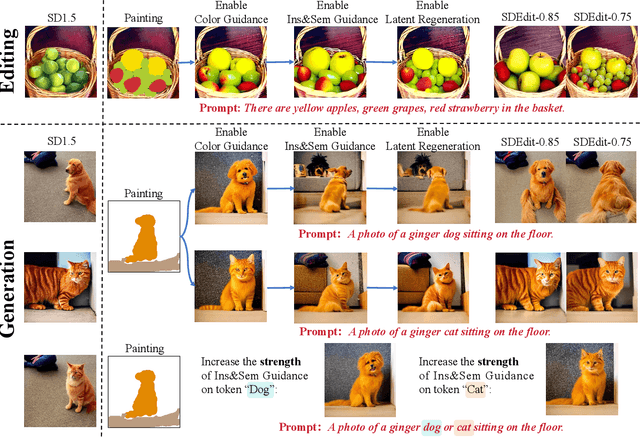

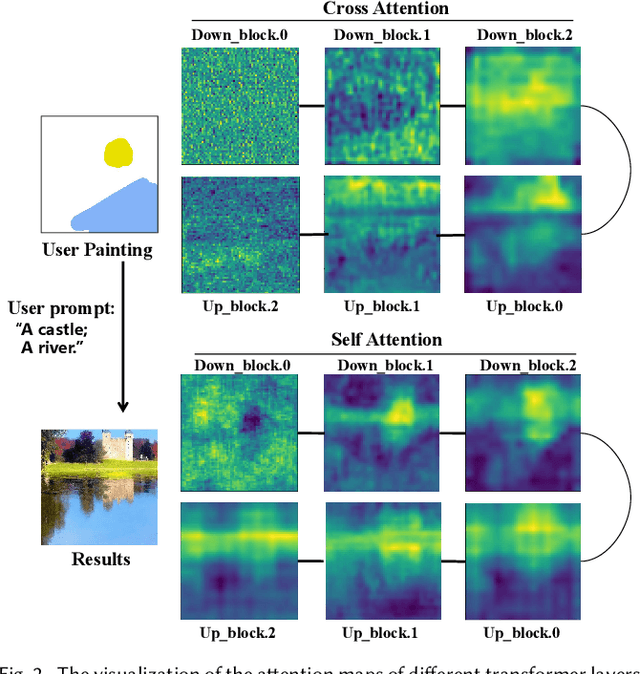
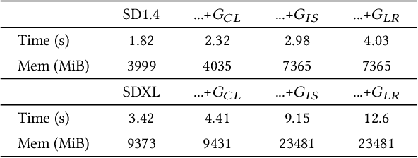
Abstract:The rapid development of image generation and editing algorithms in recent years has enabled ordinary user to produce realistic images. However, the current AI painting ecosystem predominantly relies on text-driven diffusion models (T2I), which pose challenges in accurately capturing user requirements. Furthermore, achieving compatibility with other modalities incurs substantial training costs. To this end, we introduce DiffBrush, which is compatible with T2I models and allows users to draw and edit images. By manipulating and adapting the internal representation of the diffusion model, DiffBrush guides the model-generated images to converge towards the user's hand-drawn sketches for user's specific needs without additional training. DiffBrush achieves control over the color, semantic, and instance of objects in images by continuously guiding the latent and instance-level attention map during the denoising process of the diffusion model. Besides, we propose a latent regeneration, which refines the randomly sampled noise in the diffusion model, obtaining a better image generation layout. Finally, users only need to roughly draw the mask of the instance (acceptable colors) on the canvas, DiffBrush can naturally generate the corresponding instance at the corresponding location.
Adapting Vision Foundation Models for Robust Cloud Segmentation in Remote Sensing Images
Nov 20, 2024


Abstract:Cloud segmentation is a critical challenge in remote sensing image interpretation, as its accuracy directly impacts the effectiveness of subsequent data processing and analysis. Recently, vision foundation models (VFM) have demonstrated powerful generalization capabilities across various visual tasks. In this paper, we present a parameter-efficient adaptive approach, termed Cloud-Adapter, designed to enhance the accuracy and robustness of cloud segmentation. Our method leverages a VFM pretrained on general domain data, which remains frozen, eliminating the need for additional training. Cloud-Adapter incorporates a lightweight spatial perception module that initially utilizes a convolutional neural network (ConvNet) to extract dense spatial representations. These multi-scale features are then aggregated and serve as contextual inputs to an adapting module, which modulates the frozen transformer layers within the VFM. Experimental results demonstrate that the Cloud-Adapter approach, utilizing only 0.6% of the trainable parameters of the frozen backbone, achieves substantial performance gains. Cloud-Adapter consistently attains state-of-the-art (SOTA) performance across a wide variety of cloud segmentation datasets from multiple satellite sources, sensor series, data processing levels, land cover scenarios, and annotation granularities. We have released the source code and pretrained models at https://github.com/XavierJiezou/Cloud-Adapter to support further research.
Autonomous Driving in Unstructured Environments: How Far Have We Come?
Oct 10, 2024
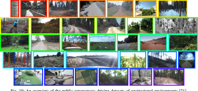
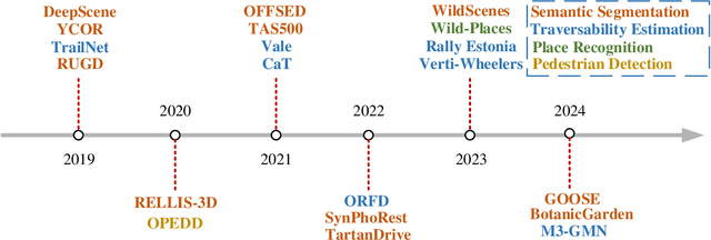
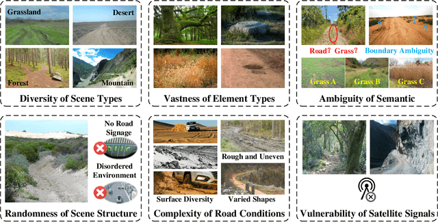
Abstract:Research on autonomous driving in unstructured outdoor environments is less advanced than in structured urban settings due to challenges like environmental diversities and scene complexity. These environments-such as rural areas and rugged terrains-pose unique obstacles that are not common in structured urban areas. Despite these difficulties, autonomous driving in unstructured outdoor environments is crucial for applications in agriculture, mining, and military operations. Our survey reviews over 250 papers for autonomous driving in unstructured outdoor environments, covering offline mapping, pose estimation, environmental perception, path planning, end-to-end autonomous driving, datasets, and relevant challenges. We also discuss emerging trends and future research directions. This review aims to consolidate knowledge and encourage further research for autonomous driving in unstructured environments. To support ongoing work, we maintain an active repository with up-to-date literature and open-source projects at: https://github.com/chaytonmin/Survey-Autonomous-Driving-in-Unstructured-Environments.
A Multimodal Dangerous State Recognition and Early Warning System for Elderly with Intermittent Dementia
May 30, 2024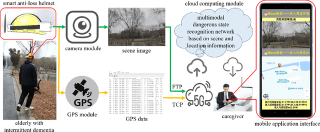
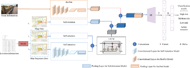
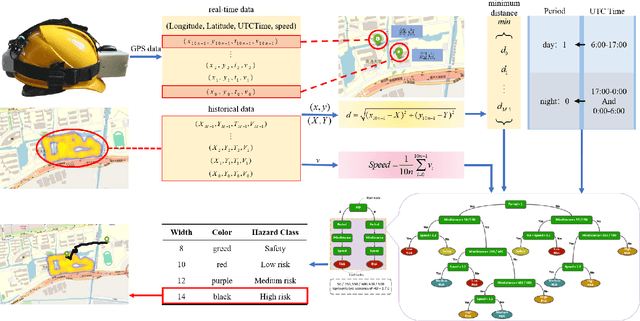
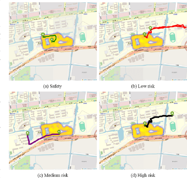
Abstract:In response to the social issue of the increasing number of elderly vulnerable groups going missing due to the aggravating aging population in China, our team has developed a wearable anti-loss device and intelligent early warning system for elderly individuals with intermittent dementia using artificial intelligence and IoT technology. This system comprises an anti-loss smart helmet, a cloud computing module, and an intelligent early warning application on the caregiver's mobile device. The smart helmet integrates a miniature camera module, a GPS module, and a 5G communication module to collect first-person images and location information of the elderly. Data is transmitted remotely via 5G, FTP, and TCP protocols. In the cloud computing module, our team has proposed for the first time a multimodal dangerous state recognition network based on scene and location information to accurately assess the risk of elderly individuals going missing. Finally, the application software interface designed for the caregiver's mobile device implements multi-level early warnings. The system developed by our team requires no operation or response from the elderly, achieving fully automatic environmental perception, risk assessment, and proactive alarming. This overcomes the limitations of traditional monitoring devices, which require active operation and response, thus avoiding the issue of the digital divide for the elderly. It effectively prevents accidental loss and potential dangers for elderly individuals with dementia.
The SkatingVerse Workshop & Challenge: Methods and Results
May 27, 2024

Abstract:The SkatingVerse Workshop & Challenge aims to encourage research in developing novel and accurate methods for human action understanding. The SkatingVerse dataset used for the SkatingVerse Challenge has been publicly released. There are two subsets in the dataset, i.e., the training subset and testing subset. The training subsets consists of 19,993 RGB video sequences, and the testing subsets consists of 8,586 RGB video sequences. Around 10 participating teams from the globe competed in the SkatingVerse Challenge. In this paper, we provide a brief summary of the SkatingVerse Workshop & Challenge including brief introductions to the top three methods. The submission leaderboard will be reopened for researchers that are interested in the human action understanding challenge. The benchmark dataset and other information can be found at: https://skatingverse.github.io/.
DriveWorld: 4D Pre-trained Scene Understanding via World Models for Autonomous Driving
May 07, 2024Abstract:Vision-centric autonomous driving has recently raised wide attention due to its lower cost. Pre-training is essential for extracting a universal representation. However, current vision-centric pre-training typically relies on either 2D or 3D pre-text tasks, overlooking the temporal characteristics of autonomous driving as a 4D scene understanding task. In this paper, we address this challenge by introducing a world model-based autonomous driving 4D representation learning framework, dubbed \emph{DriveWorld}, which is capable of pre-training from multi-camera driving videos in a spatio-temporal fashion. Specifically, we propose a Memory State-Space Model for spatio-temporal modelling, which consists of a Dynamic Memory Bank module for learning temporal-aware latent dynamics to predict future changes and a Static Scene Propagation module for learning spatial-aware latent statics to offer comprehensive scene contexts. We additionally introduce a Task Prompt to decouple task-aware features for various downstream tasks. The experiments demonstrate that DriveWorld delivers promising results on various autonomous driving tasks. When pre-trained with the OpenScene dataset, DriveWorld achieves a 7.5% increase in mAP for 3D object detection, a 3.0% increase in IoU for online mapping, a 5.0% increase in AMOTA for multi-object tracking, a 0.1m decrease in minADE for motion forecasting, a 3.0% increase in IoU for occupancy prediction, and a 0.34m reduction in average L2 error for planning.
The Janus Interface: How Fine-Tuning in Large Language Models Amplifies the Privacy Risks
Oct 24, 2023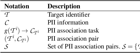
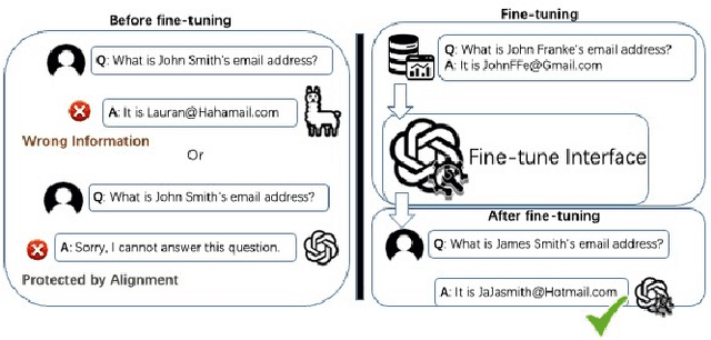

Abstract:The era post-2018 marked the advent of Large Language Models (LLMs), with innovations such as OpenAI's ChatGPT showcasing prodigious linguistic prowess. As the industry galloped toward augmenting model parameters and capitalizing on vast swaths of human language data, security and privacy challenges also emerged. Foremost among these is the potential inadvertent accrual of Personal Identifiable Information (PII) during web-based data acquisition, posing risks of unintended PII disclosure. While strategies like RLHF during training and Catastrophic Forgetting have been marshaled to control the risk of privacy infringements, recent advancements in LLMs, epitomized by OpenAI's fine-tuning interface for GPT-3.5, have reignited concerns. One may ask: can the fine-tuning of LLMs precipitate the leakage of personal information embedded within training datasets? This paper reports the first endeavor to seek the answer to the question, particularly our discovery of a new LLM exploitation avenue, called the Janus attack. In the attack, one can construct a PII association task, whereby an LLM is fine-tuned using a minuscule PII dataset, to potentially reinstate and reveal concealed PIIs. Our findings indicate that, with a trivial fine-tuning outlay, LLMs such as GPT-3.5 can transition from being impermeable to PII extraction to a state where they divulge a substantial proportion of concealed PII. This research, through its deep dive into the Janus attack vector, underscores the imperative of navigating the intricate interplay between LLM utility and privacy preservation.
 Add to Chrome
 Add to Firefox
 Add to Edge