Jianqiang Wang
ScenePilot-Bench: A Large-Scale Dataset and Benchmark for Evaluation of Vision-Language Models in Autonomous Driving
Jan 27, 2026Abstract:In this paper, we introduce ScenePilot-Bench, a large-scale first-person driving benchmark designed to evaluate vision-language models (VLMs) in autonomous driving scenarios. ScenePilot-Bench is built upon ScenePilot-4K, a diverse dataset comprising 3,847 hours of driving videos, annotated with multi-granularity information including scene descriptions, risk assessments, key participant identification, ego trajectories, and camera parameters. The benchmark features a four-axis evaluation suite that assesses VLM capabilities in scene understanding, spatial perception, motion planning, and GPT-Score, with safety-aware metrics and cross-region generalization settings. We benchmark representative VLMs on ScenePilot-Bench, providing empirical analyses that clarify current performance boundaries and identify gaps for driving-oriented reasoning. ScenePilot-Bench offers a comprehensive framework for evaluating and advancing VLMs in safety-critical autonomous driving contexts.
SymDrive: Realistic and Controllable Driving Simulator via Symmetric Auto-regressive Online Restoration
Dec 25, 2025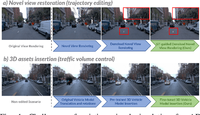
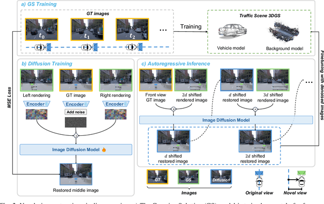
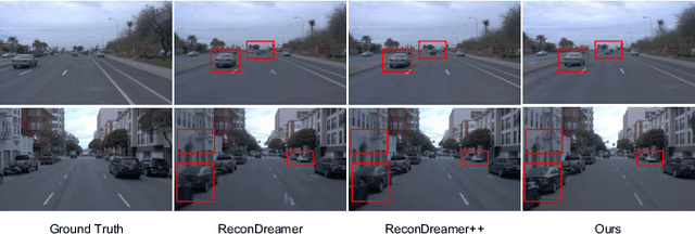
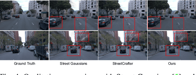
Abstract:High-fidelity and controllable 3D simulation is essential for addressing the long-tail data scarcity in Autonomous Driving (AD), yet existing methods struggle to simultaneously achieve photorealistic rendering and interactive traffic editing. Current approaches often falter in large-angle novel view synthesis and suffer from geometric or lighting artifacts during asset manipulation. To address these challenges, we propose SymDrive, a unified diffusion-based framework capable of joint high-quality rendering and scene editing. We introduce a Symmetric Auto-regressive Online Restoration paradigm, which constructs paired symmetric views to recover fine-grained details via a ground-truth-guided dual-view formulation and utilizes an auto-regressive strategy for consistent lateral view generation. Furthermore, we leverage this restoration capability to enable a training-free harmonization mechanism, treating vehicle insertion as context-aware inpainting to ensure seamless lighting and shadow consistency. Extensive experiments demonstrate that SymDrive achieves state-of-the-art performance in both novel-view enhancement and realistic 3D vehicle insertion.
Multimodal Classification Network Guided Trajectory Planning for Four-Wheel Independent Steering Autonomous Parking Considering Obstacle Attributes
Dec 21, 2025Abstract:Four-wheel Independent Steering (4WIS) vehicles have attracted increasing attention for their superior maneuverability. Human drivers typically choose to cross or drive over the low-profile obstacles (e.g., plastic bags) to efficiently navigate through narrow spaces, while existing planners neglect obstacle attributes, causing inefficiency or path-finding failures. To address this, we propose a trajectory planning framework integrating the 4WIS hybrid A* and Optimal Control Problem (OCP), in which the hybrid A* provides an initial path to enhance the OCP solution. Specifically, a multimodal classification network is introduced to assess scene complexity (hard/easy task) by fusing image and vehicle state data. For hard tasks, guided points are set to decompose complex tasks into local subtasks, improving the search efficiency of 4WIS hybrid A*. The multiple steering modes of 4WIS vehicles (Ackermann, diagonal, and zero-turn) are also incorporated into node expansion and heuristic designs. Moreover, a hierarchical obstacle handling strategy is designed to guide the node expansion considering obstacle attributes, i.e., 'non-traversable', 'crossable', and 'drive-over' obstacles. It allows crossing or driving over obstacles instead of the 'avoid-only' strategy, greatly enhancing success rates of pathfinding. We also design a logical constraint for the 'drive-over' obstacle by limiting its velocity to ensure safety. Furthermore, to address dynamic obstacles with motion uncertainty, we introduce a probabilistic risk field model, constructing risk-aware driving corridors that serve as linear collision constraints in OCP. Experimental results demonstrate the proposed framework's effectiveness in generating safe, efficient, and smooth trajectories for 4WIS vehicles, especially in constrained environments.
Modified-Emergency Index (MEI): A Criticality Metric for Autonomous Driving in Lateral Conflict
Oct 31, 2025Abstract:Effective, reliable, and efficient evaluation of autonomous driving safety is essential to demonstrate its trustworthiness. Criticality metrics provide an objective means of assessing safety. However, as existing metrics primarily target longitudinal conflicts, accurately quantifying the risks of lateral conflicts - prevalent in urban settings - remains challenging. This paper proposes the Modified-Emergency Index (MEI), a metric designed to quantify evasive effort in lateral conflicts. Compared to the original Emergency Index (EI), MEI refines the estimation of the time available for evasive maneuvers, enabling more precise risk quantification. We validate MEI on a public lateral conflict dataset based on Argoverse-2, from which we extract over 1,500 high-quality AV conflict cases, including more than 500 critical events. MEI is then compared with the well-established ACT and the widely used PET metrics. Results show that MEI consistently outperforms them in accurately quantifying criticality and capturing risk evolution. Overall, these findings highlight MEI as a promising metric for evaluating urban conflicts and enhancing the safety assessment framework for autonomous driving. The open-source implementation is available at https://github.com/AutoChengh/MEI.
LinguaSim: Interactive Multi-Vehicle Testing Scenario Generation via Natural Language Instruction Based on Large Language Models
Oct 09, 2025Abstract:The generation of testing and training scenarios for autonomous vehicles has drawn significant attention. While Large Language Models (LLMs) have enabled new scenario generation methods, current methods struggle to balance command adherence accuracy with the realism of real-world driving environments. To reduce scenario description complexity, these methods often compromise realism by limiting scenarios to 2D, or open-loop simulations where background vehicles follow predefined, non-interactive behaviors. We propose LinguaSim, an LLM-based framework that converts natural language into realistic, interactive 3D scenarios, ensuring both dynamic vehicle interactions and faithful alignment between the input descriptions and the generated scenarios. A feedback calibration module further refines the generation precision, improving fidelity to user intent. By bridging the gap between natural language and closed-loop, interactive simulations, LinguaSim constrains adversarial vehicle behaviors using both the scenario description and the autonomous driving model guiding them. This framework facilitates the creation of high-fidelity scenarios that enhance safety testing and training. Experiments show LinguaSim can generate scenarios with varying criticality aligned with different natural language descriptions (ACT: 0.072 s for dangerous vs. 3.532 s for safe descriptions; comfortability: 0.654 vs. 0.764), and its refinement module effectively reduces excessive aggressiveness in LinguaSim's initial outputs, lowering the crash rate from 46.9% to 6.3% to better match user intentions.
DenseFormer: Learning Dense Depth Map from Sparse Depth and Image via Conditional Diffusion Model
Mar 31, 2025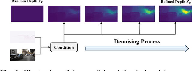
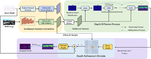
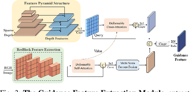
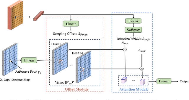
Abstract:The depth completion task is a critical problem in autonomous driving, involving the generation of dense depth maps from sparse depth maps and RGB images. Most existing methods employ a spatial propagation network to iteratively refine the depth map after obtaining an initial dense depth. In this paper, we propose DenseFormer, a novel method that integrates the diffusion model into the depth completion task. By incorporating the denoising mechanism of the diffusion model, DenseFormer generates the dense depth map by progressively refining an initial random depth distribution through multiple iterations. We propose a feature extraction module that leverages a feature pyramid structure, along with multi-layer deformable attention, to effectively extract and integrate features from sparse depth maps and RGB images, which serve as the guiding condition for the diffusion process. Additionally, this paper presents a depth refinement module that applies multi-step iterative refinement across various ranges to the dense depth results generated by the diffusion process. The module utilizes image features enriched with multi-scale information and sparse depth input to further enhance the accuracy of the predicted depth map. Extensive experiments on the KITTI outdoor scene dataset demonstrate that DenseFormer outperforms classical depth completion methods.
CTS-CBS: A New Approach for Multi-Agent Collaborative Task Sequencing and Path Finding
Mar 26, 2025Abstract:This paper addresses a generalization problem of Multi-Agent Pathfinding (MAPF), called Collaborative Task Sequencing - Multi-Agent Pathfinding (CTS-MAPF), where agents must plan collision-free paths and visit a series of intermediate task locations in a specific order before reaching their final destinations. To address this problem, we propose a new approach, Collaborative Task Sequencing - Conflict-Based Search (CTS-CBS), which conducts a two-level search. In the high level, it generates a search forest, where each tree corresponds to a joint task sequence derived from the jTSP solution. In the low level, CTS-CBS performs constrained single-agent path planning to generate paths for each agent while adhering to high-level constraints. We also provide heoretical guarantees of its completeness and optimality (or sub-optimality with a bounded parameter). To evaluate the performance of CTS-CBS, we create two datasets, CTS-MAPF and MG-MAPF, and conduct comprehensive experiments. The results show that CTS-CBS adaptations for MG-MAPF outperform baseline algorithms in terms of success rate (up to 20 times larger) and runtime (up to 100 times faster), with less than a 10% sacrifice in solution quality. Furthermore, CTS-CBS offers flexibility by allowing users to adjust the sub-optimality bound omega to balance between solution quality and efficiency. Finally, practical robot tests demonstrate the algorithm's applicability in real-world scenarios.
V2X-DGPE: Addressing Domain Gaps and Pose Errors for Robust Collaborative 3D Object Detection
Jan 04, 2025


Abstract:In V2X collaborative perception, the domain gaps between heterogeneous nodes pose a significant challenge for effective information fusion. Pose errors arising from latency and GPS localization noise further exacerbate the issue by leading to feature misalignment. To overcome these challenges, we propose V2X-DGPE, a high-accuracy and robust V2X feature-level collaborative perception framework. V2X-DGPE employs a Knowledge Distillation Framework and a Feature Compensation Module to learn domain-invariant representations from multi-source data, effectively reducing the feature distribution gap between vehicles and roadside infrastructure. Historical information is utilized to provide the model with a more comprehensive understanding of the current scene. Furthermore, a Collaborative Fusion Module leverages a heterogeneous self-attention mechanism to extract and integrate heterogeneous representations from vehicles and infrastructure. To address pose errors, V2X-DGPE introduces a deformable attention mechanism, enabling the model to adaptively focus on critical parts of the input features by dynamically offsetting sampling points. Extensive experiments on the real-world DAIR-V2X dataset demonstrate that the proposed method outperforms existing approaches, achieving state-of-the-art detection performance. The code is available at https://github.com/wangsch10/V2X-DGPE.
SafeDrive: Knowledge- and Data-Driven Risk-Sensitive Decision-Making for Autonomous Vehicles with Large Language Models
Dec 19, 2024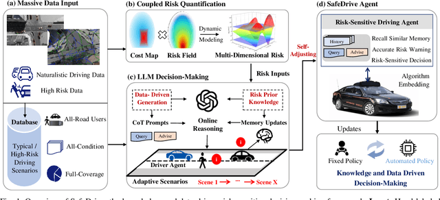
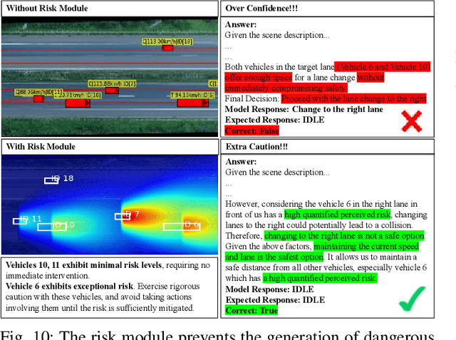
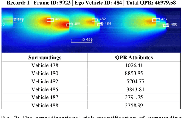
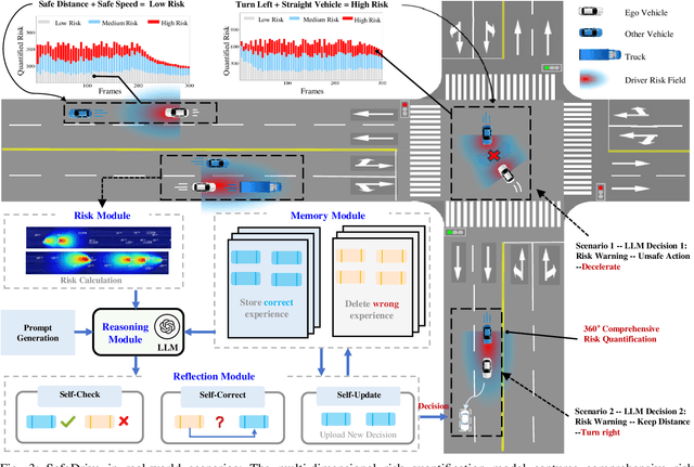
Abstract:Recent advancements in autonomous vehicles (AVs) use Large Language Models (LLMs) to perform well in normal driving scenarios. However, ensuring safety in dynamic, high-risk environments and managing safety-critical long-tail events remain significant challenges. To address these issues, we propose SafeDrive, a knowledge- and data-driven risk-sensitive decision-making framework to enhance AV safety and adaptability. The proposed framework introduces a modular system comprising: (1) a Risk Module for quantifying multi-factor coupled risks involving driver, vehicle, and road interactions; (2) a Memory Module for storing and retrieving typical scenarios to improve adaptability; (3) a LLM-powered Reasoning Module for context-aware safety decision-making; and (4) a Reflection Module for refining decisions through iterative learning. By integrating knowledge-driven insights with adaptive learning mechanisms, the framework ensures robust decision-making under uncertain conditions. Extensive evaluations on real-world traffic datasets, including highways (HighD), intersections (InD), and roundabouts (RounD), validate the framework's ability to enhance decision-making safety (achieving a 100% safety rate), replicate human-like driving behaviors (with decision alignment exceeding 85%), and adapt effectively to unpredictable scenarios. SafeDrive establishes a novel paradigm for integrating knowledge- and data-driven methods, highlighting significant potential to improve safety and adaptability of autonomous driving in high-risk traffic scenarios. Project Page: https://mezzi33.github.io/SafeDrive/
RINO: Accurate, Robust Radar-Inertial Odometry with Non-Iterative Estimation
Nov 12, 2024


Abstract:Precise localization and mapping are critical for achieving autonomous navigation in self-driving vehicles. However, ego-motion estimation still faces significant challenges, particularly when GNSS failures occur or under extreme weather conditions (e.g., fog, rain, and snow). In recent years, scanning radar has emerged as an effective solution due to its strong penetration capabilities. Nevertheless, scanning radar data inherently contains high levels of noise, necessitating hundreds to thousands of iterations of optimization to estimate a reliable transformation from the noisy data. Such iterative solving is time-consuming, unstable, and prone to failure. To address these challenges, we propose an accurate and robust Radar-Inertial Odometry system, RINO, which employs a non-iterative solving approach. Our method decouples rotation and translation estimation and applies an adaptive voting scheme for 2D rotation estimation, enhancing efficiency while ensuring consistent solving time. Additionally, the approach implements a loosely coupled system between the scanning radar and an inertial measurement unit (IMU), leveraging Error-State Kalman Filtering (ESKF). Notably, we successfully estimated the uncertainty of the pose estimation from the scanning radar, incorporating this into the filter's Maximum A Posteriori estimation, a consideration that has been previously overlooked. Validation on publicly available datasets demonstrates that RINO outperforms state-of-the-art methods and baselines in both accuracy and robustness. Our code is available at https://github.com/yangsc4063/rino.
 Add to Chrome
 Add to Firefox
 Add to Edge