Liu Ren
UniDrive-WM: Unified Understanding, Planning and Generation World Model For Autonomous Driving
Jan 07, 2026Abstract:World models have become central to autonomous driving, where accurate scene understanding and future prediction are crucial for safe control. Recent work has explored using vision-language models (VLMs) for planning, yet existing approaches typically treat perception, prediction, and planning as separate modules. We propose UniDrive-WM, a unified VLM-based world model that jointly performs driving-scene understanding, trajectory planning, and trajectory-conditioned future image generation within a single architecture. UniDrive-WM's trajectory planner predicts a future trajectory, which conditions a VLM-based image generator to produce plausible future frames. These predictions provide additional supervisory signals that enhance scene understanding and iteratively refine trajectory generation. We further compare discrete and continuous output representations for future image prediction, analyzing their influence on downstream driving performance. Experiments on the challenging Bench2Drive benchmark show that UniDrive-WM produces high-fidelity future images and improves planning performance by 5.9% in L2 trajectory error and 9.2% in collision rate over the previous best method. These results demonstrate the advantages of tightly integrating VLM-driven reasoning, planning, and generative world modeling for autonomous driving. The project page is available at https://unidrive-wm.github.io/UniDrive-WM .
Open Ad-hoc Categorization with Contextualized Feature Learning
Dec 18, 2025Abstract:Adaptive categorization of visual scenes is essential for AI agents to handle changing tasks. Unlike fixed common categories for plants or animals, ad-hoc categories are created dynamically to serve specific goals. We study open ad-hoc categorization: Given a few labeled exemplars and abundant unlabeled data, the goal is to discover the underlying context and to expand ad-hoc categories through semantic extension and visual clustering around it. Building on the insight that ad-hoc and common categories rely on similar perceptual mechanisms, we propose OAK, a simple model that introduces a small set of learnable context tokens at the input of a frozen CLIP and optimizes with both CLIP's image-text alignment objective and GCD's visual clustering objective. On Stanford and Clevr-4 datasets, OAK achieves state-of-the-art in accuracy and concept discovery across multiple categorizations, including 87.4% novel accuracy on Stanford Mood, surpassing CLIP and GCD by over 50%. Moreover, OAK produces interpretable saliency maps, focusing on hands for Action, faces for Mood, and backgrounds for Location, promoting transparency and trust while enabling adaptive and generalizable categorization.
* 26 pages, 17 figures
LAVQA: A Latency-Aware Visual Question Answering Framework for Shared Autonomy in Self-Driving Vehicles
Nov 14, 2025Abstract:When uncertainty is high, self-driving vehicles may halt for safety and benefit from the access to remote human operators who can provide high-level guidance. This paradigm, known as {shared autonomy}, enables autonomous vehicle and remote human operators to jointly formulate appropriate responses. To address critical decision timing with variable latency due to wireless network delays and human response time, we present LAVQA, a latency-aware shared autonomy framework that integrates Visual Question Answering (VQA) and spatiotemporal risk visualization. LAVQA augments visual queries with Latency-Induced COllision Map (LICOM), a dynamically evolving map that represents both temporal latency and spatial uncertainty. It enables remote operator to observe as the vehicle safety regions vary over time in the presence of dynamic obstacles and delayed responses. Closed-loop simulations in CARLA, the de-facto standard for autonomous vehicle simulator, suggest that that LAVQA can reduce collision rates by over 8x compared to latency-agnostic baselines.
3DGEER: Exact and Efficient Volumetric Rendering with 3D Gaussians
May 29, 2025Abstract:3D Gaussian Splatting (3DGS) marks a significant milestone in balancing the quality and efficiency of differentiable rendering. However, its high efficiency stems from an approximation of projecting 3D Gaussians onto the image plane as 2D Gaussians, which inherently limits rendering quality--particularly under large Field-of-View (FoV) camera inputs. While several recent works have extended 3DGS to mitigate these approximation errors, none have successfully achieved both exactness and high efficiency simultaneously. In this work, we introduce 3DGEER, an Exact and Efficient Volumetric Gaussian Rendering method. Starting from first principles, we derive a closed-form expression for the density integral along a ray traversing a 3D Gaussian distribution. This formulation enables precise forward rendering with arbitrary camera models and supports gradient-based optimization of 3D Gaussian parameters. To ensure both exactness and real-time performance, we propose an efficient method for computing a tight Particle Bounding Frustum (PBF) for each 3D Gaussian, enabling accurate and efficient ray-Gaussian association. We also introduce a novel Bipolar Equiangular Projection (BEAP) representation to accelerate ray association under generic camera models. BEAP further provides a more uniform ray sampling strategy to apply supervision, which empirically improves reconstruction quality. Experiments on multiple pinhole and fisheye datasets show that our method consistently outperforms prior methods, establishing a new state-of-the-art in real-time neural rendering.
DINO-R1: Incentivizing Reasoning Capability in Vision Foundation Models
May 29, 2025


Abstract:The recent explosive interest in the reasoning capabilities of large language models, such as DeepSeek-R1, has demonstrated remarkable success through reinforcement learning-based fine-tuning frameworks, exemplified by methods like Group Relative Policy Optimization (GRPO). However, such reasoning abilities remain underexplored and notably absent in vision foundation models, including representation models like the DINO series. In this work, we propose \textbf{DINO-R1}, the first such attempt to incentivize visual in-context reasoning capabilities of vision foundation models using reinforcement learning. Specifically, DINO-R1 introduces \textbf{Group Relative Query Optimization (GRQO)}, a novel reinforcement-style training strategy explicitly designed for query-based representation models, which computes query-level rewards based on group-normalized alignment quality. We also apply KL-regularization to stabilize the objectness distribution to reduce the training instability. This joint optimization enables dense and expressive supervision across queries while mitigating overfitting and distributional drift. Building upon Grounding-DINO, we train a series of DINO-R1 family models that integrate a visual prompt encoder and a visual-guided query selection mechanism. Extensive experiments on COCO, LVIS, and ODinW demonstrate that DINO-R1 significantly outperforms supervised fine-tuning baselines, achieving strong generalization in both open-vocabulary and closed-set visual prompting scenarios.
ALN-P3: Unified Language Alignment for Perception, Prediction, and Planning in Autonomous Driving
May 21, 2025Abstract:Recent advances have explored integrating large language models (LLMs) into end-to-end autonomous driving systems to enhance generalization and interpretability. However, most existing approaches are limited to either driving performance or vision-language reasoning, making it difficult to achieve both simultaneously. In this paper, we propose ALN-P3, a unified co-distillation framework that introduces cross-modal alignment between "fast" vision-based autonomous driving systems and "slow" language-driven reasoning modules. ALN-P3 incorporates three novel alignment mechanisms: Perception Alignment (P1A), Prediction Alignment (P2A), and Planning Alignment (P3A), which explicitly align visual tokens with corresponding linguistic outputs across the full perception, prediction, and planning stack. All alignment modules are applied only during training and incur no additional costs during inference. Extensive experiments on four challenging benchmarks-nuScenes, Nu-X, TOD3Cap, and nuScenes QA-demonstrate that ALN-P3 significantly improves both driving decisions and language reasoning, achieving state-of-the-art results.
LTDA-Drive: LLMs-guided Generative Models based Long-tail Data Augmentation for Autonomous Driving
May 21, 2025


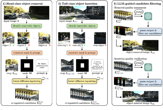
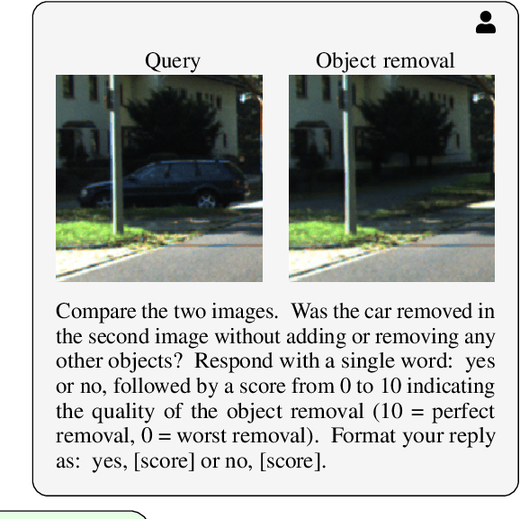
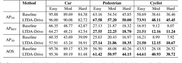
Abstract:3D perception plays an essential role for improving the safety and performance of autonomous driving. Yet, existing models trained on real-world datasets, which naturally exhibit long-tail distributions, tend to underperform on rare and safety-critical, vulnerable classes, such as pedestrians and cyclists. Existing studies on reweighting and resampling techniques struggle with the scarcity and limited diversity within tail classes. To address these limitations, we introduce LTDA-Drive, a novel LLM-guided data augmentation framework designed to synthesize diverse, high-quality long-tail samples. LTDA-Drive replaces head-class objects in driving scenes with tail-class objects through a three-stage process: (1) text-guided diffusion models remove head-class objects, (2) generative models insert instances of the tail classes, and (3) an LLM agent filters out low-quality synthesized images. Experiments conducted on the KITTI dataset show that LTDA-Drive significantly improves tail-class detection, achieving 34.75\% improvement for rare classes over counterpart methods. These results further highlight the effectiveness of LTDA-Drive in tackling long-tail challenges by generating high-quality and diverse data.
Generative AI for Autonomous Driving: Frontiers and Opportunities
May 13, 2025Abstract:Generative Artificial Intelligence (GenAI) constitutes a transformative technological wave that reconfigures industries through its unparalleled capabilities for content creation, reasoning, planning, and multimodal understanding. This revolutionary force offers the most promising path yet toward solving one of engineering's grandest challenges: achieving reliable, fully autonomous driving, particularly the pursuit of Level 5 autonomy. This survey delivers a comprehensive and critical synthesis of the emerging role of GenAI across the autonomous driving stack. We begin by distilling the principles and trade-offs of modern generative modeling, encompassing VAEs, GANs, Diffusion Models, and Large Language Models (LLMs). We then map their frontier applications in image, LiDAR, trajectory, occupancy, video generation as well as LLM-guided reasoning and decision making. We categorize practical applications, such as synthetic data workflows, end-to-end driving strategies, high-fidelity digital twin systems, smart transportation networks, and cross-domain transfer to embodied AI. We identify key obstacles and possibilities such as comprehensive generalization across rare cases, evaluation and safety checks, budget-limited implementation, regulatory compliance, ethical concerns, and environmental effects, while proposing research plans across theoretical assurances, trust metrics, transport integration, and socio-technical influence. By unifying these threads, the survey provides a forward-looking reference for researchers, engineers, and policymakers navigating the convergence of generative AI and advanced autonomous mobility. An actively maintained repository of cited works is available at https://github.com/taco-group/GenAI4AD.
VISLIX: An XAI Framework for Validating Vision Models with Slice Discovery and Analysis
May 06, 2025Abstract:Real-world machine learning models require rigorous evaluation before deployment, especially in safety-critical domains like autonomous driving and surveillance. The evaluation of machine learning models often focuses on data slices, which are subsets of the data that share a set of characteristics. Data slice finding automatically identifies conditions or data subgroups where models underperform, aiding developers in mitigating performance issues. Despite its popularity and effectiveness, data slicing for vision model validation faces several challenges. First, data slicing often needs additional image metadata or visual concepts, and falls short in certain computer vision tasks, such as object detection. Second, understanding data slices is a labor-intensive and mentally demanding process that heavily relies on the expert's domain knowledge. Third, data slicing lacks a human-in-the-loop solution that allows experts to form hypothesis and test them interactively. To overcome these limitations and better support the machine learning operations lifecycle, we introduce VISLIX, a novel visual analytics framework that employs state-of-the-art foundation models to help domain experts analyze slices in computer vision models. Our approach does not require image metadata or visual concepts, automatically generates natural language insights, and allows users to test data slice hypothesis interactively. We evaluate VISLIX with an expert study and three use cases, that demonstrate the effectiveness of our tool in providing comprehensive insights for validating object detection models.
Online Language Splatting
Mar 12, 2025Abstract:To enable AI agents to interact seamlessly with both humans and 3D environments, they must not only perceive the 3D world accurately but also align human language with 3D spatial representations. While prior work has made significant progress by integrating language features into geometrically detailed 3D scene representations using 3D Gaussian Splatting (GS), these approaches rely on computationally intensive offline preprocessing of language features for each input image, limiting adaptability to new environments. In this work, we introduce Online Language Splatting, the first framework to achieve online, near real-time, open-vocabulary language mapping within a 3DGS-SLAM system without requiring pre-generated language features. The key challenge lies in efficiently fusing high-dimensional language features into 3D representations while balancing the computation speed, memory usage, rendering quality and open-vocabulary capability. To this end, we innovatively design: (1) a high-resolution CLIP embedding module capable of generating detailed language feature maps in 18ms per frame, (2) a two-stage online auto-encoder that compresses 768-dimensional CLIP features to 15 dimensions while preserving open-vocabulary capabilities, and (3) a color-language disentangled optimization approach to improve rendering quality. Experimental results show that our online method not only surpasses the state-of-the-art offline methods in accuracy but also achieves more than 40x efficiency boost, demonstrating the potential for dynamic and interactive AI applications.
 Add to Chrome
 Add to Firefox
 Add to Edge