Zhitong Xiong
REOBench: Benchmarking Robustness of Earth Observation Foundation Models
May 22, 2025Abstract:Earth observation foundation models have shown strong generalization across multiple Earth observation tasks, but their robustness under real-world perturbations remains underexplored. To bridge this gap, we introduce REOBench, the first comprehensive benchmark for evaluating the robustness of Earth observation foundation models across six tasks and twelve types of image corruptions, including both appearance-based and geometric perturbations. To ensure realistic and fine-grained evaluation, our benchmark focuses on high-resolution optical remote sensing images, which are widely used in critical applications such as urban planning and disaster response. We conduct a systematic evaluation of a broad range of models trained using masked image modeling, contrastive learning, and vision-language pre-training paradigms. Our results reveal that (1) existing Earth observation foundation models experience significant performance degradation when exposed to input corruptions. (2) The severity of degradation varies across tasks, model architectures, backbone sizes, and types of corruption, with performance drop varying from less than 1% to over 20%. (3) Vision-language models show enhanced robustness, particularly in multimodal tasks. REOBench underscores the vulnerability of current Earth observation foundation models to real-world corruptions and provides actionable insights for developing more robust and reliable models.
GlobalGeoTree: A Multi-Granular Vision-Language Dataset for Global Tree Species Classification
May 18, 2025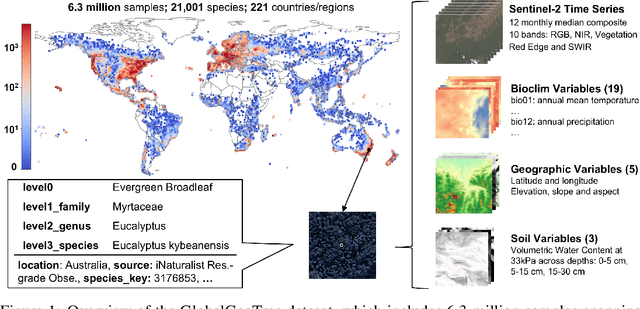

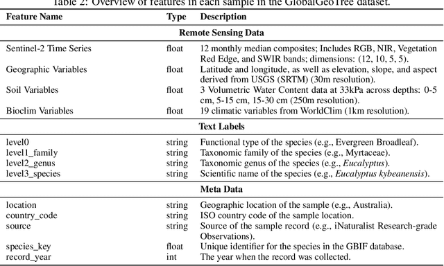
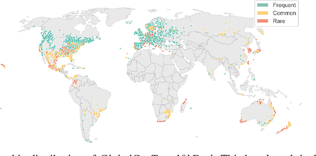
Abstract:Global tree species mapping using remote sensing data is vital for biodiversity monitoring, forest management, and ecological research. However, progress in this field has been constrained by the scarcity of large-scale, labeled datasets. To address this, we introduce GlobalGeoTree, a comprehensive global dataset for tree species classification. GlobalGeoTree comprises 6.3 million geolocated tree occurrences, spanning 275 families, 2,734 genera, and 21,001 species across the hierarchical taxonomic levels. Each sample is paired with Sentinel-2 image time series and 27 auxiliary environmental variables, encompassing bioclimatic, geographic, and soil data. The dataset is partitioned into GlobalGeoTree-6M for model pretraining and curated evaluation subsets, primarily GlobalGeoTree-10kEval for zero-shot and few-shot benchmarking. To demonstrate the utility of the dataset, we introduce a baseline model, GeoTreeCLIP, which leverages paired remote sensing data and taxonomic text labels within a vision-language framework pretrained on GlobalGeoTree-6M. Experimental results show that GeoTreeCLIP achieves substantial improvements in zero- and few-shot classification on GlobalGeoTree-10kEval over existing advanced models. By making the dataset, models, and code publicly available, we aim to establish a benchmark to advance tree species classification and foster innovation in biodiversity research and ecological applications.
ExEBench: Benchmarking Foundation Models on Extreme Earth Events
May 13, 2025Abstract:Our planet is facing increasingly frequent extreme events, which pose major risks to human lives and ecosystems. Recent advances in machine learning (ML), especially with foundation models (FMs) trained on extensive datasets, excel in extracting features and show promise in disaster management. Nevertheless, these models often inherit biases from training data, challenging their performance over extreme values. To explore the reliability of FM in the context of extreme events, we introduce \textbf{ExE}Bench (\textbf{Ex}treme \textbf{E}arth Benchmark), a collection of seven extreme event categories across floods, wildfires, storms, tropical cyclones, extreme precipitation, heatwaves, and cold waves. The dataset features global coverage, varying data volumes, and diverse data sources with different spatial, temporal, and spectral characteristics. To broaden the real-world impact of FMs, we include multiple challenging ML tasks that are closely aligned with operational needs in extreme events detection, monitoring, and forecasting. ExEBench aims to (1) assess FM generalizability across diverse, high-impact tasks and domains, (2) promote the development of novel ML methods that benefit disaster management, and (3) offer a platform for analyzing the interactions and cascading effects of extreme events to advance our understanding of Earth system, especially under the climate change expected in the decades to come. The dataset and code are public https://github.com/zhaoshan2/EarthExtreme-Bench.
Towards a Unified Copernicus Foundation Model for Earth Vision
Mar 14, 2025Abstract:Advances in Earth observation (EO) foundation models have unlocked the potential of big satellite data to learn generic representations from space, benefiting a wide range of downstream applications crucial to our planet. However, most existing efforts remain limited to fixed spectral sensors, focus solely on the Earth's surface, and overlook valuable metadata beyond imagery. In this work, we take a step towards next-generation EO foundation models with three key components: 1) Copernicus-Pretrain, a massive-scale pretraining dataset that integrates 18.7M aligned images from all major Copernicus Sentinel missions, spanning from the Earth's surface to its atmosphere; 2) Copernicus-FM, a unified foundation model capable of processing any spectral or non-spectral sensor modality using extended dynamic hypernetworks and flexible metadata encoding; and 3) Copernicus-Bench, a systematic evaluation benchmark with 15 hierarchical downstream tasks ranging from preprocessing to specialized applications for each Sentinel mission. Our dataset, model, and benchmark greatly improve the scalability, versatility, and multimodal adaptability of EO foundation models, while also creating new opportunities to connect EO, weather, and climate research. Codes, datasets and models are available at https://github.com/zhu-xlab/Copernicus-FM.
Panopticon: Advancing Any-Sensor Foundation Models for Earth Observation
Mar 13, 2025Abstract:Earth observation (EO) data features diverse sensing platforms with varying spectral bands, spatial resolutions, and sensing modalities. While most prior work has constrained inputs to fixed sensors, a new class of any-sensor foundation models able to process arbitrary sensors has recently emerged. Contributing to this line of work, we propose Panopticon, an any-sensor foundation model built on the DINOv2 framework. We extend DINOv2 by (1) treating images of the same geolocation across sensors as natural augmentations, (2) subsampling channels to diversify spectral input, and (3) adding a cross attention over channels as a flexible patch embedding mechanism. By encoding the wavelength and modes of optical and synthetic aperture radar sensors, respectively, Panopticon can effectively process any combination of arbitrary channels. In extensive evaluations, we achieve state-of-the-art performance on GEO-Bench, especially on the widely-used Sentinel-1 and Sentinel-2 sensors, while out-competing other any-sensor models, as well as domain adapted fixed-sensor models on unique sensor configurations. Panopticon enables immediate generalization to both existing and future satellite platforms, advancing sensor-agnostic EO.
GeoLangBind: Unifying Earth Observation with Agglomerative Vision-Language Foundation Models
Mar 08, 2025Abstract:Earth observation (EO) data, collected from diverse sensors with varying imaging principles, present significant challenges in creating unified analytical frameworks. We present GeoLangBind, a novel agglomerative vision--language foundation model that bridges the gap between heterogeneous EO data modalities using language as a unifying medium. Our approach aligns different EO data types into a shared language embedding space, enabling seamless integration and complementary feature learning from diverse sensor data. To achieve this, we construct a large-scale multimodal image--text dataset, GeoLangBind-2M, encompassing six data modalities. GeoLangBind leverages this dataset to develop a zero-shot foundation model capable of processing arbitrary numbers of EO data channels as input. Through our designed Modality-aware Knowledge Agglomeration (MaKA) module and progressive multimodal weight merging strategy, we create a powerful agglomerative foundation model that excels in both zero-shot vision--language comprehension and fine-grained visual understanding. Extensive evaluation across 23 datasets covering multiple tasks demonstrates GeoLangBind's superior performance and versatility in EO applications, offering a robust framework for various environmental monitoring and analysis tasks. The dataset and pretrained models will be publicly available.
Beyond Grid Data: Exploring Graph Neural Networks for Earth Observation
Nov 05, 2024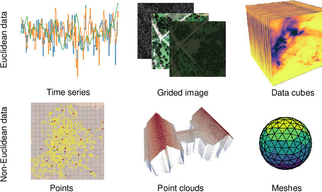
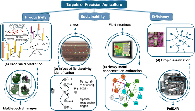
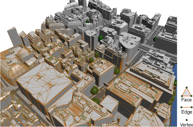
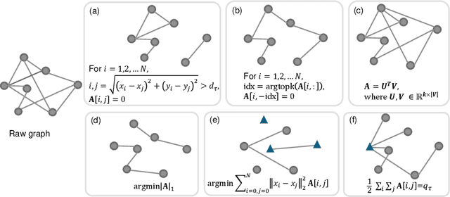
Abstract:Earth Observation (EO) data analysis has been significantly revolutionized by deep learning (DL), with applications typically limited to grid-like data structures. Graph Neural Networks (GNNs) emerge as an important innovation, propelling DL into the non-Euclidean domain. Naturally, GNNs can effectively tackle the challenges posed by diverse modalities, multiple sensors, and the heterogeneous nature of EO data. To introduce GNNs in the related domains, our review begins by offering fundamental knowledge on GNNs. Then, we summarize the generic problems in EO, to which GNNs can offer potential solutions. Following this, we explore a broad spectrum of GNNs' applications to scientific problems in Earth systems, covering areas such as weather and climate analysis, disaster management, air quality monitoring, agriculture, land cover classification, hydrological process modeling, and urban modeling. The rationale behind adopting GNNs in these fields is explained, alongside methodologies for organizing graphs and designing favorable architectures for various tasks. Furthermore, we highlight methodological challenges of implementing GNNs in these domains and possible solutions that could guide future research. While acknowledging that GNNs are not a universal solution, we conclude the paper by comparing them with other popular architectures like transformers and analyzing their potential synergies.
UrbanSARFloods: Sentinel-1 SLC-Based Benchmark Dataset for Urban and Open-Area Flood Mapping
Jun 06, 2024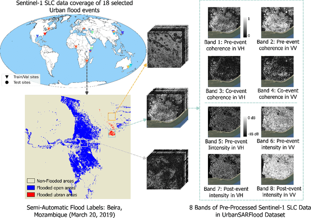
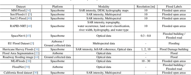
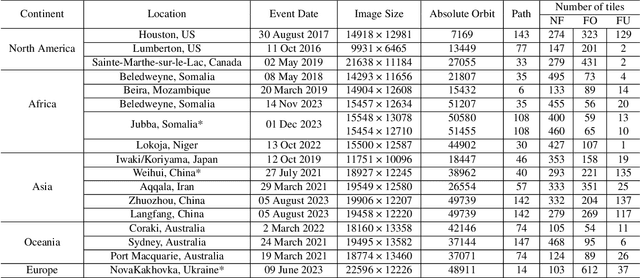
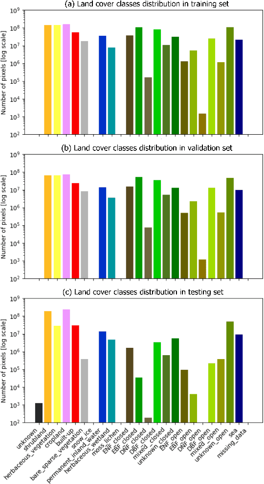
Abstract:Due to its cloud-penetrating capability and independence from solar illumination, satellite Synthetic Aperture Radar (SAR) is the preferred data source for large-scale flood mapping, providing global coverage and including various land cover classes. However, most studies on large-scale SAR-derived flood mapping using deep learning algorithms have primarily focused on flooded open areas, utilizing available open-access datasets (e.g., Sen1Floods11) and with limited attention to urban floods. To address this gap, we introduce \textbf{UrbanSARFloods}, a floodwater dataset featuring pre-processed Sentinel-1 intensity data and interferometric coherence imagery acquired before and during flood events. It contains 8,879 $512\times 512$ chips covering 807,500 $km^2$ across 20 land cover classes and 5 continents, spanning 18 flood events. We used UrbanSARFloods to benchmark existing state-of-the-art convolutional neural networks (CNNs) for segmenting open and urban flood areas. Our findings indicate that prevalent approaches, including the Weighted Cross-Entropy (WCE) loss and the application of transfer learning with pretrained models, fall short in overcoming the obstacles posed by imbalanced data and the constraints of a small training dataset. Urban flood detection remains challenging. Future research should explore strategies for addressing imbalanced data challenges and investigate transfer learning's potential for SAR-based large-scale flood mapping. Besides, expanding this dataset to include additional flood events holds promise for enhancing its utility and contributing to advancements in flood mapping techniques.
On the Foundations of Earth and Climate Foundation Models
May 07, 2024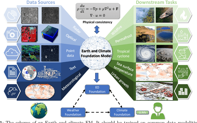
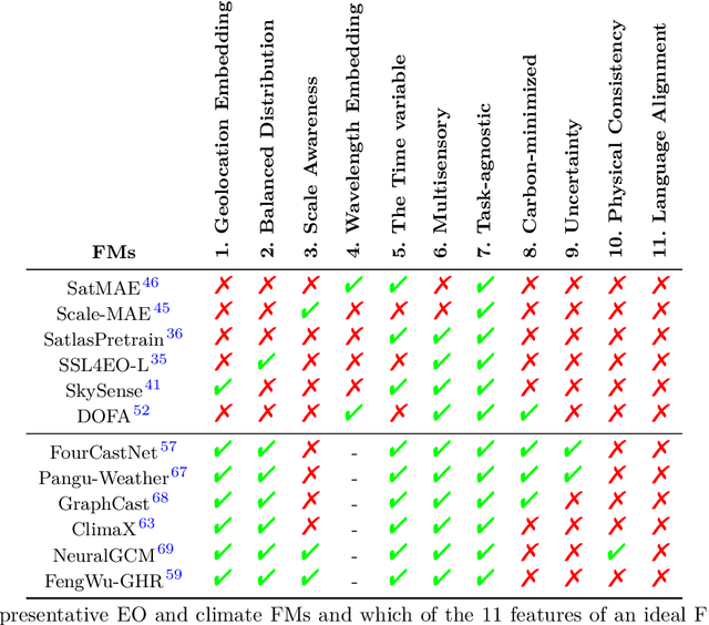
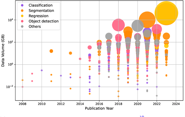
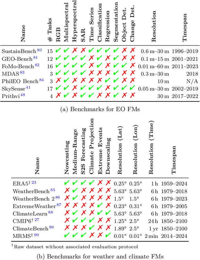
Abstract:Foundation models have enormous potential in advancing Earth and climate sciences, however, current approaches may not be optimal as they focus on a few basic features of a desirable Earth and climate foundation model. Crafting the ideal Earth foundation model, we define eleven features which would allow such a foundation model to be beneficial for any geoscientific downstream application in an environmental- and human-centric manner.We further shed light on the way forward to achieve the ideal model and to evaluate Earth foundation models. What comes after foundation models? Energy efficient adaptation, adversarial defenses, and interpretability are among the emerging directions.
Neural Plasticity-Inspired Foundation Model for Observing the Earth Crossing Modalities
Mar 22, 2024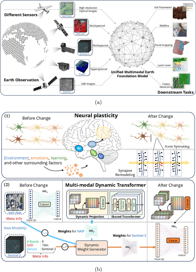
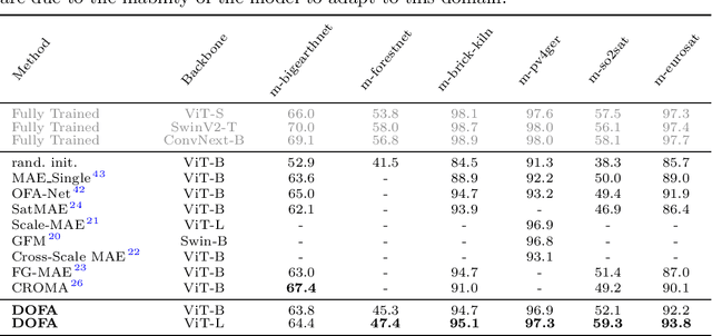
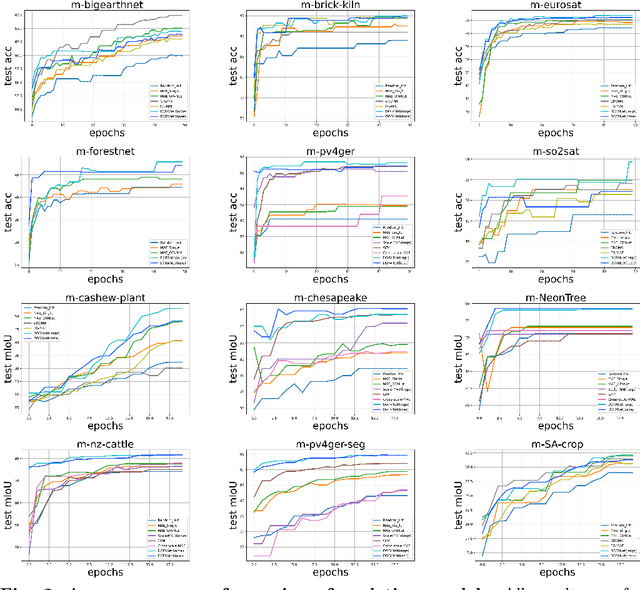
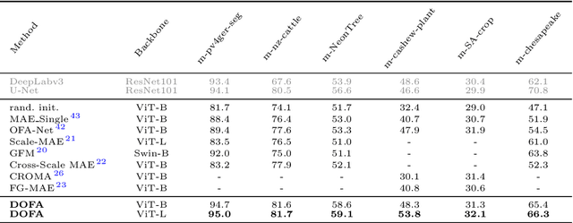
Abstract:The development of foundation models has revolutionized our ability to interpret the Earth's surface using satellite observational data. Traditional models have been siloed, tailored to specific sensors or data types like optical, radar, and hyperspectral, each with its own unique characteristics. This specialization hinders the potential for a holistic analysis that could benefit from the combined strengths of these diverse data sources. Our novel approach introduces the Dynamic One-For-All (DOFA) model, leveraging the concept of neural plasticity in brain science to integrate various data modalities into a single framework adaptively. This dynamic hypernetwork, adjusting to different wavelengths, enables a single versatile Transformer jointly trained on data from five sensors to excel across 12 distinct Earth observation tasks, including sensors never seen during pretraining. DOFA's innovative design offers a promising leap towards more accurate, efficient, and unified Earth observation analysis, showcasing remarkable adaptability and performance in harnessing the potential of multimodal Earth observation data.
 Add to Chrome
 Add to Firefox
 Add to Edge