Xiao Xiang Zhu
Technical University of Munich
Multitask Learning for Earth Observation Data Classification with Hybrid Quantum Network
Jan 29, 2026Abstract:Quantum machine learning (QML) has gained increasing attention as a potential solution to address the challenges of computation requirements in the future. Earth observation (EO) has entered the era of Big Data, and the computational demands for effectively analyzing large EO data with complex deep learning models have become a bottleneck. Motivated by this, we aim to leverage quantum computing for EO data classification and explore its advantages despite the current limitations of quantum devices. This paper presents a hybrid model that incorporates multitask learning to assist efficient data encoding and employs a location weight module with quantum convolution operations to extract valid features for classification. The validity of our proposed model was evaluated using multiple EO benchmarks. Additionally, we experimentally explored the generalizability of our model and investigated the factors contributing to its advantage, highlighting the potential of QML in EO data analysis.
Earth Embeddings as Products: Taxonomy, Ecosystem, and Standardized Access
Jan 19, 2026Abstract:Geospatial Foundation Models (GFMs) provide powerful representations, but high compute costs hinder their widespread use. Pre-computed embedding data products offer a practical "frozen" alternative, yet they currently exist in a fragmented ecosystem of incompatible formats and resolutions. This lack of standardization creates an engineering bottleneck that prevents meaningful model comparison and reproducibility. We formalize this landscape through a three-layer taxonomy: Data, Tools, and Value. We survey existing products to identify interoperability barriers. To bridge this gap, we extend TorchGeo with a unified API that standardizes the loading and querying of diverse embedding products. By treating embeddings as first-class geospatial datasets, we decouple downstream analysis from model-specific engineering, providing a roadmap for more transparent and accessible Earth observation workflows.
A Deep Dive into OpenStreetMap Research Since its Inception (2008-2024): Contributors, Topics, and Future Trends
Jan 14, 2026Abstract:OpenStreetMap (OSM) has transitioned from a pioneering volunteered geographic information (VGI) project into a global, multi-disciplinary research nexus. This study presents a bibliometric and systematic analysis of the OSM research landscape, examining its development trajectory and key driving forces. By evaluating 1,926 publications from the Web of Science (WoS) Core Collection and 782 State of the Map (SotM) presentations up to June 2024, we quantify publication growth, collaboration patterns, and thematic evolution. Results demonstrate simultaneous consolidation and diversification within the field. While a stable core of contributors continues to anchor OSM research, themes have shifted from initial concerns over data production and quality toward advanced analytical and applied uses. Comparative analysis of OSM-related research in WoS and SotM reveals distinct but complementary agendas between scholars and the OSM community. Building on these findings, we identify six emerging research directions and discuss how evolving partnerships among academia, the OSM community, and industry are poised to shape the future of OSM research. This study establishes a structured reference for understanding the state of OSM studies and offers strategic pathways for navigating its future trajectory.The data and code are available at https://github.com/ya0-sun/OSMbib.
Reconstructing Building Height from Spaceborne TomoSAR Point Clouds Using a Dual-Topology Network
Jan 02, 2026Abstract:Reliable building height estimation is essential for various urban applications. Spaceborne SAR tomography (TomoSAR) provides weather-independent, side-looking observations that capture facade-level structure, offering a promising alternative to conventional optical methods. However, TomoSAR point clouds often suffer from noise, anisotropic point distributions, and data voids on incoherent surfaces, all of which hinder accurate height reconstruction. To address these challenges, we introduce a learning-based framework for converting raw TomoSAR points into high-resolution building height maps. Our dual-topology network alternates between a point branch that models irregular scatterer features and a grid branch that enforces spatial consistency. By jointly processing these representations, the network denoises the input points and inpaints missing regions to produce continuous height estimates. To our knowledge, this is the first proof of concept for large-scale urban height mapping directly from TomoSAR point clouds. Extensive experiments on data from Munich and Berlin validate the effectiveness of our approach. Moreover, we demonstrate that our framework can be extended to incorporate optical satellite imagery, further enhancing reconstruction quality. The source code is available at https://github.com/zhu-xlab/tomosar2height.
Unified Primitive Proxies for Structured Shape Completion
Jan 02, 2026Abstract:Structured shape completion recovers missing geometry as primitives rather than as unstructured points, which enables primitive-based surface reconstruction. Instead of following the prevailing cascade, we rethink how primitives and points should interact, and find it more effective to decode primitives in a dedicated pathway that attends to shared shape features. Following this principle, we present UniCo, which in a single feed-forward pass predicts a set of primitives with complete geometry, semantics, and inlier membership. To drive this unified representation, we introduce primitive proxies, learnable queries that are contextualized to produce assembly-ready outputs. To ensure consistent optimization, our training strategy couples primitives and points with online target updates. Across synthetic and real-world benchmarks with four independent assembly solvers, UniCo consistently outperforms recent baselines, lowering Chamfer distance by up to 50% and improving normal consistency by up to 7%. These results establish an attractive recipe for structured 3D understanding from incomplete data. Project page: https://unico-completion.github.io.
GEO-Bench-2: From Performance to Capability, Rethinking Evaluation in Geospatial AI
Nov 19, 2025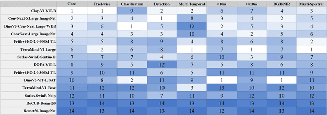
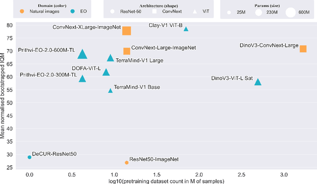
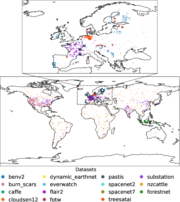
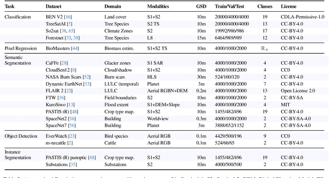
Abstract:Geospatial Foundation Models (GeoFMs) are transforming Earth Observation (EO), but evaluation lacks standardized protocols. GEO-Bench-2 addresses this with a comprehensive framework spanning classification, segmentation, regression, object detection, and instance segmentation across 19 permissively-licensed datasets. We introduce ''capability'' groups to rank models on datasets that share common characteristics (e.g., resolution, bands, temporality). This enables users to identify which models excel in each capability and determine which areas need improvement in future work. To support both fair comparison and methodological innovation, we define a prescriptive yet flexible evaluation protocol. This not only ensures consistency in benchmarking but also facilitates research into model adaptation strategies, a key and open challenge in advancing GeoFMs for downstream tasks. Our experiments show that no single model dominates across all tasks, confirming the specificity of the choices made during architecture design and pretraining. While models pretrained on natural images (ConvNext ImageNet, DINO V3) excel on high-resolution tasks, EO-specific models (TerraMind, Prithvi, and Clay) outperform them on multispectral applications such as agriculture and disaster response. These findings demonstrate that optimal model choice depends on task requirements, data modalities, and constraints. This shows that the goal of a single GeoFM model that performs well across all tasks remains open for future research. GEO-Bench-2 enables informed, reproducible GeoFM evaluation tailored to specific use cases. Code, data, and leaderboard for GEO-Bench-2 are publicly released under a permissive license.
ProPL: Universal Semi-Supervised Ultrasound Image Segmentation via Prompt-Guided Pseudo-Labeling
Nov 19, 2025


Abstract:Existing approaches for the problem of ultrasound image segmentation, whether supervised or semi-supervised, are typically specialized for specific anatomical structures or tasks, limiting their practical utility in clinical settings. In this paper, we pioneer the task of universal semi-supervised ultrasound image segmentation and propose ProPL, a framework that can handle multiple organs and segmentation tasks while leveraging both labeled and unlabeled data. At its core, ProPL employs a shared vision encoder coupled with prompt-guided dual decoders, enabling flexible task adaptation through a prompting-upon-decoding mechanism and reliable self-training via an uncertainty-driven pseudo-label calibration (UPLC) module. To facilitate research in this direction, we introduce a comprehensive ultrasound dataset spanning 5 organs and 8 segmentation tasks. Extensive experiments demonstrate that ProPL outperforms state-of-the-art methods across various metrics, establishing a new benchmark for universal ultrasound image segmentation.
FarSLIP: Discovering Effective CLIP Adaptation for Fine-Grained Remote Sensing Understanding
Nov 18, 2025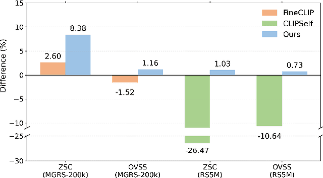
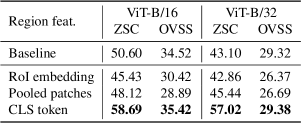
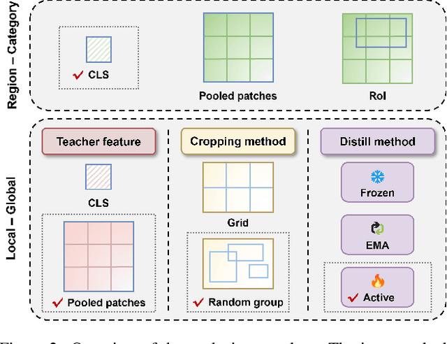

Abstract:As CLIP's global alignment limits its ability to capture fine-grained details, recent efforts have focused on enhancing its region-text alignment. However, current remote sensing (RS)-specific CLIP variants still inherit this limited spatial awareness. We identify two key limitations behind this: (1) current RS image-text datasets generate global captions from object-level labels, leaving the original object-level supervision underutilized; (2) despite the success of region-text alignment methods in general domain, their direct application to RS data often leads to performance degradation. To address these, we construct the first multi-granularity RS image-text dataset, MGRS-200k, featuring rich object-level textual supervision for RS region-category alignment. We further investigate existing fine-grained CLIP tuning strategies and find that current explicit region-text alignment methods, whether in a direct or indirect way, underperform due to severe degradation of CLIP's semantic coherence. Building on these, we propose FarSLIP, a Fine-grained Aligned RS Language-Image Pretraining framework. Rather than the commonly used patch-to-CLS self-distillation, FarSLIP employs patch-to-patch distillation to align local and global visual cues, which improves feature discriminability while preserving semantic coherence. Additionally, to effectively utilize region-text supervision, it employs simple CLS token-based region-category alignment rather than explicit patch-level alignment, further enhancing spatial awareness. FarSLIP features improved fine-grained vision-language alignment in RS domain and sets a new state of the art not only on RS open-vocabulary semantic segmentation, but also on image-level tasks such as zero-shot classification and image-text retrieval. Our dataset, code, and models are available at https://github.com/NJU-LHRS/FarSLIP.
TSE-Net: Semi-supervised Monocular Height Estimation from Single Remote Sensing Images
Nov 17, 2025


Abstract:Monocular height estimation plays a critical role in 3D perception for remote sensing, offering a cost-effective alternative to multi-view or LiDAR-based methods. While deep learning has significantly advanced the capabilities of monocular height estimation, these methods remain fundamentally limited by the availability of labeled data, which are expensive and labor-intensive to obtain at scale. The scarcity of high-quality annotations hinders the generalization and performance of existing models. To overcome this limitation, we propose leveraging large volumes of unlabeled data through a semi-supervised learning framework, enabling the model to extract informative cues from unlabeled samples and improve its predictive performance. In this work, we introduce TSE-Net, a self-training pipeline for semi-supervised monocular height estimation. The pipeline integrates teacher, student, and exam networks. The student network is trained on unlabeled data using pseudo-labels generated by the teacher network, while the exam network functions as a temporal ensemble of the student network to stabilize performance. The teacher network is formulated as a joint regression and classification model: the regression branch predicts height values that serve as pseudo-labels, and the classification branch predicts height value classes along with class probabilities, which are used to filter pseudo-labels. Height value classes are defined using a hierarchical bi-cut strategy to address the inherent long-tailed distribution of heights, and the predicted class probabilities are calibrated with a Plackett-Luce model to reflect the expected accuracy of pseudo-labels. We evaluate the proposed pipeline on three datasets spanning different resolutions and imaging modalities. Codes are available at https://github.com/zhu-xlab/tse-net.
LandSegmenter: Towards a Flexible Foundation Model for Land Use and Land Cover Mapping
Nov 11, 2025Abstract:Land Use and Land Cover (LULC) mapping is a fundamental task in Earth Observation (EO). However, current LULC models are typically developed for a specific modality and a fixed class taxonomy, limiting their generability and broader applicability. Recent advances in foundation models (FMs) offer promising opportunities for building universal models. Yet, task-agnostic FMs often require fine-tuning for downstream applications, whereas task-specific FMs rely on massive amounts of labeled data for training, which is costly and impractical in the remote sensing (RS) domain. To address these challenges, we propose LandSegmenter, an LULC FM framework that resolves three-stage challenges at the input, model, and output levels. From the input side, to alleviate the heavy demand on labeled data for FM training, we introduce LAnd Segment (LAS), a large-scale, multi-modal, multi-source dataset built primarily with globally sampled weak labels from existing LULC products. LAS provides a scalable, cost-effective alternative to manual annotation, enabling large-scale FM training across diverse LULC domains. For model architecture, LandSegmenter integrates an RS-specific adapter for cross-modal feature extraction and a text encoder for semantic awareness enhancement. At the output stage, we introduce a class-wise confidence-guided fusion strategy to mitigate semantic omissions and further improve LandSegmenter's zero-shot performance. We evaluate LandSegmenter on six precisely annotated LULC datasets spanning diverse modalities and class taxonomies. Extensive transfer learning and zero-shot experiments demonstrate that LandSegmenter achieves competitive or superior performance, particularly in zero-shot settings when transferred to unseen datasets. These results highlight the efficacy of our proposed framework and the utility of weak supervision for building task-specific FMs.
 Add to Chrome
 Add to Firefox
 Add to Edge