 Add to Chrome
 Add to Firefox
 Add to Edge
Hide and Seek: Investigating Redundancy in Earth Observation Imagery
Mar 13, 2026The growing availability of Earth Observation (EO) data and recent advances in Computer Vision have driven rapid progress in machine learning for EO, producing domain-specific models at ever-increasing scales. Yet this progress risks overlooking fundamental properties of EO data that distinguish it from other domains. We argue that EO data exhibit a multidimensional redundancy (spectral, temporal, spatial, and semantic) which has a more pronounced impact on the domain and its applications than what current literature reflects. To validate this hypothesis, we conduct a systematic domain-specific investigation examining the existence, consistency, and practical implications of this phenomenon across key dimensions of EO variability. Our findings confirm that redundancy in EO data is both substantial and pervasive: exploiting it yields comparable performance ($\approx98.5\%$ of baseline) at a fraction of the computational cost ($\approx4\times$ fewer GFLOPs), at both training and inference. Crucially, these gains are consistent across tasks, geospatial locations, sensors, ground sampling distances, and architectural designs; suggesting that multi-faceted redundancy is a structural property of EO data rather than an artifact of specific experimental choices. These results lay the groundwork for more efficient, scalable, and accessible large-scale EO models.
TIRAuxCloud: A Thermal Infrared Dataset for Day and Night Cloud Detection
Feb 25, 2026Clouds are a major obstacle in Earth observation, limiting the usability and reliability of critical remote sensing applications such as fire disaster response, urban heat island monitoring, and snow and ice cover mapping. Therefore, the ability to detect clouds 24/7 is of paramount importance. While visible and near-infrared bands are effective for daytime cloud detection, their dependence on solar illumination makes them unsuitable for nighttime monitoring. In contrast, thermal infrared (TIR) imagery plays a crucial role in detecting clouds at night, when sunlight is absent. Due to their generally lower temperatures, clouds emit distinct thermal signatures that are detectable in TIR bands. Despite this, accurate nighttime cloud detection remains challenging due to limited spectral information and the typically lower spatial resolution of TIR imagery. To address these challenges, we present TIRAuxCloud, a multi-modal dataset centered around thermal spectral data to facilitate cloud segmentation under both daytime and nighttime conditions. The dataset comprises a unique combination of multispectral data (TIR, optical, and near-infrared bands) from Landsat and VIIRS, aligned with auxiliary information layers. Elevation, land cover, meteorological variables, and cloud-free reference images are included to help reduce surface-cloud ambiguity and cloud formation uncertainty. To overcome the scarcity of manual cloud labels, we include a large set of samples with automated cloud masks and a smaller manually annotated subset to further evaluate and improve models. Comprehensive benchmarks are presented to establish performance baselines through supervised and transfer learning, demonstrating the dataset's value in advancing the development of innovative methods for day and night time cloud detection.
Hephaestus Minicubes: A Global, Multi-Modal Dataset for Volcanic Unrest Monitoring
May 23, 2025


Ground deformation is regarded in volcanology as a key precursor signal preceding volcanic eruptions. Satellite-based Interferometric Synthetic Aperture Radar (InSAR) enables consistent, global-scale deformation tracking; however, deep learning methods remain largely unexplored in this domain, mainly due to the lack of a curated machine learning dataset. In this work, we build on the existing Hephaestus dataset, and introduce Hephaestus Minicubes, a global collection of 38 spatiotemporal datacubes offering high resolution, multi-source and multi-temporal information, covering 44 of the world's most active volcanoes over a 7-year period. Each spatiotemporal datacube integrates InSAR products, topographic data, as well as atmospheric variables which are known to introduce signal delays that can mimic ground deformation in InSAR imagery. Furthermore, we provide expert annotations detailing the type, intensity and spatial extent of deformation events, along with rich text descriptions of the observed scenes. Finally, we present a comprehensive benchmark, demonstrating Hephaestus Minicubes' ability to support volcanic unrest monitoring as a multi-modal, multi-temporal classification and semantic segmentation task, establishing strong baselines with state-of-the-art architectures. This work aims to advance machine learning research in volcanic monitoring, contributing to the growing integration of data-driven methods within Earth science applications.
Probabilistic Machine Learning for Noisy Labels in Earth Observation
Apr 04, 2025Label noise poses a significant challenge in Earth Observation (EO), often degrading the performance and reliability of supervised Machine Learning (ML) models. Yet, given the critical nature of several EO applications, developing robust and trustworthy ML solutions is essential. In this study, we take a step in this direction by leveraging probabilistic ML to model input-dependent label noise and quantify data uncertainty in EO tasks, accounting for the unique noise sources inherent in the domain. We train uncertainty-aware probabilistic models across a broad range of high-impact EO applications-spanning diverse noise sources, input modalities, and ML configurations-and introduce a dedicated pipeline to assess their accuracy and reliability. Our experimental results show that the uncertainty-aware models consistently outperform the standard deterministic approaches across most datasets and evaluation metrics. Moreover, through rigorous uncertainty evaluation, we validate the reliability of the predicted uncertainty estimates, enhancing the interpretability of model predictions. Our findings emphasize the importance of modeling label noise and incorporating uncertainty quantification in EO, paving the way for more accurate, reliable, and trustworthy ML solutions in the field.
Towards a Unified Copernicus Foundation Model for Earth Vision
Mar 14, 2025Advances in Earth observation (EO) foundation models have unlocked the potential of big satellite data to learn generic representations from space, benefiting a wide range of downstream applications crucial to our planet. However, most existing efforts remain limited to fixed spectral sensors, focus solely on the Earth's surface, and overlook valuable metadata beyond imagery. In this work, we take a step towards next-generation EO foundation models with three key components: 1) Copernicus-Pretrain, a massive-scale pretraining dataset that integrates 18.7M aligned images from all major Copernicus Sentinel missions, spanning from the Earth's surface to its atmosphere; 2) Copernicus-FM, a unified foundation model capable of processing any spectral or non-spectral sensor modality using extended dynamic hypernetworks and flexible metadata encoding; and 3) Copernicus-Bench, a systematic evaluation benchmark with 15 hierarchical downstream tasks ranging from preprocessing to specialized applications for each Sentinel mission. Our dataset, model, and benchmark greatly improve the scalability, versatility, and multimodal adaptability of EO foundation models, while also creating new opportunities to connect EO, weather, and climate research. Codes, datasets and models are available at https://github.com/zhu-xlab/Copernicus-FM.
On the Generalization of Representation Uncertainty in Earth Observation
Mar 10, 2025Recent advances in Computer Vision have introduced the concept of pretrained representation uncertainty, enabling zero-shot uncertainty estimation. This holds significant potential for Earth Observation (EO), where trustworthiness is critical, yet the complexity of EO data poses challenges to uncertainty-aware methods. In this work, we investigate the generalization of representation uncertainty in EO, considering the domain's unique semantic characteristics. We pretrain uncertainties on large EO datasets and propose an evaluation framework to assess their zero-shot performance in multi-label classification and segmentation EO tasks. Our findings reveal that, unlike uncertainties pretrained on natural images, EO-pretraining exhibits strong generalization across unseen EO domains, geographic locations, and target granularities, while maintaining sensitivity to variations in ground sampling distance. We demonstrate the practical utility of pretrained uncertainties showcasing their alignment with task-specific uncertainties in downstream tasks, their sensitivity to real-world EO image noise, and their ability to generate spatial uncertainty estimates out-of-the-box. Initiating the discussion on representation uncertainty in EO, our study provides insights into its strengths and limitations, paving the way for future research in the field. Code and weights are available at: https://github.com/Orion-AI-Lab/EOUncertaintyGeneralization.
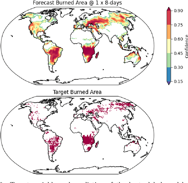
FireCastNet: Earth-as-a-Graph for Seasonal Fire Prediction
Feb 03, 2025


With climate change expected to exacerbate fire weather conditions, the accurate and timely anticipation of wildfires becomes increasingly crucial for disaster mitigation. In this study, we utilize SeasFire, a comprehensive global wildfire dataset with climate, vegetation, oceanic indices, and human-related variables, to enable seasonal wildfire forecasting with machine learning. For the predictive analysis, we present FireCastNet, a novel architecture which combines a 3D convolutional encoder with GraphCast, originally developed for global short-term weather forecasting using graph neural networks. FireCastNet is trained to capture the context leading to wildfires, at different spatial and temporal scales. Our investigation focuses on assessing the effectiveness of our model in predicting the presence of burned areas at varying forecasting time horizons globally, extending up to six months into the future, and on how different spatial or/and temporal context affects the performance. Our findings demonstrate the potential of deep learning models in seasonal fire forecasting; longer input time-series leads to more robust predictions, while integrating spatial information to capture wildfire spatio-temporal dynamics boosts performance. Finally, our results hint that in order to enhance performance at longer forecasting horizons, a larger receptive field spatially needs to be considered.
Seasonal Fire Prediction using Spatio-Temporal Deep Neural Networks
Apr 09, 2024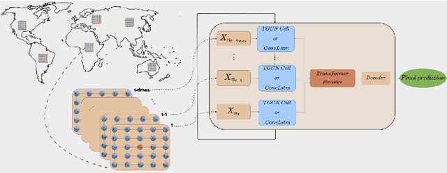


With climate change expected to exacerbate fire weather conditions, the accurate anticipation of wildfires on a global scale becomes increasingly crucial for disaster mitigation. In this study, we utilize SeasFire, a comprehensive global wildfire dataset with climate, vegetation, oceanic indices, and human-related variables, to enable seasonal wildfire forecasting with machine learning. For the predictive analysis, we train deep learning models with different architectures that capture the spatio-temporal context leading to wildfires. Our investigation focuses on assessing the effectiveness of these models in predicting the presence of burned areas at varying forecasting time horizons globally, extending up to six months into the future, and on how different spatial or/and temporal context affects the performance of the models. Our findings demonstrate the great potential of deep learning models in seasonal fire forecasting; longer input time-series leads to more robust predictions across varying forecasting horizons, while integrating spatial information to capture wildfire spatio-temporal dynamics boosts performance. Finally, our results hint that in order to enhance performance at longer forecasting horizons, a larger receptive field spatially needs to be considered.
FoMo-Bench: a multi-modal, multi-scale and multi-task Forest Monitoring Benchmark for remote sensing foundation models
Dec 15, 2023


Forests are an essential part of Earth's ecosystems and natural systems, as well as providing services on which humanity depends, yet they are rapidly changing as a result of land use decisions and climate change. Understanding and mitigating negative effects requires parsing data on forests at global scale from a broad array of sensory modalities, and recently many such problems have been approached using machine learning algorithms for remote sensing. To date, forest-monitoring problems have largely been approached in isolation. Inspired by the rise of foundation models for computer vision and remote sensing, we here present the first unified Forest Monitoring Benchmark (FoMo-Bench). FoMo-Bench consists of 15 diverse datasets encompassing satellite, aerial, and inventory data, covering a variety of geographical regions, and including multispectral, red-green-blue, synthetic aperture radar (SAR) and LiDAR data with various temporal, spatial and spectral resolutions. FoMo-Bench includes multiple types of forest-monitoring tasks, spanning classification, segmentation, and object detection. To further enhance the diversity of tasks and geographies represented in FoMo-Bench, we introduce a novel global dataset, TalloS, combining satellite imagery with ground-based annotations for tree species classification, spanning 1,000+ hierarchical taxonomic levels (species, genus, family). Finally, we propose FoMo-Net, a foundation model baseline designed for forest monitoring with the flexibility to process any combination of commonly used sensors in remote sensing. This work aims to inspire research collaborations between machine learning and forest biology researchers in exploring scalable multi-modal and multi-task models for forest monitoring. All code and data will be made publicly available.
Kuro Siwo: 12.1 billion $m^2$ under the water. A global multi-temporal satellite dataset for rapid flood mapping
Nov 18, 2023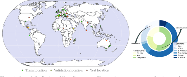
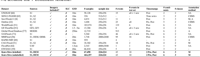
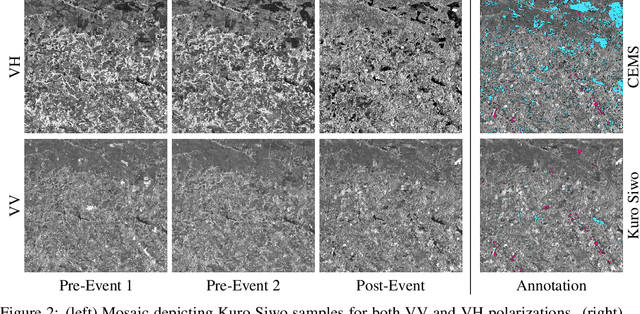
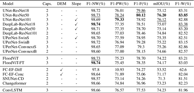
Global floods, exacerbated by climate change, pose severe threats to human life, infrastructure, and the environment. This urgency is highlighted by recent catastrophic events in Pakistan and New Zealand, underlining the critical need for precise flood mapping for guiding restoration efforts, understanding vulnerabilities, and preparing for future events. While Synthetic Aperture Radar (SAR) offers day-and-night, all-weather imaging capabilities, harnessing it for deep learning is hindered by the absence of a large annotated dataset. To bridge this gap, we introduce Kuro Siwo, a meticulously curated multi-temporal dataset, spanning 32 flood events globally. Our dataset maps more than 63 billion m2 of land, with 12.1 billion of them being either a flooded area or a permanent water body. Kuro Siwo stands out for its unparalleled annotation quality to facilitate rapid flood mapping in a supervised setting. We also augment learning by including a large unlabeled set of SAR samples, aimed at self-supervised pretraining. We provide an extensive benchmark and strong baselines for a diverse set of flood events from Europe, America, Africa and Australia. Our benchmark demonstrates the quality of Kuro Siwo annotations, training models that can achieve $\approx$ 85% and $\approx$ 87% in F1-score for flooded areas and general water detection respectively. This work calls on the deep learning community to develop solution-driven algorithms for rapid flood mapping, with the potential to aid civil protection and humanitarian agencies amid climate change challenges. Our code and data will be made available at https://github.com/Orion-AI-Lab/KuroSiwo