Arthur Ouaknine
Mila Quebec AI Institute, Canada, McGill University, Canada
SelvaMask: Segmenting Trees in Tropical Forests and Beyond
Feb 02, 2026Abstract:Tropical forests harbor most of the planet's tree biodiversity and are critical to global ecological balance. Canopy trees in particular play a disproportionate role in carbon storage and functioning of these ecosystems. Studying canopy trees at scale requires accurate delineation of individual tree crowns, typically performed using high-resolution aerial imagery. Despite advances in transformer-based models for individual tree crown segmentation, performance remains low in most forests, especially tropical ones. To this end, we introduce SelvaMask, a new tropical dataset containing over 8,800 manually delineated tree crowns across three Neotropical forest sites in Panama, Brazil, and Ecuador. SelvaMask features comprehensive annotations, including an inter-annotator agreement evaluation, capturing the dense structure of tropical forests and highlighting the difficulty of the task. Leveraging this benchmark, we propose a modular detection-segmentation pipeline that adapts vision foundation models (VFMs), using domain-specific detection-prompter. Our approach reaches state-of-the-art performance, outperforming both zero-shot generalist models and fully supervised end-to-end methods in dense tropical forests. We validate these gains on external tropical and temperate datasets, demonstrating that SelvaMask serves as both a challenging benchmark and a key enabler for generalized forest monitoring. Our code and dataset will be released publicly.
GreenHyperSpectra: A multi-source hyperspectral dataset for global vegetation trait prediction
Jul 09, 2025Abstract:Plant traits such as leaf carbon content and leaf mass are essential variables in the study of biodiversity and climate change. However, conventional field sampling cannot feasibly cover trait variation at ecologically meaningful spatial scales. Machine learning represents a valuable solution for plant trait prediction across ecosystems, leveraging hyperspectral data from remote sensing. Nevertheless, trait prediction from hyperspectral data is challenged by label scarcity and substantial domain shifts (\eg across sensors, ecological distributions), requiring robust cross-domain methods. Here, we present GreenHyperSpectra, a pretraining dataset encompassing real-world cross-sensor and cross-ecosystem samples designed to benchmark trait prediction with semi- and self-supervised methods. We adopt an evaluation framework encompassing in-distribution and out-of-distribution scenarios. We successfully leverage GreenHyperSpectra to pretrain label-efficient multi-output regression models that outperform the state-of-the-art supervised baseline. Our empirical analyses demonstrate substantial improvements in learning spectral representations for trait prediction, establishing a comprehensive methodological framework to catalyze research at the intersection of representation learning and plant functional traits assessment. All code and data are available at: https://github.com/echerif18/HyspectraSSL.
Bringing SAM to new heights: Leveraging elevation data for tree crown segmentation from drone imagery
Jun 05, 2025Abstract:Information on trees at the individual level is crucial for monitoring forest ecosystems and planning forest management. Current monitoring methods involve ground measurements, requiring extensive cost, time and labor. Advances in drone remote sensing and computer vision offer great potential for mapping individual trees from aerial imagery at broad-scale. Large pre-trained vision models, such as the Segment Anything Model (SAM), represent a particularly compelling choice given limited labeled data. In this work, we compare methods leveraging SAM for the task of automatic tree crown instance segmentation in high resolution drone imagery in three use cases: 1) boreal plantations, 2) temperate forests and 3) tropical forests. We also study the integration of elevation data into models, in the form of Digital Surface Model (DSM) information, which can readily be obtained at no additional cost from RGB drone imagery. We present BalSAM, a model leveraging SAM and DSM information, which shows potential over other methods, particularly in the context of plantations. We find that methods using SAM out-of-the-box do not outperform a custom Mask R-CNN, even with well-designed prompts. However, efficiently tuning SAM end-to-end and integrating DSM information are both promising avenues for tree crown instance segmentation models.
Assessing SAM for Tree Crown Instance Segmentation from Drone Imagery
Mar 26, 2025Abstract:The potential of tree planting as a natural climate solution is often undermined by inadequate monitoring of tree planting projects. Current monitoring methods involve measuring trees by hand for each species, requiring extensive cost, time, and labour. Advances in drone remote sensing and computer vision offer great potential for mapping and characterizing trees from aerial imagery, and large pre-trained vision models, such as the Segment Anything Model (SAM), may be a particularly compelling choice given limited labeled data. In this work, we compare SAM methods for the task of automatic tree crown instance segmentation in high resolution drone imagery of young tree plantations. We explore the potential of SAM for this task, and find that methods using SAM out-of-the-box do not outperform a custom Mask R-CNN, even with well-designed prompts, but that there is potential for methods which tune SAM further. We also show that predictions can be improved by adding Digital Surface Model (DSM) information as an input.
Tree semantic segmentation from aerial image time series
Jul 18, 2024


Abstract:Earth's forests play an important role in the fight against climate change, and are in turn negatively affected by it. Effective monitoring of different tree species is essential to understanding and improving the health and biodiversity of forests. In this work, we address the challenge of tree species identification by performing semantic segmentation of trees using an aerial image dataset spanning over a year. We compare models trained on single images versus those trained on time series to assess the impact of tree phenology on segmentation performances. We also introduce a simple convolutional block for extracting spatio-temporal features from image time series, enabling the use of popular pretrained backbones and methods. We leverage the hierarchical structure of tree species taxonomy by incorporating a custom loss function that refines predictions at three levels: species, genus, and higher-level taxa. Our findings demonstrate the superiority of our methodology in exploiting the time series modality and confirm that enriching labels using taxonomic information improves the semantic segmentation performance.
FoMo-Bench: a multi-modal, multi-scale and multi-task Forest Monitoring Benchmark for remote sensing foundation models
Dec 15, 2023


Abstract:Forests are an essential part of Earth's ecosystems and natural systems, as well as providing services on which humanity depends, yet they are rapidly changing as a result of land use decisions and climate change. Understanding and mitigating negative effects requires parsing data on forests at global scale from a broad array of sensory modalities, and recently many such problems have been approached using machine learning algorithms for remote sensing. To date, forest-monitoring problems have largely been approached in isolation. Inspired by the rise of foundation models for computer vision and remote sensing, we here present the first unified Forest Monitoring Benchmark (FoMo-Bench). FoMo-Bench consists of 15 diverse datasets encompassing satellite, aerial, and inventory data, covering a variety of geographical regions, and including multispectral, red-green-blue, synthetic aperture radar (SAR) and LiDAR data with various temporal, spatial and spectral resolutions. FoMo-Bench includes multiple types of forest-monitoring tasks, spanning classification, segmentation, and object detection. To further enhance the diversity of tasks and geographies represented in FoMo-Bench, we introduce a novel global dataset, TalloS, combining satellite imagery with ground-based annotations for tree species classification, spanning 1,000+ hierarchical taxonomic levels (species, genus, family). Finally, we propose FoMo-Net, a foundation model baseline designed for forest monitoring with the flexibility to process any combination of commonly used sensors in remote sensing. This work aims to inspire research collaborations between machine learning and forest biology researchers in exploring scalable multi-modal and multi-task models for forest monitoring. All code and data will be made publicly available.
OpenForest: A data catalogue for machine learning in forest monitoring
Nov 02, 2023Abstract:Forests play a crucial role in Earth's system processes and provide a suite of social and economic ecosystem services, but are significantly impacted by human activities, leading to a pronounced disruption of the equilibrium within ecosystems. Advancing forest monitoring worldwide offers advantages in mitigating human impacts and enhancing our comprehension of forest composition, alongside the effects of climate change. While statistical modeling has traditionally found applications in forest biology, recent strides in machine learning and computer vision have reached important milestones using remote sensing data, such as tree species identification, tree crown segmentation and forest biomass assessments. For this, the significance of open access data remains essential in enhancing such data-driven algorithms and methodologies. Here, we provide a comprehensive and extensive overview of 86 open access forest datasets across spatial scales, encompassing inventories, ground-based, aerial-based, satellite-based recordings, and country or world maps. These datasets are grouped in OpenForest, a dynamic catalogue open to contributions that strives to reference all available open access forest datasets. Moreover, in the context of these datasets, we aim to inspire research in machine learning applied to forest biology by establishing connections between contemporary topics, perspectives and challenges inherent in both domains. We hope to encourage collaborations among scientists, fostering the sharing and exploration of diverse datasets through the application of machine learning methods for large-scale forest monitoring. OpenForest is available at https://github.com/RolnickLab/OpenForest .
Deep learning for radar data exploitation of autonomous vehicle
Mar 15, 2022


Abstract:Autonomous driving requires a detailed understanding of complex driving scenes. The redundancy and complementarity of the vehicle's sensors provide an accurate and robust comprehension of the environment, thereby increasing the level of performance and safety. This thesis focuses the on automotive RADAR, which is a low-cost active sensor measuring properties of surrounding objects, including their relative speed, and has the key advantage of not being impacted by adverse weather conditions. With the rapid progress of deep learning and the availability of public driving datasets, the perception ability of vision-based driving systems has considerably improved. The RADAR sensor is seldom used for scene understanding due to its poor angular resolution, the size, noise, and complexity of RADAR raw data as well as the lack of available datasets. This thesis proposes an extensive study of RADAR scene understanding, from the construction of an annotated dataset to the conception of adapted deep learning architectures. First, this thesis details approaches to tackle the current lack of data. A simple simulation as well as generative methods for creating annotated data will be presented. It will also describe the CARRADA dataset, composed of synchronised camera and RADAR data with a semi-automatic annotation method. This thesis then present a proposed set of deep learning architectures with their associated loss functions for RADAR semantic segmentation. It also introduces a method to open up research into the fusion of LiDAR and RADAR sensors for scene understanding. Finally, this thesis exposes a collaborative contribution, the RADIal dataset with synchronised High-Definition (HD) RADAR, LiDAR and camera. A deep learning architecture is also proposed to estimate the RADAR signal processing pipeline while performing multitask learning for object detection and free driving space segmentation.
Raw High-Definition Radar for Multi-Task Learning
Dec 20, 2021
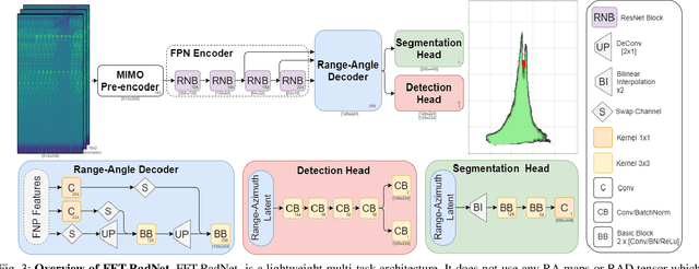
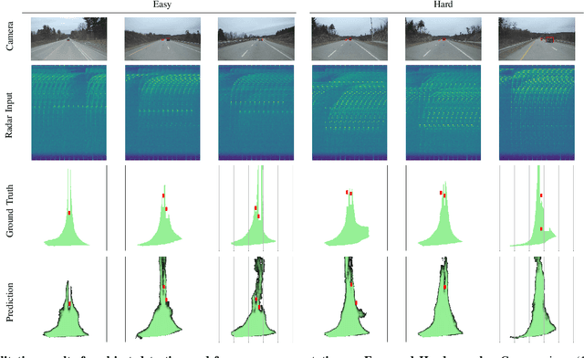
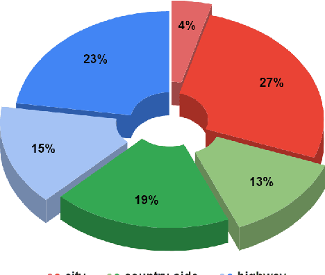
Abstract:With their robustness to adverse weather conditions and ability to measure speeds, radar sensors have been part of the automotive landscape for more than two decades. Recent progress toward High Definition (HD) Imaging radar has driven the angular resolution below the degree, thus approaching laser scanning performance. However, the amount of data a HD radar delivers and the computational cost to estimate the angular positions remain a challenge. In this paper, we propose a novel HD radar sensing model, FFT-RadNet, that eliminates the overhead of computing the Range-Azimuth-Doppler 3D tensor, learning instead to recover angles from a Range-Doppler spectrum. FFT-RadNet is trained both to detect vehicles and to segment free driving space. On both tasks, it competes with the most recent radar-based models while requiring less compute and memory. Also, we collected and annotated 2-hour worth of raw data from synchronized automotive-grade sensors (camera, laser, HD radar) in various environments (city street, highway, countryside road). This unique dataset, nick-named RADIal for "Radar, Lidar et al.", is available at https://github.com/valeoai/RADIal.
Multi-View Radar Semantic Segmentation
Mar 30, 2021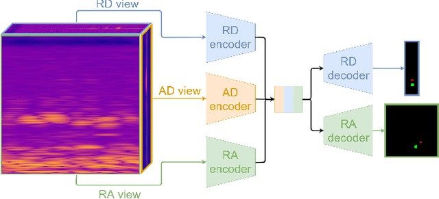
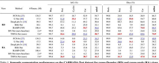
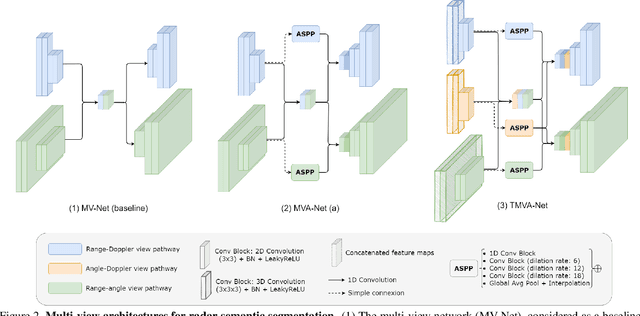
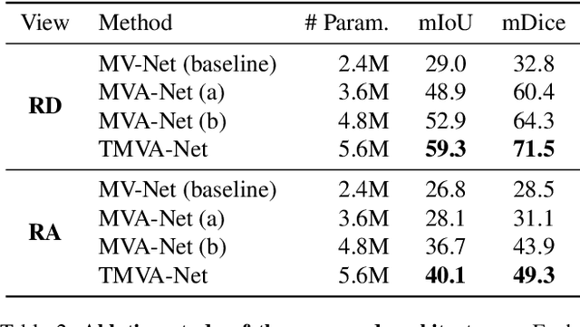
Abstract:Understanding the scene around the ego-vehicle is key to assisted and autonomous driving. Nowadays, this is mostly conducted using cameras and laser scanners, despite their reduced performances in adverse weather conditions. Automotive radars are low-cost active sensors that measure properties of surrounding objects, including their relative speed, and have the key advantage of not being impacted by rain, snow or fog. However, they are seldom used for scene understanding due to the size and complexity of radar raw data and the lack of annotated datasets. Fortunately, recent open-sourced datasets have opened up research on classification, object detection and semantic segmentation with raw radar signals using end-to-end trainable models. In this work, we propose several novel architectures, and their associated losses, which analyse multiple "views" of the range-angle-Doppler radar tensor to segment it semantically. Experiments conducted on the recent CARRADA dataset demonstrate that our best model outperforms alternative models, derived either from the semantic segmentation of natural images or from radar scene understanding, while requiring significantly fewer parameters. Both our code and trained models will be released.
 Add to Chrome
 Add to Firefox
 Add to Edge