Mélisande Teng
Bringing SAM to new heights: Leveraging elevation data for tree crown segmentation from drone imagery
Jun 05, 2025Abstract:Information on trees at the individual level is crucial for monitoring forest ecosystems and planning forest management. Current monitoring methods involve ground measurements, requiring extensive cost, time and labor. Advances in drone remote sensing and computer vision offer great potential for mapping individual trees from aerial imagery at broad-scale. Large pre-trained vision models, such as the Segment Anything Model (SAM), represent a particularly compelling choice given limited labeled data. In this work, we compare methods leveraging SAM for the task of automatic tree crown instance segmentation in high resolution drone imagery in three use cases: 1) boreal plantations, 2) temperate forests and 3) tropical forests. We also study the integration of elevation data into models, in the form of Digital Surface Model (DSM) information, which can readily be obtained at no additional cost from RGB drone imagery. We present BalSAM, a model leveraging SAM and DSM information, which shows potential over other methods, particularly in the context of plantations. We find that methods using SAM out-of-the-box do not outperform a custom Mask R-CNN, even with well-designed prompts. However, efficiently tuning SAM end-to-end and integrating DSM information are both promising avenues for tree crown instance segmentation models.
Assessing SAM for Tree Crown Instance Segmentation from Drone Imagery
Mar 26, 2025Abstract:The potential of tree planting as a natural climate solution is often undermined by inadequate monitoring of tree planting projects. Current monitoring methods involve measuring trees by hand for each species, requiring extensive cost, time, and labour. Advances in drone remote sensing and computer vision offer great potential for mapping and characterizing trees from aerial imagery, and large pre-trained vision models, such as the Segment Anything Model (SAM), may be a particularly compelling choice given limited labeled data. In this work, we compare SAM methods for the task of automatic tree crown instance segmentation in high resolution drone imagery of young tree plantations. We explore the potential of SAM for this task, and find that methods using SAM out-of-the-box do not outperform a custom Mask R-CNN, even with well-designed prompts, but that there is potential for methods which tune SAM further. We also show that predictions can be improved by adding Digital Surface Model (DSM) information as an input.
Predicting Species Occurrence Patterns from Partial Observations
Mar 28, 2024


Abstract:To address the interlinked biodiversity and climate crises, we need an understanding of where species occur and how these patterns are changing. However, observational data on most species remains very limited, and the amount of data available varies greatly between taxonomic groups. We introduce the problem of predicting species occurrence patterns given (a) satellite imagery, and (b) known information on the occurrence of other species. To evaluate algorithms on this task, we introduce SatButterfly, a dataset of satellite images, environmental data and observational data for butterflies, which is designed to pair with the existing SatBird dataset of bird observational data. To address this task, we propose a general model, R-Tran, for predicting species occurrence patterns that enables the use of partial observational data wherever found. We find that R-Tran outperforms other methods in predicting species encounter rates with partial information both within a taxon (birds) and across taxa (birds and butterflies). Our approach opens new perspectives to leveraging insights from species with abundant data to other species with scarce data, by modelling the ecosystems in which they co-occur.
SatBird: Bird Species Distribution Modeling with Remote Sensing and Citizen Science Data
Nov 02, 2023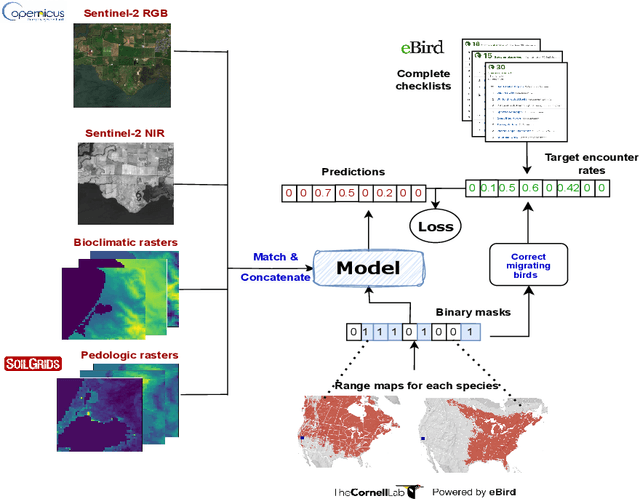


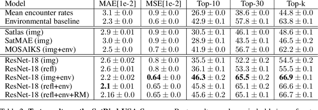
Abstract:Biodiversity is declining at an unprecedented rate, impacting ecosystem services necessary to ensure food, water, and human health and well-being. Understanding the distribution of species and their habitats is crucial for conservation policy planning. However, traditional methods in ecology for species distribution models (SDMs) generally focus either on narrow sets of species or narrow geographical areas and there remain significant knowledge gaps about the distribution of species. A major reason for this is the limited availability of data traditionally used, due to the prohibitive amount of effort and expertise required for traditional field monitoring. The wide availability of remote sensing data and the growing adoption of citizen science tools to collect species observations data at low cost offer an opportunity for improving biodiversity monitoring and enabling the modelling of complex ecosystems. We introduce a novel task for mapping bird species to their habitats by predicting species encounter rates from satellite images, and present SatBird, a satellite dataset of locations in the USA with labels derived from presence-absence observation data from the citizen science database eBird, considering summer (breeding) and winter seasons. We also provide a dataset in Kenya representing low-data regimes. We additionally provide environmental data and species range maps for each location. We benchmark a set of baselines on our dataset, including SOTA models for remote sensing tasks. SatBird opens up possibilities for scalably modelling properties of ecosystems worldwide.
Bird Distribution Modelling using Remote Sensing and Citizen Science data
May 01, 2023


Abstract:Climate change is a major driver of biodiversity loss, changing the geographic range and abundance of many species. However, there remain significant knowledge gaps about the distribution of species, due principally to the amount of effort and expertise required for traditional field monitoring. We propose an approach leveraging computer vision to improve species distribution modelling, combining the wide availability of remote sensing data with sparse on-ground citizen science data. We introduce a novel task and dataset for mapping US bird species to their habitats by predicting species encounter rates from satellite images, along with baseline models which demonstrate the power of our approach. Our methods open up possibilities for scalably modelling ecosystems properties worldwide.
ClimateGAN: Raising Climate Change Awareness by Generating Images of Floods
Oct 06, 2021

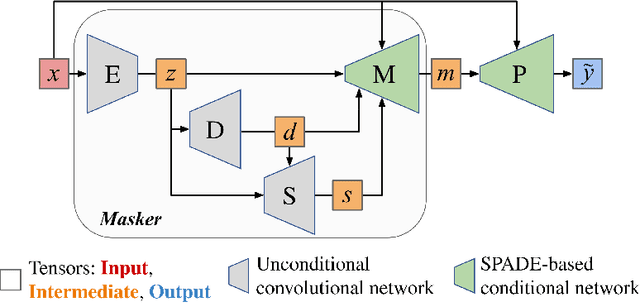
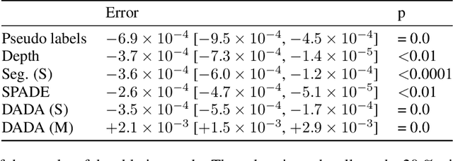
Abstract:Climate change is a major threat to humanity, and the actions required to prevent its catastrophic consequences include changes in both policy-making and individual behaviour. However, taking action requires understanding the effects of climate change, even though they may seem abstract and distant. Projecting the potential consequences of extreme climate events such as flooding in familiar places can help make the abstract impacts of climate change more concrete and encourage action. As part of a larger initiative to build a website that projects extreme climate events onto user-chosen photos, we present our solution to simulate photo-realistic floods on authentic images. To address this complex task in the absence of suitable training data, we propose ClimateGAN, a model that leverages both simulated and real data for unsupervised domain adaptation and conditional image generation. In this paper, we describe the details of our framework, thoroughly evaluate components of our architecture and demonstrate that our model is capable of robustly generating photo-realistic flooding.
Using Simulated Data to Generate Images of Climate Change
Jan 26, 2020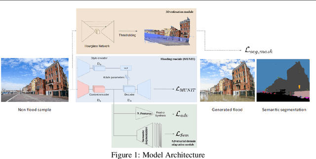
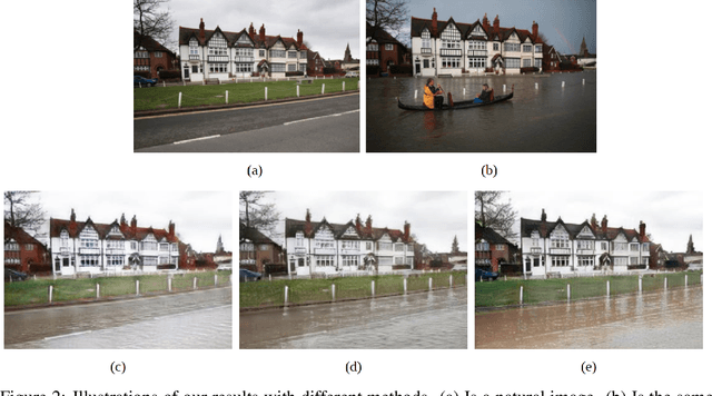
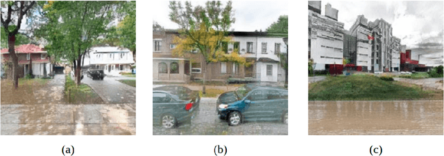

Abstract:Generative adversarial networks (GANs) used in domain adaptation tasks have the ability to generate images that are both realistic and personalized, transforming an input image while maintaining its identifiable characteristics. However, they often require a large quantity of training data to produce high-quality images in a robust way, which limits their usability in cases when access to data is limited. In our paper, we explore the potential of using images from a simulated 3D environment to improve a domain adaptation task carried out by the MUNIT architecture, aiming to use the resulting images to raise awareness of the potential future impacts of climate change.
 Add to Chrome
 Add to Firefox
 Add to Edge