Benjamin Akera
How much speech data is necessary for ASR in African languages? An evaluation of data scaling in Kinyarwanda and Kikuyu
Oct 08, 2025Abstract:The development of Automatic Speech Recognition (ASR) systems for low-resource African languages remains challenging due to limited transcribed speech data. While recent advances in large multilingual models like OpenAI's Whisper offer promising pathways for low-resource ASR development, critical questions persist regarding practical deployment requirements. This paper addresses two fundamental concerns for practitioners: determining the minimum data volumes needed for viable performance and characterizing the primary failure modes that emerge in production systems. We evaluate Whisper's performance through comprehensive experiments on two Bantu languages: systematic data scaling analysis on Kinyarwanda using training sets from 1 to 1,400 hours, and detailed error characterization on Kikuyu using 270 hours of training data. Our scaling experiments demonstrate that practical ASR performance (WER < 13\%) becomes achievable with as little as 50 hours of training data, with substantial improvements continuing through 200 hours (WER < 10\%). Complementing these volume-focused findings, our error analysis reveals that data quality issues, particularly noisy ground truth transcriptions, account for 38.6\% of high-error cases, indicating that careful data curation is as critical as data volume for robust system performance. These results provide actionable benchmarks and deployment guidance for teams developing ASR systems across similar low-resource language contexts. We release accompanying and models see https://github.com/SunbirdAI/kinyarwanda-whisper-eval
Sunflower: A New Approach To Expanding Coverage of African Languages in Large Language Models
Oct 08, 2025Abstract:There are more than 2000 living languages in Africa, most of which have been bypassed by advances in language technology. Current leading LLMs exhibit strong performance on a number of the most common languages (e.g. Swahili or Yoruba), but prioritise support for the languages with the most speakers first, resulting in piecemeal ability across disparate languages. We contend that a regionally focussed approach is more efficient, and present a case study for Uganda, a country with high linguistic diversity. We describe the development of Sunflower 14B and 32B, a pair of models based on Qwen 3 with state of the art comprehension in the majority of all Ugandan languages. These models are open source and can be used to reduce language barriers in a number of important practical applications.
SatBird: Bird Species Distribution Modeling with Remote Sensing and Citizen Science Data
Nov 02, 2023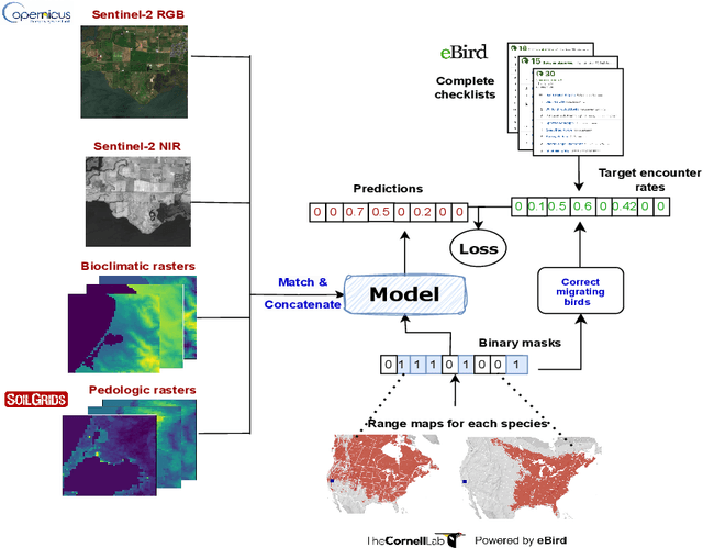


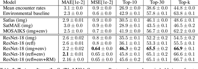
Abstract:Biodiversity is declining at an unprecedented rate, impacting ecosystem services necessary to ensure food, water, and human health and well-being. Understanding the distribution of species and their habitats is crucial for conservation policy planning. However, traditional methods in ecology for species distribution models (SDMs) generally focus either on narrow sets of species or narrow geographical areas and there remain significant knowledge gaps about the distribution of species. A major reason for this is the limited availability of data traditionally used, due to the prohibitive amount of effort and expertise required for traditional field monitoring. The wide availability of remote sensing data and the growing adoption of citizen science tools to collect species observations data at low cost offer an opportunity for improving biodiversity monitoring and enabling the modelling of complex ecosystems. We introduce a novel task for mapping bird species to their habitats by predicting species encounter rates from satellite images, and present SatBird, a satellite dataset of locations in the USA with labels derived from presence-absence observation data from the citizen science database eBird, considering summer (breeding) and winter seasons. We also provide a dataset in Kenya representing low-data regimes. We additionally provide environmental data and species range maps for each location. We benchmark a set of baselines on our dataset, including SOTA models for remote sensing tasks. SatBird opens up possibilities for scalably modelling properties of ecosystems worldwide.
Bird Distribution Modelling using Remote Sensing and Citizen Science data
May 01, 2023


Abstract:Climate change is a major driver of biodiversity loss, changing the geographic range and abundance of many species. However, there remain significant knowledge gaps about the distribution of species, due principally to the amount of effort and expertise required for traditional field monitoring. We propose an approach leveraging computer vision to improve species distribution modelling, combining the wide availability of remote sensing data with sparse on-ground citizen science data. We introduce a novel task and dataset for mapping US bird species to their habitats by predicting species encounter rates from satellite images, along with baseline models which demonstrate the power of our approach. Our methods open up possibilities for scalably modelling ecosystems properties worldwide.
hBert + BiasCorp -- Fighting Racism on the Web
Apr 06, 2021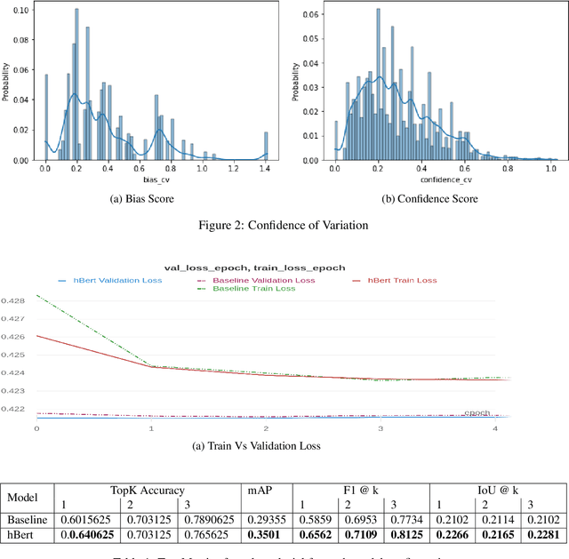
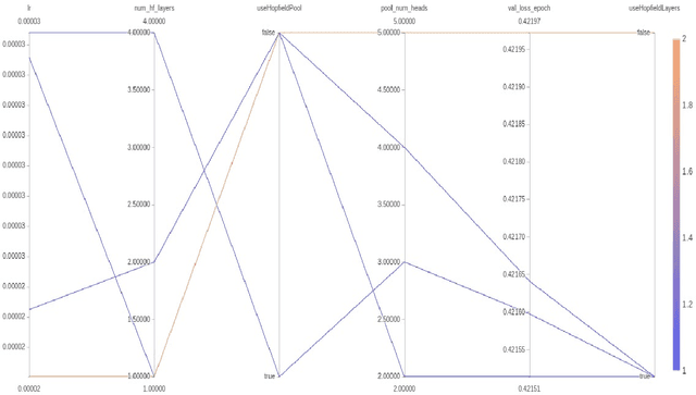
Abstract:Subtle and overt racism is still present both in physical and online communities today and has impacted many lives in different segments of the society. In this short piece of work, we present how we're tackling this societal issue with Natural Language Processing. We are releasing BiasCorp, a dataset containing 139,090 comments and news segment from three specific sources - Fox News, BreitbartNews and YouTube. The first batch (45,000 manually annotated) is ready for publication. We are currently in the final phase of manually labeling the remaining dataset using Amazon Mechanical Turk. BERT has been used widely in several downstream tasks. In this work, we present hBERT, where we modify certain layers of the pretrained BERT model with the new Hopfield Layer. hBert generalizes well across different distributions with the added advantage of a reduced model complexity. We are also releasing a JavaScript library and a Chrome Extension Application, to help developers make use of our trained model in web applications (say chat application) and for users to identify and report racially biased contents on the web respectively.
Machine Learning for Glacier Monitoring in the Hindu Kush Himalaya
Dec 09, 2020

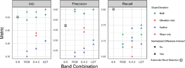
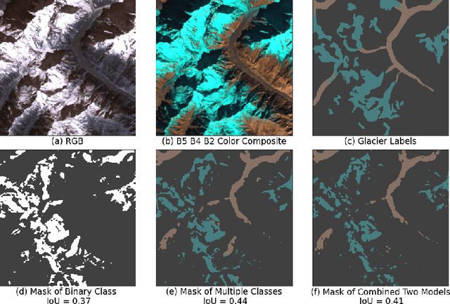
Abstract:Glacier mapping is key to ecological monitoring in the hkh region. Climate change poses a risk to individuals whose livelihoods depend on the health of glacier ecosystems. In this work, we present a machine learning based approach to support ecological monitoring, with a focus on glaciers. Our approach is based on semi-automated mapping from satellite images. We utilize readily available remote sensing data to create a model to identify and outline both clean ice and debris-covered glaciers from satellite imagery. We also release data and develop a web tool that allows experts to visualize and correct model predictions, with the ultimate aim of accelerating the glacier mapping process.
Scoring Root Necrosis in Cassava Using Semantic Segmentation
May 07, 2020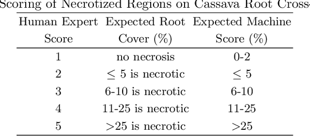
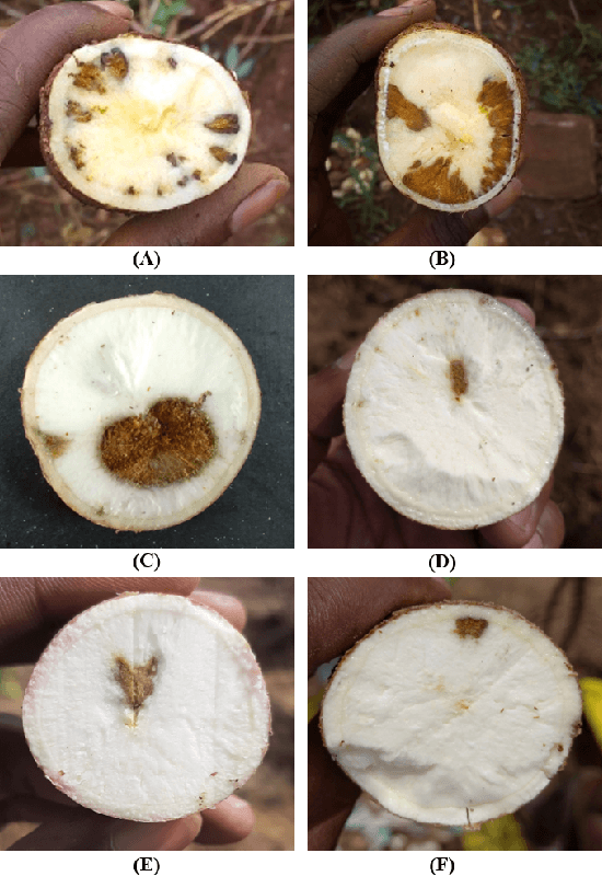
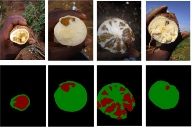
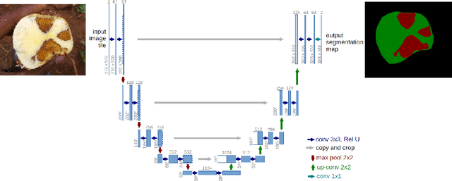
Abstract:Cassava a major food crop in many parts of Africa, has majorly been affected by Cassava Brown Streak Disease (CBSD). The disease affects tuberous roots and presents symptoms that include a yellow/brown, dry, corky necrosis within the starch-bearing tissues. Cassava breeders currently depend on visual inspection to score necrosis in roots based on a qualitative score which is quite subjective. In this paper we present an approach to automate root necrosis scoring using deep convolutional neural networks with semantic segmentation. Our experiments show that the UNet model performs this task with high accuracy achieving a mean Intersection over Union (IoU) of 0.90 on the test set. This method provides a means to use a quantitative measure for necrosis scoring on root cross-sections. This is done by segmentation and classifying the necrotized and non-necrotized pixels of cassava root cross-sections without any additional feature engineering.
Keyword Spotter Model for Crop Pest and Disease Monitoring from Community Radio Data
Oct 05, 2019

Abstract:In societies with well developed internet infrastructure, social media is the leading medium of communication for various social issues especially for breaking news situations. In rural Uganda however, public community radio is still a dominant means for news dissemination. Community radio gives audience to the general public especially to individuals living in rural areas, and thus plays an important role in giving a voice to those living in the broadcast area. It is an avenue for participatory communication and a tool relevant in both economic and social development.This is supported by the rise to ubiquity of mobile phones providing access to phone-in or text-in talk shows. In this paper, we describe an approach to analysing the readily available community radio data with machine learning-based speech keyword spotting techniques. We identify the keywords of interest related to agriculture and build models to automatically identify these keywords from audio streams. Our contribution through these techniques is a cost-efficient and effective way to monitor food security concerns particularly in rural areas. Through keyword spotting and radio talk show analysis, issues such as crop diseases, pests, drought and famine can be captured and fed into an early warning system for stakeholders and policy makers.
 Add to Chrome
 Add to Firefox
 Add to Edge