Maria Sdraka
Magnifying change: Rapid burn scar mapping with multi-resolution, multi-source satellite imagery
Jan 14, 2026Abstract:Delineating wildfire affected areas using satellite imagery remains challenging due to irregular and spatially heterogeneous spectral changes across the electromagnetic spectrum. While recent deep learning approaches achieve high accuracy when high-resolution multispectral data are available, their applicability in operational settings, where a quick delineation of the burn scar shortly after a wildfire incident is required, is limited by the trade-off between spatial resolution and temporal revisit frequency of current satellite systems. To address this limitation, we propose a novel deep learning model, namely BAM-MRCD, which employs multi-resolution, multi-source satellite imagery (MODIS and Sentinel-2) for the timely production of detailed burnt area maps with high spatial and temporal resolution. Our model manages to detect even small scale wildfires with high accuracy, surpassing similar change detection models as well as solid baselines. All data and code are available in the GitHub repository: https://github.com/Orion-AI-Lab/BAM-MRCD.
Hephaestus Minicubes: A Global, Multi-Modal Dataset for Volcanic Unrest Monitoring
May 23, 2025Abstract:Ground deformation is regarded in volcanology as a key precursor signal preceding volcanic eruptions. Satellite-based Interferometric Synthetic Aperture Radar (InSAR) enables consistent, global-scale deformation tracking; however, deep learning methods remain largely unexplored in this domain, mainly due to the lack of a curated machine learning dataset. In this work, we build on the existing Hephaestus dataset, and introduce Hephaestus Minicubes, a global collection of 38 spatiotemporal datacubes offering high resolution, multi-source and multi-temporal information, covering 44 of the world's most active volcanoes over a 7-year period. Each spatiotemporal datacube integrates InSAR products, topographic data, as well as atmospheric variables which are known to introduce signal delays that can mimic ground deformation in InSAR imagery. Furthermore, we provide expert annotations detailing the type, intensity and spatial extent of deformation events, along with rich text descriptions of the observed scenes. Finally, we present a comprehensive benchmark, demonstrating Hephaestus Minicubes' ability to support volcanic unrest monitoring as a multi-modal, multi-temporal classification and semantic segmentation task, establishing strong baselines with state-of-the-art architectures. This work aims to advance machine learning research in volcanic monitoring, contributing to the growing integration of data-driven methods within Earth science applications.
Kuro Siwo: 12.1 billion $m^2$ under the water. A global multi-temporal satellite dataset for rapid flood mapping
Nov 18, 2023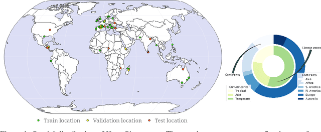

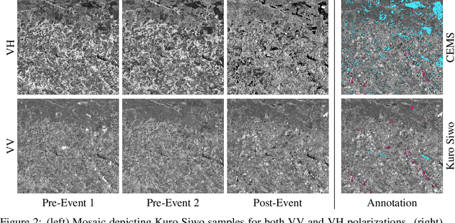
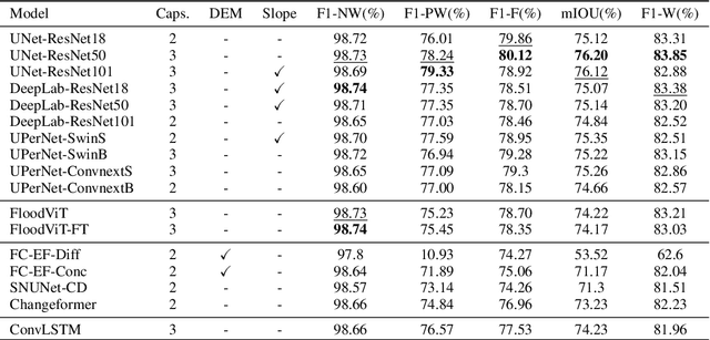
Abstract:Global floods, exacerbated by climate change, pose severe threats to human life, infrastructure, and the environment. This urgency is highlighted by recent catastrophic events in Pakistan and New Zealand, underlining the critical need for precise flood mapping for guiding restoration efforts, understanding vulnerabilities, and preparing for future events. While Synthetic Aperture Radar (SAR) offers day-and-night, all-weather imaging capabilities, harnessing it for deep learning is hindered by the absence of a large annotated dataset. To bridge this gap, we introduce Kuro Siwo, a meticulously curated multi-temporal dataset, spanning 32 flood events globally. Our dataset maps more than 63 billion m2 of land, with 12.1 billion of them being either a flooded area or a permanent water body. Kuro Siwo stands out for its unparalleled annotation quality to facilitate rapid flood mapping in a supervised setting. We also augment learning by including a large unlabeled set of SAR samples, aimed at self-supervised pretraining. We provide an extensive benchmark and strong baselines for a diverse set of flood events from Europe, America, Africa and Australia. Our benchmark demonstrates the quality of Kuro Siwo annotations, training models that can achieve $\approx$ 85% and $\approx$ 87% in F1-score for flooded areas and general water detection respectively. This work calls on the deep learning community to develop solution-driven algorithms for rapid flood mapping, with the potential to aid civil protection and humanitarian agencies amid climate change challenges. Our code and data will be made available at https://github.com/Orion-AI-Lab/KuroSiwo
FLOGA: A machine learning ready dataset, a benchmark and a novel deep learning model for burnt area mapping with Sentinel-2
Nov 06, 2023


Abstract:Over the last decade there has been an increasing frequency and intensity of wildfires across the globe, posing significant threats to human and animal lives, ecosystems, and socio-economic stability. Therefore urgent action is required to mitigate their devastating impact and safeguard Earth's natural resources. Robust Machine Learning methods combined with the abundance of high-resolution satellite imagery can provide accurate and timely mappings of the affected area in order to assess the scale of the event, identify the impacted assets and prioritize and allocate resources effectively for the proper restoration of the damaged region. In this work, we create and introduce a machine-learning ready dataset we name FLOGA (Forest wiLdfire Observations for the Greek Area). This dataset is unique as it comprises of satellite imagery acquired before and after a wildfire event, it contains information from Sentinel-2 and MODIS modalities with variable spatial and spectral resolution, and contains a large number of events where the corresponding burnt area ground truth has been annotated by domain experts. FLOGA covers the wider region of Greece, which is characterized by a Mediterranean landscape and climatic conditions. We use FLOGA to provide a thorough comparison of multiple Machine Learning and Deep Learning algorithms for the automatic extraction of burnt areas, approached as a change detection task. We also compare the results to those obtained using standard specialized spectral indices for burnt area mapping. Finally, we propose a novel Deep Learning model, namely BAM-CD. Our benchmark results demonstrate the efficacy of the proposed technique in the automatic extraction of burnt areas, outperforming all other methods in terms of accuracy and robustness. Our dataset and code are publicly available at: https://github.com/Orion-AI-Lab/FLOGA.
A Sentinel-2 multi-year, multi-country benchmark dataset for crop classification and segmentation with deep learning
Apr 02, 2022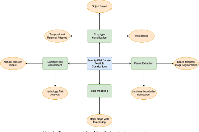
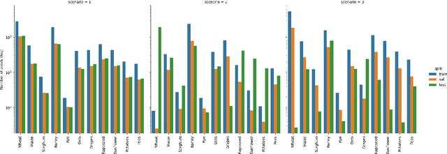
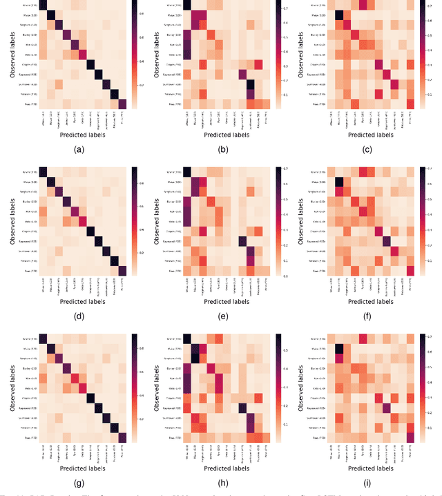
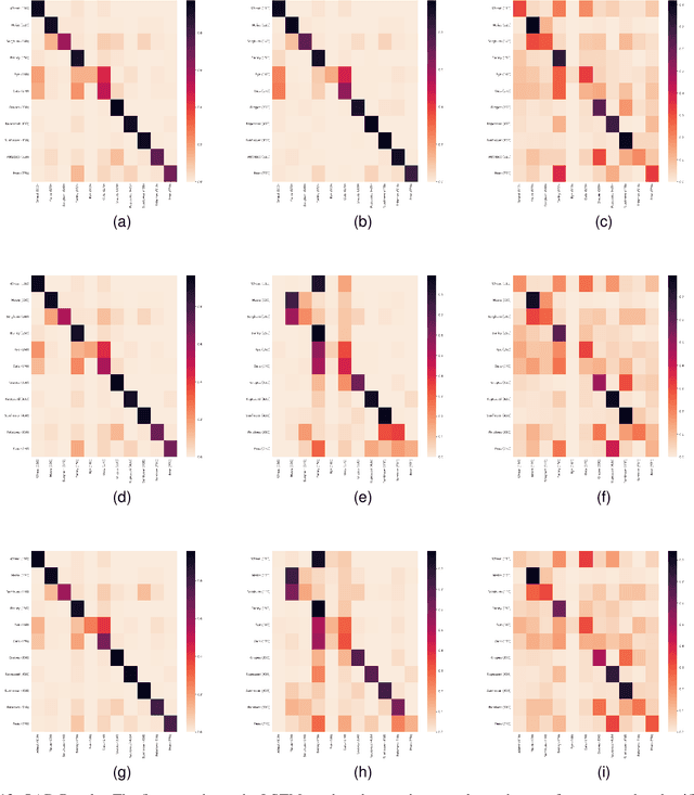
Abstract:In this work we introduce Sen4AgriNet, a Sentinel-2 based time series multi country benchmark dataset, tailored for agricultural monitoring applications with Machine and Deep Learning. Sen4AgriNet dataset is annotated from farmer declarations collected via the Land Parcel Identification System (LPIS) for harmonizing country wide labels. These declarations have only recently been made available as open data, allowing for the first time the labeling of satellite imagery from ground truth data. We proceed to propose and standardise a new crop type taxonomy across Europe that address Common Agriculture Policy (CAP) needs, based on the Food and Agriculture Organization (FAO) Indicative Crop Classification scheme. Sen4AgriNet is the only multi-country, multi-year dataset that includes all spectral information. It is constructed to cover the period 2016-2020 for Catalonia and France, while it can be extended to include additional countries. Currently, it contains 42.5 million parcels, which makes it significantly larger than other available archives. We extract two sub-datasets to highlight its value for diverse Deep Learning applications; the Object Aggregated Dataset (OAD) and the Patches Assembled Dataset (PAD). OAD capitalizes zonal statistics of each parcel, thus creating a powerful label-to-features instance for classification algorithms. On the other hand, PAD structure generalizes the classification problem to parcel extraction and semantic segmentation and labeling. The PAD and OAD are examined under three different scenarios to showcase and model the effects of spatial and temporal variability across different years and different countries.
 Add to Chrome
 Add to Firefox
 Add to Edge