Ilektra Karasante
Causal Graph Neural Networks for Wildfire Danger Prediction
Mar 13, 2024


Abstract:Wildfire forecasting is notoriously hard due to the complex interplay of different factors such as weather conditions, vegetation types and human activities. Deep learning models show promise in dealing with this complexity by learning directly from data. However, to inform critical decision making, we argue that we need models that are right for the right reasons; that is, the implicit rules learned should be grounded by the underlying processes driving wildfires. In that direction, we propose integrating causality with Graph Neural Networks (GNNs) that explicitly model the causal mechanism among complex variables via graph learning. The causal adjacency matrix considers the synergistic effect among variables and removes the spurious links from highly correlated impacts. Our methodology's effectiveness is demonstrated through superior performance forecasting wildfire patterns in the European boreal and mediterranean biome. The gain is especially prominent in a highly imbalanced dataset, showcasing an enhanced robustness of the model to adapt to regime shifts in functional relationships. Furthermore, SHAP values from our trained model further enhance our understanding of the model's inner workings.
SeasFire as a Multivariate Earth System Datacube for Wildfire Dynamics
Dec 22, 2023


Abstract:The global occurrence, scale, and frequency of wildfires pose significant threats to ecosystem services and human livelihoods. To effectively quantify and attribute the antecedent conditions for wildfires, a thorough understanding of Earth system dynamics is imperative. In response, we introduce the SeasFire datacube, a meticulously curated spatiotemporal dataset tailored for global sub-seasonal to seasonal wildfire modeling via Earth observation. The SeasFire datacube comprises of 59 variables encompassing climate, vegetation, oceanic indices, and human factors, has an 8-day temporal resolution and a spatial resolution of 0.25$^{\circ}$, and spans from 2001 to 2021. We showcase the versatility of SeasFire for exploring the variability and seasonality of wildfire drivers, modeling causal links between ocean-climate teleconnections and wildfires, and predicting sub-seasonal wildfire patterns across multiple timescales with a Deep Learning model. We publicly release the SeasFire datacube and appeal to Earth system scientists and Machine Learning practitioners to use it for an improved understanding and anticipation of wildfires.
Kuro Siwo: 12.1 billion $m^2$ under the water. A global multi-temporal satellite dataset for rapid flood mapping
Nov 18, 2023


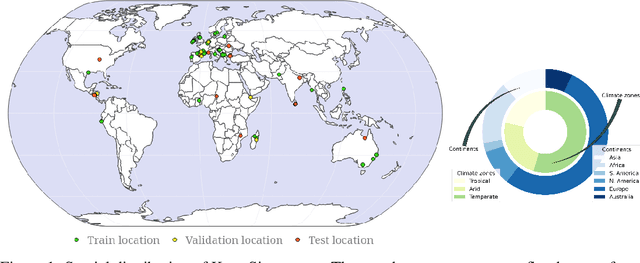
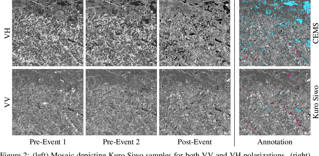
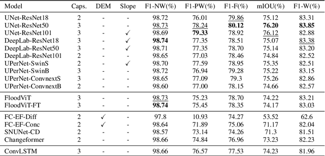
Abstract:Global floods, exacerbated by climate change, pose severe threats to human life, infrastructure, and the environment. This urgency is highlighted by recent catastrophic events in Pakistan and New Zealand, underlining the critical need for precise flood mapping for guiding restoration efforts, understanding vulnerabilities, and preparing for future events. While Synthetic Aperture Radar (SAR) offers day-and-night, all-weather imaging capabilities, harnessing it for deep learning is hindered by the absence of a large annotated dataset. To bridge this gap, we introduce Kuro Siwo, a meticulously curated multi-temporal dataset, spanning 32 flood events globally. Our dataset maps more than 63 billion m2 of land, with 12.1 billion of them being either a flooded area or a permanent water body. Kuro Siwo stands out for its unparalleled annotation quality to facilitate rapid flood mapping in a supervised setting. We also augment learning by including a large unlabeled set of SAR samples, aimed at self-supervised pretraining. We provide an extensive benchmark and strong baselines for a diverse set of flood events from Europe, America, Africa and Australia. Our benchmark demonstrates the quality of Kuro Siwo annotations, training models that can achieve $\approx$ 85% and $\approx$ 87% in F1-score for flooded areas and general water detection respectively. This work calls on the deep learning community to develop solution-driven algorithms for rapid flood mapping, with the potential to aid civil protection and humanitarian agencies amid climate change challenges. Our code and data will be made available at https://github.com/Orion-AI-Lab/KuroSiwo
Deep Learning for Global Wildfire Forecasting
Nov 06, 2022


Abstract:Climate change is expected to aggravate wildfire activity through the exacerbation of fire weather. Improving our capabilities to anticipate wildfires on a global scale is of uttermost importance for mitigating their negative effects. In this work, we create a global fire dataset and demonstrate a prototype for predicting the presence of global burned areas on a sub-seasonal scale with the use of segmentation deep learning models. Particularly, we present an open-access global analysis-ready datacube, which contains a variety of variables related to the seasonal and sub-seasonal fire drivers (climate, vegetation, oceanic indices, human-related variables), as well as the historical burned areas and wildfire emissions for 2001-2021. We train a deep learning model, which treats global wildfire forecasting as an image segmentation task and skillfully predicts the presence of burned areas 8, 16, 32 and 64 days ahead of time. Our work motivates the use of deep learning for global burned area forecasting and paves the way towards improved anticipation of global wildfire patterns.
 Add to Chrome
 Add to Firefox
 Add to Edge