Spyros Kondylatos
Wildfire spread forecasting with Deep Learning
May 23, 2025Abstract:Accurate prediction of wildfire spread is crucial for effective risk management, emergency response, and strategic resource allocation. In this study, we present a deep learning (DL)-based framework for forecasting the final extent of burned areas, using data available at the time of ignition. We leverage a spatio-temporal dataset that covers the Mediterranean region from 2006 to 2022, incorporating remote sensing data, meteorological observations, vegetation maps, land cover classifications, anthropogenic factors, topography data, and thermal anomalies. To evaluate the influence of temporal context, we conduct an ablation study examining how the inclusion of pre- and post-ignition data affects model performance, benchmarking the temporal-aware DL models against a baseline trained exclusively on ignition-day inputs. Our results indicate that multi-day observational data substantially improve predictive accuracy. Particularly, the best-performing model, incorporating a temporal window of four days before to five days after ignition, improves both the F1 score and the Intersection over Union by almost 5% in comparison to the baseline on the test dataset. We publicly release our dataset and models to enhance research into data-driven approaches for wildfire modeling and response.
Probabilistic Machine Learning for Noisy Labels in Earth Observation
Apr 04, 2025Abstract:Label noise poses a significant challenge in Earth Observation (EO), often degrading the performance and reliability of supervised Machine Learning (ML) models. Yet, given the critical nature of several EO applications, developing robust and trustworthy ML solutions is essential. In this study, we take a step in this direction by leveraging probabilistic ML to model input-dependent label noise and quantify data uncertainty in EO tasks, accounting for the unique noise sources inherent in the domain. We train uncertainty-aware probabilistic models across a broad range of high-impact EO applications-spanning diverse noise sources, input modalities, and ML configurations-and introduce a dedicated pipeline to assess their accuracy and reliability. Our experimental results show that the uncertainty-aware models consistently outperform the standard deterministic approaches across most datasets and evaluation metrics. Moreover, through rigorous uncertainty evaluation, we validate the reliability of the predicted uncertainty estimates, enhancing the interpretability of model predictions. Our findings emphasize the importance of modeling label noise and incorporating uncertainty quantification in EO, paving the way for more accurate, reliable, and trustworthy ML solutions in the field.
On the Generalization of Representation Uncertainty in Earth Observation
Mar 10, 2025Abstract:Recent advances in Computer Vision have introduced the concept of pretrained representation uncertainty, enabling zero-shot uncertainty estimation. This holds significant potential for Earth Observation (EO), where trustworthiness is critical, yet the complexity of EO data poses challenges to uncertainty-aware methods. In this work, we investigate the generalization of representation uncertainty in EO, considering the domain's unique semantic characteristics. We pretrain uncertainties on large EO datasets and propose an evaluation framework to assess their zero-shot performance in multi-label classification and segmentation EO tasks. Our findings reveal that, unlike uncertainties pretrained on natural images, EO-pretraining exhibits strong generalization across unseen EO domains, geographic locations, and target granularities, while maintaining sensitivity to variations in ground sampling distance. We demonstrate the practical utility of pretrained uncertainties showcasing their alignment with task-specific uncertainties in downstream tasks, their sensitivity to real-world EO image noise, and their ability to generate spatial uncertainty estimates out-of-the-box. Initiating the discussion on representation uncertainty in EO, our study provides insights into its strengths and limitations, paving the way for future research in the field. Code and weights are available at: https://github.com/Orion-AI-Lab/EOUncertaintyGeneralization.
FireCastNet: Earth-as-a-Graph for Seasonal Fire Prediction
Feb 03, 2025


Abstract:With climate change expected to exacerbate fire weather conditions, the accurate and timely anticipation of wildfires becomes increasingly crucial for disaster mitigation. In this study, we utilize SeasFire, a comprehensive global wildfire dataset with climate, vegetation, oceanic indices, and human-related variables, to enable seasonal wildfire forecasting with machine learning. For the predictive analysis, we present FireCastNet, a novel architecture which combines a 3D convolutional encoder with GraphCast, originally developed for global short-term weather forecasting using graph neural networks. FireCastNet is trained to capture the context leading to wildfires, at different spatial and temporal scales. Our investigation focuses on assessing the effectiveness of our model in predicting the presence of burned areas at varying forecasting time horizons globally, extending up to six months into the future, and on how different spatial or/and temporal context affects the performance. Our findings demonstrate the potential of deep learning models in seasonal fire forecasting; longer input time-series leads to more robust predictions, while integrating spatial information to capture wildfire spatio-temporal dynamics boosts performance. Finally, our results hint that in order to enhance performance at longer forecasting horizons, a larger receptive field spatially needs to be considered.
AI for Extreme Event Modeling and Understanding: Methodologies and Challenges
Jun 28, 2024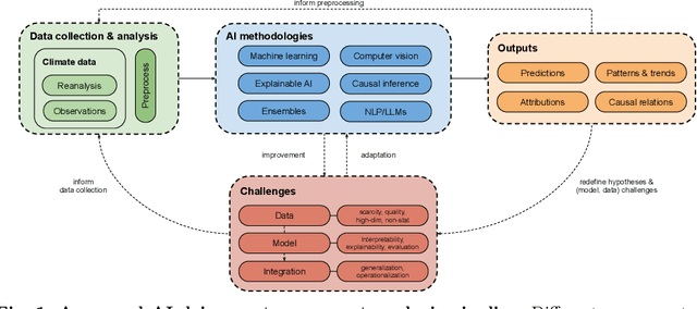

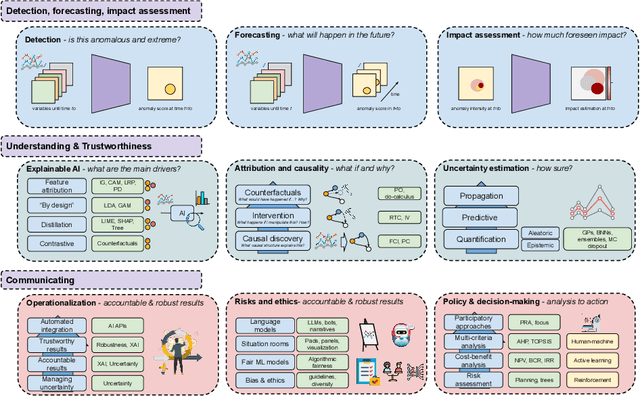

Abstract:In recent years, artificial intelligence (AI) has deeply impacted various fields, including Earth system sciences. Here, AI improved weather forecasting, model emulation, parameter estimation, and the prediction of extreme events. However, the latter comes with specific challenges, such as developing accurate predictors from noisy, heterogeneous and limited annotated data. This paper reviews how AI is being used to analyze extreme events (like floods, droughts, wildfires and heatwaves), highlighting the importance of creating accurate, transparent, and reliable AI models. We discuss the hurdles of dealing with limited data, integrating information in real-time, deploying models, and making them understandable, all crucial for gaining the trust of stakeholders and meeting regulatory needs. We provide an overview of how AI can help identify and explain extreme events more effectively, improving disaster response and communication. We emphasize the need for collaboration across different fields to create AI solutions that are practical, understandable, and trustworthy for analyzing and predicting extreme events. Such collaborative efforts aim to enhance disaster readiness and disaster risk reduction.
Seasonal Fire Prediction using Spatio-Temporal Deep Neural Networks
Apr 09, 2024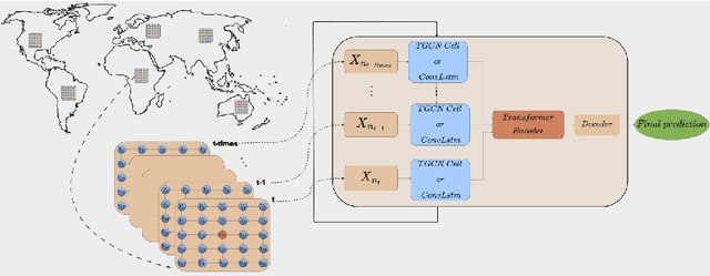

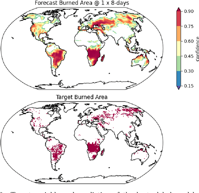

Abstract:With climate change expected to exacerbate fire weather conditions, the accurate anticipation of wildfires on a global scale becomes increasingly crucial for disaster mitigation. In this study, we utilize SeasFire, a comprehensive global wildfire dataset with climate, vegetation, oceanic indices, and human-related variables, to enable seasonal wildfire forecasting with machine learning. For the predictive analysis, we train deep learning models with different architectures that capture the spatio-temporal context leading to wildfires. Our investigation focuses on assessing the effectiveness of these models in predicting the presence of burned areas at varying forecasting time horizons globally, extending up to six months into the future, and on how different spatial or/and temporal context affects the performance of the models. Our findings demonstrate the great potential of deep learning models in seasonal fire forecasting; longer input time-series leads to more robust predictions across varying forecasting horizons, while integrating spatial information to capture wildfire spatio-temporal dynamics boosts performance. Finally, our results hint that in order to enhance performance at longer forecasting horizons, a larger receptive field spatially needs to be considered.
TeleViT: Teleconnection-driven Transformers Improve Subseasonal to Seasonal Wildfire Forecasting
Jun 19, 2023Abstract:Wildfires are increasingly exacerbated as a result of climate change, necessitating advanced proactive measures for effective mitigation. It is important to forecast wildfires weeks and months in advance to plan forest fuel management, resource procurement and allocation. To achieve such accurate long-term forecasts at a global scale, it is crucial to employ models that account for the Earth system's inherent spatio-temporal interactions, such as memory effects and teleconnections. We propose a teleconnection-driven vision transformer (TeleViT), capable of treating the Earth as one interconnected system, integrating fine-grained local-scale inputs with global-scale inputs, such as climate indices and coarse-grained global variables. Through comprehensive experimentation, we demonstrate the superiority of TeleViT in accurately predicting global burned area patterns for various forecasting windows, up to four months in advance. The gain is especially pronounced in larger forecasting windows, demonstrating the improved ability of deep learning models that exploit teleconnections to capture Earth system dynamics. Code available at https://github.com/Orion-Ai-Lab/TeleViT.
Mesogeos: A multi-purpose dataset for data-driven wildfire modeling in the Mediterranean
Jun 08, 2023Abstract:We introduce Mesogeos, a large-scale multi-purpose dataset for wildfire modeling in the Mediterranean. Mesogeos integrates variables representing wildfire drivers (meteorology, vegetation, human activity) and historical records of wildfire ignitions and burned areas for 17 years (2006-2022). It is designed as a cloud-friendly spatio-temporal dataset, namely a datacube, harmonizing all variables in a grid of 1km x 1km x 1-day resolution. The datacube structure offers opportunities to assess machine learning (ML) usage in various wildfire modeling tasks. We extract two ML-ready datasets that establish distinct tracks to demonstrate this potential: (1) short-term wildfire danger forecasting and (2) final burned area estimation given the point of ignition. We define appropriate metrics and baselines to evaluate the performance of models in each track. By publishing the datacube, along with the code to create the ML datasets and models, we encourage the community to foster the implementation of additional tracks for mitigating the increasing threat of wildfires in the Mediterranean.
Deep Learning for Global Wildfire Forecasting
Nov 06, 2022


Abstract:Climate change is expected to aggravate wildfire activity through the exacerbation of fire weather. Improving our capabilities to anticipate wildfires on a global scale is of uttermost importance for mitigating their negative effects. In this work, we create a global fire dataset and demonstrate a prototype for predicting the presence of global burned areas on a sub-seasonal scale with the use of segmentation deep learning models. Particularly, we present an open-access global analysis-ready datacube, which contains a variety of variables related to the seasonal and sub-seasonal fire drivers (climate, vegetation, oceanic indices, human-related variables), as well as the historical burned areas and wildfire emissions for 2001-2021. We train a deep learning model, which treats global wildfire forecasting as an image segmentation task and skillfully predicts the presence of burned areas 8, 16, 32 and 64 days ahead of time. Our work motivates the use of deep learning for global burned area forecasting and paves the way towards improved anticipation of global wildfire patterns.
Deep Learning Methods for Daily Wildfire Danger Forecasting
Nov 04, 2021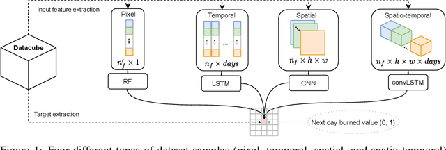

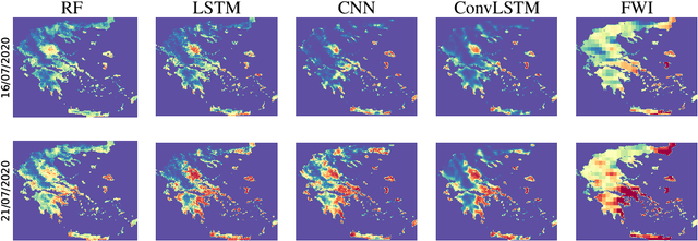
Abstract:Wildfire forecasting is of paramount importance for disaster risk reduction and environmental sustainability. We approach daily fire danger prediction as a machine learning task, using historical Earth observation data from the last decade to predict next-day's fire danger. To that end, we collect, pre-process and harmonize an open-access datacube, featuring a set of covariates that jointly affect the fire occurrence and spread, such as weather conditions, satellite-derived products, topography features and variables related to human activity. We implement a variety of Deep Learning (DL) models to capture the spatial, temporal or spatio-temporal context and compare them against a Random Forest (RF) baseline. We find that either spatial or temporal context is enough to surpass the RF, while a ConvLSTM that exploits the spatio-temporal context performs best with a test Area Under the Receiver Operating Characteristic of 0.926. Our DL-based proof-of-concept provides national-scale daily fire danger maps at a much higher spatial resolution than existing operational solutions.
 Add to Chrome
 Add to Firefox
 Add to Edge