Nuno Carvalhais
Double machine learning for causal hybrid modeling -- applications in the Earth sciences
Feb 20, 2024Abstract:Hybrid modeling integrates machine learning with scientific knowledge with the goal of enhancing interpretability, generalization, and adherence to natural laws. Nevertheless, equifinality and regularization biases pose challenges in hybrid modeling to achieve these purposes. This paper introduces a novel approach to estimating hybrid models via a causal inference framework, specifically employing Double Machine Learning (DML) to estimate causal effects. We showcase its use for the Earth sciences on two problems related to carbon dioxide fluxes. In the $Q_{10}$ model, we demonstrate that DML-based hybrid modeling is superior in estimating causal parameters over end-to-end deep neural network (DNN) approaches, proving efficiency, robustness to bias from regularization methods, and circumventing equifinality. Our approach, applied to carbon flux partitioning, exhibits flexibility in accommodating heterogeneous causal effects. The study emphasizes the necessity of explicitly defining causal graphs and relationships, advocating for this as a general best practice. We encourage the continued exploration of causality in hybrid models for more interpretable and trustworthy results in knowledge-guided machine learning.
SeasFire as a Multivariate Earth System Datacube for Wildfire Dynamics
Dec 22, 2023


Abstract:The global occurrence, scale, and frequency of wildfires pose significant threats to ecosystem services and human livelihoods. To effectively quantify and attribute the antecedent conditions for wildfires, a thorough understanding of Earth system dynamics is imperative. In response, we introduce the SeasFire datacube, a meticulously curated spatiotemporal dataset tailored for global sub-seasonal to seasonal wildfire modeling via Earth observation. The SeasFire datacube comprises of 59 variables encompassing climate, vegetation, oceanic indices, and human factors, has an 8-day temporal resolution and a spatial resolution of 0.25$^{\circ}$, and spans from 2001 to 2021. We showcase the versatility of SeasFire for exploring the variability and seasonality of wildfire drivers, modeling causal links between ocean-climate teleconnections and wildfires, and predicting sub-seasonal wildfire patterns across multiple timescales with a Deep Learning model. We publicly release the SeasFire datacube and appeal to Earth system scientists and Machine Learning practitioners to use it for an improved understanding and anticipation of wildfires.
Deep Learning for Global Wildfire Forecasting
Nov 06, 2022


Abstract:Climate change is expected to aggravate wildfire activity through the exacerbation of fire weather. Improving our capabilities to anticipate wildfires on a global scale is of uttermost importance for mitigating their negative effects. In this work, we create a global fire dataset and demonstrate a prototype for predicting the presence of global burned areas on a sub-seasonal scale with the use of segmentation deep learning models. Particularly, we present an open-access global analysis-ready datacube, which contains a variety of variables related to the seasonal and sub-seasonal fire drivers (climate, vegetation, oceanic indices, human-related variables), as well as the historical burned areas and wildfire emissions for 2001-2021. We train a deep learning model, which treats global wildfire forecasting as an image segmentation task and skillfully predicts the presence of burned areas 8, 16, 32 and 64 days ahead of time. Our work motivates the use of deep learning for global burned area forecasting and paves the way towards improved anticipation of global wildfire patterns.
Learning to forecast vegetation greenness at fine resolution over Africa with ConvLSTMs
Oct 24, 2022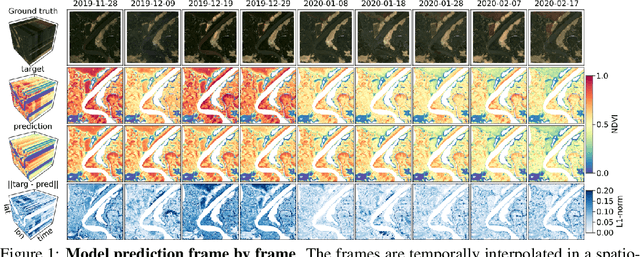

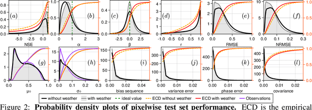
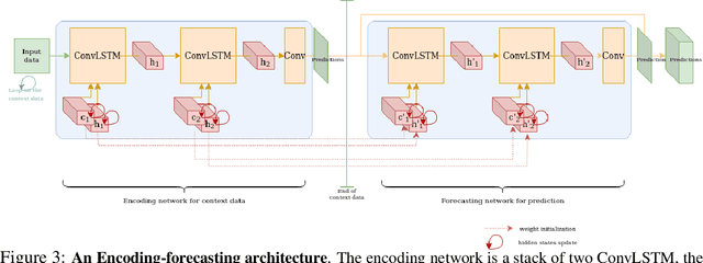
Abstract:Forecasting the state of vegetation in response to climate and weather events is a major challenge. Its implementation will prove crucial in predicting crop yield, forest damage, or more generally the impact on ecosystems services relevant for socio-economic functioning, which if absent can lead to humanitarian disasters. Vegetation status depends on weather and environmental conditions that modulate complex ecological processes taking place at several timescales. Interactions between vegetation and different environmental drivers express responses at instantaneous but also time-lagged effects, often showing an emerging spatial context at landscape and regional scales. We formulate the land surface forecasting task as a strongly guided video prediction task where the objective is to forecast the vegetation developing at very fine resolution using topography and weather variables to guide the prediction. We use a Convolutional LSTM (ConvLSTM) architecture to address this task and predict changes in the vegetation state in Africa using Sentinel-2 satellite NDVI, having ERA5 weather reanalysis, SMAP satellite measurements, and topography (DEM of SRTMv4.1) as variables to guide the prediction. Ours results highlight how ConvLSTM models can not only forecast the seasonal evolution of NDVI at high resolution, but also the differential impacts of weather anomalies over the baselines. The model is able to predict different vegetation types, even those with very high NDVI variability during target length, which is promising to support anticipatory actions in the context of drought-related disasters.
Deep Learning Methods for Daily Wildfire Danger Forecasting
Nov 04, 2021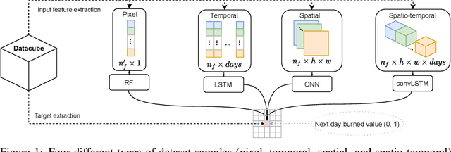

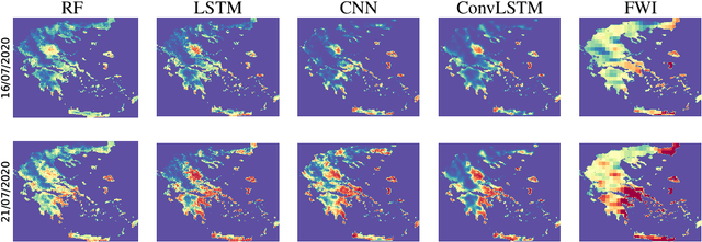
Abstract:Wildfire forecasting is of paramount importance for disaster risk reduction and environmental sustainability. We approach daily fire danger prediction as a machine learning task, using historical Earth observation data from the last decade to predict next-day's fire danger. To that end, we collect, pre-process and harmonize an open-access datacube, featuring a set of covariates that jointly affect the fire occurrence and spread, such as weather conditions, satellite-derived products, topography features and variables related to human activity. We implement a variety of Deep Learning (DL) models to capture the spatial, temporal or spatio-temporal context and compare them against a Random Forest (RF) baseline. We find that either spatial or temporal context is enough to surpass the RF, while a ConvLSTM that exploits the spatio-temporal context performs best with a test Area Under the Receiver Operating Characteristic of 0.926. Our DL-based proof-of-concept provides national-scale daily fire danger maps at a much higher spatial resolution than existing operational solutions.
 Add to Chrome
 Add to Firefox
 Add to Edge