Miguel-Ángel Fernández-Torres
Explainable Earth Surface Forecasting under Extreme Events
Oct 02, 2024


Abstract:With climate change-related extreme events on the rise, high dimensional Earth observation data presents a unique opportunity for forecasting and understanding impacts on ecosystems. This is, however, impeded by the complexity of processing, visualizing, modeling, and explaining this data. To showcase how this challenge can be met, here we train a convolutional long short-term memory-based architecture on the novel DeepExtremeCubes dataset. DeepExtremeCubes includes around 40,000 long-term Sentinel-2 minicubes (January 2016-October 2022) worldwide, along with labeled extreme events, meteorological data, vegetation land cover, and topography map, sampled from locations affected by extreme climate events and surrounding areas. When predicting future reflectances and vegetation impacts through kernel normalized difference vegetation index, the model achieved an R$^2$ score of 0.9055 in the test set. Explainable artificial intelligence was used to analyze the model's predictions during the October 2020 Central South America compound heatwave and drought event. We chose the same area exactly one year before the event as counterfactual, finding that the average temperature and surface pressure are generally the best predictors under normal conditions. In contrast, minimum anomalies of evaporation and surface latent heat flux take the lead during the event. A change of regime is also observed in the attributions before the event, which might help assess how long the event was brewing before happening. The code to replicate all experiments and figures in this paper is publicly available at https://github.com/DeepExtremes/txyXAI
AI for Extreme Event Modeling and Understanding: Methodologies and Challenges
Jun 28, 2024


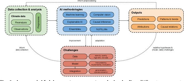
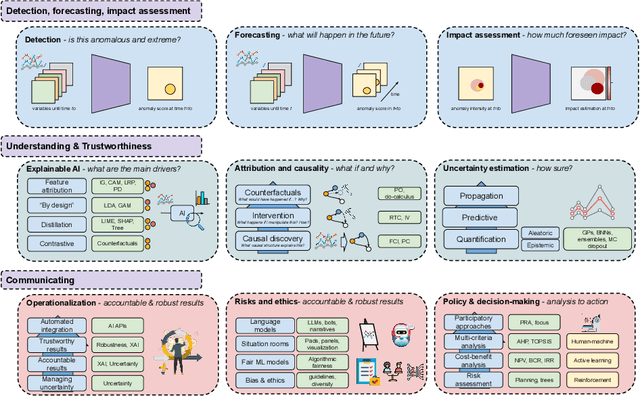
Abstract:In recent years, artificial intelligence (AI) has deeply impacted various fields, including Earth system sciences. Here, AI improved weather forecasting, model emulation, parameter estimation, and the prediction of extreme events. However, the latter comes with specific challenges, such as developing accurate predictors from noisy, heterogeneous and limited annotated data. This paper reviews how AI is being used to analyze extreme events (like floods, droughts, wildfires and heatwaves), highlighting the importance of creating accurate, transparent, and reliable AI models. We discuss the hurdles of dealing with limited data, integrating information in real-time, deploying models, and making them understandable, all crucial for gaining the trust of stakeholders and meeting regulatory needs. We provide an overview of how AI can help identify and explain extreme events more effectively, improving disaster response and communication. We emphasize the need for collaboration across different fields to create AI solutions that are practical, understandable, and trustworthy for analyzing and predicting extreme events. Such collaborative efforts aim to enhance disaster readiness and disaster risk reduction.
Hierarchical Representations for Spatio-Temporal Visual Attention Modeling and Understanding
Aug 09, 2023Abstract:This PhD. Thesis concerns the study and development of hierarchical representations for spatio-temporal visual attention modeling and understanding in video sequences. More specifically, we propose two computational models for visual attention. First, we present a generative probabilistic model for context-aware visual attention modeling and understanding. Secondly, we develop a deep network architecture for visual attention modeling, which first estimates top-down spatio-temporal visual attention, and ultimately serves for modeling attention in the temporal domain.
Deep Learning Methods for Daily Wildfire Danger Forecasting
Nov 04, 2021


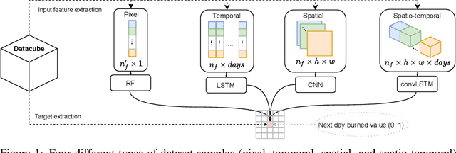
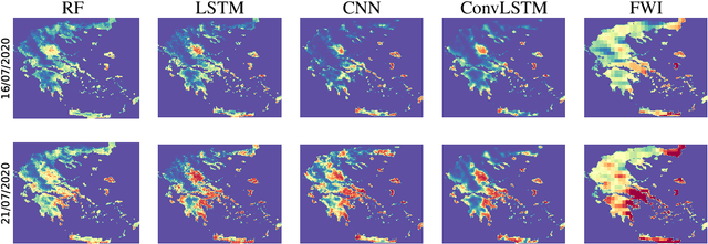
Abstract:Wildfire forecasting is of paramount importance for disaster risk reduction and environmental sustainability. We approach daily fire danger prediction as a machine learning task, using historical Earth observation data from the last decade to predict next-day's fire danger. To that end, we collect, pre-process and harmonize an open-access datacube, featuring a set of covariates that jointly affect the fire occurrence and spread, such as weather conditions, satellite-derived products, topography features and variables related to human activity. We implement a variety of Deep Learning (DL) models to capture the spatial, temporal or spatio-temporal context and compare them against a Random Forest (RF) baseline. We find that either spatial or temporal context is enough to surpass the RF, while a ConvLSTM that exploits the spatio-temporal context performs best with a test Area Under the Receiver Operating Characteristic of 0.926. Our DL-based proof-of-concept provides national-scale daily fire danger maps at a much higher spatial resolution than existing operational solutions.
 Add to Chrome
 Add to Firefox
 Add to Edge