Oscar J. Pellicer-Valero
Video Compression for Spatiotemporal Earth System Data
Jun 24, 2025Abstract:Large-scale Earth system datasets, from high-resolution remote sensing imagery to spatiotemporal climate model outputs, exhibit characteristics analogous to those of standard videos. Their inherent spatial, temporal, and spectral redundancies can thus be readily exploited by established video compression techniques. Here, we present xarrayvideo, a Python library for compressing multichannel spatiotemporal datasets by encoding them as videos. Our approach achieves compression ratios of up to 250x while maintaining high fidelity by leveraging standard, well-optimized video codecs through ffmpeg. We demonstrate the library's effectiveness on four real-world multichannel spatiotemporal datasets: DynamicEarthNet (very high resolution Planet images), DeepExtremeCubes (high resolution Sentinel-2 images), ERA5 (weather reanalysis data), and the SimpleS2 dataset (high resolution multichannel Sentinel-2 images), achieving Peak Signal-to-Noise Ratios (PSNRs) of 55.86, 40.60, 46.58, and 43.23 dB at 0.1 bits per pixel per band (bpppb) and 65.91, 54.28, 62.90, and 55.04 dB at 1 bpppb. We are redistributing two of these datasets, DeepExtremeCubes (2.3 Tb) and DynamicEarthNet (525 Gb), in the machine-learning-ready and cloud-ready TACO format through HuggingFace at significantly reduced sizes (270 Gb and 8.5 Gb, respectively) without compromising quality (PSNR 55.77-56.65 and 60.15). No performance loss is observed when the compressed versions of these datasets are used in their respective deep learning-based downstream tasks (next step reflectance prediction and landcover segmentation). In conclusion, xarrayvideo presents an efficient solution for handling the rapidly growing size of Earth observation datasets, making advanced compression techniques accessible and practical to the Earth science community. The library is available for use at https://github.com/IPL-UV/xarrayvideo
Explainable Earth Surface Forecasting under Extreme Events
Oct 02, 2024


Abstract:With climate change-related extreme events on the rise, high dimensional Earth observation data presents a unique opportunity for forecasting and understanding impacts on ecosystems. This is, however, impeded by the complexity of processing, visualizing, modeling, and explaining this data. To showcase how this challenge can be met, here we train a convolutional long short-term memory-based architecture on the novel DeepExtremeCubes dataset. DeepExtremeCubes includes around 40,000 long-term Sentinel-2 minicubes (January 2016-October 2022) worldwide, along with labeled extreme events, meteorological data, vegetation land cover, and topography map, sampled from locations affected by extreme climate events and surrounding areas. When predicting future reflectances and vegetation impacts through kernel normalized difference vegetation index, the model achieved an R$^2$ score of 0.9055 in the test set. Explainable artificial intelligence was used to analyze the model's predictions during the October 2020 Central South America compound heatwave and drought event. We chose the same area exactly one year before the event as counterfactual, finding that the average temperature and surface pressure are generally the best predictors under normal conditions. In contrast, minimum anomalies of evaporation and surface latent heat flux take the lead during the event. A change of regime is also observed in the attributions before the event, which might help assess how long the event was brewing before happening. The code to replicate all experiments and figures in this paper is publicly available at https://github.com/DeepExtremes/txyXAI
AI for Extreme Event Modeling and Understanding: Methodologies and Challenges
Jun 28, 2024


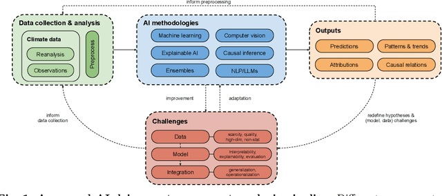
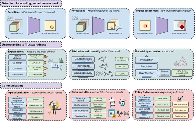
Abstract:In recent years, artificial intelligence (AI) has deeply impacted various fields, including Earth system sciences. Here, AI improved weather forecasting, model emulation, parameter estimation, and the prediction of extreme events. However, the latter comes with specific challenges, such as developing accurate predictors from noisy, heterogeneous and limited annotated data. This paper reviews how AI is being used to analyze extreme events (like floods, droughts, wildfires and heatwaves), highlighting the importance of creating accurate, transparent, and reliable AI models. We discuss the hurdles of dealing with limited data, integrating information in real-time, deploying models, and making them understandable, all crucial for gaining the trust of stakeholders and meeting regulatory needs. We provide an overview of how AI can help identify and explain extreme events more effectively, improving disaster response and communication. We emphasize the need for collaboration across different fields to create AI solutions that are practical, understandable, and trustworthy for analyzing and predicting extreme events. Such collaborative efforts aim to enhance disaster readiness and disaster risk reduction.
DeepExtremeCubes: Integrating Earth system spatio-temporal data for impact assessment of climate extremes
Jun 26, 2024


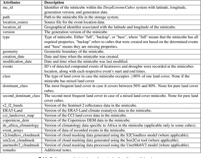
Abstract:With climate extremes' rising frequency and intensity, robust analytical tools are crucial to predict their impacts on terrestrial ecosystems. Machine learning techniques show promise but require well-structured, high-quality, and curated analysis-ready datasets. Earth observation datasets comprehensively monitor ecosystem dynamics and responses to climatic extremes, yet the data complexity can challenge the effectiveness of machine learning models. Despite recent progress in deep learning to ecosystem monitoring, there is a need for datasets specifically designed to analyse compound heatwave and drought extreme impact. Here, we introduce the DeepExtremeCubes database, tailored to map around these extremes, focusing on persistent natural vegetation. It comprises over 40,000 spatially sampled small data cubes (i.e. minicubes) globally, with a spatial coverage of 2.5 by 2.5 km. Each minicube includes (i) Sentinel-2 L2A images, (ii) ERA5-Land variables and generated extreme event cube covering 2016 to 2022, and (iii) ancillary land cover and topography maps. The paper aims to (1) streamline data accessibility, structuring, pre-processing, and enhance scientific reproducibility, and (2) facilitate biosphere dynamics forecasting in response to compound extremes.
Deep Learning for fully automatic detection, segmentation, and Gleason Grade estimation of prostate cancer in multiparametric Magnetic Resonance Images
Mar 24, 2021


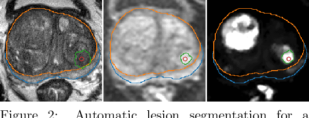
Abstract:The emergence of multi-parametric magnetic resonance imaging (mpMRI) has had a profound impact on the diagnosis of prostate cancers (PCa), which is the most prevalent malignancy in males in the western world, enabling a better selection of patients for confirmation biopsy. However, analyzing these images is complex even for experts, hence opening an opportunity for computer-aided diagnosis systems to seize. This paper proposes a fully automatic system based on Deep Learning that takes a prostate mpMRI from a PCa-suspect patient and, by leveraging the Retina U-Net detection framework, locates PCa lesions, segments them, and predicts their most likely Gleason grade group (GGG). It uses 490 mpMRIs for training/validation, and 75 patients for testing from two different datasets: ProstateX and IVO (Valencia Oncology Institute Foundation). In the test set, it achieves an excellent lesion-level AUC/sensitivity/specificity for the GGG$\geq$2 significance criterion of 0.96/1.00/0.79 for the ProstateX dataset, and 0.95/1.00/0.80 for the IVO dataset. Evaluated at a patient level, the results are 0.87/1.00/0.375 in ProstateX, and 0.91/1.00/0.762 in IVO. Furthermore, on the online ProstateX grand challenge, the model obtained an AUC of 0.85 (0.87 when trained only on the ProstateX data, tying up with the original winner of the challenge). For expert comparison, IVO radiologist's PI-RADS 4 sensitivity/specificity were 0.88/0.56 at a lesion level, and 0.85/0.58 at a patient level. Additional subsystems for automatic prostate zonal segmentation and mpMRI non-rigid sequence registration were also employed to produce the final fully automated system. The code for the ProstateX-trained system has been made openly available at https://github.com/OscarPellicer/prostate_lesion_detection. We hope that this will represent a landmark for future research to use, compare and improve upon.
 Add to Chrome
 Add to Firefox
 Add to Edge