Lazaro Alonso
SeasFire as a Multivariate Earth System Datacube for Wildfire Dynamics
Dec 22, 2023


Abstract:The global occurrence, scale, and frequency of wildfires pose significant threats to ecosystem services and human livelihoods. To effectively quantify and attribute the antecedent conditions for wildfires, a thorough understanding of Earth system dynamics is imperative. In response, we introduce the SeasFire datacube, a meticulously curated spatiotemporal dataset tailored for global sub-seasonal to seasonal wildfire modeling via Earth observation. The SeasFire datacube comprises of 59 variables encompassing climate, vegetation, oceanic indices, and human factors, has an 8-day temporal resolution and a spatial resolution of 0.25$^{\circ}$, and spans from 2001 to 2021. We showcase the versatility of SeasFire for exploring the variability and seasonality of wildfire drivers, modeling causal links between ocean-climate teleconnections and wildfires, and predicting sub-seasonal wildfire patterns across multiple timescales with a Deep Learning model. We publicly release the SeasFire datacube and appeal to Earth system scientists and Machine Learning practitioners to use it for an improved understanding and anticipation of wildfires.
Forecasting localized weather impacts on vegetation as seen from space with meteo-guided video prediction
Mar 28, 2023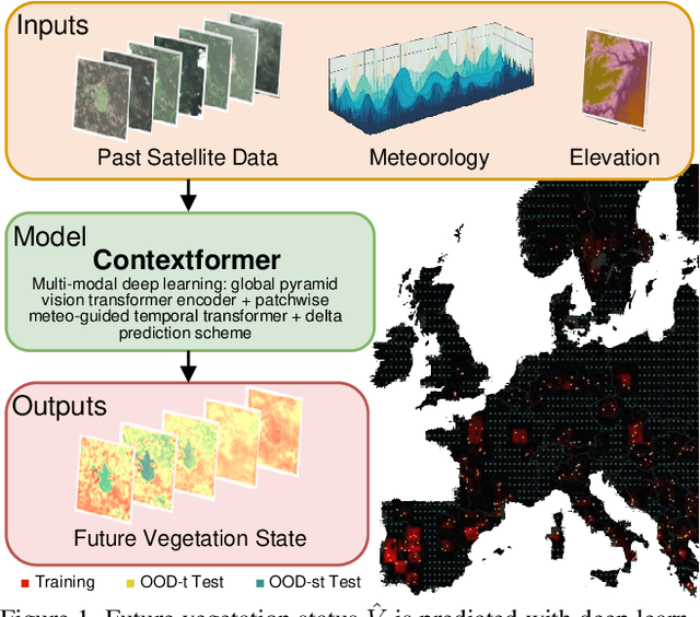
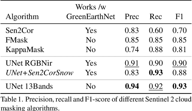

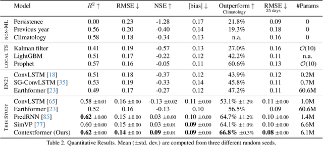
Abstract:We present a novel approach for modeling vegetation response to weather in Europe as measured by the Sentinel 2 satellite. Existing satellite imagery forecasting approaches focus on photorealistic quality of the multispectral images, while derived vegetation dynamics have not yet received as much attention. We leverage both spatial and temporal context by extending state-of-the-art video prediction methods with weather guidance. We extend the EarthNet2021 dataset to be suitable for vegetation modeling by introducing a learned cloud mask and an appropriate evaluation scheme. Qualitative and quantitative experiments demonstrate superior performance of our approach over a wide variety of baseline methods, including leading approaches to satellite imagery forecasting. Additionally, we show how our modeled vegetation dynamics can be leveraged in a downstream task: inferring gross primary productivity for carbon monitoring. To the best of our knowledge, this work presents the first models for continental-scale vegetation modeling at fine resolution able to capture anomalies beyond the seasonal cycle, thereby paving the way for predictive assessments of vegetation status.
Deep Learning for Global Wildfire Forecasting
Nov 06, 2022


Abstract:Climate change is expected to aggravate wildfire activity through the exacerbation of fire weather. Improving our capabilities to anticipate wildfires on a global scale is of uttermost importance for mitigating their negative effects. In this work, we create a global fire dataset and demonstrate a prototype for predicting the presence of global burned areas on a sub-seasonal scale with the use of segmentation deep learning models. Particularly, we present an open-access global analysis-ready datacube, which contains a variety of variables related to the seasonal and sub-seasonal fire drivers (climate, vegetation, oceanic indices, human-related variables), as well as the historical burned areas and wildfire emissions for 2001-2021. We train a deep learning model, which treats global wildfire forecasting as an image segmentation task and skillfully predicts the presence of burned areas 8, 16, 32 and 64 days ahead of time. Our work motivates the use of deep learning for global burned area forecasting and paves the way towards improved anticipation of global wildfire patterns.
Learning to forecast vegetation greenness at fine resolution over Africa with ConvLSTMs
Oct 24, 2022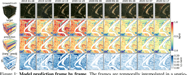

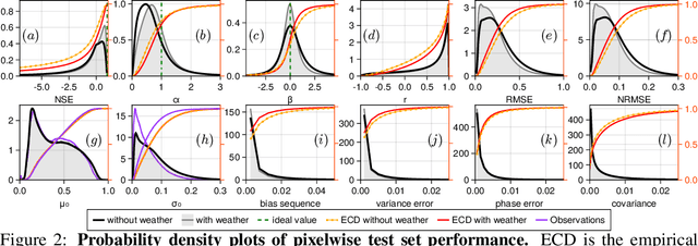
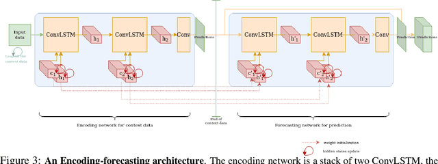
Abstract:Forecasting the state of vegetation in response to climate and weather events is a major challenge. Its implementation will prove crucial in predicting crop yield, forest damage, or more generally the impact on ecosystems services relevant for socio-economic functioning, which if absent can lead to humanitarian disasters. Vegetation status depends on weather and environmental conditions that modulate complex ecological processes taking place at several timescales. Interactions between vegetation and different environmental drivers express responses at instantaneous but also time-lagged effects, often showing an emerging spatial context at landscape and regional scales. We formulate the land surface forecasting task as a strongly guided video prediction task where the objective is to forecast the vegetation developing at very fine resolution using topography and weather variables to guide the prediction. We use a Convolutional LSTM (ConvLSTM) architecture to address this task and predict changes in the vegetation state in Africa using Sentinel-2 satellite NDVI, having ERA5 weather reanalysis, SMAP satellite measurements, and topography (DEM of SRTMv4.1) as variables to guide the prediction. Ours results highlight how ConvLSTM models can not only forecast the seasonal evolution of NDVI at high resolution, but also the differential impacts of weather anomalies over the baselines. The model is able to predict different vegetation types, even those with very high NDVI variability during target length, which is promising to support anticipatory actions in the context of drought-related disasters.
 Add to Chrome
 Add to Firefox
 Add to Edge