Yutong Xia
FlowNet: Modeling Dynamic Spatio-Temporal Systems via Flow Propagation
Nov 05, 2025Abstract:Accurately modeling complex dynamic spatio-temporal systems requires capturing flow-mediated interdependencies and context-sensitive interaction dynamics. Existing methods, predominantly graph-based or attention-driven, rely on similarity-driven connectivity assumptions, neglecting asymmetric flow exchanges that govern system evolution. We propose Spatio-Temporal Flow, a physics-inspired paradigm that explicitly models dynamic node couplings through quantifiable flow transfers governed by conservation principles. Building on this, we design FlowNet, a novel architecture leveraging flow tokens as information carriers to simulate source-to-destination transfers via Flow Allocation Modules, ensuring state redistribution aligns with conservation laws. FlowNet dynamically adjusts the interaction radius through an Adaptive Spatial Masking module, suppressing irrelevant noise while enabling context-aware propagation. A cascaded architecture enhances scalability and nonlinear representation capacity. Experiments demonstrate that FlowNet significantly outperforms existing state-of-the-art approaches on seven metrics in the modeling of three real-world systems, validating its efficiency and physical interpretability. We establish a principled methodology for modeling complex systems through spatio-temporal flow interactions.
CaPulse: Detecting Anomalies by Tuning in to the Causal Rhythms of Time Series
Aug 06, 2025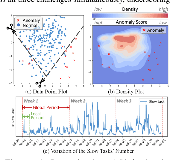
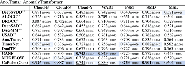
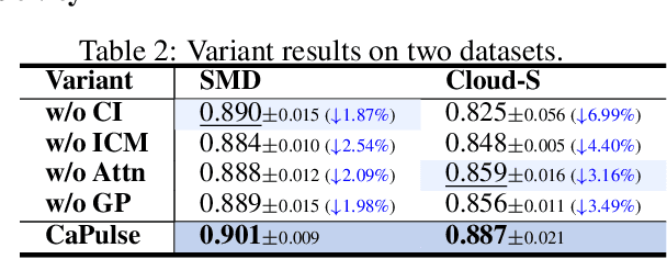
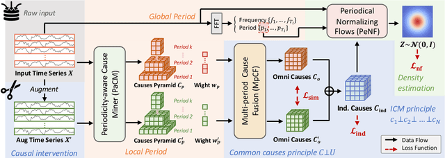
Abstract:Time series anomaly detection has garnered considerable attention across diverse domains. While existing methods often fail to capture the underlying mechanisms behind anomaly generation in time series data. In addition, time series anomaly detection often faces several data-related inherent challenges, i.e., label scarcity, data imbalance, and complex multi-periodicity. In this paper, we leverage causal tools and introduce a new causality-based framework, CaPulse, which tunes in to the underlying causal pulse of time series data to effectively detect anomalies. Concretely, we begin by building a structural causal model to decipher the generation processes behind anomalies. To tackle the challenges posed by the data, we propose Periodical Normalizing Flows with a novel mask mechanism and carefully designed periodical learners, creating a periodicity-aware, density-based anomaly detection approach. Extensive experiments on seven real-world datasets demonstrate that CaPulse consistently outperforms existing methods, achieving AUROC improvements of 3% to 17%, with enhanced interpretability.
Reimagining Urban Science: Scaling Causal Inference with Large Language Models
Apr 15, 2025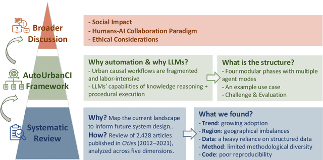
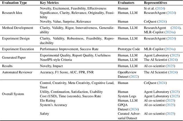
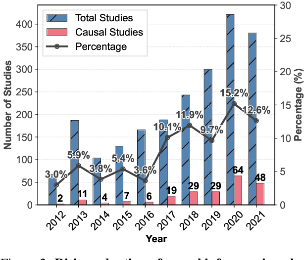
Abstract:Urban causal research is essential for understanding the complex dynamics of cities and informing evidence-based policies. However, it is challenged by the inefficiency and bias of hypothesis generation, barriers to multimodal data complexity, and the methodological fragility of causal experimentation. Recent advances in large language models (LLMs) present an opportunity to rethink how urban causal analysis is conducted. This Perspective examines current urban causal research by analyzing taxonomies that categorize research topics, data sources, and methodological approaches to identify structural gaps. We then introduce an LLM-driven conceptual framework, AutoUrbanCI, composed of four distinct modular agents responsible for hypothesis generation, data engineering, experiment design and execution, and results interpretation with policy recommendations. We propose evaluation criteria for rigor and transparency and reflect on implications for human-AI collaboration, equity, and accountability. We call for a new research agenda that embraces AI-augmented workflows not as replacements for human expertise but as tools to broaden participation, improve reproducibility, and unlock more inclusive forms of urban causal reasoning.
Certainly Bot Or Not? Trustworthy Social Bot Detection via Robust Multi-Modal Neural Processes
Mar 11, 2025


Abstract:Social bot detection is crucial for mitigating misinformation, online manipulation, and coordinated inauthentic behavior. While existing neural network-based detectors perform well on benchmarks, they struggle with generalization due to distribution shifts across datasets and frequently produce overconfident predictions for out-of-distribution accounts beyond the training data. To address this, we introduce a novel Uncertainty Estimation for Social Bot Detection (UESBD) framework, which quantifies the predictive uncertainty of detectors beyond mere classification. For this task, we propose Robust Multi-modal Neural Processes (RMNP), which aims to enhance the robustness of multi-modal neural processes to modality inconsistencies caused by social bot camouflage. RMNP first learns unimodal representations through modality-specific encoders. Then, unimodal attentive neural processes are employed to encode the Gaussian distribution of unimodal latent variables. Furthermore, to avoid social bots stealing human features to camouflage themselves thus causing certain modalities to provide conflictive information, we introduce an evidential gating network to explicitly model the reliability of modalities. The joint latent distribution is learned through the generalized product of experts, which takes the reliability of each modality into consideration during fusion. The final prediction is obtained through Monte Carlo sampling of the joint latent distribution followed by a decoder. Experiments on three real-world benchmarks show the effectiveness of RMNP in classification and uncertainty estimation, as well as its robustness to modality conflicts.
Evolutionary Greedy Algorithm for Optimal Sensor Placement Problem in Urban Sewage Surveillance
Sep 25, 2024


Abstract:Designing a cost-effective sensor placement plan for sewage surveillance is a crucial task because it allows cost-effective early pandemic outbreak detection as supplementation for individual testing. However, this problem is computationally challenging to solve, especially for massive sewage networks having complicated topologies. In this paper, we formulate this problem as a multi-objective optimization problem to consider the conflicting objectives and put forward a novel evolutionary greedy algorithm (EG) to enable efficient and effective optimization for large-scale directed networks. The proposed model is evaluated on both small-scale synthetic networks and a large-scale, real-world sewage network in Hong Kong. The experiments on small-scale synthetic networks demonstrate a consistent efficiency improvement with reasonable optimization performance and the real-world application shows that our method is effective in generating optimal sensor placement plans to guide policy-making.
Predicting Parking Availability in Singapore with Cross-Domain Data: A New Dataset and A Data-Driven Approach
May 29, 2024


Abstract:The increasing number of vehicles highlights the need for efficient parking space management. Predicting real-time Parking Availability (PA) can help mitigate traffic congestion and the corresponding social problems, which is a pressing issue in densely populated cities like Singapore. In this study, we aim to collectively predict future PA across Singapore with complex factors from various domains. The contributions in this paper are listed as follows: (1) A New Dataset: We introduce the \texttt{SINPA} dataset, containing a year's worth of PA data from 1,687 parking lots in Singapore, enriched with various spatial and temporal factors. (2) A Data-Driven Approach: We present DeepPA, a novel deep-learning framework, to collectively and efficiently predict future PA across thousands of parking lots. (3) Extensive Experiments and Deployment: DeepPA demonstrates a 9.2% reduction in prediction error for up to 3-hour forecasts compared to existing advanced models. Furthermore, we implement DeepPA in a practical web-based platform to provide real-time PA predictions to aid drivers and inform urban planning for the governors in Singapore. We release the dataset and source code at https://github.com/yoshall/SINPA.
DynST: Dynamic Sparse Training for Resource-Constrained Spatio-Temporal Forecasting
Mar 05, 2024


Abstract:The ever-increasing sensor service, though opening a precious path and providing a deluge of earth system data for deep-learning-oriented earth science, sadly introduce a daunting obstacle to their industrial level deployment. Concretely, earth science systems rely heavily on the extensive deployment of sensors, however, the data collection from sensors is constrained by complex geographical and social factors, making it challenging to achieve comprehensive coverage and uniform deployment. To alleviate the obstacle, traditional approaches to sensor deployment utilize specific algorithms to design and deploy sensors. These methods dynamically adjust the activation times of sensors to optimize the detection process across each sub-region. Regrettably, formulating an activation strategy generally based on historical observations and geographic characteristics, which make the methods and resultant models were neither simple nor practical. Worse still, the complex technical design may ultimately lead to a model with weak generalizability. In this paper, we introduce for the first time the concept of spatio-temporal data dynamic sparse training and are committed to adaptively, dynamically filtering important sensor distributions. To our knowledge, this is the first proposal (termed DynST) of an industry-level deployment optimization concept at the data level. However, due to the existence of the temporal dimension, pruning of spatio-temporal data may lead to conflicts at different timestamps. To achieve this goal, we employ dynamic merge technology, along with ingenious dimensional mapping to mitigate potential impacts caused by the temporal aspect. During the training process, DynST utilize iterative pruning and sparse training, repeatedly identifying and dynamically removing sensor perception areas that contribute the least to future predictions.
Spatio-Temporal Field Neural Networks for Air Quality Inference
Mar 02, 2024


Abstract:The air quality inference problem aims to utilize historical data from a limited number of observation sites to infer the air quality index at an unknown location. Considering the sparsity of data due to the high maintenance cost of the stations, good inference algorithms can effectively save the cost and refine the data granularity. While spatio-temporal graph neural networks have made excellent progress on this problem, their non-Euclidean and discrete data structure modeling of reality limits its potential. In this work, we make the first attempt to combine two different spatio-temporal perspectives, fields and graphs, by proposing a new model, Spatio-Temporal Field Neural Network, and its corresponding new framework, Pyramidal Inference. Extensive experiments validate that our model achieves state-of-the-art performance in nationwide air quality inference in the Chinese Mainland, demonstrating the superiority of our proposed model and framework.
Through the Dual-Prism: A Spectral Perspective on Graph Data Augmentation for Graph Classification
Jan 22, 2024


Abstract:Graph Neural Networks (GNNs) have become the preferred tool to process graph data, with their efficacy being boosted through graph data augmentation techniques. Despite the evolution of augmentation methods, issues like graph property distortions and restricted structural changes persist. This leads to the question: Is it possible to develop more property-conserving and structure-sensitive augmentation methods? Through a spectral lens, we investigate the interplay between graph properties, their augmentation, and their spectral behavior, and found that keeping the low-frequency eigenvalues unchanged can preserve the critical properties at a large scale when generating augmented graphs. These observations inform our introduction of the Dual-Prism (DP) augmentation method, comprising DP-Noise and DP-Mask, which adeptly retains essential graph properties while diversifying augmented graphs. Extensive experiments validate the efficiency of our approach, providing a new and promising direction for graph data augmentation.
Deciphering Spatio-Temporal Graph Forecasting: A Causal Lens and Treatment
Sep 23, 2023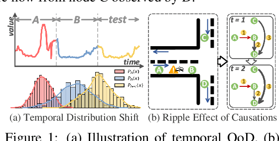
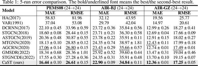

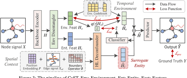
Abstract:Spatio-Temporal Graph (STG) forecasting is a fundamental task in many real-world applications. Spatio-Temporal Graph Neural Networks have emerged as the most popular method for STG forecasting, but they often struggle with temporal out-of-distribution (OoD) issues and dynamic spatial causation. In this paper, we propose a novel framework called CaST to tackle these two challenges via causal treatments. Concretely, leveraging a causal lens, we first build a structural causal model to decipher the data generation process of STGs. To handle the temporal OoD issue, we employ the back-door adjustment by a novel disentanglement block to separate invariant parts and temporal environments from input data. Moreover, we utilize the front-door adjustment and adopt the Hodge-Laplacian operator for edge-level convolution to model the ripple effect of causation. Experiments results on three real-world datasets demonstrate the effectiveness and practicality of CaST, which consistently outperforms existing methods with good interpretability.
 Add to Chrome
 Add to Firefox
 Add to Edge