Yifan Duan
STDArm: Transferring Visuomotor Policies From Static Data Training to Dynamic Robot Manipulation
Apr 26, 2025Abstract:Recent advances in mobile robotic platforms like quadruped robots and drones have spurred a demand for deploying visuomotor policies in increasingly dynamic environments. However, the collection of high-quality training data, the impact of platform motion and processing delays, and limited onboard computing resources pose significant barriers to existing solutions. In this work, we present STDArm, a system that directly transfers policies trained under static conditions to dynamic platforms without extensive modifications. The core of STDArm is a real-time action correction framework consisting of: (1) an action manager to boost control frequency and maintain temporal consistency, (2) a stabilizer with a lightweight prediction network to compensate for motion disturbances, and (3) an online latency estimation module for calibrating system parameters. In this way, STDArm achieves centimeter-level precision in mobile manipulation tasks. We conduct comprehensive evaluations of the proposed STDArm on two types of robotic arms, four types of mobile platforms, and three tasks. Experimental results indicate that the STDArm enables real-time compensation for platform motion disturbances while preserving the original policy's manipulation capabilities, achieving centimeter-level operational precision during robot motion.
MT-PCR: Leveraging Modality Transformation for Large-Scale Point Cloud Registration with Limited Overlap
Mar 17, 2025


Abstract:Large-scale scene point cloud registration with limited overlap is a challenging task due to computational load and constrained data acquisition. To tackle these issues, we propose a point cloud registration method, MT-PCR, based on Modality Transformation. MT-PCR leverages a BEV capturing the maximal overlap information to improve the accuracy and utilizes images to provide complementary spatial features. Specifically, MT-PCR converts 3D point clouds to BEV images and eastimates correspondence by 2D image keypoints extraction and matching. Subsequently, the 2D correspondence estimates are then transformed back to 3D point clouds using inverse mapping. We have applied MT-PCR to Terrestrial Laser Scanning and Aerial Laser Scanning point cloud registration on the GrAco dataset, involving 8 low-overlap, square-kilometer scale registration scenarios. Experiments and comparisons with commonly used methods demonstrate that MT-PCR can achieve superior accuracy and robustness in large-scale scenes with limited overlap.
AgentSafe: Safeguarding Large Language Model-based Multi-agent Systems via Hierarchical Data Management
Mar 06, 2025Abstract:Large Language Model based multi-agent systems are revolutionizing autonomous communication and collaboration, yet they remain vulnerable to security threats like unauthorized access and data breaches. To address this, we introduce AgentSafe, a novel framework that enhances MAS security through hierarchical information management and memory protection. AgentSafe classifies information by security levels, restricting sensitive data access to authorized agents. AgentSafe incorporates two components: ThreatSieve, which secures communication by verifying information authority and preventing impersonation, and HierarCache, an adaptive memory management system that defends against unauthorized access and malicious poisoning, representing the first systematic defense for agent memory. Experiments across various LLMs show that AgentSafe significantly boosts system resilience, achieving defense success rates above 80% under adversarial conditions. Additionally, AgentSafe demonstrates scalability, maintaining robust performance as agent numbers and information complexity grow. Results underscore effectiveness of AgentSafe in securing MAS and its potential for real-world application.
The Power of Personality: A Human Simulation Perspective to Investigate Large Language Model Agents
Feb 28, 2025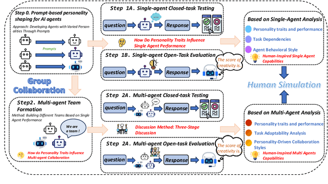
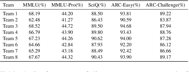


Abstract:Large language models (LLMs) excel in both closed tasks (including problem-solving, and code generation) and open tasks (including creative writing), yet existing explanations for their capabilities lack connections to real-world human intelligence. To fill this gap, this paper systematically investigates LLM intelligence through the lens of ``human simulation'', addressing three core questions: (1) How do personality traits affect problem-solving in closed tasks? (2) How do traits shape creativity in open tasks? (3) How does single-agent performance influence multi-agent collaboration? By assigning Big Five personality traits to LLM agents and evaluating their performance in single- and multi-agent settings, we reveal that specific traits significantly influence reasoning accuracy (closed tasks) and creative output (open tasks). Furthermore, multi-agent systems exhibit collective intelligence distinct from individual capabilities, driven by distinguishing combinations of personalities. We demonstrate that LLMs inherently simulate human behavior through next-token prediction, mirroring human language, decision-making, and collaborative dynamics.
OG-Gaussian: Occupancy Based Street Gaussians for Autonomous Driving
Feb 20, 2025Abstract:Accurate and realistic 3D scene reconstruction enables the lifelike creation of autonomous driving simulation environments. With advancements in 3D Gaussian Splatting (3DGS), previous studies have applied it to reconstruct complex dynamic driving scenes. These methods typically require expensive LiDAR sensors and pre-annotated datasets of dynamic objects. To address these challenges, we propose OG-Gaussian, a novel approach that replaces LiDAR point clouds with Occupancy Grids (OGs) generated from surround-view camera images using Occupancy Prediction Network (ONet). Our method leverages the semantic information in OGs to separate dynamic vehicles from static street background, converting these grids into two distinct sets of initial point clouds for reconstructing both static and dynamic objects. Additionally, we estimate the trajectories and poses of dynamic objects through a learning-based approach, eliminating the need for complex manual annotations. Experiments on Waymo Open dataset demonstrate that OG-Gaussian is on par with the current state-of-the-art in terms of reconstruction quality and rendering speed, achieving an average PSNR of 35.13 and a rendering speed of 143 FPS, while significantly reducing computational costs and economic overhead.
RaCFormer: Towards High-Quality 3D Object Detection via Query-based Radar-Camera Fusion
Dec 17, 2024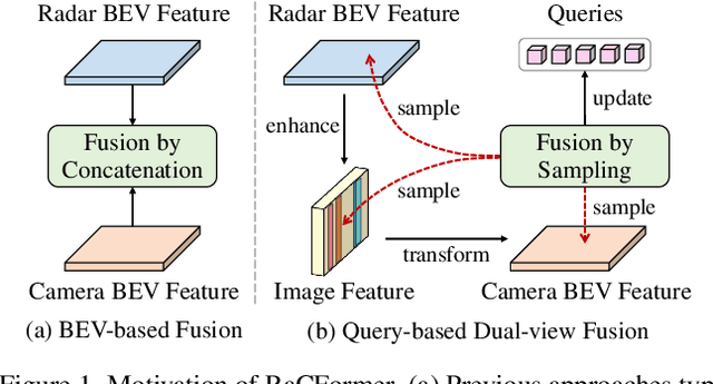
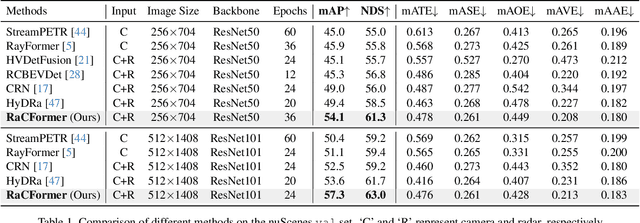
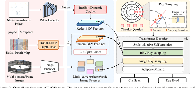
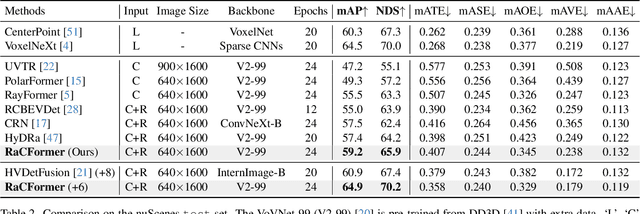
Abstract:We propose Radar-Camera fusion transformer (RaCFormer) to boost the accuracy of 3D object detection by the following insight. The Radar-Camera fusion in outdoor 3D scene perception is capped by the image-to-BEV transformation--if the depth of pixels is not accurately estimated, the naive combination of BEV features actually integrates unaligned visual content. To avoid this problem, we propose a query-based framework that enables adaptively sample instance-relevant features from both the BEV and the original image view. Furthermore, we enhance system performance by two key designs: optimizing query initialization and strengthening the representational capacity of BEV. For the former, we introduce an adaptive circular distribution in polar coordinates to refine the initialization of object queries, allowing for a distance-based adjustment of query density. For the latter, we initially incorporate a radar-guided depth head to refine the transformation from image view to BEV. Subsequently, we focus on leveraging the Doppler effect of radar and introduce an implicit dynamic catcher to capture the temporal elements within the BEV. Extensive experiments on nuScenes and View-of-Delft (VoD) datasets validate the merits of our design. Remarkably, our method achieves superior results of 64.9% mAP and 70.2% NDS on nuScenes, even outperforming several LiDAR-based detectors. RaCFormer also secures the 1st ranking on the VoD dataset. The code will be released.
Map++: Towards User-Participatory Visual SLAM Systems with Efficient Map Expansion and Sharing
Nov 04, 2024


Abstract:Constructing precise 3D maps is crucial for the development of future map-based systems such as self-driving and navigation. However, generating these maps in complex environments, such as multi-level parking garages or shopping malls, remains a formidable challenge. In this paper, we introduce a participatory sensing approach that delegates map-building tasks to map users, thereby enabling cost-effective and continuous data collection. The proposed method harnesses the collective efforts of users, facilitating the expansion and ongoing update of the maps as the environment evolves. We realized this approach by developing Map++, an efficient system that functions as a plug-and-play extension, supporting participatory map-building based on existing SLAM algorithms. Map++ addresses a plethora of scalability issues in this participatory map-building system by proposing a set of lightweight, application-layer protocols. We evaluated Map++ in four representative settings: an indoor garage, an outdoor plaza, a public SLAM benchmark, and a simulated environment. The results demonstrate that Map++ can reduce traffic volume by approximately 46% with negligible degradation in mapping accuracy, i.e., less than 0.03m compared to the baseline system. It can support approximately $2 \times$ as many concurrent users as the baseline under the same network bandwidth. Additionally, for users who travel on already-mapped trajectories, they can directly utilize the existing maps for localization and save 47% of the CPU usage.
CELLmap: Enhancing LiDAR SLAM through Elastic and Lightweight Spherical Map Representation
Sep 29, 2024


Abstract:SLAM is a fundamental capability of unmanned systems, with LiDAR-based SLAM gaining widespread adoption due to its high precision. Current SLAM systems can achieve centimeter-level accuracy within a short period. However, there are still several challenges when dealing with largescale mapping tasks including significant storage requirements and difficulty of reusing the constructed maps. To address this, we first design an elastic and lightweight map representation called CELLmap, composed of several CELLs, each representing the local map at the corresponding location. Then, we design a general backend including CELL-based bidirectional registration module and loop closure detection module to improve global map consistency. Our experiments have demonstrated that CELLmap can represent the precise geometric structure of large-scale maps of KITTI dataset using only about 60 MB. Additionally, our general backend achieves up to a 26.88% improvement over various LiDAR odometry methods.
Causal Deciphering and Inpainting in Spatio-Temporal Dynamics via Diffusion Model
Sep 29, 2024Abstract:Spatio-temporal (ST) prediction has garnered a De facto attention in earth sciences, such as meteorological prediction, human mobility perception. However, the scarcity of data coupled with the high expenses involved in sensor deployment results in notable data imbalances. Furthermore, models that are excessively customized and devoid of causal connections further undermine the generalizability and interpretability. To this end, we establish a causal framework for ST predictions, termed CaPaint, which targets to identify causal regions in data and endow model with causal reasoning ability in a two-stage process. Going beyond this process, we utilize the back-door adjustment to specifically address the sub-regions identified as non-causal in the upstream phase. Specifically, we employ a novel image inpainting technique. By using a fine-tuned unconditional Diffusion Probabilistic Model (DDPM) as the generative prior, we in-fill the masks defined as environmental parts, offering the possibility of reliable extrapolation for potential data distributions. CaPaint overcomes the high complexity dilemma of optimal ST causal discovery models by reducing the data generation complexity from exponential to quasi-linear levels. Extensive experiments conducted on five real-world ST benchmarks demonstrate that integrating the CaPaint concept allows models to achieve improvements ranging from 4.3% to 77.3%. Moreover, compared to traditional mainstream ST augmenters, CaPaint underscores the potential of diffusion models in ST enhancement, offering a novel paradigm for this field. Our project is available at https://anonymous.4open.science/r/12345-DFCC.
LFP: Efficient and Accurate End-to-End Lane-Level Planning via Camera-LiDAR Fusion
Sep 21, 2024


Abstract:Multi-modal systems enhance performance in autonomous driving but face inefficiencies due to indiscriminate processing within each modality. Additionally, the independent feature learning of each modality lacks interaction, which results in extracted features that do not possess the complementary characteristics. These issue increases the cost of fusing redundant information across modalities. To address these challenges, we propose targeting driving-relevant elements, which reduces the volume of LiDAR features while preserving critical information. This approach enhances lane level interaction between the image and LiDAR branches, allowing for the extraction and fusion of their respective advantageous features. Building upon the camera-only framework PHP, we introduce the Lane-level camera-LiDAR Fusion Planning (LFP) method, which balances efficiency with performance by using lanes as the unit for sensor fusion. Specifically, we design three modules to enhance efficiency and performance. For efficiency, we propose an image-guided coarse lane prior generation module that forecasts the region of interest (ROI) for lanes and assigns a confidence score, guiding LiDAR processing. The LiDAR feature extraction modules leverages lane-aware priors from the image branch to guide sampling for pillar, retaining essential pillars. For performance, the lane-level cross-modal query integration and feature enhancement module uses confidence score from ROI to combine low-confidence image queries with LiDAR queries, extracting complementary depth features. These features enhance the low-confidence image features, compensating for the lack of depth. Experiments on the Carla benchmarks show that our method achieves state-of-the-art performance in both driving score and infraction score, with maximum improvement of 15% and 14% over existing algorithms, respectively, maintaining high frame rate of 19.27 FPS.
 Add to Chrome
 Add to Firefox
 Add to Edge