Konrad Schindler
ETH Zürich, Switzerland
SPARC: Separating Perception And Reasoning Circuits for Test-time Scaling of VLMs
Feb 06, 2026Abstract:Despite recent successes, test-time scaling - i.e., dynamically expanding the token budget during inference as needed - remains brittle for vision-language models (VLMs): unstructured chains-of-thought about images entangle perception and reasoning, leading to long, disorganized contexts where small perceptual mistakes may cascade into completely wrong answers. Moreover, expensive reinforcement learning with hand-crafted rewards is required to achieve good performance. Here, we introduce SPARC (Separating Perception And Reasoning Circuits), a modular framework that explicitly decouples visual perception from reasoning. Inspired by sequential sensory-to-cognitive processing in the brain, SPARC implements a two-stage pipeline where the model first performs explicit visual search to localize question-relevant regions, then conditions its reasoning on those regions to produce the final answer. This separation enables independent test-time scaling with asymmetric compute allocation (e.g., prioritizing perceptual processing under distribution shift), supports selective optimization (e.g., improving the perceptual stage alone when it is the bottleneck for end-to-end performance), and accommodates compressed contexts by running global search at lower image resolutions and allocating high-resolution processing only to selected regions, thereby reducing total visual tokens count and compute. Across challenging visual reasoning benchmarks, SPARC outperforms monolithic baselines and strong visual-grounding approaches. For instance, SPARC improves the accuracy of Qwen3VL-4B on the $V^*$ VQA benchmark by 6.7 percentage points, and it surpasses "thinking with images" by 4.6 points on a challenging OOD task despite requiring a 200$\times$ lower token budget.
MambaVF: State Space Model for Efficient Video Fusion
Feb 05, 2026Abstract:Video fusion is a fundamental technique in various video processing tasks. However, existing video fusion methods heavily rely on optical flow estimation and feature warping, resulting in severe computational overhead and limited scalability. This paper presents MambaVF, an efficient video fusion framework based on state space models (SSMs) that performs temporal modeling without explicit motion estimation. First, by reformulating video fusion as a sequential state update process, MambaVF captures long-range temporal dependencies with linear complexity while significantly reducing computation and memory costs. Second, MambaVF proposes a lightweight SSM-based fusion module that replaces conventional flow-guided alignment via a spatio-temporal bidirectional scanning mechanism. This module enables efficient information aggregation across frames. Extensive experiments across multiple benchmarks demonstrate that our MambaVF achieves state-of-the-art performance in multi-exposure, multi-focus, infrared-visible, and medical video fusion tasks. We highlight that MambaVF enjoys high efficiency, reducing up to 92.25% of parameters and 88.79% of computational FLOPs and a 2.1x speedup compared to existing methods. Project page: https://mambavf.github.io
FastVMT: Eliminating Redundancy in Video Motion Transfer
Feb 05, 2026Abstract:Video motion transfer aims to synthesize videos by generating visual content according to a text prompt while transferring the motion pattern observed in a reference video. Recent methods predominantly use the Diffusion Transformer (DiT) architecture. To achieve satisfactory runtime, several methods attempt to accelerate the computations in the DiT, but fail to address structural sources of inefficiency. In this work, we identify and remove two types of computational redundancy in earlier work: motion redundancy arises because the generic DiT architecture does not reflect the fact that frame-to-frame motion is small and smooth; gradient redundancy occurs if one ignores that gradients change slowly along the diffusion trajectory. To mitigate motion redundancy, we mask the corresponding attention layers to a local neighborhood such that interaction weights are not computed unnecessarily distant image regions. To exploit gradient redundancy, we design an optimization scheme that reuses gradients from previous diffusion steps and skips unwarranted gradient computations. On average, FastVMT achieves a 3.43x speedup without degrading the visual fidelity or the temporal consistency of the generated videos.
Repurposing Protein Language Models for Latent Flow-Based Fitness Optimization
Feb 02, 2026Abstract:Protein fitness optimization is challenged by a vast combinatorial landscape where high-fitness variants are extremely sparse. Many current methods either underperform or require computationally expensive gradient-based sampling. We present CHASE, a framework that repurposes the evolutionary knowledge of pretrained protein language models by compressing their embeddings into a compact latent space. By training a conditional flow-matching model with classifier-free guidance, we enable the direct generation of high-fitness variants without predictor-based guidance during the ODE sampling steps. CHASE achieves state-of-the-art performance on AAV and GFP protein design benchmarks. Finally, we show that bootstrapping with synthetic data can further enhance performance in data-constrained settings.
Deep learning enables urban change profiling through alignment of historical maps
Feb 02, 2026Abstract:Prior to modern Earth observation technologies, historical maps provide a unique record of long-term urban transformation and offer a lens on the evolving identity of cities. However, extracting consistent and fine-grained change information from historical map series remains challenging due to spatial misalignment, cartographic variation, and degrading document quality, limiting most analyses to small-scale or qualitative approaches. We propose a fully automated, deep learning-based framework for fine-grained urban change analysis from large collections of historical maps, built on a modular design that integrates dense map alignment, multi-temporal object detection, and change profiling. This framework shifts the analysis of historical maps from ad hoc visual comparison toward systematic, quantitative characterization of urban change. Experiments demonstrate the robust performance of the proposed alignment and object detection methods. Applied to Paris between 1868 and 1937, the framework reveals the spatial and temporal heterogeneity in urban transformation, highlighting its relevance for research in the social sciences and humanities. The modular design of our framework further supports adaptation to diverse cartographic contexts and downstream applications.
Making Foundation Models Probabilistic via Singular Value Ensembles
Jan 29, 2026Abstract:Foundation models have become a dominant paradigm in machine learning, achieving remarkable performance across diverse tasks through large-scale pretraining. However, these models often yield overconfident, uncalibrated predictions. The standard approach to quantifying epistemic uncertainty, training an ensemble of independent models, incurs prohibitive computational costs that scale linearly with ensemble size, making it impractical for large foundation models. We propose Singular Value Ensemble (SVE), a parameter-efficient implicit ensemble method that builds on a simple, but powerful core assumption: namely, that the singular vectors of the weight matrices constitute meaningful subspaces of the model's knowledge. Pretrained foundation models encode rich, transferable information in their weight matrices. If the singular vectors are indeed meaningful (orthogonal) "knowledge directions". To obtain a model ensemble, we modulate only how strongly each direction contributes to the output. Rather than learning entirely new parameters, we freeze the singular vectors and only train per-member singular values that rescale the contribution of each direction in that shared knowledge basis. Ensemble diversity emerges naturally as stochastic initialization and random sampling of mini-batches during joint training cause different members to converge to different combinations of the same underlying knowledge. SVE achieves uncertainty quantification comparable to explicit deep ensembles while increasing the parameter count of the base model by less than 1%, making principled uncertainty estimation accessible in resource-constrained settings. We validate SVE on NLP and vision tasks with various different backbones and show that it improves calibration while maintaining predictive accuracy.
Elastic3D: Controllable Stereo Video Conversion with Guided Latent Decoding
Dec 16, 2025Abstract:The growing demand for immersive 3D content calls for automated monocular-to-stereo video conversion. We present Elastic3D, a controllable, direct end-to-end method for upgrading a conventional video to a binocular one. Our approach, based on (conditional) latent diffusion, avoids artifacts due to explicit depth estimation and warping. The key to its high-quality stereo video output is a novel, guided VAE decoder that ensures sharp and epipolar-consistent stereo video output. Moreover, our method gives the user control over the strength of the stereo effect (more precisely, the disparity range) at inference time, via an intuitive, scalar tuning knob. Experiments on three different datasets of real-world stereo videos show that our method outperforms both traditional warping-based and recent warping-free baselines and sets a new standard for reliable, controllable stereo video conversion. Please check the project page for the video samples https://elastic3d.github.io.
LitePT: Lighter Yet Stronger Point Transformer
Dec 15, 2025
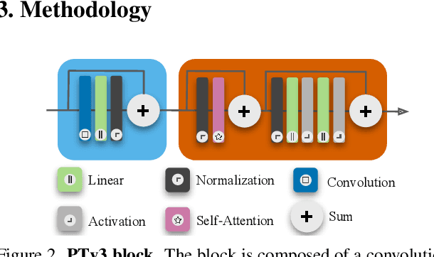
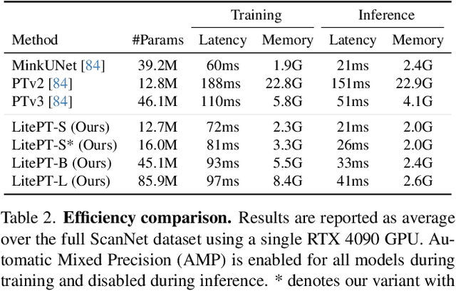
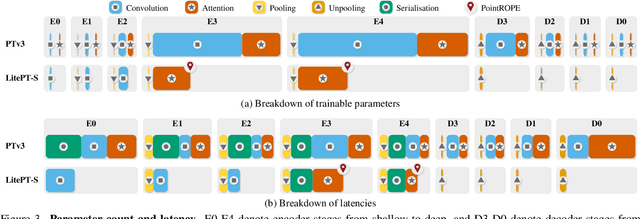
Abstract:Modern neural architectures for 3D point cloud processing contain both convolutional layers and attention blocks, but the best way to assemble them remains unclear. We analyse the role of different computational blocks in 3D point cloud networks and find an intuitive behaviour: convolution is adequate to extract low-level geometry at high-resolution in early layers, where attention is expensive without bringing any benefits; attention captures high-level semantics and context in low-resolution, deep layers more efficiently. Guided by this design principle, we propose a new, improved 3D point cloud backbone that employs convolutions in early stages and switches to attention for deeper layers. To avoid the loss of spatial layout information when discarding redundant convolution layers, we introduce a novel, training-free 3D positional encoding, PointROPE. The resulting LitePT model has $3.6\times$ fewer parameters, runs $2\times$ faster, and uses $2\times$ less memory than the state-of-the-art Point Transformer V3, but nonetheless matches or even outperforms it on a range of tasks and datasets. Code and models are available at: https://github.com/prs-eth/LitePT.
StereoSpace: Depth-Free Synthesis of Stereo Geometry via End-to-End Diffusion in a Canonical Space
Dec 11, 2025Abstract:We introduce StereoSpace, a diffusion-based framework for monocular-to-stereo synthesis that models geometry purely through viewpoint conditioning, without explicit depth or warping. A canonical rectified space and the conditioning guide the generator to infer correspondences and fill disocclusions end-to-end. To ensure fair and leakage-free evaluation, we introduce an end-to-end protocol that excludes any ground truth or proxy geometry estimates at test time. The protocol emphasizes metrics reflecting downstream relevance: iSQoE for perceptual comfort and MEt3R for geometric consistency. StereoSpace surpasses other methods from the warp & inpaint, latent-warping, and warped-conditioning categories, achieving sharp parallax and strong robustness on layered and non-Lambertian scenes. This establishes viewpoint-conditioned diffusion as a scalable, depth-free solution for stereo generation.
The Potential of Copernicus Satellites for Disaster Response: Retrieving Building Damage from Sentinel-1 and Sentinel-2
Nov 07, 2025
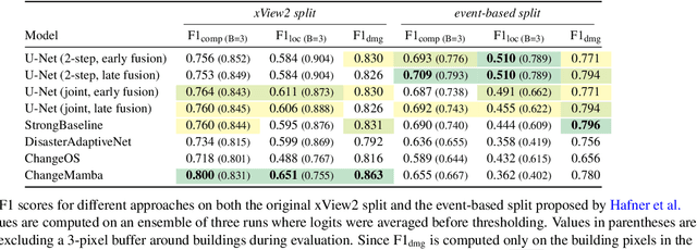

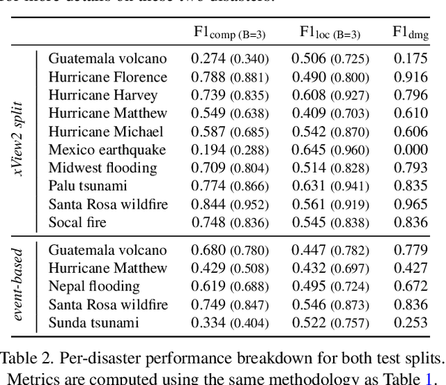
Abstract:Natural disasters demand rapid damage assessment to guide humanitarian response. Here, we investigate whether medium-resolution Earth observation images from the Copernicus program can support building damage assessment, complementing very-high resolution imagery with often limited availability. We introduce xBD-S12, a dataset of 10,315 pre- and post-disaster image pairs from both Sentinel-1 and Sentinel-2, spatially and temporally aligned with the established xBD benchmark. In a series of experiments, we demonstrate that building damage can be detected and mapped rather well in many disaster scenarios, despite the moderate 10$\,$m ground sampling distance. We also find that, for damage mapping at that resolution, architectural sophistication does not seem to bring much advantage: more complex model architectures tend to struggle with generalization to unseen disasters, and geospatial foundation models bring little practical benefit. Our results suggest that Copernicus images are a viable data source for rapid, wide-area damage assessment and could play an important role alongside VHR imagery. We release the xBD-S12 dataset, code, and trained models to support further research.
 Add to Chrome
 Add to Firefox
 Add to Edge