 Add to Chrome
 Add to Firefox
 Add to Edge
A Novel Solution for Drone Photogrammetry with Low-overlap Aerial Images using Monocular Depth Estimation
Mar 06, 2025


Low-overlap aerial imagery poses significant challenges to traditional photogrammetric methods, which rely heavily on high image overlap to produce accurate and complete mapping products. In this study, we propose a novel workflow based on monocular depth estimation to address the limitations of conventional techniques. Our method leverages tie points obtained from aerial triangulation to establish a relationship between monocular depth and metric depth, thus transforming the original depth map into a metric depth map, enabling the generation of dense depth information and the comprehensive reconstruction of the scene. For the experiments, a high-overlap drone dataset containing 296 images is processed using Metashape to generate depth maps and DSMs as ground truth. Subsequently, we create a low-overlap dataset by selecting 20 images for experimental evaluation. Results demonstrate that while the recovered depth maps and resulting DSMs achieve meter-level accuracy, they provide significantly better completeness compared to traditional methods, particularly in regions covered by single images. This study showcases the potential of monocular depth estimation in low-overlap aerial photogrammetry.
Cutting-edge 3D reconstruction solutions for underwater coral reef images: A review and comparison
Feb 27, 2025Corals serve as the foundational habitat-building organisms within reef ecosystems, constructing extensive structures that extend over vast distances. However, their inherent fragility and vulnerability to various threats render them susceptible to significant damage and destruction. The application of advanced 3D reconstruction technologies for high-quality modeling is crucial for preserving them. These technologies help scientists to accurately document and monitor the state of coral reefs, including their structure, species distribution and changes over time. Photogrammetry-based approaches stand out among existing solutions, especially with recent advancements in underwater videography, photogrammetric computer vision, and machine learning. Despite continuous progress in image-based 3D reconstruction techniques, there remains a lack of systematic reviews and comprehensive evaluations of cutting-edge solutions specifically applied to underwater coral reef images. The emerging advanced methods may have difficulty coping with underwater imaging environments, complex coral structures, and computational resource constraints. They need to be reviewed and evaluated to bridge the gap between many cutting-edge technical studies and practical applications. This paper focuses on the two critical stages of these approaches: camera pose estimation and dense surface reconstruction. We systematically review and summarize classical and emerging methods, conducting comprehensive evaluations through real-world and simulated datasets. Based on our findings, we offer reference recommendations and discuss the development potential and challenges of existing approaches in depth. This work equips scientists and managers with a technical foundation and practical guidance for processing underwater coral reef images for 3D reconstruction....
Quality assessment of image matchers for DSM generation -- a comparative study based on UAV images
Aug 18, 2021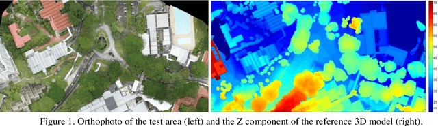

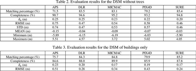
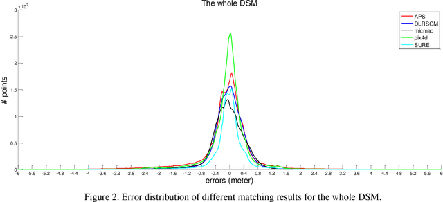
Recently developed automatic dense image matching algorithms are now being implemented for DSM/DTM production, with their pixel-level surface generation capability offering the prospect of partially alleviating the need for manual and semi-automatic stereoscopic measurements. In this paper, five commercial/public software packages for 3D surface generation are evaluated, using 5cm GSD imagery recorded from a UAV. Generated surface models are assessed against point clouds generated from mobile LiDAR and manual stereoscopic measurements. The software packages considered are APS, MICMAC, SURE, Pix4UAV and an SGM implementation from DLR.