Linus Scheibenreif
The Potential of Copernicus Satellites for Disaster Response: Retrieving Building Damage from Sentinel-1 and Sentinel-2
Nov 07, 2025
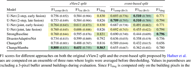

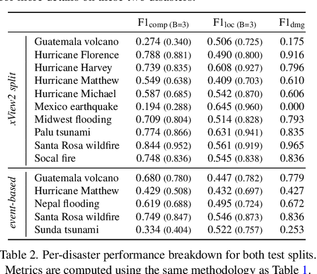
Abstract:Natural disasters demand rapid damage assessment to guide humanitarian response. Here, we investigate whether medium-resolution Earth observation images from the Copernicus program can support building damage assessment, complementing very-high resolution imagery with often limited availability. We introduce xBD-S12, a dataset of 10,315 pre- and post-disaster image pairs from both Sentinel-1 and Sentinel-2, spatially and temporally aligned with the established xBD benchmark. In a series of experiments, we demonstrate that building damage can be detected and mapped rather well in many disaster scenarios, despite the moderate 10$\,$m ground sampling distance. We also find that, for damage mapping at that resolution, architectural sophistication does not seem to bring much advantage: more complex model architectures tend to struggle with generalization to unseen disasters, and geospatial foundation models bring little practical benefit. Our results suggest that Copernicus images are a viable data source for rapid, wide-area damage assessment and could play an important role alongside VHR imagery. We release the xBD-S12 dataset, code, and trained models to support further research.
MAPEX: Modality-Aware Pruning of Experts for Remote Sensing Foundation Models
Jul 10, 2025Abstract:Remote sensing data is commonly used for tasks such as flood mapping, wildfire detection, or land-use studies. For each task, scientists carefully choose appropriate modalities or leverage data from purpose-built instruments. Recent work on remote sensing foundation models pre-trains computer vision models on large amounts of remote sensing data. These large-scale models tend to focus on specific modalities, often optical RGB or multispectral data. For many important applications, this introduces a mismatch between the application modalities and the pre-training data. Moreover, the large size of foundation models makes them expensive and difficult to fine-tune on typically small datasets for each task. We address this mismatch with MAPEX, a remote sensing foundation model based on mixture-of-modality experts. MAPEX is pre-trained on multi-modal remote sensing data with a novel modality-conditioned token routing mechanism that elicits modality-specific experts. To apply the model on a specific task, we propose a modality aware pruning technique, which only retains experts specialized for the task modalities. This yields efficient modality-specific models while simplifying fine-tuning and deployment for the modalities of interest. We experimentally validate MAPEX on diverse remote sensing datasets and show strong performance compared to fully supervised training and state-of-the-art remote sensing foundation models. Code is available at https://github.com/HSG-AIML/MAPEX.
Fine-tune Smarter, Not Harder: Parameter-Efficient Fine-Tuning for Geospatial Foundation Models
Apr 24, 2025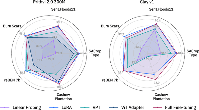
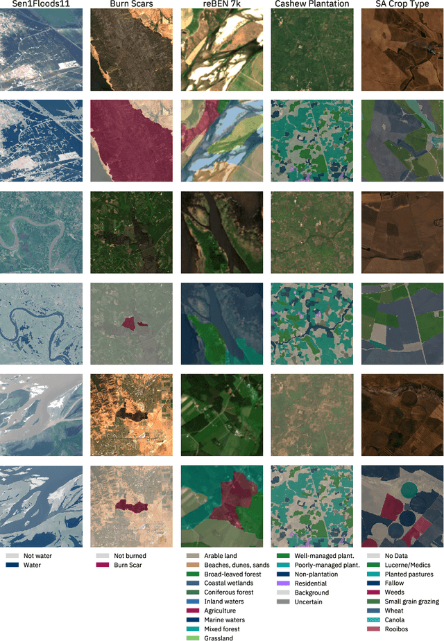
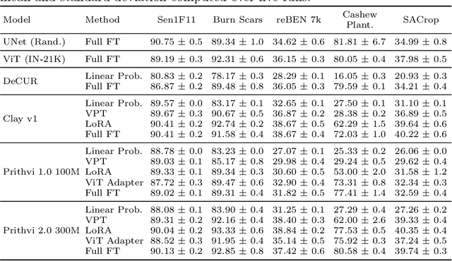

Abstract:Earth observation (EO) is crucial for monitoring environmental changes, responding to disasters, and managing natural resources. In this context, foundation models facilitate remote sensing image analysis to retrieve relevant geoinformation accurately and efficiently. However, as these models grow in size, fine-tuning becomes increasingly challenging due to the associated computational resources and costs, limiting their accessibility and scalability. Furthermore, full fine-tuning can lead to forgetting pre-trained features and even degrade model generalization. To address this, Parameter-Efficient Fine-Tuning (PEFT) techniques offer a promising solution. In this paper, we conduct extensive experiments with various foundation model architectures and PEFT techniques to evaluate their effectiveness on five different EO datasets. Our results provide a comprehensive comparison, offering insights into when and how PEFT methods support the adaptation of pre-trained geospatial models. We demonstrate that PEFT techniques match or even exceed full fine-tuning performance and enhance model generalisation to unseen geographic regions, while reducing training time and memory requirements. Additional experiments investigate the effect of architecture choices such as the decoder type or the use of metadata, suggesting UNet decoders and fine-tuning without metadata as the recommended configuration. We have integrated all evaluated foundation models and techniques into the open-source package TerraTorch to support quick, scalable, and cost-effective model adaptation.
Dense Air Pollution Estimation from Sparse in-situ Measurements and Satellite Data
Apr 23, 2025Abstract:This paper addresses the critical environmental challenge of estimating ambient Nitrogen Dioxide (NO$_2$) concentrations, a key issue in public health and environmental policy. Existing methods for satellite-based air pollution estimation model the relationship between satellite and in-situ measurements at select point locations. While these approaches have advanced our ability to provide air quality estimations on a global scale, they come with inherent limitations. The most notable limitation is the computational intensity required for generating comprehensive estimates over extensive areas. Motivated by these limitations, this study introduces a novel dense estimation technique. Our approach seeks to balance the accuracy of high-resolution estimates with the practicality of computational constraints, thereby enabling efficient and scalable global environmental assessment. By utilizing a uniformly random offset sampling strategy, our method disperses the ground truth data pixel location evenly across a larger patch. At inference, the dense estimation method can then generate a grid of estimates in a single step, significantly reducing the computational resources required to provide estimates for larger areas. Notably, our approach also surpasses the results of existing point-wise methods by a significant margin of $9.45\%$, achieving a Mean Absolute Error (MAE) of $4.98\ \mu\text{g}/\text{m}^3$. This demonstrates both high accuracy and computational efficiency, highlighting the applicability of our method for global environmental assessment. Furthermore, we showcase the method's adaptability and robustness by applying it to diverse geographic regions. Our method offers a viable solution to the computational challenges of large-scale environmental monitoring.
Hyperspectral Vision Transformers for Greenhouse Gas Estimations from Space
Apr 23, 2025Abstract:Hyperspectral imaging provides detailed spectral information and holds significant potential for monitoring of greenhouse gases (GHGs). However, its application is constrained by limited spatial coverage and infrequent revisit times. In contrast, multispectral imaging offers broader spatial and temporal coverage but often lacks the spectral detail that can enhance GHG detection. To address these challenges, this study proposes a spectral transformer model that synthesizes hyperspectral data from multispectral inputs. The model is pre-trained via a band-wise masked autoencoder and subsequently fine-tuned on spatio-temporally aligned multispectral-hyperspectral image pairs. The resulting synthetic hyperspectral data retain the spatial and temporal benefits of multispectral imagery and improve GHG prediction accuracy relative to using multispectral data alone. This approach effectively bridges the trade-off between spectral resolution and coverage, highlighting its potential to advance atmospheric monitoring by combining the strengths of hyperspectral and multispectral systems with self-supervised deep learning.
Ben-ge: Extending BigEarthNet with Geographical and Environmental Data
Jul 04, 2023Abstract:Deep learning methods have proven to be a powerful tool in the analysis of large amounts of complex Earth observation data. However, while Earth observation data are multi-modal in most cases, only single or few modalities are typically considered. In this work, we present the ben-ge dataset, which supplements the BigEarthNet-MM dataset by compiling freely and globally available geographical and environmental data. Based on this dataset, we showcase the value of combining different data modalities for the downstream tasks of patch-based land-use/land-cover classification and land-use/land-cover segmentation. ben-ge is freely available and expected to serve as a test bed for fully supervised and self-supervised Earth observation applications.
Invariant Risk Minimisation for Cross-Organism Inference: Substituting Mouse Data for Human Data in Human Risk Factor Discovery
Nov 14, 2021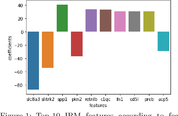
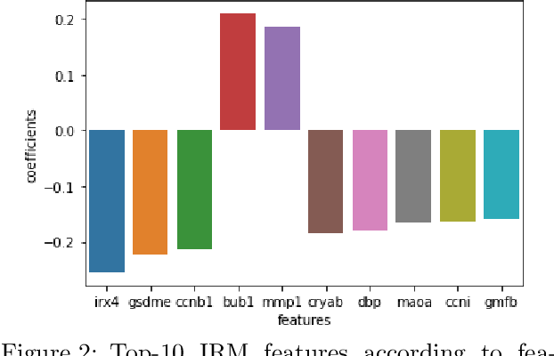
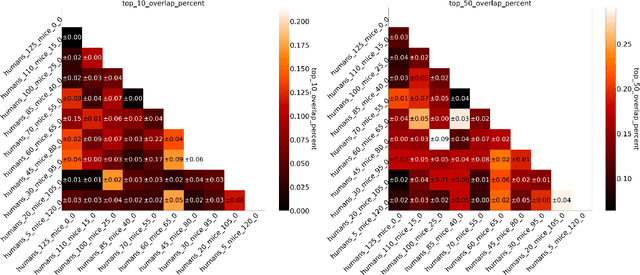
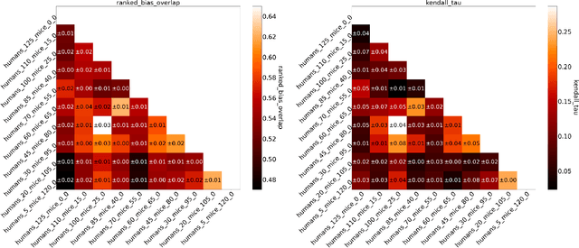
Abstract:Human medical data can be challenging to obtain due to data privacy concerns, difficulties conducting certain types of experiments, or prohibitive associated costs. In many settings, data from animal models or in-vitro cell lines are available to help augment our understanding of human data. However, this data is known for having low etiological validity in comparison to human data. In this work, we augment small human medical datasets with in-vitro data and animal models. We use Invariant Risk Minimisation (IRM) to elucidate invariant features by considering cross-organism data as belonging to different data-generating environments. Our models identify genes of relevance to human cancer development. We observe a degree of consistency between varying the amounts of human and mouse data used, however, further work is required to obtain conclusive insights. As a secondary contribution, we enhance existing open source datasets and provide two uniformly processed, cross-organism, homologue gene-matched datasets to the community.
Estimation of Air Pollution with Remote Sensing Data: Revealing Greenhouse Gas Emissions from Space
Aug 31, 2021


Abstract:Air pollution is a major driver of climate change. Anthropogenic emissions from the burning of fossil fuels for transportation and power generation emit large amounts of problematic air pollutants, including Greenhouse Gases (GHGs). Despite the importance of limiting GHG emissions to mitigate climate change, detailed information about the spatial and temporal distribution of GHG and other air pollutants is difficult to obtain. Existing models for surface-level air pollution rely on extensive land-use datasets which are often locally restricted and temporally static. This work proposes a deep learning approach for the prediction of ambient air pollution that only relies on remote sensing data that is globally available and frequently updated. Combining optical satellite imagery with satellite-based atmospheric column density air pollution measurements enables the scaling of air pollution estimates (in this case NO$_2$) to high spatial resolution (up to $\sim$10m) at arbitrary locations and adds a temporal component to these estimates. The proposed model performs with high accuracy when evaluated against air quality measurements from ground stations (mean absolute error $<$6$~\mu g/m^3$). Our results enable the identification and temporal monitoring of major sources of air pollution and GHGs.
Power Plant Classification from Remote Imaging with Deep Learning
Jul 22, 2021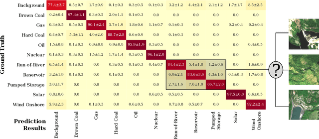

Abstract:Satellite remote imaging enables the detailed study of land use patterns on a global scale. We investigate the possibility to improve the information content of traditional land use classification by identifying the nature of industrial sites from medium-resolution remote sensing images. In this work, we focus on classifying different types of power plants from Sentinel-2 imaging data. Using a ResNet-50 deep learning model, we are able to achieve a mean accuracy of 90.0% in distinguishing 10 different power plant types and a background class. Furthermore, we are able to identify the cooling mechanisms utilized in thermal power plants with a mean accuracy of 87.5%. Our results enable us to qualitatively investigate the energy mix from Sentinel-2 imaging data, and prove the feasibility to classify industrial sites on a global scale from freely available satellite imagery.
Characterization of Industrial Smoke Plumes from Remote Sensing Data
Nov 23, 2020


Abstract:The major driver of global warming has been identified as the anthropogenic release of greenhouse gas (GHG) emissions from industrial activities. The quantitative monitoring of these emissions is mandatory to fully understand their effect on the Earth's climate and to enforce emission regulations on a large scale. In this work, we investigate the possibility to detect and quantify industrial smoke plumes from globally and freely available multi-band image data from ESA's Sentinel-2 satellites. Using a modified ResNet-50, we can detect smoke plumes of different sizes with an accuracy of 94.3%. The model correctly ignores natural clouds and focuses on those imaging channels that are related to the spectral absorption from aerosols and water vapor, enabling the localization of smoke. We exploit this localization ability and train a U-Net segmentation model on a labeled sub-sample of our data, resulting in an Intersection-over-Union (IoU) metric of 0.608 and an overall accuracy for the detection of any smoke plume of 94.0%; on average, our model can reproduce the area covered by smoke in an image to within 5.6%. The performance of our model is mostly limited by occasional confusion with surface objects, the inability to identify semi-transparent smoke, and human limitations to properly identify smoke based on RGB-only images. Nevertheless, our results enable us to reliably detect and qualitatively estimate the level of smoke activity in order to monitor activity in industrial plants across the globe. Our data set and code base are publicly available.
 Add to Chrome
 Add to Firefox
 Add to Edge