 Add to Chrome
 Add to Firefox
 Add to Edge
The Potential of Copernicus Satellites for Disaster Response: Retrieving Building Damage from Sentinel-1 and Sentinel-2
Nov 07, 2025
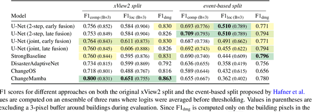

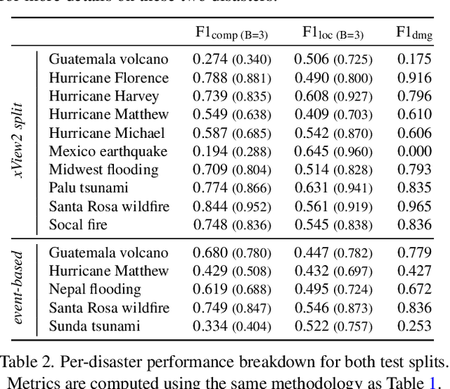
Natural disasters demand rapid damage assessment to guide humanitarian response. Here, we investigate whether medium-resolution Earth observation images from the Copernicus program can support building damage assessment, complementing very-high resolution imagery with often limited availability. We introduce xBD-S12, a dataset of 10,315 pre- and post-disaster image pairs from both Sentinel-1 and Sentinel-2, spatially and temporally aligned with the established xBD benchmark. In a series of experiments, we demonstrate that building damage can be detected and mapped rather well in many disaster scenarios, despite the moderate 10$\,$m ground sampling distance. We also find that, for damage mapping at that resolution, architectural sophistication does not seem to bring much advantage: more complex model architectures tend to struggle with generalization to unseen disasters, and geospatial foundation models bring little practical benefit. Our results suggest that Copernicus images are a viable data source for rapid, wide-area damage assessment and could play an important role alongside VHR imagery. We release the xBD-S12 dataset, code, and trained models to support further research.
BRIGHT: A globally distributed multimodal building damage assessment dataset with very-high-resolution for all-weather disaster response
Jan 10, 2025


Disaster events occur around the world and cause significant damage to human life and property. Earth observation (EO) data enables rapid and comprehensive building damage assessment (BDA), an essential capability in the aftermath of a disaster to reduce human casualties and to inform disaster relief efforts. Recent research focuses on the development of AI models to achieve accurate mapping of unseen disaster events, mostly using optical EO data. However, solutions based on optical data are limited to clear skies and daylight hours, preventing a prompt response to disasters. Integrating multimodal (MM) EO data, particularly the combination of optical and SAR imagery, makes it possible to provide all-weather, day-and-night disaster responses. Despite this potential, the development of robust multimodal AI models has been constrained by the lack of suitable benchmark datasets. In this paper, we present a BDA dataset using veRy-hIGH-resoluTion optical and SAR imagery (BRIGHT) to support AI-based all-weather disaster response. To the best of our knowledge, BRIGHT is the first open-access, globally distributed, event-diverse MM dataset specifically curated to support AI-based disaster response. It covers five types of natural disasters and two types of man-made disasters across 12 regions worldwide, with a particular focus on developing countries where external assistance is most needed. The optical and SAR imagery in BRIGHT, with a spatial resolution between 0.3-1 meters, provides detailed representations of individual buildings, making it ideal for precise BDA. In our experiments, we have tested seven advanced AI models trained with our BRIGHT to validate the transferability and robustness. The dataset and code are available at https://github.com/ChenHongruixuan/BRIGHT. BRIGHT also serves as the official dataset for the 2025 IEEE GRSS Data Fusion Contest.
An Open-Source Tool for Mapping War Destruction at Scale in Ukraine using Sentinel-1 Time Series
Jun 04, 2024


Access to detailed war impact assessments is crucial for humanitarian organizations to effectively assist populations most affected by armed conflicts. However, maintaining a comprehensive understanding of the situation on the ground is challenging, especially in conflicts that cover vast territories and extend over long periods. This study presents a scalable and transferable method for estimating war-induced damage to buildings. We first train a machine learning model to output pixel-wise probability of destruction from Synthetic Aperture Radar (SAR) satellite image time series, leveraging existing, manual damage assessments as ground truth and cloud-based geospatial analysis tools for large-scale inference. We further post-process these assessments using open building footprints to obtain a final damage estimate per building. We introduce an accessible, open-source tool that allows users to adjust the confidence interval based on their specific requirements and use cases. Our approach enables humanitarian organizations and other actors to rapidly screen large geographic regions for war impacts. We provide two publicly accessible dashboards: a Ukraine Damage Explorer to dynamically view our pre-computed estimates, and a Rapid Damage Mapping Tool to easily run our method and produce custom maps.