Bharath Hariharan
Cornell University
MovieRecapsQA: A Multimodal Open-Ended Video Question-Answering Benchmark
Jan 05, 2026Abstract:Understanding real-world videos such as movies requires integrating visual and dialogue cues to answer complex questions. Yet existing VideoQA benchmarks struggle to capture this multimodal reasoning and are largely not open-ended, given the difficulty of evaluating free-form answers. In this paper, we introduce a novel open-ended multi-modal VideoQA benchmark, MovieRecapsQA created using movie recap videos--a distinctive type of YouTube content that summarizes a film by presenting its key events through synchronized visual (recap video) and textual (recap summary) modalities. Using the recap summary, we generate $\approx 8.2$ K question-answer (QA) pairs (aligned with movie-subtitles) and provide the necessary "facts" needed to verify an answer in a reference-free manner. To our knowledge, this is the first open-ended VideoQA benchmark that supplies explicit textual context of the input (video and/or text); which we use for evaluation. Our benchmark provides videos of multiple lengths (i.e., recap-segments, movie-segments) and categorizations of questions (by modality and type) to enable fine-grained analysis. We evaluate the performance of seven state-of-the-art MLLMs using our benchmark and observe that: 1) visual-only questions remain the most challenging; 2) models default to textual inputs whenever available; 3) extracting factually accurate information from video content is still difficult for all models; and 4) proprietary and open-source models perform comparably on video-dependent questions.
Tracking and Understanding Object Transformations
Nov 06, 2025Abstract:Real-world objects frequently undergo state transformations. From an apple being cut into pieces to a butterfly emerging from its cocoon, tracking through these changes is important for understanding real-world objects and dynamics. However, existing methods often lose track of the target object after transformation, due to significant changes in object appearance. To address this limitation, we introduce the task of Track Any State: tracking objects through transformations while detecting and describing state changes, accompanied by a new benchmark dataset, VOST-TAS. To tackle this problem, we present TubeletGraph, a zero-shot system that recovers missing objects after transformation and maps out how object states are evolving over time. TubeletGraph first identifies potentially overlooked tracks, and determines whether they should be integrated based on semantic and proximity priors. Then, it reasons about the added tracks and generates a state graph describing each observed transformation. TubeletGraph achieves state-of-the-art tracking performance under transformations, while demonstrating deeper understanding of object transformations and promising capabilities in temporal grounding and semantic reasoning for complex object transformations. Code, additional results, and the benchmark dataset are available at https://tubelet-graph.github.io.
Not Every Gift Comes in Gold Paper or with a Red Ribbon: Exploring Color Perception in Text-to-Image Models
Aug 27, 2025Abstract:Text-to-image generation has recently seen remarkable success, granting users with the ability to create high-quality images through the use of text. However, contemporary methods face challenges in capturing the precise semantics conveyed by complex multi-object prompts. Consequently, many works have sought to mitigate such semantic misalignments, typically via inference-time schemes that modify the attention layers of the denoising networks. However, prior work has mostly utilized coarse metrics, such as the cosine similarity between text and image CLIP embeddings, or human evaluations, which are challenging to conduct on a larger-scale. In this work, we perform a case study on colors -- a fundamental attribute commonly associated with objects in text prompts, which offer a rich test bed for rigorous evaluation. Our analysis reveals that pretrained models struggle to generate images that faithfully reflect multiple color attributes-far more so than with single-color prompts-and that neither inference-time techniques nor existing editing methods reliably resolve these semantic misalignments. Accordingly, we introduce a dedicated image editing technique, mitigating the issue of multi-object semantic alignment for prompts containing multiple colors. We demonstrate that our approach significantly boosts performance over a wide range of metrics, considering images generated by various text-to-image diffusion-based techniques.
RanDeS: Randomized Delta Superposition for Multi-Model Compression
May 16, 2025Abstract:From a multi-model compression perspective, model merging enables memory-efficient serving of multiple models fine-tuned from the same base, but suffers from degraded performance due to interference among their task-specific parameter adjustments (i.e., deltas). In this paper, we reformulate model merging as a compress-and-retrieve scheme, revealing that the task interference arises from the summation of irrelevant deltas during model retrieval. To address this issue, we use random orthogonal transformations to decorrelate these vectors into self-cancellation. We show that this approach drastically reduces interference, improving performance across both vision and language tasks. Since these transformations are fully defined by random seeds, adding new models requires no extra memory. Further, their data- and model-agnostic nature enables easy addition or removal of models with minimal compute overhead, supporting efficient and flexible multi-model serving.
Towards LLM Agents for Earth Observation
Apr 16, 2025Abstract:Earth Observation (EO) provides critical planetary data for environmental monitoring, disaster management, climate science, and other scientific domains. Here we ask: Are AI systems ready for reliable Earth Observation? We introduce \datasetnamenospace, a benchmark of 140 yes/no questions from NASA Earth Observatory articles across 13 topics and 17 satellite sensors. Using Google Earth Engine API as a tool, LLM agents can only achieve an accuracy of 33% because the code fails to run over 58% of the time. We improve the failure rate for open models by fine-tuning synthetic data, allowing much smaller models (Llama-3.1-8B) to achieve comparable accuracy to much larger ones (e.g., DeepSeek-R1). Taken together, our findings identify significant challenges to be solved before AI agents can automate earth observation, and suggest paths forward. The project page is available at https://iandrover.github.io/UnivEarth.
FlashDepth: Real-time Streaming Video Depth Estimation at 2K Resolution
Apr 09, 2025Abstract:A versatile video depth estimation model should (1) be accurate and consistent across frames, (2) produce high-resolution depth maps, and (3) support real-time streaming. We propose FlashDepth, a method that satisfies all three requirements, performing depth estimation on a 2044x1148 streaming video at 24 FPS. We show that, with careful modifications to pretrained single-image depth models, these capabilities are enabled with relatively little data and training. We evaluate our approach across multiple unseen datasets against state-of-the-art depth models, and find that ours outperforms them in terms of boundary sharpness and speed by a significant margin, while maintaining competitive accuracy. We hope our model will enable various applications that require high-resolution depth, such as video editing, and online decision-making, such as robotics.
Mixed Signals: A Diverse Point Cloud Dataset for Heterogeneous LiDAR V2X Collaboration
Feb 19, 2025Abstract:Vehicle-to-everything (V2X) collaborative perception has emerged as a promising solution to address the limitations of single-vehicle perception systems. However, existing V2X datasets are limited in scope, diversity, and quality. To address these gaps, we present Mixed Signals, a comprehensive V2X dataset featuring 45.1k point clouds and 240.6k bounding boxes collected from three connected autonomous vehicles (CAVs) equipped with two different types of LiDAR sensors, plus a roadside unit with dual LiDARs. Our dataset provides precisely aligned point clouds and bounding box annotations across 10 classes, ensuring reliable data for perception training. We provide detailed statistical analysis on the quality of our dataset and extensively benchmark existing V2X methods on it. Mixed Signals V2X Dataset is one of the highest quality, large-scale datasets publicly available for V2X perception research. Details on the website https://mixedsignalsdataset.cs.cornell.edu/.
Transfer Your Perspective: Controllable 3D Generation from Any Viewpoint in a Driving Scene
Feb 10, 2025


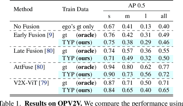
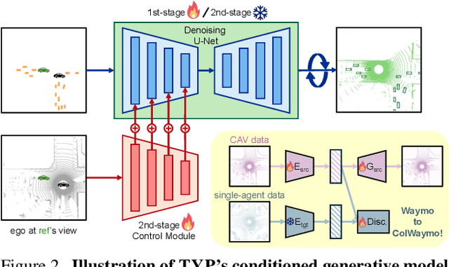
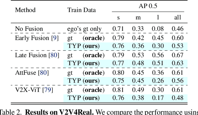
Abstract:Self-driving cars relying solely on ego-centric perception face limitations in sensing, often failing to detect occluded, faraway objects. Collaborative autonomous driving (CAV) seems like a promising direction, but collecting data for development is non-trivial. It requires placing multiple sensor-equipped agents in a real-world driving scene, simultaneously! As such, existing datasets are limited in locations and agents. We introduce a novel surrogate to the rescue, which is to generate realistic perception from different viewpoints in a driving scene, conditioned on a real-world sample - the ego-car's sensory data. This surrogate has huge potential: it could potentially turn any ego-car dataset into a collaborative driving one to scale up the development of CAV. We present the very first solution, using a combination of simulated collaborative data and real ego-car data. Our method, Transfer Your Perspective (TYP), learns a conditioned diffusion model whose output samples are not only realistic but also consistent in both semantics and layouts with the given ego-car data. Empirical results demonstrate TYP's effectiveness in aiding in a CAV setting. In particular, TYP enables us to (pre-)train collaborative perception algorithms like early and late fusion with little or no real-world collaborative data, greatly facilitating downstream CAV applications.
Video Creation by Demonstration
Dec 12, 2024


Abstract:We explore a novel video creation experience, namely Video Creation by Demonstration. Given a demonstration video and a context image from a different scene, we generate a physically plausible video that continues naturally from the context image and carries out the action concepts from the demonstration. To enable this capability, we present $\delta$-Diffusion, a self-supervised training approach that learns from unlabeled videos by conditional future frame prediction. Unlike most existing video generation controls that are based on explicit signals, we adopts the form of implicit latent control for maximal flexibility and expressiveness required by general videos. By leveraging a video foundation model with an appearance bottleneck design on top, we extract action latents from demonstration videos for conditioning the generation process with minimal appearance leakage. Empirically, $\delta$-Diffusion outperforms related baselines in terms of both human preference and large-scale machine evaluations, and demonstrates potentials towards interactive world simulation. Sampled video generation results are available at https://delta-diffusion.github.io/.
Generating 3D-Consistent Videos from Unposed Internet Photos
Nov 20, 2024


Abstract:We address the problem of generating videos from unposed internet photos. A handful of input images serve as keyframes, and our model interpolates between them to simulate a path moving between the cameras. Given random images, a model's ability to capture underlying geometry, recognize scene identity, and relate frames in terms of camera position and orientation reflects a fundamental understanding of 3D structure and scene layout. However, existing video models such as Luma Dream Machine fail at this task. We design a self-supervised method that takes advantage of the consistency of videos and variability of multiview internet photos to train a scalable, 3D-aware video model without any 3D annotations such as camera parameters. We validate that our method outperforms all baselines in terms of geometric and appearance consistency. We also show our model benefits applications that enable camera control, such as 3D Gaussian Splatting. Our results suggest that we can scale up scene-level 3D learning using only 2D data such as videos and multiview internet photos.
 Add to Chrome
 Add to Firefox
 Add to Edge