Shreyas Kousik
Stanford University
A Closed-Form Geometric Retargeting Solver for Upper Body Humanoid Robot Teleoperation
Feb 02, 2026Abstract:Retargeting human motion to robot poses is a practical approach for teleoperating bimanual humanoid robot arms, but existing methods can be suboptimal and slow, often causing undesirable motion or latency. This is due to optimizing to match robot end-effector to human hand position and orientation, which can also limit the robot's workspace to that of the human. Instead, this paper reframes retargeting as an orientation alignment problem, enabling a closed-form, geometric solution algorithm with an optimality guarantee. The key idea is to align a robot arm to a human's upper and lower arm orientations, as identified from shoulder, elbow, and wrist (SEW) keypoints; hence, the method is called SEW-Mimic. The method has fast inference (3 kHz) on standard commercial CPUs, leaving computational overhead for downstream applications; an example in this paper is a safety filter to avoid bimanual self-collision. The method suits most 7-degree-of-freedom robot arms and humanoids, and is agnostic to input keypoint source. Experiments show that SEW-Mimic outperforms other retargeting methods in computation time and accuracy. A pilot user study suggests that the method improves teleoperation task success. Preliminary analysis indicates that data collected with SEW-Mimic improves policy learning due to being smoother. SEW-Mimic is also shown to be a drop-in way to accelerate full-body humanoid retargeting. Finally, hardware demonstrations illustrate SEW-Mimic's practicality. The results emphasize the utility of SEW-Mimic as a fundamental building block for bimanual robot manipulation and humanoid robot teleoperation.
Language Conditioning Improves Accuracy of Aircraft Goal Prediction in Untowered Airspace
Sep 17, 2025Abstract:Autonomous aircraft must safely operate in untowered airspace, where coordination relies on voice-based communication among human pilots. Safe operation requires an aircraft to predict the intent, and corresponding goal location, of other aircraft. This paper introduces a multimodal framework for aircraft goal prediction that integrates natural language understanding with spatial reasoning to improve autonomous decision-making in such environments. We leverage automatic speech recognition and large language models to transcribe and interpret pilot radio calls, identify aircraft, and extract discrete intent labels. These intent labels are fused with observed trajectories to condition a temporal convolutional network and Gaussian mixture model for probabilistic goal prediction. Our method significantly reduces goal prediction error compared to baselines that rely solely on motion history, demonstrating that language-conditioned prediction increases prediction accuracy. Experiments on a real-world dataset from an untowered airport validate the approach and highlight its potential to enable socially aware, language-conditioned robotic motion planning.
Joint Model-based Model-free Diffusion for Planning with Constraints
Sep 10, 2025Abstract:Model-free diffusion planners have shown great promise for robot motion planning, but practical robotic systems often require combining them with model-based optimization modules to enforce constraints, such as safety. Naively integrating these modules presents compatibility challenges when diffusion's multi-modal outputs behave adversarially to optimization-based modules. To address this, we introduce Joint Model-based Model-free Diffusion (JM2D), a novel generative modeling framework. JM2D formulates module integration as a joint sampling problem to maximize compatibility via an interaction potential, without additional training. Using importance sampling, JM2D guides modules outputs based only on evaluations of the interaction potential, thus handling non-differentiable objectives commonly arising from non-convex optimization modules. We evaluate JM2D via application to aligning diffusion planners with safety modules on offline RL and robot manipulation. JM2D significantly improves task performance compared to conventional safety filters without sacrificing safety. Further, we show that conditional generation is a special case of JM2D and elucidate key design choices by comparing with SOTA gradient-based and projection-based diffusion planners. More details at: https://jm2d-corl25.github.io/.
SAIL: Faster-than-Demonstration Execution of Imitation Learning Policies
Jun 13, 2025Abstract:Offline Imitation Learning (IL) methods such as Behavior Cloning are effective at acquiring complex robotic manipulation skills. However, existing IL-trained policies are confined to executing the task at the same speed as shown in demonstration data. This limits the task throughput of a robotic system, a critical requirement for applications such as industrial automation. In this paper, we introduce and formalize the novel problem of enabling faster-than-demonstration execution of visuomotor policies and identify fundamental challenges in robot dynamics and state-action distribution shifts. We instantiate the key insights as SAIL (Speed Adaptation for Imitation Learning), a full-stack system integrating four tightly-connected components: (1) a consistency-preserving action inference algorithm for smooth motion at high speed, (2) high-fidelity tracking of controller-invariant motion targets, (3) adaptive speed modulation that dynamically adjusts execution speed based on motion complexity, and (4) action scheduling to handle real-world system latencies. Experiments on 12 tasks across simulation and two real, distinct robot platforms show that SAIL achieves up to a 4x speedup over demonstration speed in simulation and up to 3.2x speedup in the real world. Additional detail is available at https://nadunranawaka1.github.io/sail-policy
Seeing, Saying, Solving: An LLM-to-TL Framework for Cooperative Robots
May 19, 2025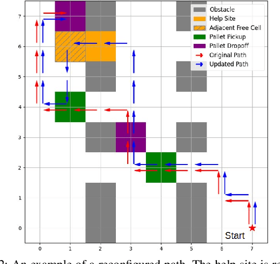
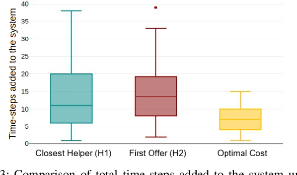
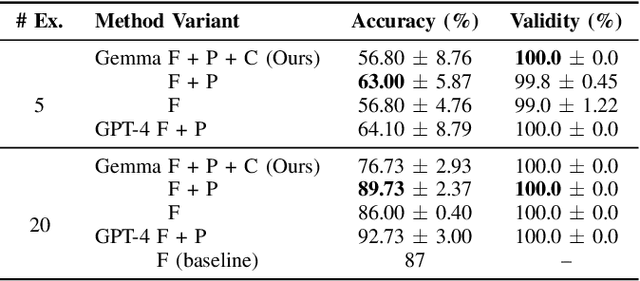
Abstract:Increased robot deployment, such as in warehousing, has revealed a need for seamless collaboration among heterogeneous robot teams to resolve unforeseen conflicts. To address this challenge, we propose a novel, decentralized framework for robots to request and provide help. The framework begins with robots detecting conflicts using a Vision Language Model (VLM), then reasoning over whether help is needed. If so, it crafts and broadcasts a natural language (NL) help request using a Large Language Model (LLM). Potential helper robots reason over the request and offer help (if able), along with information about impact to their current tasks. Helper reasoning is implemented via an LLM grounded in Signal Temporal Logic (STL) using a Backus-Naur Form (BNF) grammar to guarantee syntactically valid NL-to-STL translations, which are then solved as a Mixed Integer Linear Program (MILP). Finally, the requester robot chooses a helper by reasoning over impact on the overall system. We evaluate our system via experiments considering different strategies for choosing a helper, and find that a requester robot can minimize overall time impact on the system by considering multiple help offers versus simple heuristics (e.g., selecting the nearest robot to help).
RAIL: Reachability-Aided Imitation Learning for Safe Policy Execution
Sep 28, 2024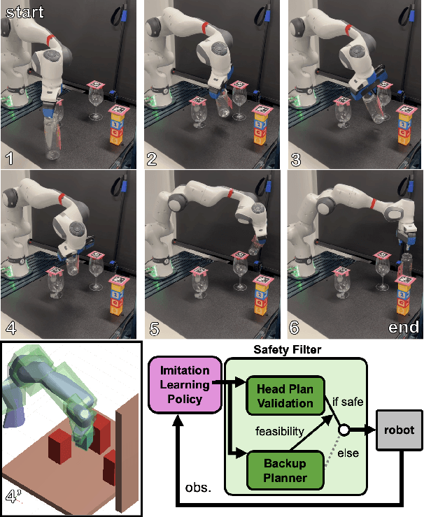
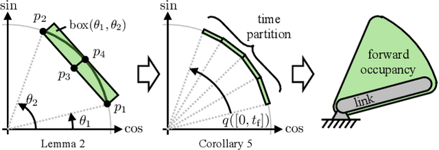


Abstract:Imitation learning (IL) has shown great success in learning complex robot manipulation tasks. However, there remains a need for practical safety methods to justify widespread deployment. In particular, it is important to certify that a system obeys hard constraints on unsafe behavior in settings when it is unacceptable to design a tradeoff between performance and safety via tuning the policy (i.e. soft constraints). This leads to the question, how does enforcing hard constraints impact the performance (meaning safely completing tasks) of an IL policy? To answer this question, this paper builds a reachability-based safety filter to enforce hard constraints on IL, which we call Reachability-Aided Imitation Learning (RAIL). Through evaluations with state-of-the-art IL policies in mobile robots and manipulation tasks, we make two key findings. First, the highest-performing policies are sometimes only so because they frequently violate constraints, and significantly lose performance under hard constraints. Second, surprisingly, hard constraints on the lower-performing policies can occasionally increase their ability to perform tasks safely. Finally, hardware evaluation confirms the method can operate in real time.
Socially Acceptable Bipedal Robot Navigation via Social Zonotope Network Model Predictive Control
Jun 24, 2024Abstract:This study addresses the challenge of social bipedal navigation in a dynamic, human-crowded environment, a research area largely underexplored in legged robot navigation. We present a zonotope-based framework that couples prediction and motion planning for a bipedal ego-agent to account for bidirectional influence with the surrounding pedestrians. This framework incorporates a Social Zonotope Network (SZN), a neural network that predicts future pedestrian reachable sets and plans future socially acceptable reachable set for the ego-agent. SZN generates the reachable sets as zonotopes for efficient reachability-based planning, collision checking, and online uncertainty parameterization. Locomotion-specific losses are added to the SZN training process to adhere to the dynamic limits of the bipedal robot that are not explicitly present in the human crowds data set. These loss functions enable the SZN to generate locomotion paths that are more dynamically feasible for improved tracking. SZN is integrated with a Model Predictive Controller (SZN-MPC) for footstep planning for our bipedal robot Digit. SZN-MPC solves for collision-free trajectory by optimizing through SZN's gradients. and Our results demonstrate the framework's effectiveness in producing a socially acceptable path, with consistent locomotion velocity, and optimality. The SZN-MPC framework is validated with extensive simulations and hardware experiments.
ZAPP! Zonotope Agreement of Prediction and Planning for Continuous-Time Collision Avoidance with Discrete-Time Dynamics
Jun 03, 2024Abstract:The past few years have seen immense progress on two fronts that are critical to safe, widespread mobile robot deployment: predicting uncertain motion of multiple agents, and planning robot motion under uncertainty. However, the numerical methods required on each front have resulted in a mismatch of representation for prediction and planning. In prediction, numerical tractability is usually achieved by coarsely discretizing time, and by representing multimodal multi-agent interactions as distributions with infinite support. On the other hand, safe planning typically requires very fine time discretization, paired with distributions with compact support, to reduce conservativeness and ensure numerical tractability. The result is, when existing predictors are coupled with planning and control, one may often find unsafe motion plans. This paper proposes ZAPP (Zonotope Agreement of Prediction and Planning) to resolve the representation mismatch. ZAPP unites a prediction-friendly coarse time discretization and a planning-friendly zonotope uncertainty representation; the method also enables differentiating through a zonotope collision check, allowing one to integrate prediction and planning within a gradient-based optimization framework. Numerical examples show how ZAPP can produce safer trajectories compared to baselines in interactive scenes.
Real-time Model Predictive Control with Zonotope-Based Neural Networks for Bipedal Social Navigation
Mar 25, 2024Abstract:This study addresses the challenge of bipedal navigation in a dynamic human-crowded environment, a research area that remains largely underexplored in the field of legged navigation. We propose two cascaded zonotope-based neural networks: a Pedestrian Prediction Network (PPN) for pedestrians' future trajectory prediction and an Ego-agent Social Network (ESN) for ego-agent social path planning. Representing future paths as zonotopes allows for efficient reachability-based planning and collision checking. The ESN is then integrated with a Model Predictive Controller (ESN-MPC) for footstep planning for our bipedal robot Digit designed by Agility Robotics. ESN-MPC solves for a collision-free optimal trajectory by optimizing through the gradients of ESN. ESN-MPC optimal trajectory is sent to the low-level controller for full-order simulation of Digit. The overall proposed framework is validated with extensive simulations on randomly generated initial settings with varying human crowd densities.
Mapping High-level Semantic Regions in Indoor Environments without Object Recognition
Mar 11, 2024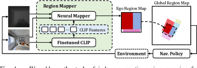
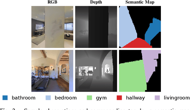
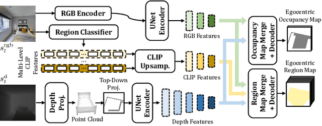
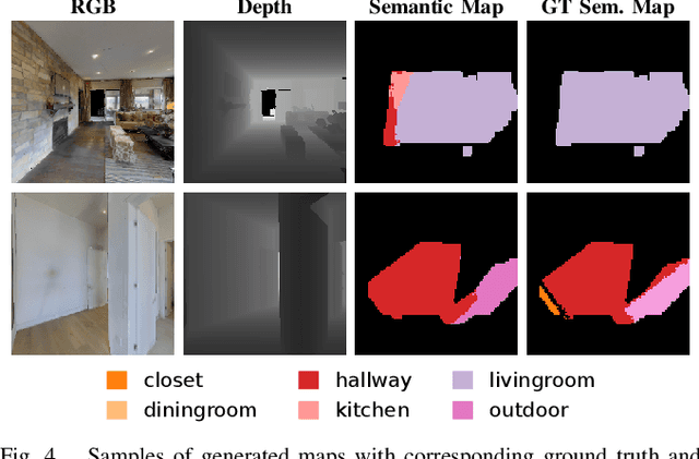
Abstract:Robots require a semantic understanding of their surroundings to operate in an efficient and explainable way in human environments. In the literature, there has been an extensive focus on object labeling and exhaustive scene graph generation; less effort has been focused on the task of purely identifying and mapping large semantic regions. The present work proposes a method for semantic region mapping via embodied navigation in indoor environments, generating a high-level representation of the knowledge of the agent. To enable region identification, the method uses a vision-to-language model to provide scene information for mapping. By projecting egocentric scene understanding into the global frame, the proposed method generates a semantic map as a distribution over possible region labels at each location. This mapping procedure is paired with a trained navigation policy to enable autonomous map generation. The proposed method significantly outperforms a variety of baselines, including an object-based system and a pretrained scene classifier, in experiments in a photorealistic simulator.
 Add to Chrome
 Add to Firefox
 Add to Edge