 Add to Chrome
 Add to Firefox
 Add to Edge
Mind-Brush: Integrating Agentic Cognitive Search and Reasoning into Image Generation
Feb 02, 2026While text-to-image generation has achieved unprecedented fidelity, the vast majority of existing models function fundamentally as static text-to-pixel decoders. Consequently, they often fail to grasp implicit user intentions. Although emerging unified understanding-generation models have improved intent comprehension, they still struggle to accomplish tasks involving complex knowledge reasoning within a single model. Moreover, constrained by static internal priors, these models remain unable to adapt to the evolving dynamics of the real world. To bridge these gaps, we introduce Mind-Brush, a unified agentic framework that transforms generation into a dynamic, knowledge-driven workflow. Simulating a human-like 'think-research-create' paradigm, Mind-Brush actively retrieves multimodal evidence to ground out-of-distribution concepts and employs reasoning tools to resolve implicit visual constraints. To rigorously evaluate these capabilities, we propose Mind-Bench, a comprehensive benchmark comprising 500 distinct samples spanning real-time news, emerging concepts, and domains such as mathematical and Geo-Reasoning. Extensive experiments demonstrate that Mind-Brush significantly enhances the capabilities of unified models, realizing a zero-to-one capability leap for the Qwen-Image baseline on Mind-Bench, while achieving superior results on established benchmarks like WISE and RISE.
IPCV: Information-Preserving Compression for MLLM Visual Encoders
Dec 21, 2025


Multimodal Large Language Models (MLLMs) deliver strong vision-language performance but at high computational cost, driven by numerous visual tokens processed by the Vision Transformer (ViT) encoder. Existing token pruning strategies are inadequate: LLM-stage token pruning overlooks the ViT's overhead, while conventional ViT token pruning, without language guidance, risks discarding textually critical visual cues and introduces feature distortions amplified by the ViT's bidirectional attention. To meet these challenges, we propose IPCV, a training-free, information-preserving compression framework for MLLM visual encoders. IPCV enables aggressive token pruning inside the ViT via Neighbor-Guided Reconstruction (NGR) that temporarily reconstructs pruned tokens to participate in attention with minimal overhead, then fully restores them before passing to the LLM. Besides, we introduce Attention Stabilization (AS) to further alleviate the negative influence from token pruning by approximating the K/V of pruned tokens. It can be directly applied to previous LLM-side token pruning methods to enhance their performance. Extensive experiments show that IPCV substantially reduces end-to-end computation and outperforms state-of-the-art training-free token compression methods across diverse image and video benchmarks. Our code is available at https://github.com/Perkzi/IPCV.
OmniAID: Decoupling Semantic and Artifacts for Universal AI-Generated Image Detection in the Wild
Nov 11, 2025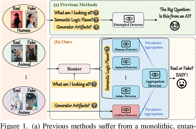
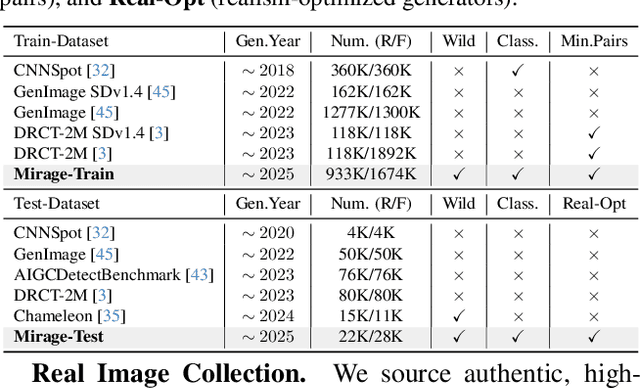
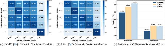
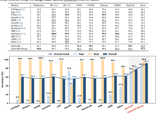
A truly universal AI-Generated Image (AIGI) detector must simultaneously generalize across diverse generative models and varied semantic content. Current state-of-the-art methods learn a single, entangled forgery representation--conflating content-dependent flaws with content-agnostic artifacts--and are further constrained by outdated benchmarks. To overcome these limitations, we propose OmniAID, a novel framework centered on a decoupled Mixture-of-Experts (MoE) architecture. The core of our method is a hybrid expert system engineered to decouple: (1) semantic flaws across distinct content domains, and (2) these content-dependent flaws from content-agnostic universal artifacts. This system employs a set of Routable Specialized Semantic Experts, each for a distinct domain (e.g., human, animal), complemented by a Fixed Universal Artifact Expert. This architecture is trained using a bespoke two-stage strategy: we first train the experts independently with domain-specific hard-sampling to ensure specialization, and subsequently train a lightweight gating network for effective input routing. By explicitly decoupling "what is generated" (content-specific flaws) from "how it is generated" (universal artifacts), OmniAID achieves robust generalization. To address outdated benchmarks and validate real-world applicability, we introduce Mirage, a new large-scale, contemporary dataset. Extensive experiments, using both traditional benchmarks and our Mirage dataset, demonstrate our model surpasses existing monolithic detectors, establishing a new, robust standard for AIGI authentication against modern, in-the-wild threats.
OmniLayout: Enabling Coarse-to-Fine Learning with LLMs for Universal Document Layout Generation
Oct 30, 2025Document AI has advanced rapidly and is attracting increasing attention. Yet, while most efforts have focused on document layout analysis (DLA), its generative counterpart, document layout generation, remains underexplored. A major obstacle lies in the scarcity of diverse layouts: academic papers with Manhattan-style structures dominate existing studies, while open-world genres such as newspapers and magazines remain severely underrepresented. To address this gap, we curate OmniLayout-1M, the first million-scale dataset of diverse document layouts, covering six common document types and comprising contemporary layouts collected from multiple sources. Moreover, since existing methods struggle in complex domains and often fail to arrange long sequences coherently, we introduce OmniLayout-LLM, a 0.5B model with designed two-stage Coarse-to-Fine learning paradigm: 1) learning universal layout principles from OmniLayout-1M with coarse category definitions, and 2) transferring the knowledge to a specific domain with fine-grained annotations. Extensive experiments demonstrate that our approach achieves strong performance on multiple domains in M$^{6}$Doc dataset, substantially surpassing both existing layout generation experts and several latest general-purpose LLMs. Our code, models, and dataset will be publicly released.
AudioMarathon: A Comprehensive Benchmark for Long-Context Audio Understanding and Efficiency in Audio LLMs
Oct 08, 2025
Processing long-form audio is a major challenge for Large Audio Language models (LALMs). These models struggle with the quadratic cost of attention ($O(N^2)$) and with modeling long-range temporal dependencies. Existing audio benchmarks are built mostly from short clips and do not evaluate models in realistic long context settings. To address this gap, we introduce AudioMarathon, a benchmark designed to evaluate both understanding and inference efficiency on long-form audio. AudioMarathon provides a diverse set of tasks built upon three pillars: long-context audio inputs with durations ranging from 90.0 to 300.0 seconds, which correspond to encoded sequences of 2,250 to 7,500 audio tokens, respectively, full domain coverage across speech, sound, and music, and complex reasoning that requires multi-hop inference. We evaluate state-of-the-art LALMs and observe clear performance drops as audio length grows. We also study acceleration techniques and analyze the trade-offs of token pruning and KV cache eviction. The results show large gaps across current LALMs and highlight the need for better temporal reasoning and memory-efficient architectures. We believe AudioMarathon will drive the audio and multimodal research community to develop more advanced audio understanding models capable of solving complex audio tasks.
MinerU2.5: A Decoupled Vision-Language Model for Efficient High-Resolution Document Parsing
Sep 26, 2025We introduce MinerU2.5, a 1.2B-parameter document parsing vision-language model that achieves state-of-the-art recognition accuracy while maintaining exceptional computational efficiency. Our approach employs a coarse-to-fine, two-stage parsing strategy that decouples global layout analysis from local content recognition. In the first stage, the model performs efficient layout analysis on downsampled images to identify structural elements, circumventing the computational overhead of processing high-resolution inputs. In the second stage, guided by the global layout, it performs targeted content recognition on native-resolution crops extracted from the original image, preserving fine-grained details in dense text, complex formulas, and tables. To support this strategy, we developed a comprehensive data engine that generates diverse, large-scale training corpora for both pretraining and fine-tuning. Ultimately, MinerU2.5 demonstrates strong document parsing ability, achieving state-of-the-art performance on multiple benchmarks, surpassing both general-purpose and domain-specific models across various recognition tasks, while maintaining significantly lower computational overhead.
UrbanFeel: A Comprehensive Benchmark for Temporal and Perceptual Understanding of City Scenes through Human Perspective
Sep 26, 2025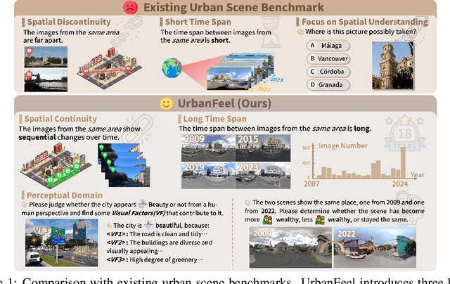
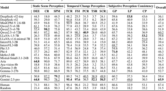
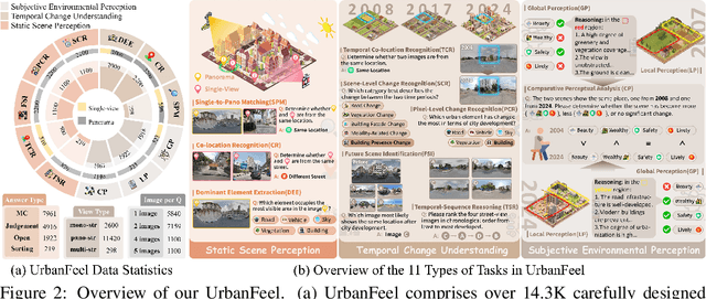
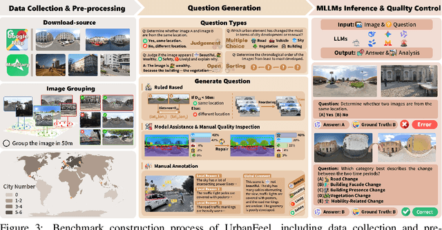
Urban development impacts over half of the global population, making human-centered understanding of its structural and perceptual changes essential for sustainable development. While Multimodal Large Language Models (MLLMs) have shown remarkable capabilities across various domains, existing benchmarks that explore their performance in urban environments remain limited, lacking systematic exploration of temporal evolution and subjective perception of urban environment that aligns with human perception. To address these limitations, we propose UrbanFeel, a comprehensive benchmark designed to evaluate the performance of MLLMs in urban development understanding and subjective environmental perception. UrbanFeel comprises 14.3K carefully constructed visual questions spanning three cognitively progressive dimensions: Static Scene Perception, Temporal Change Understanding, and Subjective Environmental Perception. We collect multi-temporal single-view and panoramic street-view images from 11 representative cities worldwide, and generate high-quality question-answer pairs through a hybrid pipeline of spatial clustering, rule-based generation, model-assisted prompting, and manual annotation. Through extensive evaluation of 20 state-of-the-art MLLMs, we observe that Gemini-2.5 Pro achieves the best overall performance, with its accuracy approaching human expert levels and narrowing the average gap to just 1.5\%. Most models perform well on tasks grounded in scene understanding. In particular, some models even surpass human annotators in pixel-level change detection. However, performance drops notably in tasks requiring temporal reasoning over urban development. Additionally, in the subjective perception dimension, several models reach human-level or even higher consistency in evaluating dimension such as beautiful and safety.
Echo-4o: Harnessing the Power of GPT-4o Synthetic Images for Improved Image Generation
Aug 13, 2025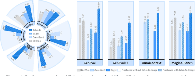
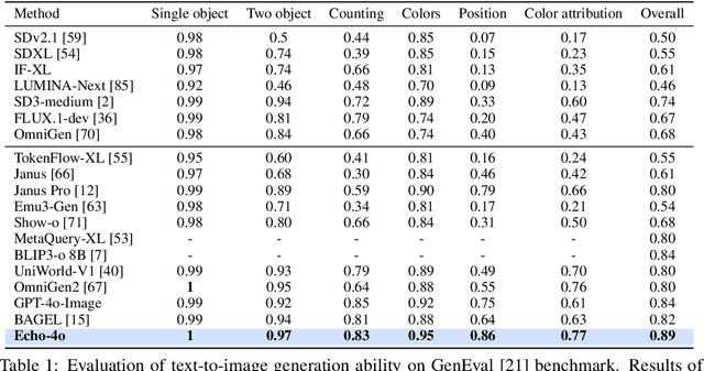
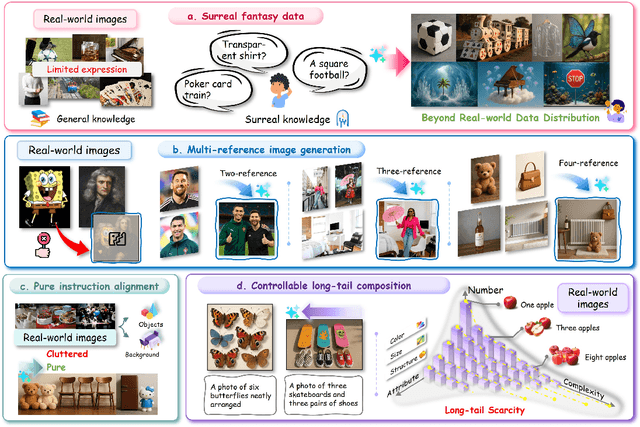
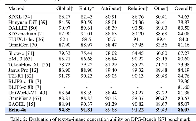
Recently, GPT-4o has garnered significant attention for its strong performance in image generation, yet open-source models still lag behind. Several studies have explored distilling image data from GPT-4o to enhance open-source models, achieving notable progress. However, a key question remains: given that real-world image datasets already constitute a natural source of high-quality data, why should we use GPT-4o-generated synthetic data? In this work, we identify two key advantages of synthetic images. First, they can complement rare scenarios in real-world datasets, such as surreal fantasy or multi-reference image generation, which frequently occur in user queries. Second, they provide clean and controllable supervision. Real-world data often contains complex background noise and inherent misalignment between text descriptions and image content, whereas synthetic images offer pure backgrounds and long-tailed supervision signals, facilitating more accurate text-to-image alignment. Building on these insights, we introduce Echo-4o-Image, a 180K-scale synthetic dataset generated by GPT-4o, harnessing the power of synthetic image data to address blind spots in real-world coverage. Using this dataset, we fine-tune the unified multimodal generation baseline Bagel to obtain Echo-4o. In addition, we propose two new evaluation benchmarks for a more accurate and challenging assessment of image generation capabilities: GenEval++, which increases instruction complexity to mitigate score saturation, and Imagine-Bench, which focuses on evaluating both the understanding and generation of imaginative content. Echo-4o demonstrates strong performance across standard benchmarks. Moreover, applying Echo-4o-Image to other foundation models (e.g., OmniGen2, BLIP3-o) yields consistent performance gains across multiple metrics, highlighting the datasets strong transferability.
OmniEarth-Bench: Towards Holistic Evaluation of Earth's Six Spheres and Cross-Spheres Interactions with Multimodal Observational Earth Data
May 29, 2025Existing benchmarks for Earth science multimodal learning exhibit critical limitations in systematic coverage of geosystem components and cross-sphere interactions, often constrained to isolated subsystems (only in Human-activities sphere or atmosphere) with limited evaluation dimensions (less than 16 tasks). To address these gaps, we introduce OmniEarth-Bench, the first comprehensive multimodal benchmark spanning all six Earth science spheres (atmosphere, lithosphere, Oceansphere, cryosphere, biosphere and Human-activities sphere) and cross-spheres with one hundred expert-curated evaluation dimensions. Leveraging observational data from satellite sensors and in-situ measurements, OmniEarth-Bench integrates 29,779 annotations across four tiers: perception, general reasoning, scientific knowledge reasoning and chain-of-thought (CoT) reasoning. This involves the efforts of 2-5 experts per sphere to establish authoritative evaluation dimensions and curate relevant observational datasets, 40 crowd-sourcing annotators to assist experts for annotations, and finally, OmniEarth-Bench is validated via hybrid expert-crowd workflows to reduce label ambiguity. Experiments on 9 state-of-the-art MLLMs reveal that even the most advanced models struggle with our benchmarks, where none of them reach 35\% accuracy. Especially, in some cross-spheres tasks, the performance of leading models like GPT-4o drops to 0.0\%. OmniEarth-Bench sets a new standard for geosystem-aware AI, advancing both scientific discovery and practical applications in environmental monitoring and disaster prediction. The dataset, source code, and trained models were released.
Shifting AI Efficiency From Model-Centric to Data-Centric Compression
May 25, 2025The rapid advancement of large language models (LLMs) and multi-modal LLMs (MLLMs) has historically relied on model-centric scaling through increasing parameter counts from millions to hundreds of billions to drive performance gains. However, as we approach hardware limits on model size, the dominant computational bottleneck has fundamentally shifted to the quadratic cost of self-attention over long token sequences, now driven by ultra-long text contexts, high-resolution images, and extended videos. In this position paper, \textbf{we argue that the focus of research for efficient AI is shifting from model-centric compression to data-centric compression}. We position token compression as the new frontier, which improves AI efficiency via reducing the number of tokens during model training or inference. Through comprehensive analysis, we first examine recent developments in long-context AI across various domains and establish a unified mathematical framework for existing model efficiency strategies, demonstrating why token compression represents a crucial paradigm shift in addressing long-context overhead. Subsequently, we systematically review the research landscape of token compression, analyzing its fundamental benefits and identifying its compelling advantages across diverse scenarios. Furthermore, we provide an in-depth analysis of current challenges in token compression research and outline promising future directions. Ultimately, our work aims to offer a fresh perspective on AI efficiency, synthesize existing research, and catalyze innovative developments to address the challenges that increasing context lengths pose to the AI community's advancement.