Rui Song
PABU: Progress-Aware Belief Update for Efficient LLM Agents
Feb 09, 2026Abstract:Large Language Model (LLM) agents commonly condition actions on full action-observation histories, which introduce task-irrelevant information that easily leads to redundant actions and higher inference cost. We propose Progress-Aware Belief Update (PABU), a belief-state framework that compactly represents an agent's state by explicitly modeling task progress and selectively retaining past actions and observations. At each step, the agent predicts its relative progress since the previous round and decides whether the newly encountered interaction should be stored, conditioning future decisions only on the retained subset. Across eight environments in the AgentGym benchmark, and using identical training trajectories, PABU achieves an 81.0% task completion rate, outperforming previous State of the art (SoTA) models with full-history belief by 23.9%. Additionally, PABU's progress-oriented action selection improves efficiency, reducing the average number of interaction steps to 9.5, corresponding to a 26.9% reduction. Ablation studies show that both explicit progress prediction and selective retention are necessary for robust belief learning and performance gains.
TIC-VLA: A Think-in-Control Vision-Language-Action Model for Robot Navigation in Dynamic Environments
Feb 02, 2026Abstract:Robots in dynamic, human-centric environments must follow language instructions while maintaining real-time reactive control. Vision-language-action (VLA) models offer a promising framework, but they assume temporally aligned reasoning and control, despite semantic inference being inherently delayed relative to real-time action. We introduce Think-in-Control (TIC)-VLA, a latency-aware framework that explicitly models delayed semantic reasoning during action generation. TIC-VLA defines a delayed semantic-control interface that conditions action generation on delayed vision-language semantic states and explicit latency metadata, in addition to current observations, enabling policies to compensate for asynchronous reasoning. We further propose a latency-consistent training pipeline that injects reasoning inference delays during imitation learning and online reinforcement learning, aligning training with asynchronous deployment. To support realistic evaluation, we present DynaNav, a physics-accurate, photo-realistic simulation suite for language-guided navigation in dynamic environments. Extensive experiments in simulation and on a real robot show that TIC-VLA consistently outperforms prior VLA models while maintaining robust real-time control under multi-second reasoning latency. Project website: https://ucla-mobility.github.io/TIC-VLA/
LiftProj: Space Lifting and Projection-Based Panorama Stitching
Dec 30, 2025Abstract:Traditional image stitching techniques have predominantly utilized two-dimensional homography transformations and mesh warping to achieve alignment on a planar surface. While effective for scenes that are approximately coplanar or exhibit minimal parallax, these approaches often result in ghosting, structural bending, and stretching distortions in non-overlapping regions when applied to real three-dimensional scenes characterized by multiple depth layers and occlusions. Such challenges are exacerbated in multi-view accumulations and 360° closed-loop stitching scenarios. In response, this study introduces a spatially lifted panoramic stitching framework that initially elevates each input image into a dense three-dimensional point representation within a unified coordinate system, facilitating global cross-view fusion augmented by confidence metrics. Subsequently, a unified projection center is established in three-dimensional space, and an equidistant cylindrical projection is employed to map the fused data onto a single panoramic manifold, thereby producing a geometrically consistent 360° panoramic layout. Finally, hole filling is conducted within the canvas domain to address unknown regions revealed by viewpoint transitions, restoring continuous texture and semantic coherence. This framework reconceptualizes stitching from a two-dimensional warping paradigm to a three-dimensional consistency paradigm and is designed to flexibly incorporate various three-dimensional lifting and completion modules. Experimental evaluations demonstrate that the proposed method substantially mitigates geometric distortions and ghosting artifacts in scenarios involving significant parallax and complex occlusions, yielding panoramic results that are more natural and consistent.
OccuFly: A 3D Vision Benchmark for Semantic Scene Completion from the Aerial Perspective
Dec 23, 2025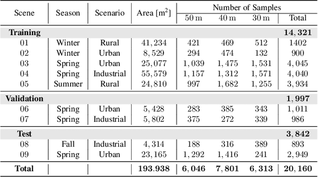

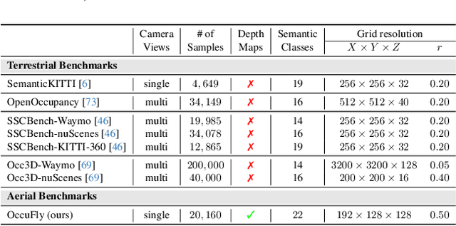

Abstract:Semantic Scene Completion (SSC) is crucial for 3D perception in mobile robotics, as it enables holistic scene understanding by jointly estimating dense volumetric occupancy and per-voxel semantics. Although SSC has been widely studied in terrestrial domains such as autonomous driving, aerial scenarios like autonomous flying remain largely unexplored, thereby limiting progress on downstream applications. Furthermore, LiDAR sensors represent the primary modality for SSC data generation, which poses challenges for most uncrewed aerial vehicles (UAVs) due to flight regulations, mass and energy constraints, and the sparsity of LiDAR-based point clouds from elevated viewpoints. To address these limitations, we introduce OccuFly, the first real-world, camera-based aerial SSC benchmark, captured at altitudes of 50m, 40m, and 30m during spring, summer, fall, and winter. OccuFly covers urban, industrial, and rural scenarios, provides 22 semantic classes, and the data format adheres to established conventions to facilitate seamless integration with existing research. Crucially, we propose a LiDAR-free data generation framework based on camera modality, which is ubiquitous on modern UAVs. By utilizing traditional 3D reconstruction, our framework automates label transfer by lifting a subset of annotated 2D masks into the reconstructed point cloud, thereby substantially minimizing manual 3D annotation effort. Finally, we benchmark the state-of-the-art on OccuFly and highlight challenges specific to elevated viewpoints, yielding a comprehensive vision benchmark for holistic aerial 3D scene understanding.
AncientBench: Towards Comprehensive Evaluation on Excavated and Transmitted Chinese Corpora
Dec 19, 2025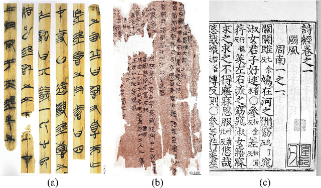


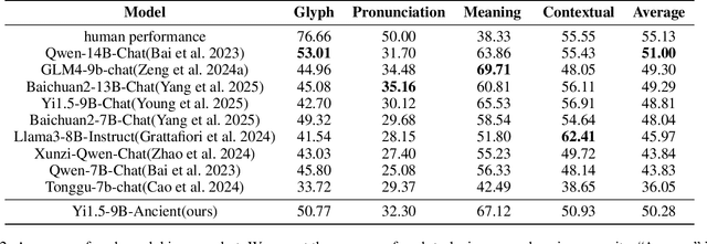
Abstract:Comprehension of ancient texts plays an important role in archaeology and understanding of Chinese history and civilization. The rapid development of large language models needs benchmarks that can evaluate their comprehension of ancient characters. Existing Chinese benchmarks are mostly targeted at modern Chinese and transmitted documents in ancient Chinese, but the part of excavated documents in ancient Chinese is not covered. To meet this need, we propose the AncientBench, which aims to evaluate the comprehension of ancient characters, especially in the scenario of excavated documents. The AncientBench is divided into four dimensions, which correspond to the four competencies of ancient character comprehension: glyph comprehension, pronunciation comprehension, meaning comprehension, and contextual comprehension. The benchmark also contains ten tasks, including radical, phonetic radical, homophone, cloze, translation, and more, providing a comprehensive framework for evaluation. We convened archaeological researchers to conduct experimental evaluations, proposed an ancient model as baseline, and conducted extensive experiments on the currently best-performing large language models. The experimental results reveal the great potential of large language models in ancient textual scenarios as well as the gap with humans. Our research aims to promote the development and application of large language models in the field of archaeology and ancient Chinese language.
SpaceDrive: Infusing Spatial Awareness into VLM-based Autonomous Driving
Dec 11, 2025Abstract:End-to-end autonomous driving methods built on vision language models (VLMs) have undergone rapid development driven by their universal visual understanding and strong reasoning capabilities obtained from the large-scale pretraining. However, we find that current VLMs struggle to understand fine-grained 3D spatial relationships which is a fundamental requirement for systems interacting with the physical world. To address this issue, we propose SpaceDrive, a spatial-aware VLM-based driving framework that treats spatial information as explicit positional encodings (PEs) instead of textual digit tokens, enabling joint reasoning over semantic and spatial representations. SpaceDrive employs a universal positional encoder to all 3D coordinates derived from multi-view depth estimation, historical ego-states, and text prompts. These 3D PEs are first superimposed to augment the corresponding 2D visual tokens. Meanwhile, they serve as a task-agnostic coordinate representation, replacing the digit-wise numerical tokens as both inputs and outputs for the VLM. This mechanism enables the model to better index specific visual semantics in spatial reasoning and directly regress trajectory coordinates rather than generating digit-by-digit, thereby enhancing planning accuracy. Extensive experiments validate that SpaceDrive achieves state-of-the-art open-loop performance on the nuScenes dataset and the second-best Driving Score of 78.02 on the Bench2Drive closed-loop benchmark over existing VLM-based methods.
MirrorMamba: Towards Scalable and Robust Mirror Detection in Videos
Nov 10, 2025Abstract:Video mirror detection has received significant research attention, yet existing methods suffer from limited performance and robustness. These approaches often over-rely on single, unreliable dynamic features, and are typically built on CNNs with limited receptive fields or Transformers with quadratic computational complexity. To address these limitations, we propose a new effective and scalable video mirror detection method, called MirrorMamba. Our approach leverages multiple cues to adapt to diverse conditions, incorporating perceived depth, correspondence and optical. We also introduce an innovative Mamba-based Multidirection Correspondence Extractor, which benefits from the global receptive field and linear complexity of the emerging Mamba spatial state model to effectively capture correspondence properties. Additionally, we design a Mamba-based layer-wise boundary enforcement decoder to resolve the unclear boundary caused by the blurred depth map. Notably, this work marks the first successful application of the Mamba-based architecture in the field of mirror detection. Extensive experiments demonstrate that our method outperforms existing state-of-the-art approaches for video mirror detection on the benchmark datasets. Furthermore, on the most challenging and representative image-based mirror detection dataset, our approach achieves state-of-the-art performance, proving its robustness and generalizability.
Efficiently Learning Synthetic Control Models for High-dimensional Disaggregated Data
Oct 26, 2025Abstract:The Synthetic Control method (SC) has become a valuable tool for estimating causal effects. Originally designed for single-treated unit scenarios, it has recently found applications in high-dimensional disaggregated settings with multiple treated units. However, challenges in practical implementation and computational efficiency arise in such scenarios. To tackle these challenges, we propose a novel approach that integrates the Multivariate Square-root Lasso method into the synthetic control framework. We rigorously establish the estimation error bounds for fitting the Synthetic Control weights using Multivariate Square-root Lasso, accommodating high-dimensionality and time series dependencies. Additionally, we quantify the estimation error for the Average Treatment Effect on the Treated (ATT). Through simulation studies, we demonstrate that our method offers superior computational efficiency without compromising estimation accuracy. We apply our method to assess the causal impact of COVID-19 Stay-at-Home Orders on the monthly unemployment rate in the United States at the county level.
Safety-Critical Learning for Long-Tail Events: The TUM Traffic Accident Dataset
Aug 20, 2025Abstract:Even though a significant amount of work has been done to increase the safety of transportation networks, accidents still occur regularly. They must be understood as an unavoidable and sporadic outcome of traffic networks. We present the TUM Traffic Accident (TUMTraf-A) dataset, a collection of real-world highway accidents. It contains ten sequences of vehicle crashes at high-speed driving with 294,924 labeled 2D and 93,012 labeled 3D boxes and track IDs within 48,144 labeled frames recorded from four roadside cameras and LiDARs at 10 Hz. The dataset contains ten object classes and is provided in the OpenLABEL format. We propose Accid3nD, an accident detection model that combines a rule-based approach with a learning-based one. Experiments and ablation studies on our dataset show the robustness of our proposed method. The dataset, model, and code are available on our project website: https://tum-traffic-dataset.github.io/tumtraf-a.
Off-Policy Evaluation Under Nonignorable Missing Data
Jul 09, 2025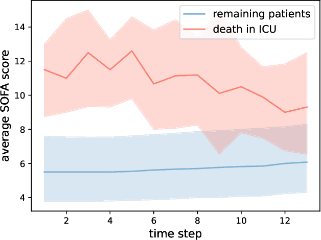
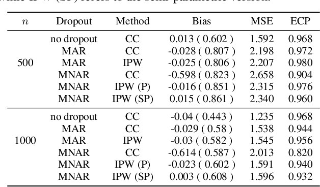
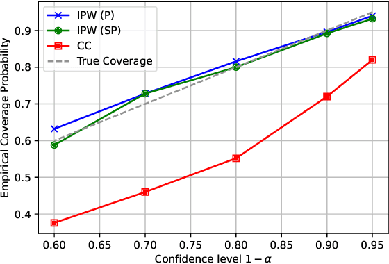
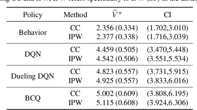
Abstract:Off-Policy Evaluation (OPE) aims to estimate the value of a target policy using offline data collected from potentially different policies. In real-world applications, however, logged data often suffers from missingness. While OPE has been extensively studied in the literature, a theoretical understanding of how missing data affects OPE results remains unclear. In this paper, we investigate OPE in the presence of monotone missingness and theoretically demonstrate that the value estimates remain unbiased under ignorable missingness but can be biased under nonignorable (informative) missingness. To retain the consistency of value estimation, we propose an inverse probability weighted value estimator and conduct statistical inference to quantify the uncertainty of the estimates. Through a series of numerical experiments, we empirically demonstrate that our proposed estimator yields a more reliable value inference under missing data.
 Add to Chrome
 Add to Firefox
 Add to Edge