Bing Zhou
Zhengzhou University
Predicting Healthcare System Visitation Flow by Integrating Hospital Attributes and Population Socioeconomics with Human Mobility Data
Jan 22, 2026Abstract:Healthcare visitation patterns are influenced by a complex interplay of hospital attributes, population socioeconomics, and spatial factors. However, existing research often adopts a fragmented approach, examining these determinants in isolation. This study addresses this gap by integrating hospital capacities, occupancy rates, reputation, and popularity with population SES and spatial mobility patterns to predict visitation flows and analyze influencing factors. Utilizing four years of SafeGraph mobility data and user experience data from Google Maps Reviews, five flow prediction models, Naive Regression, Gradient Boosting, Multilayer Perceptrons (MLPs), Deep Gravity, and Heterogeneous Graph Neural Networks (HGNN),were trained and applied to simulate visitation flows in Houston, Texas, U.S. The Shapley additive explanation (SHAP) analysis and the Partial Dependence Plot (PDP) method were employed to examine the combined impacts of different factors on visitation patterns. The findings reveal that Deep Gravity outperformed other models. Hospital capacities, ICU occupancy rates, ratings, and popularity significantly influence visitation patterns, with their effects varying across different travel distances. Short-distance visits are primarily driven by convenience, whereas long-distance visits are influenced by hospital ratings. White-majority areas exhibited lower sensitivity to hospital ratings for short-distance visits, while Asian populations and those with higher education levels prioritized hospital rating in their visitation decisions. SES further influence these patterns, as areas with higher proportions of Hispanic, Black, under-18, and over-65 populations tend to have more frequent hospital visits, potentially reflecting greater healthcare needs or limited access to alternative medical services.
Animated 3DGS Avatars in Diverse Scenes with Consistent Lighting and Shadows
Jan 04, 2026Abstract:We present a method for consistent lighting and shadows when animated 3D Gaussian Splatting (3DGS) avatars interact with 3DGS scenes or with dynamic objects inserted into otherwise static scenes. Our key contribution is Deep Gaussian Shadow Maps (DGSM), a modern analogue of the classical shadow mapping algorithm tailored to the volumetric 3DGS representation. Building on the classic deep shadow mapping idea, we show that 3DGS admits closed form light accumulation along light rays, enabling volumetric shadow computation without meshing. For each estimated light, we tabulate transmittance over concentric radial shells and store them in octahedral atlases, which modern GPUs can sample in real time per query to attenuate affected scene Gaussians and thus cast and receive shadows consistently. To relight moving avatars, we approximate the local environment illumination with HDRI probes represented in a spherical harmonic (SH) basis and apply a fast per Gaussian radiance transfer, avoiding explicit BRDF estimation or offline optimization. We demonstrate environment consistent lighting for avatars from AvatarX and ActorsHQ, composited into ScanNet++, DL3DV, and SuperSplat scenes, and show interactions with inserted objects. Across single and multi avatar settings, DGSM and SH relighting operate fully in the volumetric 3DGS representation, yielding coherent shadows and relighting while avoiding meshing.
TalkVerse: Democratizing Minute-Long Audio-Driven Video Generation
Dec 16, 2025Abstract:We introduce TalkVerse, a large-scale, open corpus for single-person, audio-driven talking video generation designed to enable fair, reproducible comparison across methods. While current state-of-the-art systems rely on closed data or compute-heavy models, TalkVerse offers 2.3 million high-resolution (720p/1080p) audio-video synchronized clips totaling 6.3k hours. These are curated from over 60k hours of video via a transparent pipeline that includes scene-cut detection, aesthetic assessment, strict audio-visual synchronization checks, and comprehensive annotations including 2D skeletons and structured visual/audio-style captions. Leveraging TalkVerse, we present a reproducible 5B DiT baseline built on Wan2.2-5B. By utilizing a video VAE with a high downsampling ratio and a sliding window mechanism with motion-frame context, our model achieves minute-long generation with low drift. It delivers comparable lip-sync and visual quality to the 14B Wan-S2V model but with 10$\times$ lower inference cost. To enhance storytelling in long videos, we integrate an MLLM director to rewrite prompts based on audio and visual cues. Furthermore, our model supports zero-shot video dubbing via controlled latent noise injection. We open-source the dataset, training recipes, and 5B checkpoints to lower barriers for research in audio-driven human video generation. Project Page: https://zhenzhiwang.github.io/talkverse/
AHA! Animating Human Avatars in Diverse Scenes with Gaussian Splatting
Nov 13, 2025Abstract:We present a novel framework for animating humans in 3D scenes using 3D Gaussian Splatting (3DGS), a neural scene representation that has recently achieved state-of-the-art photorealistic results for novel-view synthesis but remains under-explored for human-scene animation and interaction. Unlike existing animation pipelines that use meshes or point clouds as the underlying 3D representation, our approach introduces the use of 3DGS as the 3D representation to the problem of animating humans in scenes. By representing humans and scenes as Gaussians, our approach allows for geometry-consistent free-viewpoint rendering of humans interacting with 3D scenes. Our key insight is that the rendering can be decoupled from the motion synthesis and each sub-problem can be addressed independently, without the need for paired human-scene data. Central to our method is a Gaussian-aligned motion module that synthesizes motion without explicit scene geometry, using opacity-based cues and projected Gaussian structures to guide human placement and pose alignment. To ensure natural interactions, we further propose a human-scene Gaussian refinement optimization that enforces realistic contact and navigation. We evaluate our approach on scenes from Scannet++ and the SuperSplat library, and on avatars reconstructed from sparse and dense multi-view human capture. Finally, we demonstrate that our framework allows for novel applications such as geometry-consistent free-viewpoint rendering of edited monocular RGB videos with new animated humans, showcasing the unique advantage of 3DGS for monocular video-based human animation.
Ponimator: Unfolding Interactive Pose for Versatile Human-human Interaction Animation
Oct 16, 2025Abstract:Close-proximity human-human interactive poses convey rich contextual information about interaction dynamics. Given such poses, humans can intuitively infer the context and anticipate possible past and future dynamics, drawing on strong priors of human behavior. Inspired by this observation, we propose Ponimator, a simple framework anchored on proximal interactive poses for versatile interaction animation. Our training data consists of close-contact two-person poses and their surrounding temporal context from motion-capture interaction datasets. Leveraging interactive pose priors, Ponimator employs two conditional diffusion models: (1) a pose animator that uses the temporal prior to generate dynamic motion sequences from interactive poses, and (2) a pose generator that applies the spatial prior to synthesize interactive poses from a single pose, text, or both when interactive poses are unavailable. Collectively, Ponimator supports diverse tasks, including image-based interaction animation, reaction animation, and text-to-interaction synthesis, facilitating the transfer of interaction knowledge from high-quality mocap data to open-world scenarios. Empirical experiments across diverse datasets and applications demonstrate the universality of the pose prior and the effectiveness and robustness of our framework.
Two Sides of the Same Optimization Coin: Model Degradation and Representation Collapse in Graph Foundation Models
Sep 11, 2025Abstract:Graph foundation models, inspired by the success of LLMs, are designed to learn the optimal embedding from multi-domain TAGs for the downstream cross-task generalization capability. During our investigation, graph VQ-MAE stands out among the increasingly diverse landscape of GFM architectures. This is attributed to its ability to jointly encode topology and textual attributes from multiple domains into discrete embedding spaces with clear semantic boundaries. Despite its potential, domain generalization conflicts cause imperceptible pitfalls. In this paper, we instantiate two of them, and they are just like two sides of the same GFM optimization coin - Side 1 Model Degradation: The encoder and codebook fail to capture the diversity of inputs; Side 2 Representation Collapse: The hidden embedding and codebook vector fail to preserve semantic separability due to constraints from narrow representation subspaces. These two pitfalls (sides) collectively impair the decoder and generate the low-quality reconstructed supervision, causing the GFM optimization dilemma during pre-training (coin). Through empirical investigation, we attribute the above challenges to Information Bottleneck and Regularization Deficit. To address them, we propose MoT (Mixture-of-Tinkers) - (1) Information Tinker for Two Pitfalls, which utilizes an edge-wise semantic fusion strategy and a mixture-of-codebooks with domain-aware routing to improve information capacity. (2) Regularization Tinker for Optimization Coin, which utilizes two additional regularizations to further improve gradient supervision in our proposed Information Tinker. Notably, as a flexible architecture, MoT adheres to the scaling laws of GFM, offering a controllable model scale. Compared to SOTA baselines, experiments on 22 datasets across 6 domains demonstrate that MoT achieves significant improvements in supervised, few-shot, and zero-shot scenarios.
HIAL: A New Paradigm for Hypergraph Active Learning via Influence Maximization
Jul 28, 2025Abstract:In recent years, Hypergraph Neural Networks (HNNs) have demonstrated immense potential in handling complex systems with high-order interactions. However, acquiring large-scale, high-quality labeled data for these models is costly, making Active Learning (AL) a critical technique. Existing Graph Active Learning (GAL) methods, when applied to hypergraphs, often rely on techniques like "clique expansion," which destroys the high-order structural information crucial to a hypergraph's success, thereby leading to suboptimal performance. To address this challenge, we introduce HIAL (Hypergraph Active Learning), a native active learning framework designed specifically for hypergraphs. We innovatively reformulate the Hypergraph Active Learning (HAL) problem as an Influence Maximization task. The core of HIAL is a dual-perspective influence function that, based on our novel "High-Order Interaction-Aware (HOI-Aware)" propagation mechanism, synergistically evaluates a node's feature-space coverage (via Magnitude of Influence, MoI) and its topological influence (via Expected Diffusion Value, EDV). We prove that this objective function is monotone and submodular, thus enabling the use of an efficient greedy algorithm with a formal (1-1/e) approximation guarantee. Extensive experiments on seven public datasets demonstrate that HIAL significantly outperforms state-of-the-art baselines in terms of performance, efficiency, generality, and robustness, establishing an efficient and powerful new paradigm for active learning on hypergraphs.
Simultaneous Polysomnography and Cardiotocography Reveal Temporal Correlation Between Maternal Obstructive Sleep Apnea and Fetal Hypoxia
Apr 17, 2025Abstract:Background: Obstructive sleep apnea syndrome (OSAS) during pregnancy is common and can negatively affect fetal outcomes. However, studies on the immediate effects of maternal hypoxia on fetal heart rate (FHR) changes are lacking. Methods: We used time-synchronized polysomnography (PSG) and cardiotocography (CTG) data from two cohorts to analyze the correlation between maternal hypoxia and FHR changes (accelerations or decelerations). Maternal hypoxic event characteristics were analyzed using generalized linear modeling (GLM) to assess their associations with different FHR changes. Results: A total of 118 pregnant women participated. FHR changes were significantly associated with maternal hypoxia, primarily characterized by accelerations. A longer hypoxic duration correlated with more significant FHR accelerations (P < 0.05), while prolonged hypoxia and greater SpO2 drop were linked to FHR decelerations (P < 0.05). Both cohorts showed a transient increase in FHR during maternal hypoxia, which returned to baseline after the event resolved. Conclusion: Maternal hypoxia significantly affects FHR, suggesting that maternal OSAS may contribute to fetal hypoxia. These findings highlight the importance of maternal-fetal interactions and provide insights for future interventions.
Hyperlocal disaster damage assessment using bi-temporal street-view imagery and pre-trained vision models
Apr 12, 2025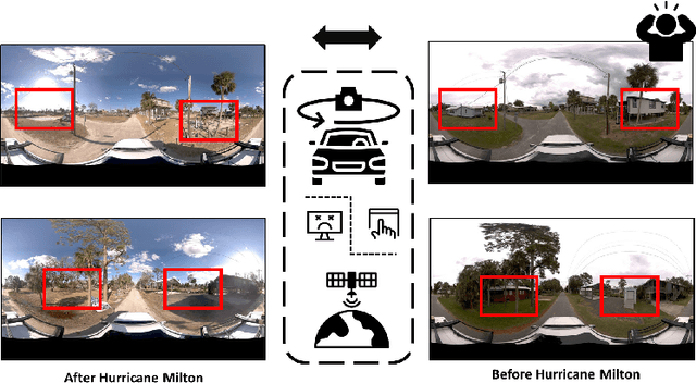
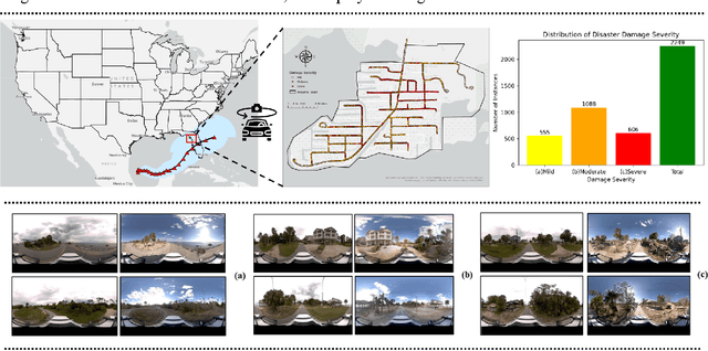
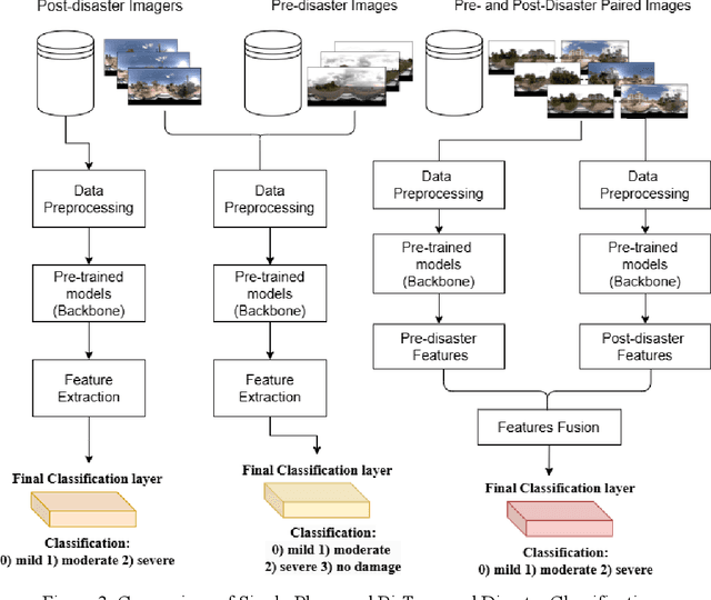

Abstract:Street-view images offer unique advantages for disaster damage estimation as they capture impacts from a visual perspective and provide detailed, on-the-ground insights. Despite several investigations attempting to analyze street-view images for damage estimation, they mainly focus on post-disaster images. The potential of time-series street-view images remains underexplored. Pre-disaster images provide valuable benchmarks for accurate damage estimations at building and street levels. These images could aid annotators in objectively labeling post-disaster impacts, improving the reliability of labeled data sets for model training, and potentially enhancing the model performance in damage evaluation. The goal of this study is to estimate hyperlocal, on-the-ground disaster damages using bi-temporal street-view images and advanced pre-trained vision models. Street-view images before and after 2024 Hurricane Milton in Horseshoe Beach, Florida, were collected for experiments. The objectives are: (1) to assess the performance gains of incorporating pre-disaster street-view images as a no-damage category in fine-tuning pre-trained models, including Swin Transformer and ConvNeXt, for damage level classification; (2) to design and evaluate a dual-channel algorithm that reads pair-wise pre- and post-disaster street-view images for hyperlocal damage assessment. The results indicate that incorporating pre-disaster street-view images and employing a dual-channel processing framework can significantly enhance damage assessment accuracy. The accuracy improves from 66.14% with the Swin Transformer baseline to 77.11% with the dual-channel Feature-Fusion ConvNeXt model. This research enables rapid, operational damage assessments at hyperlocal spatial resolutions, providing valuable insights to support effective decision-making in disaster management and resilience planning.
Toward General and Robust LLM-enhanced Text-attributed Graph Learning
Apr 03, 2025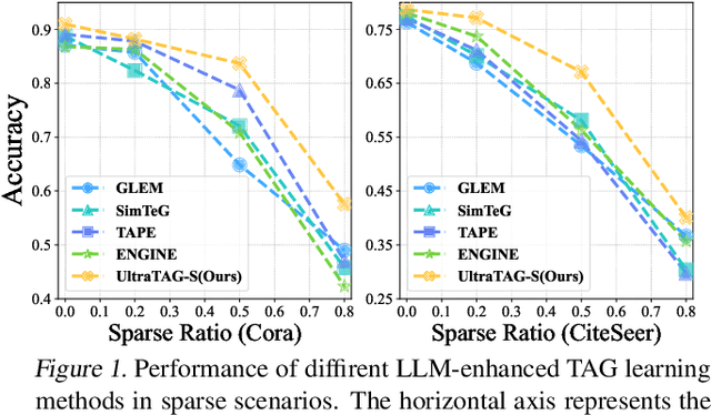

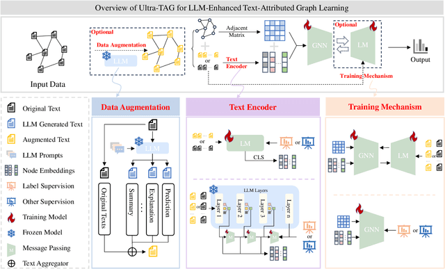

Abstract:Recent advancements in Large Language Models (LLMs) and the proliferation of Text-Attributed Graphs (TAGs) across various domains have positioned LLM-enhanced TAG learning as a critical research area. By utilizing rich graph descriptions, this paradigm leverages LLMs to generate high-quality embeddings, thereby enhancing the representational capacity of Graph Neural Networks (GNNs). However, the field faces significant challenges: (1) the absence of a unified framework to systematize the diverse optimization perspectives arising from the complex interactions between LLMs and GNNs, and (2) the lack of a robust method capable of handling real-world TAGs, which often suffer from texts and edge sparsity, leading to suboptimal performance. To address these challenges, we propose UltraTAG, a unified pipeline for LLM-enhanced TAG learning. UltraTAG provides a unified comprehensive and domain-adaptive framework that not only organizes existing methodologies but also paves the way for future advancements in the field. Building on this framework, we propose UltraTAG-S, a robust instantiation of UltraTAG designed to tackle the inherent sparsity issues in real-world TAGs. UltraTAG-S employs LLM-based text propagation and text augmentation to mitigate text sparsity, while leveraging LLM-augmented node selection techniques based on PageRank and edge reconfiguration strategies to address edge sparsity. Our extensive experiments demonstrate that UltraTAG-S significantly outperforms existing baselines, achieving improvements of 2.12\% and 17.47\% in ideal and sparse settings, respectively. Moreover, as the data sparsity ratio increases, the performance improvement of UltraTAG-S also rises, which underscores the effectiveness and robustness of UltraTAG-S.
 Add to Chrome
 Add to Firefox
 Add to Edge