 Add to Chrome
 Add to Firefox
 Add to Edge
Hyperlocal disaster damage assessment using bi-temporal street-view imagery and pre-trained vision models
Apr 12, 2025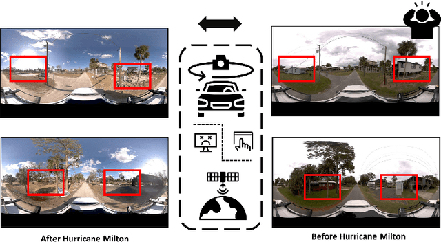
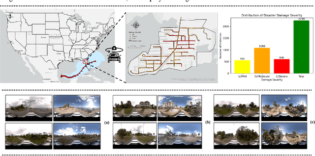
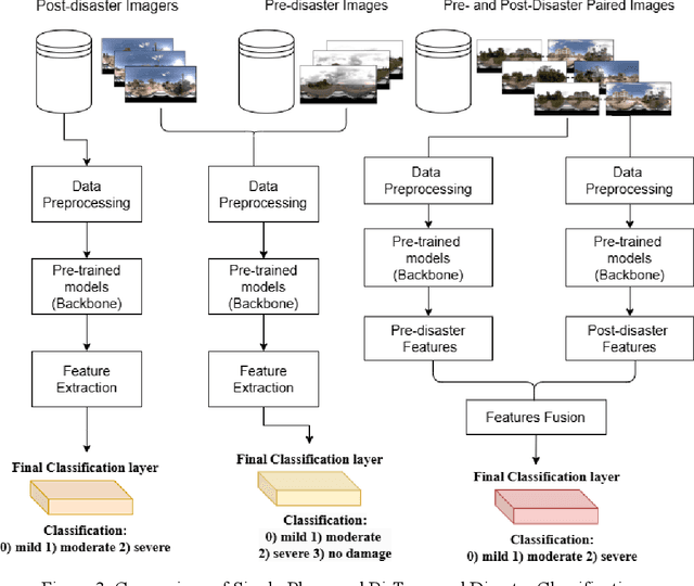
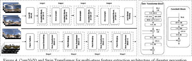
Street-view images offer unique advantages for disaster damage estimation as they capture impacts from a visual perspective and provide detailed, on-the-ground insights. Despite several investigations attempting to analyze street-view images for damage estimation, they mainly focus on post-disaster images. The potential of time-series street-view images remains underexplored. Pre-disaster images provide valuable benchmarks for accurate damage estimations at building and street levels. These images could aid annotators in objectively labeling post-disaster impacts, improving the reliability of labeled data sets for model training, and potentially enhancing the model performance in damage evaluation. The goal of this study is to estimate hyperlocal, on-the-ground disaster damages using bi-temporal street-view images and advanced pre-trained vision models. Street-view images before and after 2024 Hurricane Milton in Horseshoe Beach, Florida, were collected for experiments. The objectives are: (1) to assess the performance gains of incorporating pre-disaster street-view images as a no-damage category in fine-tuning pre-trained models, including Swin Transformer and ConvNeXt, for damage level classification; (2) to design and evaluate a dual-channel algorithm that reads pair-wise pre- and post-disaster street-view images for hyperlocal damage assessment. The results indicate that incorporating pre-disaster street-view images and employing a dual-channel processing framework can significantly enhance damage assessment accuracy. The accuracy improves from 66.14% with the Swin Transformer baseline to 77.11% with the dual-channel Feature-Fusion ConvNeXt model. This research enables rapid, operational damage assessments at hyperlocal spatial resolutions, providing valuable insights to support effective decision-making in disaster management and resilience planning.
PRIME: A CyberGIS Platform for Resilience Inference Measurement and Enhancement
Apr 15, 2024


In an era of increased climatic disasters, there is an urgent need to develop reliable frameworks and tools for evaluating and improving community resilience to climatic hazards at multiple geographical and temporal scales. Defining and quantifying resilience in the social domain is relatively subjective due to the intricate interplay of socioeconomic factors with disaster resilience. Meanwhile, there is a lack of computationally rigorous, user-friendly tools that can support customized resilience assessment considering local conditions. This study aims to address these gaps through the power of CyberGIS with three objectives: 1) To develop an empirically validated disaster resilience model - Customized Resilience Inference Measurement designed for multi-scale community resilience assessment and influential socioeconomic factors identification, 2) To implement a Platform for Resilience Inference Measurement and Enhancement module in the CyberGISX platform backed by high-performance computing, 3) To demonstrate the utility of PRIME through a representative study. CRIM generates vulnerability, adaptability, and overall resilience scores derived from empirical hazard parameters. Computationally intensive Machine Learning methods are employed to explain the intricate relationships between these scores and socioeconomic driving factors. PRIME provides a web-based notebook interface guiding users to select study areas, configure parameters, calculate and geo-visualize resilience scores, and interpret socioeconomic factors shaping resilience capacities. A representative study showcases the efficiency of the platform while explaining how the visual results obtained may be interpreted. The essence of this work lies in its comprehensive architecture that encapsulates the requisite data, analytical and geo-visualization functions, and ML models for resilience assessment.