Benjamin Caine
PseudoAugment: Learning to Use Unlabeled Data for Data Augmentation in Point Clouds
Oct 24, 2022Abstract:Data augmentation is an important technique to improve data efficiency and save labeling cost for 3D detection in point clouds. Yet, existing augmentation policies have so far been designed to only utilize labeled data, which limits the data diversity. In this paper, we recognize that pseudo labeling and data augmentation are complementary, thus propose to leverage unlabeled data for data augmentation to enrich the training data. In particular, we design three novel pseudo-label based data augmentation policies (PseudoAugments) to fuse both labeled and pseudo-labeled scenes, including frames (PseudoFrame), objecta (PseudoBBox), and background (PseudoBackground). PseudoAugments outperforms pseudo labeling by mitigating pseudo labeling errors and generating diverse fused training scenes. We demonstrate PseudoAugments generalize across point-based and voxel-based architectures, different model capacity and both KITTI and Waymo Open Dataset. To alleviate the cost of hyperparameter tuning and iterative pseudo labeling, we develop a population-based data augmentation framework for 3D detection, named AutoPseudoAugment. Unlike previous works that perform pseudo-labeling offline, our framework performs PseudoAugments and hyperparameter tuning in one shot to reduce computational cost. Experimental results on the large-scale Waymo Open Dataset show our method outperforms state-of-the-art auto data augmentation method (PPBA) and self-training method (pseudo labeling). In particular, AutoPseudoAugment is about 3X and 2X data efficient on vehicle and pedestrian tasks compared to prior arts. Notably, AutoPseudoAugment nearly matches the full dataset training results, with just 10% of the labeled run segments on the vehicle detection task.
When does dough become a bagel? Analyzing the remaining mistakes on ImageNet
May 09, 2022


Abstract:Image classification accuracy on the ImageNet dataset has been a barometer for progress in computer vision over the last decade. Several recent papers have questioned the degree to which the benchmark remains useful to the community, yet innovations continue to contribute gains to performance, with today's largest models achieving 90%+ top-1 accuracy. To help contextualize progress on ImageNet and provide a more meaningful evaluation for today's state-of-the-art models, we manually review and categorize every remaining mistake that a few top models make in order to provide insight into the long-tail of errors on one of the most benchmarked datasets in computer vision. We focus on the multi-label subset evaluation of ImageNet, where today's best models achieve upwards of 97% top-1 accuracy. Our analysis reveals that nearly half of the supposed mistakes are not mistakes at all, and we uncover new valid multi-labels, demonstrating that, without careful review, we are significantly underestimating the performance of these models. On the other hand, we also find that today's best models still make a significant number of mistakes (40%) that are obviously wrong to human reviewers. To calibrate future progress on ImageNet, we provide an updated multi-label evaluation set, and we curate ImageNet-Major: a 68-example "major error" slice of the obvious mistakes made by today's top models -- a slice where models should achieve near perfection, but today are far from doing so.
To the Point: Efficient 3D Object Detection in the Range Image with Graph Convolution Kernels
Jun 25, 2021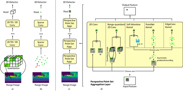
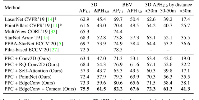
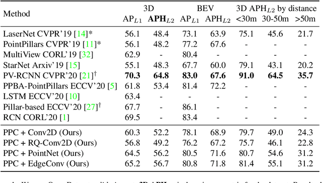
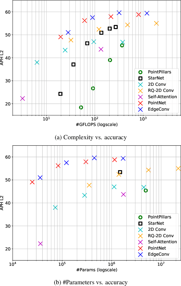
Abstract:3D object detection is vital for many robotics applications. For tasks where a 2D perspective range image exists, we propose to learn a 3D representation directly from this range image view. To this end, we designed a 2D convolutional network architecture that carries the 3D spherical coordinates of each pixel throughout the network. Its layers can consume any arbitrary convolution kernel in place of the default inner product kernel and exploit the underlying local geometry around each pixel. We outline four such kernels: a dense kernel according to the bag-of-words paradigm, and three graph kernels inspired by recent graph neural network advances: the Transformer, the PointNet, and the Edge Convolution. We also explore cross-modality fusion with the camera image, facilitated by operating in the perspective range image view. Our method performs competitively on the Waymo Open Dataset and improves the state-of-the-art AP for pedestrian detection from 69.7% to 75.5%. It is also efficient in that our smallest model, which still outperforms the popular PointPillars in quality, requires 180 times fewer FLOPS and model parameters
Scene Transformer: A unified multi-task model for behavior prediction and planning
Jun 15, 2021
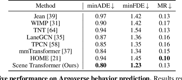
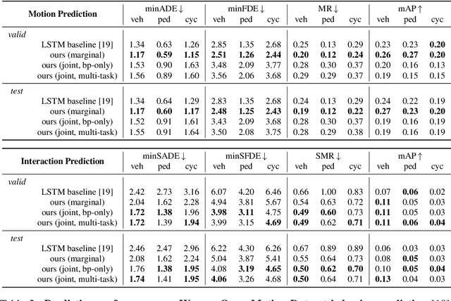

Abstract:Predicting the future motion of multiple agents is necessary for planning in dynamic environments. This task is challenging for autonomous driving since agents (e.g., vehicles and pedestrians) and their associated behaviors may be diverse and influence each other. Most prior work has focused on first predicting independent futures for each agent based on all past motion, and then planning against these independent predictions. However, planning against fixed predictions can suffer from the inability to represent the future interaction possibilities between different agents, leading to sub-optimal planning. In this work, we formulate a model for predicting the behavior of all agents jointly in real-world driving environments in a unified manner. Inspired by recent language modeling approaches, we use a masking strategy as the query to our model, enabling one to invoke a single model to predict agent behavior in many ways, such as potentially conditioned on the goal or full future trajectory of the autonomous vehicle or the behavior of other agents in the environment. Our model architecture fuses heterogeneous world state in a unified Transformer architecture by employing attention across road elements, agent interactions and time steps. We evaluate our approach on autonomous driving datasets for behavior prediction, and achieve state-of-the-art performance. Our work demonstrates that formulating the problem of behavior prediction in a unified architecture with a masking strategy may allow us to have a single model that can perform multiple motion prediction and planning related tasks effectively.
Large Scale Interactive Motion Forecasting for Autonomous Driving : The Waymo Open Motion Dataset
Apr 20, 2021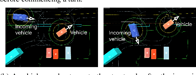
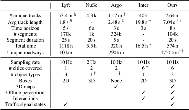
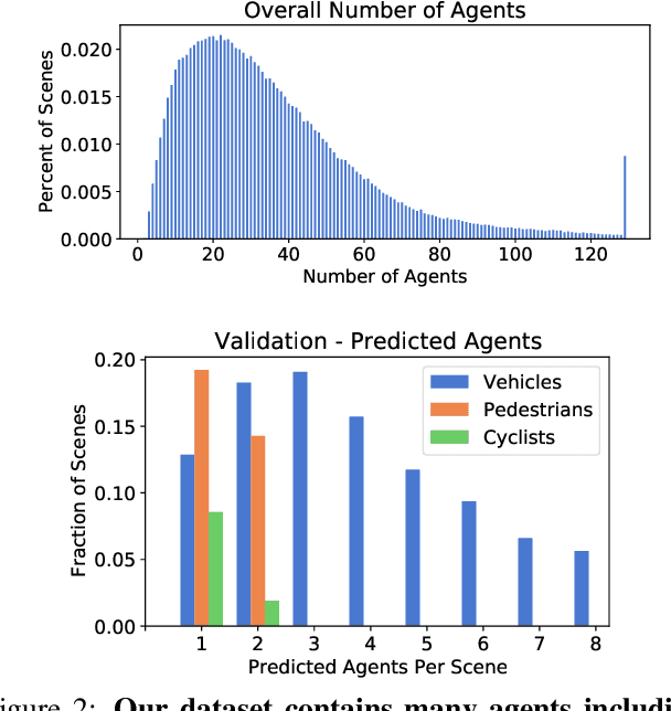

Abstract:As autonomous driving systems mature, motion forecasting has received increasing attention as a critical requirement for planning. Of particular importance are interactive situations such as merges, unprotected turns, etc., where predicting individual object motion is not sufficient. Joint predictions of multiple objects are required for effective route planning. There has been a critical need for high-quality motion data that is rich in both interactions and annotation to develop motion planning models. In this work, we introduce the most diverse interactive motion dataset to our knowledge, and provide specific labels for interacting objects suitable for developing joint prediction models. With over 100,000 scenes, each 20 seconds long at 10 Hz, our new dataset contains more than 570 hours of unique data over 1750 km of roadways. It was collected by mining for interesting interactions between vehicles, pedestrians, and cyclists across six cities within the United States. We use a high-accuracy 3D auto-labeling system to generate high quality 3D bounding boxes for each road agent, and provide corresponding high definition 3D maps for each scene. Furthermore, we introduce a new set of metrics that provides a comprehensive evaluation of both single agent and joint agent interaction motion forecasting models. Finally, we provide strong baseline models for individual-agent prediction and joint-prediction. We hope that this new large-scale interactive motion dataset will provide new opportunities for advancing motion forecasting models.
Pseudo-labeling for Scalable 3D Object Detection
Mar 02, 2021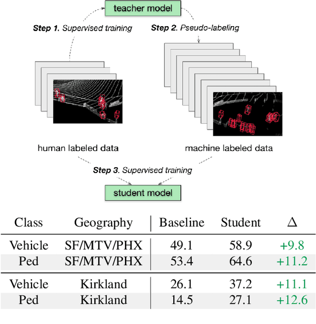
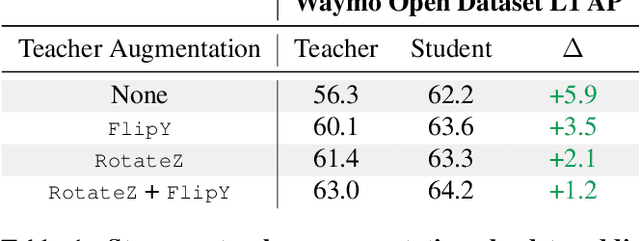
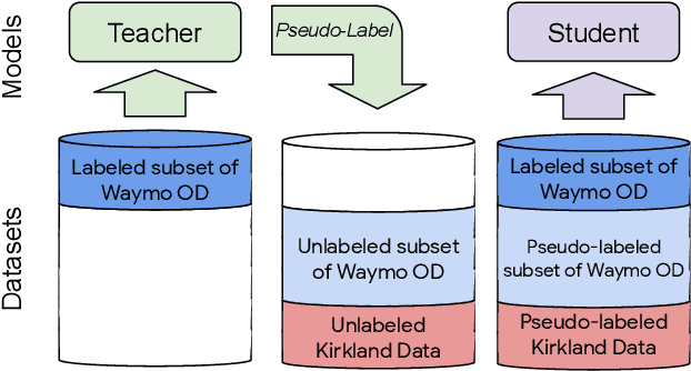
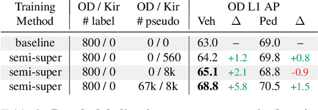
Abstract:To safely deploy autonomous vehicles, onboard perception systems must work reliably at high accuracy across a diverse set of environments and geographies. One of the most common techniques to improve the efficacy of such systems in new domains involves collecting large labeled datasets, but such datasets can be extremely costly to obtain, especially if each new deployment geography requires additional data with expensive 3D bounding box annotations. We demonstrate that pseudo-labeling for 3D object detection is an effective way to exploit less expensive and more widely available unlabeled data, and can lead to performance gains across various architectures, data augmentation strategies, and sizes of the labeled dataset. Overall, we show that better teacher models lead to better student models, and that we can distill expensive teachers into efficient, simple students. Specifically, we demonstrate that pseudo-label-trained student models can outperform supervised models trained on 3-10 times the amount of labeled examples. Using PointPillars [24], a two-year-old architecture, as our student model, we are able to achieve state of the art accuracy simply by leveraging large quantities of pseudo-labeled data. Lastly, we show that these student models generalize better than supervised models to a new domain in which we only have unlabeled data, making pseudo-label training an effective form of unsupervised domain adaptation.
Streaming Object Detection for 3-D Point Clouds
May 04, 2020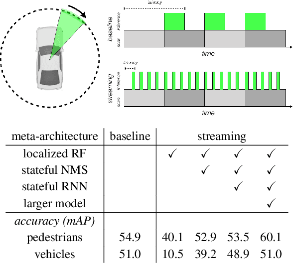
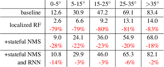
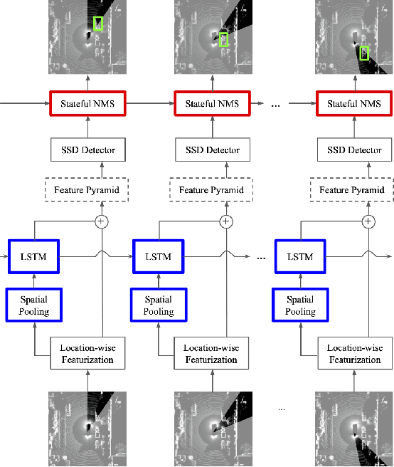
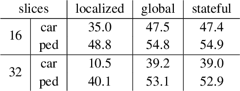
Abstract:Autonomous vehicles operate in a dynamic environment, where the speed with which a vehicle can perceive and react impacts the safety and efficacy of the system. LiDAR provides a prominent sensory modality that informs many existing perceptual systems including object detection, segmentation, motion estimation, and action recognition. The latency for perceptual systems based on point cloud data can be dominated by the amount of time for a complete rotational scan (e.g. 100 ms). This built-in data capture latency is artificial, and based on treating the point cloud as a camera image in order to leverage camera-inspired architectures. However, unlike camera sensors, most LiDAR point cloud data is natively a streaming data source in which laser reflections are sequentially recorded based on the precession of the laser beam. In this work, we explore how to build an object detector that removes this artificial latency constraint, and instead operates on native streaming data in order to significantly reduce latency. This approach has the added benefit of reducing the peak computational burden on inference hardware by spreading the computation over the acquisition time for a scan. We demonstrate a family of streaming detection systems based on sequential modeling through a series of modifications to the traditional detection meta-architecture. We highlight how this model may achieve competitive if not superior predictive performance with state-of-the-art, traditional non-streaming detection systems while achieving significant latency gains (e.g. 1/15'th - 1/3'rd of peak latency). Our results show that operating on LiDAR data in its native streaming formulation offers several advantages for self driving object detection -- advantages that we hope will be useful for any LiDAR perception system where minimizing latency is critical for safe and efficient operation.
Improving 3D Object Detection through Progressive Population Based Augmentation
Apr 02, 2020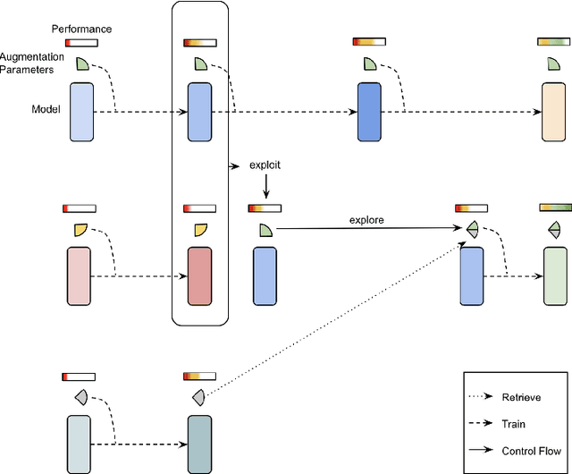

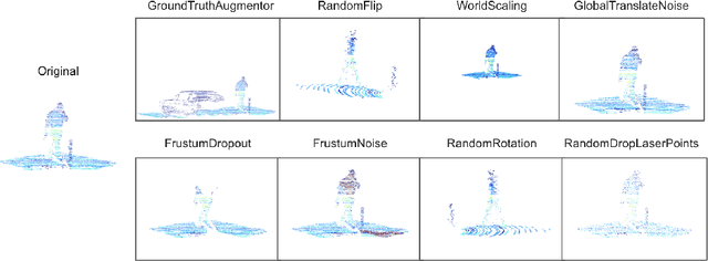

Abstract:Data augmentation has been widely adopted for object detection in 3D point clouds. All previous efforts have focused on manually designing specific data augmentation methods for individual architectures, however no work has attempted to automate the design of data augmentation in 3D detection problems -- as is common in 2D image-based computer vision. In this work, we present the first attempt to automate the design of data augmentation policies for 3D object detection. We present an algorithm, termed Progressive Population Based Augmentation (PPBA). PPBA learns to optimize augmentation strategies by narrowing down the search space and adopting the best parameters discovered in previous iterations. On the KITTI test set, PPBA improves the StarNet detector by substantial margins on the moderate difficulty category of cars, pedestrians, and cyclists, outperforming all current state-of-the-art single-stage detection models. Additional experiments on the Waymo Open Dataset indicate that PPBA continues to effectively improve 3D object detection on a 20x larger dataset compared to KITTI. The magnitude of the improvements may be comparable to advances in 3D perception architectures and the gains come without an incurred cost at inference time. In subsequent experiments, we find that PPBA may be up to 10x more data efficient than baseline 3D detection models without augmentation, highlighting that 3D detection models may achieve competitive accuracy with far fewer labeled examples.
Scalability in Perception for Autonomous Driving: Waymo Open Dataset
Dec 18, 2019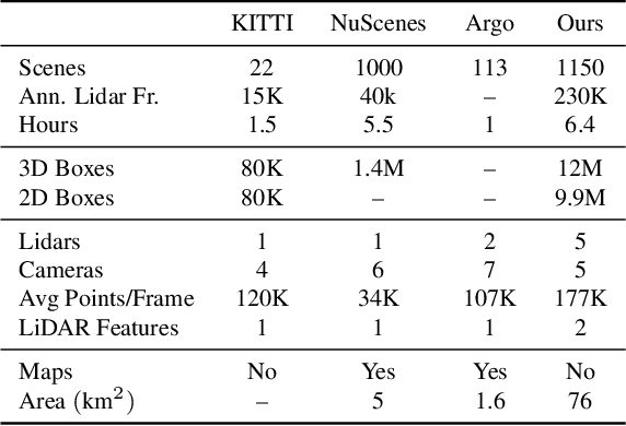


Abstract:The research community has increasing interest in autonomous driving research, despite the resource intensity of obtaining representative real world data. Existing self-driving datasets are limited in the scale and variation of the environments they capture, even though generalization within and between operating regions is crucial to the overall viability of the technology. In an effort to help align the research community's contributions with real-world self-driving problems, we introduce a new large scale, high quality, diverse dataset. Our new dataset consists of 1150 scenes that each span 20 seconds, consisting of well synchronized and calibrated high quality LiDAR and camera data captured across a range of urban and suburban geographies. It is 15x more diverse than the largest camera+LiDAR dataset available based on our proposed diversity metric. We exhaustively annotated this data with 2D (camera image) and 3D (LiDAR) bounding boxes, with consistent identifiers across frames. Finally, we provide strong baselines for 2D as well as 3D detection and tracking tasks. We further study the effects of dataset size and generalization across geographies on 3D detection methods. Find data, code and more up-to-date information at http://www.waymo.com/open.
StarNet: Targeted Computation for Object Detection in Point Clouds
Aug 29, 2019

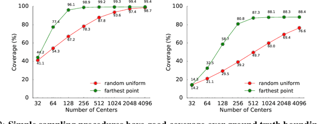

Abstract:LiDAR sensor systems provide high resolution spatial information about the environment for self-driving cars. Therefore, detecting objects from point clouds derived from LiDAR represents a critical problem. Previous work on object detection from LiDAR has emphasized re-purposing convolutional approaches from traditional camera imagery. In this work, we present an object detection system designed specifically for point cloud data blending aspects of one-stage and two-stage systems. We observe that objects in point clouds are quite distinct from traditional camera images: objects are sparse and vary widely in location, but do not exhibit scale distortions observed in single camera perspective. These two observations suggest that simple and cheap data-driven object proposals to maximize spatial coverage or match the observed densities of point cloud data may suffice. This recognition paired with a local, non-convolutional, point-based network permits building an object detector for point clouds that may be trained only once, but adapted to different computational settings -- targeted to different predictive priorities or spatial regions. We demonstrate this flexibility and the targeted detection strategies on both the KITTI detection dataset as well as on the large-scale Waymo Open Dataset. Furthermore, we find that a single network is competitive with other point cloud detectors across a range of computational budgets, while being more flexible to adapt to contextual priorities.
 Add to Chrome
 Add to Firefox
 Add to Edge