Maurice Fallon
TreeLoc: 6-DoF LiDAR Global Localization in Forests via Inter-Tree Geometric Matching
Feb 03, 2026Abstract:Reliable localization is crucial for navigation in forests, where GPS is often degraded and LiDAR measurements are repetitive, occluded, and structurally complex. These conditions weaken the assumptions of traditional urban-centric localization methods, which assume that consistent features arise from unique structural patterns, necessitating forest-centric solutions to achieve robustness in these environments. To address these challenges, we propose TreeLoc, a LiDAR-based global localization framework for forests that handles place recognition and 6-DoF pose estimation. We represent scenes using tree stems and their Diameter at Breast Height (DBH), which are aligned to a common reference frame via their axes and summarized using the tree distribution histogram (TDH) for coarse matching, followed by fine matching with a 2D triangle descriptor. Finally, pose estimation is achieved through a two-step geometric verification. On diverse forest benchmarks, TreeLoc outperforms baselines, achieving precise localization. Ablation studies validate the contribution of each component. We also propose applications for long-term forest management using descriptors from a compact global tree database. TreeLoc is open-sourced for the robotics community at https://github.com/minwoo0611/TreeLoc.
Seeing in the Dark: Benchmarking Egocentric 3D Vision with the Oxford Day-and-Night Dataset
Jun 04, 2025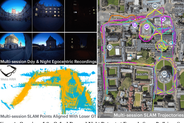
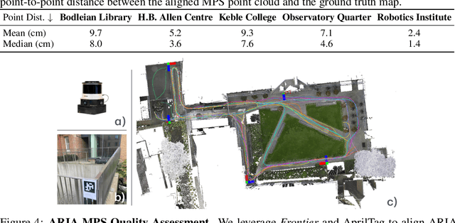

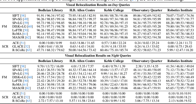
Abstract:We introduce Oxford Day-and-Night, a large-scale, egocentric dataset for novel view synthesis (NVS) and visual relocalisation under challenging lighting conditions. Existing datasets often lack crucial combinations of features such as ground-truth 3D geometry, wide-ranging lighting variation, and full 6DoF motion. Oxford Day-and-Night addresses these gaps by leveraging Meta ARIA glasses to capture egocentric video and applying multi-session SLAM to estimate camera poses, reconstruct 3D point clouds, and align sequences captured under varying lighting conditions, including both day and night. The dataset spans over 30 $\mathrm{km}$ of recorded trajectories and covers an area of 40,000 $\mathrm{m}^2$, offering a rich foundation for egocentric 3D vision research. It supports two core benchmarks, NVS and relocalisation, providing a unique platform for evaluating models in realistic and diverse environments.
ImLPR: Image-based LiDAR Place Recognition using Vision Foundation Models
May 23, 2025Abstract:LiDAR Place Recognition (LPR) is a key component in robotic localization, enabling robots to align current scans with prior maps of their environment. While Visual Place Recognition (VPR) has embraced Vision Foundation Models (VFMs) to enhance descriptor robustness, LPR has relied on task-specific models with limited use of pre-trained foundation-level knowledge. This is due to the lack of 3D foundation models and the challenges of using VFM with LiDAR point clouds. To tackle this, we introduce ImLPR, a novel pipeline that employs a pre-trained DINOv2 VFM to generate rich descriptors for LPR. To our knowledge, ImLPR is the first method to leverage a VFM to support LPR. ImLPR converts raw point clouds into Range Image Views (RIV) to leverage VFM in the LiDAR domain. It employs MultiConv adapters and Patch-InfoNCE loss for effective feature learning. We validate ImLPR using public datasets where it outperforms state-of-the-art (SOTA) methods in intra-session and inter-session LPR with top Recall@1 and F1 scores across various LiDARs. We also demonstrate that RIV outperforms Bird's-Eye-View (BEV) as a representation choice for adapting LiDAR for VFM. We release ImLPR as open source for the robotics community.
Boxi: Design Decisions in the Context of Algorithmic Performance for Robotics
Apr 25, 2025Abstract:Achieving robust autonomy in mobile robots operating in complex and unstructured environments requires a multimodal sensor suite capable of capturing diverse and complementary information. However, designing such a sensor suite involves multiple critical design decisions, such as sensor selection, component placement, thermal and power limitations, compute requirements, networking, synchronization, and calibration. While the importance of these key aspects is widely recognized, they are often overlooked in academia or retained as proprietary knowledge within large corporations. To improve this situation, we present Boxi, a tightly integrated sensor payload that enables robust autonomy of robots in the wild. This paper discusses the impact of payload design decisions made to optimize algorithmic performance for downstream tasks, specifically focusing on state estimation and mapping. Boxi is equipped with a variety of sensors: two LiDARs, 10 RGB cameras including high-dynamic range, global shutter, and rolling shutter models, an RGB-D camera, 7 inertial measurement units (IMUs) of varying precision, and a dual antenna RTK GNSS system. Our analysis shows that time synchronization, calibration, and sensor modality have a crucial impact on the state estimation performance. We frame this analysis in the context of cost considerations and environment-specific challenges. We also present a mobile sensor suite `cookbook` to serve as a comprehensive guideline, highlighting generalizable key design considerations and lessons learned during the development of Boxi. Finally, we demonstrate the versatility of Boxi being used in a variety of applications in real-world scenarios, contributing to robust autonomy. More details and code: https://github.com/leggedrobotics/grand_tour_box
OpenLex3D: A New Evaluation Benchmark for Open-Vocabulary 3D Scene Representations
Mar 25, 2025


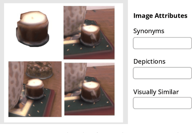
Abstract:3D scene understanding has been transformed by open-vocabulary language models that enable interaction via natural language. However, the evaluation of these representations is limited to closed-set semantics that do not capture the richness of language. This work presents OpenLex3D, a dedicated benchmark to evaluate 3D open-vocabulary scene representations. OpenLex3D provides entirely new label annotations for 23 scenes from Replica, ScanNet++, and HM3D, which capture real-world linguistic variability by introducing synonymical object categories and additional nuanced descriptions. By introducing an open-set 3D semantic segmentation task and an object retrieval task, we provide insights on feature precision, segmentation, and downstream capabilities. We evaluate various existing 3D open-vocabulary methods on OpenLex3D, showcasing failure cases, and avenues for improvement. The benchmark is publicly available at: https://openlex3d.github.io/.
SiLVR: Scalable Lidar-Visual Radiance Field Reconstruction with Uncertainty Quantification
Feb 04, 2025


Abstract:We present a neural radiance field (NeRF) based large-scale reconstruction system that fuses lidar and vision data to generate high-quality reconstructions that are geometrically accurate and capture photorealistic texture. Our system adopts the state-of-the-art NeRF representation to additionally incorporate lidar. Adding lidar data adds strong geometric constraints on the depth and surface normals, which is particularly useful when modelling uniform texture surfaces which contain ambiguous visual reconstruction cues. Furthermore, we estimate the epistemic uncertainty of the reconstruction as the spatial variance of each point location in the radiance field given the sensor observations from camera and lidar. This enables the identification of areas that are reliably reconstructed by each sensor modality, allowing the map to be filtered according to the estimated uncertainty. Our system can also exploit the trajectory produced by a real-time pose-graph lidar SLAM system during online mapping to bootstrap a (post-processed) Structure-from-Motion (SfM) reconstruction procedure reducing SfM training time by up to 70%. It also helps to properly constrain the overall metric scale which is essential for the lidar depth loss. The globally-consistent trajectory can then be divided into submaps using Spectral Clustering to group sets of co-visible images together. This submapping approach is more suitable for visual reconstruction than distance-based partitioning. Each submap is filtered according to point-wise uncertainty estimates and merged to obtain the final large-scale 3D reconstruction. We demonstrate the reconstruction system using a multi-camera, lidar sensor suite in experiments involving both robot-mounted and handheld scanning. Our test datasets cover a total area of more than 20,000 square metres, including multiple university buildings and an aerial survey of a multi-storey.
The Bare Necessities: Designing Simple, Effective Open-Vocabulary Scene Graphs
Dec 02, 2024Abstract:3D open-vocabulary scene graph methods are a promising map representation for embodied agents, however many current approaches are computationally expensive. In this paper, we reexamine the critical design choices established in previous works to optimize both efficiency and performance. We propose a general scene graph framework and conduct three studies that focus on image pre-processing, feature fusion, and feature selection. Our findings reveal that commonly used image pre-processing techniques provide minimal performance improvement while tripling computation (on a per object view basis). We also show that averaging feature labels across different views significantly degrades performance. We study alternative feature selection strategies that enhance performance without adding unnecessary computational costs. Based on our findings, we introduce a computationally balanced approach for 3D point cloud segmentation with per-object features. The approach matches state-of-the-art classification accuracy while achieving a threefold reduction in computation.
The Oxford Spires Dataset: Benchmarking Large-Scale LiDAR-Visual Localisation, Reconstruction and Radiance Field Methods
Nov 15, 2024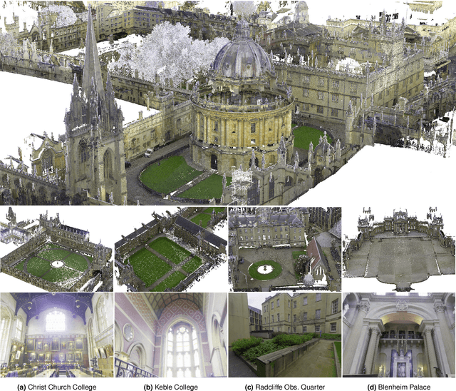
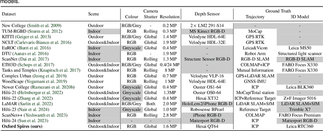
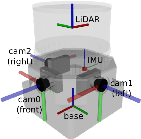
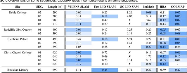
Abstract:This paper introduces a large-scale multi-modal dataset captured in and around well-known landmarks in Oxford using a custom-built multi-sensor perception unit as well as a millimetre-accurate map from a Terrestrial LiDAR Scanner (TLS). The perception unit includes three synchronised global shutter colour cameras, an automotive 3D LiDAR scanner, and an inertial sensor - all precisely calibrated. We also establish benchmarks for tasks involving localisation, reconstruction, and novel-view synthesis, which enable the evaluation of Simultaneous Localisation and Mapping (SLAM) methods, Structure-from-Motion (SfM) and Multi-view Stereo (MVS) methods as well as radiance field methods such as Neural Radiance Fields (NeRF) and 3D Gaussian Splatting. To evaluate 3D reconstruction the TLS 3D models are used as ground truth. Localisation ground truth is computed by registering the mobile LiDAR scans to the TLS 3D models. Radiance field methods are evaluated not only with poses sampled from the input trajectory, but also from viewpoints that are from trajectories which are distant from the training poses. Our evaluation demonstrates a key limitation of state-of-the-art radiance field methods: we show that they tend to overfit to the training poses/images and do not generalise well to out-of-sequence poses. They also underperform in 3D reconstruction compared to MVS systems using the same visual inputs. Our dataset and benchmarks are intended to facilitate better integration of radiance field methods and SLAM systems. The raw and processed data, along with software for parsing and evaluation, can be accessed at https://dynamic.robots.ox.ac.uk/datasets/oxford-spires/.
Markerless Aerial-Terrestrial Co-Registration of Forest Point Clouds using a Deformable Pose Graph
Oct 13, 2024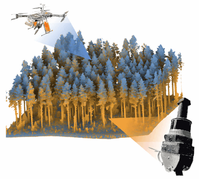
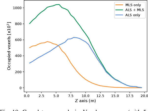
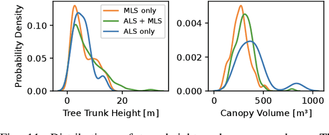
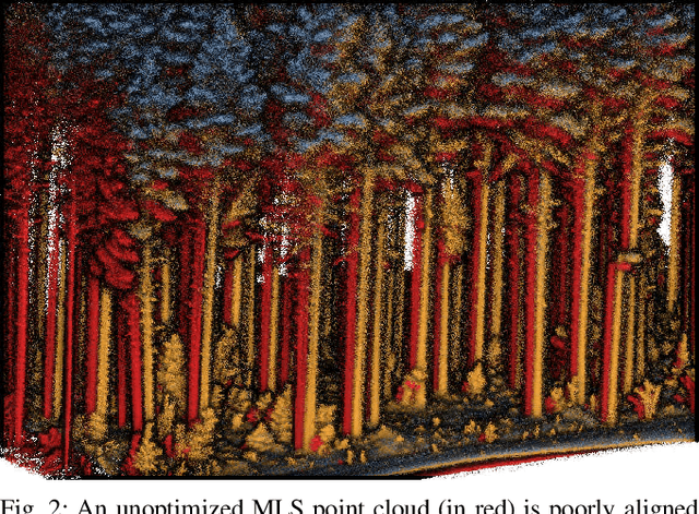
Abstract:For biodiversity and forestry applications, end-users desire maps of forests that are fully detailed, from the forest floor to the canopy. Terrestrial laser scanning and aerial laser scanning are accurate and increasingly mature methods for scanning the forest. However, individually they are not able to estimate attributes such as tree height, trunk diameter and canopy density due to the inherent differences in their field-of-view and mapping processes. In this work, we present a pipeline that can automatically generate a single joint terrestrial and aerial forest reconstruction. The novelty of the approach is a marker-free registration pipeline, which estimates a set of relative transformation constraints between the aerial cloud and terrestrial sub-clouds without requiring any co-registration reflective markers to be physically placed in the scene. Our method then uses these constraints in a pose graph formulation, which enables us to finely align the respective clouds while respecting spatial constraints introduced by the terrestrial SLAM scanning process. We demonstrate that our approach can produce a fine-grained and complete reconstruction of large-scale natural environments, enabling multi-platform data capture for forestry applications without requiring external infrastructure.
Visual Localization in 3D Maps: Comparing Point Cloud, Mesh, and NeRF Representations
Aug 21, 2024


Abstract:This paper introduces and assesses a cross-modal global visual localization system that can localize camera images within a color 3D map representation built using both visual and lidar sensing. We present three different state-of-the-art methods for creating the color 3D maps: point clouds, meshes, and neural radiance fields (NeRF). Our system constructs a database of synthetic RGB and depth image pairs from these representations. This database serves as the basis for global localization. We present an automatic approach that builds this database by synthesizing novel images of the scene and exploiting the 3D structure encoded in the different representations. Next, we present a global localization system that relies on the synthetic image database to accurately estimate the 6 DoF camera poses of monocular query images. Our localization approach relies on different learning-based global descriptors and feature detectors which enable robust image retrieval and matching despite the domain gap between (real) query camera images and the synthetic database images. We assess the system's performance through extensive real-world experiments in both indoor and outdoor settings, in order to evaluate the effectiveness of each map representation and the benefits against traditional structure-from-motion localization approaches. Our results show that all three map representations can achieve consistent localization success rates of 55% and higher across various environments. NeRF synthesized images show superior performance, localizing query images at an average success rate of 72%. Furthermore, we demonstrate that our synthesized database enables global localization even when the map creation data and the localization sequence are captured when travelling in opposite directions. Our system, operating in real-time on a mobile laptop equipped with a GPU, achieves a processing rate of 1Hz.
 Add to Chrome
 Add to Firefox
 Add to Edge