Ziyuan Liu
RecipeMasterLLM: Revisiting RoboEarth in the Era of Large Language Models
Dec 19, 2025Abstract:RoboEarth was a pioneering initiative in cloud robotics, establishing a foundational framework for robots to share and exchange knowledge about actions, objects, and environments through a standardized knowledge graph. Initially, this knowledge was predominantly hand-crafted by engineers using RDF triples within OWL Ontologies, with updates, such as changes in an object's pose, being asserted by the robot's control and perception routines. However, with the advent and rapid development of Large Language Models (LLMs), we believe that the process of knowledge acquisition can be significantly automated. To this end, we propose RecipeMasterLLM, a high-level planner, that generates OWL action ontologies based on a standardized knowledge graph in response to user prompts. This architecture leverages a fine-tuned LLM specifically trained to understand and produce action descriptions consistent with the RoboEarth standardized knowledge graph. Moreover, during the Retrieval-Augmented Generation (RAG) phase, environmental knowledge is supplied to the LLM to enhance its contextual understanding and improve the accuracy of the generated action descriptions.
CoVAR: Co-generation of Video and Action for Robotic Manipulation via Multi-Modal Diffusion
Dec 17, 2025Abstract:We present a method to generate video-action pairs that follow text instructions, starting from an initial image observation and the robot's joint states. Our approach automatically provides action labels for video diffusion models, overcoming the common lack of action annotations and enabling their full use for robotic policy learning. Existing methods either adopt two-stage pipelines, which limit tightly coupled cross-modal information sharing, or rely on adapting a single-modal diffusion model for a joint distribution that cannot fully leverage pretrained video knowledge. To overcome these limitations, we (1) extend a pretrained video diffusion model with a parallel, dedicated action diffusion model that preserves pretrained knowledge, (2) introduce a Bridge Attention mechanism to enable effective cross-modal interaction, and (3) design an action refinement module to convert coarse actions into precise controls for low-resolution datasets. Extensive evaluations on multiple public benchmarks and real-world datasets demonstrate that our method generates higher-quality videos, more accurate actions, and significantly outperforms existing baselines, offering a scalable framework for leveraging large-scale video data for robotic learning.
DRAW2ACT: Turning Depth-Encoded Trajectories into Robotic Demonstration Videos
Dec 16, 2025Abstract:Video diffusion models provide powerful real-world simulators for embodied AI but remain limited in controllability for robotic manipulation. Recent works on trajectory-conditioned video generation address this gap but often rely on 2D trajectories or single modality conditioning, which restricts their ability to produce controllable and consistent robotic demonstrations. We present DRAW2ACT, a depth-aware trajectory-conditioned video generation framework that extracts multiple orthogonal representations from the input trajectory, capturing depth, semantics, shape and motion, and injects them into the diffusion model. Moreover, we propose to jointly generate spatially aligned RGB and depth videos, leveraging cross-modality attention mechanisms and depth supervision to enhance the spatio-temporal consistency. Finally, we introduce a multimodal policy model conditioned on the generated RGB and depth sequences to regress the robot's joint angles. Experiments on Bridge V2, Berkeley Autolab, and simulation benchmarks show that DRAW2ACT achieves superior visual fidelity and consistency while yielding higher manipulation success rates compared to existing baselines.
MiroThinker: Pushing the Performance Boundaries of Open-Source Research Agents via Model, Context, and Interactive Scaling
Nov 18, 2025Abstract:We present MiroThinker v1.0, an open-source research agent designed to advance tool-augmented reasoning and information-seeking capabilities. Unlike previous agents that only scale up model size or context length, MiroThinker explores interaction scaling at the model level, systematically training the model to handle deeper and more frequent agent-environment interactions as a third dimension of performance improvement. Unlike LLM test-time scaling, which operates in isolation and risks degradation with longer reasoning chains, interactive scaling leverages environment feedback and external information acquisition to correct errors and refine trajectories. Through reinforcement learning, the model achieves efficient interaction scaling: with a 256K context window, it can perform up to 600 tool calls per task, enabling sustained multi-turn reasoning and complex real-world research workflows. Across four representative benchmarks-GAIA, HLE, BrowseComp, and BrowseComp-ZH-the 72B variant achieves up to 81.9%, 37.7%, 47.1%, and 55.6% accuracy respectively, surpassing previous open-source agents and approaching commercial counterparts such as GPT-5-high. Our analysis reveals that MiroThinker benefits from interactive scaling consistently: research performance improves predictably as the model engages in deeper and more frequent agent-environment interactions, demonstrating that interaction depth exhibits scaling behaviors analogous to model size and context length. These findings establish interaction scaling as a third critical dimension for building next-generation open research agents, complementing model capacity and context windows.
RoboSwap: A GAN-driven Video Diffusion Framework For Unsupervised Robot Arm Swapping
Jun 10, 2025Abstract:Recent advancements in generative models have revolutionized video synthesis and editing. However, the scarcity of diverse, high-quality datasets continues to hinder video-conditioned robotic learning, limiting cross-platform generalization. In this work, we address the challenge of swapping a robotic arm in one video with another: a key step for crossembodiment learning. Unlike previous methods that depend on paired video demonstrations in the same environmental settings, our proposed framework, RoboSwap, operates on unpaired data from diverse environments, alleviating the data collection needs. RoboSwap introduces a novel video editing pipeline integrating both GANs and diffusion models, combining their isolated advantages. Specifically, we segment robotic arms from their backgrounds and train an unpaired GAN model to translate one robotic arm to another. The translated arm is blended with the original video background and refined with a diffusion model to enhance coherence, motion realism and object interaction. The GAN and diffusion stages are trained independently. Our experiments demonstrate that RoboSwap outperforms state-of-the-art video and image editing models on three benchmarks in terms of both structural coherence and motion consistency, thereby offering a robust solution for generating reliable, cross-embodiment data in robotic learning.
CE-NPBG: Connectivity Enhanced Neural Point-Based Graphics for Novel View Synthesis in Autonomous Driving Scenes
Apr 28, 2025Abstract:Current point-based approaches encounter limitations in scalability and rendering quality when using large 3D point cloud maps because using them directly for novel view synthesis (NVS) leads to degraded visualizations. We identify the primary issue behind these low-quality renderings as a visibility mismatch between geometry and appearance, stemming from using these two modalities together. To address this problem, we present CE-NPBG, a new approach for novel view synthesis (NVS) in large-scale autonomous driving scenes. Our method is a neural point-based technique that leverages two modalities: posed images (cameras) and synchronized raw 3D point clouds (LiDAR). We first employ a connectivity relationship graph between appearance and geometry, which retrieves points from a large 3D point cloud map observed from the current camera perspective and uses them for rendering. By leveraging this connectivity, our method significantly improves rendering quality and enhances run-time and scalability by using only a small subset of points from the large 3D point cloud map. Our approach associates neural descriptors with the points and uses them to synthesize views. To enhance the encoding of these descriptors and elevate rendering quality, we propose a joint adversarial and point rasterization training. During training, we pair an image-synthesizer network with a multi-resolution discriminator. At inference, we decouple them and use the image-synthesizer to generate novel views. We also integrate our proposal into the recent 3D Gaussian Splatting work to highlight its benefits for improved rendering and scalability.
M$^2$CD: A Unified MultiModal Framework for Optical-SAR Change Detection with Mixture of Experts and Self-Distillation
Mar 25, 2025Abstract:Most existing change detection (CD) methods focus on optical images captured at different times, and deep learning (DL) has achieved remarkable success in this domain. However, in extreme scenarios such as disaster response, synthetic aperture radar (SAR), with its active imaging capability, is more suitable for providing post-event data. This introduces new challenges for CD methods, as existing weight-sharing Siamese networks struggle to effectively learn the cross-modal data distribution between optical and SAR images. To address this challenge, we propose a unified MultiModal CD framework, M$^2$CD. We integrate Mixture of Experts (MoE) modules into the backbone to explicitly handle diverse modalities, thereby enhancing the model's ability to learn multimodal data distributions. Additionally, we innovatively propose an Optical-to-SAR guided path (O2SP) and implement self-distillation during training to reduce the feature space discrepancy between different modalities, further alleviating the model's learning burden. We design multiple variants of M$^2$CD based on both CNN and Transformer backbones. Extensive experiments validate the effectiveness of the proposed framework, with the MiT-b1 version of M$^2$CD outperforming all state-of-the-art (SOTA) methods in optical-SAR CD tasks.
Improving Diffusion-based Inverse Algorithms under Few-Step Constraint via Learnable Linear Extrapolation
Mar 13, 2025
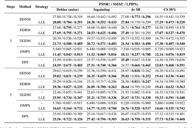
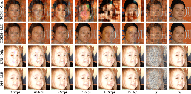

Abstract:Diffusion models have demonstrated remarkable performance in modeling complex data priors, catalyzing their widespread adoption in solving various inverse problems. However, the inherently iterative nature of diffusion-based inverse algorithms often requires hundreds to thousands of steps, with performance degradation occurring under fewer steps which limits their practical applicability. While high-order diffusion ODE solvers have been extensively explored for efficient diffusion sampling without observations, their application to inverse problems remains underexplored due to the diverse forms of inverse algorithms and their need for repeated trajectory correction based on observations. To address this gap, we first introduce a canonical form that decomposes existing diffusion-based inverse algorithms into three modules to unify their analysis. Inspired by the linear subspace search strategy in the design of high-order diffusion ODE solvers, we propose the Learnable Linear Extrapolation (LLE) method, a lightweight approach that universally enhances the performance of any diffusion-based inverse algorithm that fits the proposed canonical form. Extensive experiments demonstrate consistent improvements of the proposed LLE method across multiple algorithms and tasks, indicating its potential for more efficient solutions and boosted performance of diffusion-based inverse algorithms with limited steps. Codes for reproducing our experiments are available at \href{https://github.com/weigerzan/LLE_inverse_problem}{https://github.com/weigerzan/LLE\_inverse\_problem}.
JL1-CD: A New Benchmark for Remote Sensing Change Detection and a Robust Multi-Teacher Knowledge Distillation Framework
Feb 19, 2025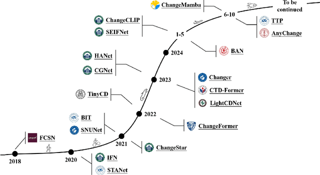
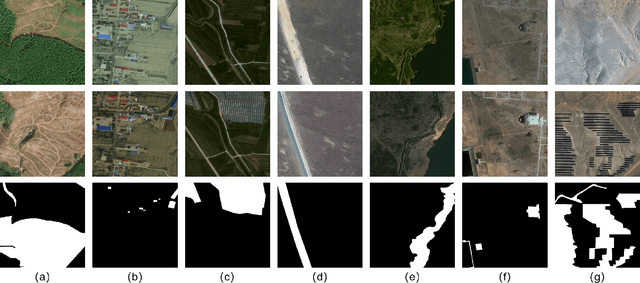
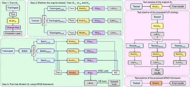
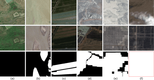
Abstract:Deep learning has achieved significant success in the field of remote sensing image change detection (CD), yet two major challenges remain: the scarcity of sub-meter, all-inclusive open-source CD datasets, and the difficulty of achieving consistent and satisfactory detection results across images with varying change areas. To address these issues, we introduce the JL1-CD dataset, which contains 5,000 pairs of 512 x 512 pixel images with a resolution of 0.5 to 0.75 meters. Additionally, we propose a multi-teacher knowledge distillation (MTKD) framework for CD. Experimental results on the JL1-CD and SYSU-CD datasets demonstrate that the MTKD framework significantly improves the performance of CD models with various network architectures and parameter sizes, achieving new state-of-the-art results. The code is available at https://github.com/circleLZY/MTKD-CD.
ConsistentDreamer: View-Consistent Meshes Through Balanced Multi-View Gaussian Optimization
Feb 13, 2025Abstract:Recent advances in diffusion models have significantly improved 3D generation, enabling the use of assets generated from an image for embodied AI simulations. However, the one-to-many nature of the image-to-3D problem limits their use due to inconsistent content and quality across views. Previous models optimize a 3D model by sampling views from a view-conditioned diffusion prior, but diffusion models cannot guarantee view consistency. Instead, we present ConsistentDreamer, where we first generate a set of fixed multi-view prior images and sample random views between them with another diffusion model through a score distillation sampling (SDS) loss. Thereby, we limit the discrepancies between the views guided by the SDS loss and ensure a consistent rough shape. In each iteration, we also use our generated multi-view prior images for fine-detail reconstruction. To balance between the rough shape and the fine-detail optimizations, we introduce dynamic task-dependent weights based on homoscedastic uncertainty, updated automatically in each iteration. Additionally, we employ opacity, depth distortion, and normal alignment losses to refine the surface for mesh extraction. Our method ensures better view consistency and visual quality compared to the state-of-the-art.
 Add to Chrome
 Add to Firefox
 Add to Edge