Xiangyong Cao
Exchange Is All You Need for Remote Sensing Change Detection
Jan 12, 2026Abstract:Remote sensing change detection fundamentally relies on the effective fusion and discrimination of bi-temporal features. Prevailing paradigms typically utilize Siamese encoders bridged by explicit difference computation modules, such as subtraction or concatenation, to identify changes. In this work, we challenge this complexity with SEED (Siamese Encoder-Exchange-Decoder), a streamlined paradigm that replaces explicit differencing with parameter-free feature exchange. By sharing weights across both Siamese encoders and decoders, SEED effectively operates as a single parameter set model. Theoretically, we formalize feature exchange as an orthogonal permutation operator and prove that, under pixel consistency, this mechanism preserves mutual information and Bayes optimal risk, whereas common arithmetic fusion methods often introduce information loss. Extensive experiments across five benchmarks, including SYSU-CD, LEVIR-CD, PX-CLCD, WaterCD, and CDD, and three backbones, namely SwinT, EfficientNet, and ResNet, demonstrate that SEED matches or surpasses state of the art methods despite its simplicity. Furthermore, we reveal that standard semantic segmentation models can be transformed into competitive change detectors solely by inserting this exchange mechanism, referred to as SEG2CD. The proposed paradigm offers a robust, unified, and interpretable framework for change detection, demonstrating that simple feature exchange is sufficient for high performance information fusion. Code and full training and evaluation protocols will be released at https://github.com/dyzy41/open-rscd.
SegEarth-R2: Towards Comprehensive Language-guided Segmentation for Remote Sensing Images
Dec 23, 2025Abstract:Effectively grounding complex language to pixels in remote sensing (RS) images is a critical challenge for applications like disaster response and environmental monitoring. Current models can parse simple, single-target commands but fail when presented with complex geospatial scenarios, e.g., segmenting objects at various granularities, executing multi-target instructions, and interpreting implicit user intent. To drive progress against these failures, we present LaSeRS, the first large-scale dataset built for comprehensive training and evaluation across four critical dimensions of language-guided segmentation: hierarchical granularity, target multiplicity, reasoning requirements, and linguistic variability. By capturing these dimensions, LaSeRS moves beyond simple commands, providing a benchmark for complex geospatial reasoning. This addresses a critical gap: existing datasets oversimplify, leading to sensitivity-prone real-world models. We also propose SegEarth-R2, an MLLM architecture designed for comprehensive language-guided segmentation in RS, which directly confronts these challenges. The model's effectiveness stems from two key improvements: (1) a spatial attention supervision mechanism specifically handles the localization of small objects and their components, and (2) a flexible and efficient segmentation query mechanism that handles both single-target and multi-target scenarios. Experimental results demonstrate that our SegEarth-R2 achieves outstanding performance on LaSeRS and other benchmarks, establishing a powerful baseline for the next generation of geospatial segmentation. All data and code will be released at https://github.com/earth-insights/SegEarth-R2.
SegEarth-OV3: Exploring SAM 3 for Open-Vocabulary Semantic Segmentation in Remote Sensing Images
Dec 09, 2025Abstract:Most existing methods for training-free Open-Vocabulary Semantic Segmentation (OVSS) are based on CLIP. While these approaches have made progress, they often face challenges in precise localization or require complex pipelines to combine separate modules, especially in remote sensing scenarios where numerous dense and small targets are present. Recently, Segment Anything Model 3 (SAM 3) was proposed, unifying segmentation and recognition in a promptable framework. In this paper, we present a preliminary exploration of applying SAM 3 to the remote sensing OVSS task without any training. First, we implement a mask fusion strategy that combines the outputs from SAM 3's semantic segmentation head and the Transformer decoder (instance head). This allows us to leverage the strengths of both heads for better land coverage. Second, we utilize the presence score from the presence head to filter out categories that do not exist in the scene, reducing false positives caused by the vast vocabulary sizes and patch-level processing in geospatial scenes. We evaluate our method on extensive remote sensing datasets. Experiments show that this simple adaptation achieves promising performance, demonstrating the potential of SAM 3 for remote sensing OVSS. Our code is released at https://github.com/earth-insights/SegEarth-OV-3.
ZoomEarth: Active Perception for Ultra-High-Resolution Geospatial Vision-Language Tasks
Nov 15, 2025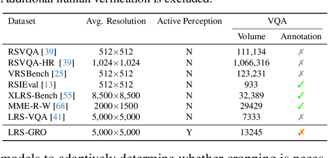
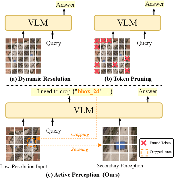
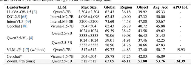
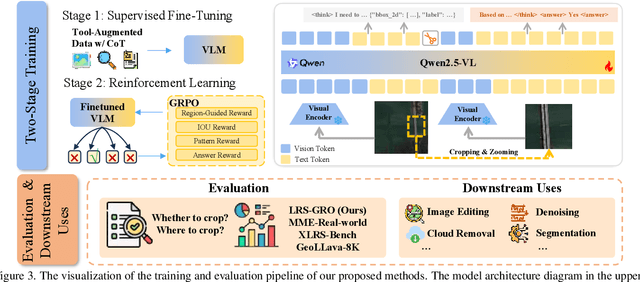
Abstract:Ultra-high-resolution (UHR) remote sensing (RS) images offer rich fine-grained information but also present challenges in effective processing. Existing dynamic resolution and token pruning methods are constrained by a passive perception paradigm, suffering from increased redundancy when obtaining finer visual inputs. In this work, we explore a new active perception paradigm that enables models to revisit information-rich regions. First, we present LRS-GRO, a large-scale benchmark dataset tailored for active perception in UHR RS processing, encompassing 17 question types across global, region, and object levels, annotated via a semi-automatic pipeline. Building on LRS-GRO, we propose ZoomEarth, an adaptive cropping-zooming framework with a novel Region-Guided reward that provides fine-grained guidance. Trained via supervised fine-tuning (SFT) and Group Relative Policy Optimization (GRPO), ZoomEarth achieves state-of-the-art performance on LRS-GRO and, in the zero-shot setting, on three public UHR remote sensing benchmarks. Furthermore, ZoomEarth can be seamlessly integrated with downstream models for tasks such as cloud removal, denoising, segmentation, and image editing through simple tool interfaces, demonstrating strong versatility and extensibility.
Annotation-Free Open-Vocabulary Segmentation for Remote-Sensing Images
Aug 25, 2025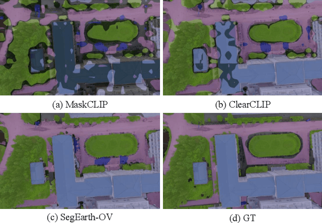
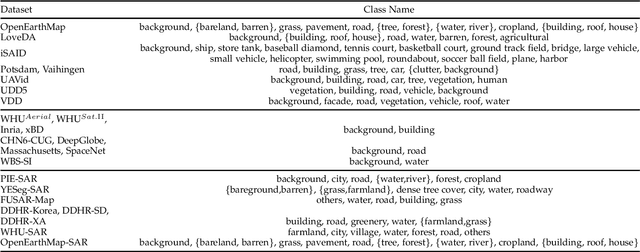
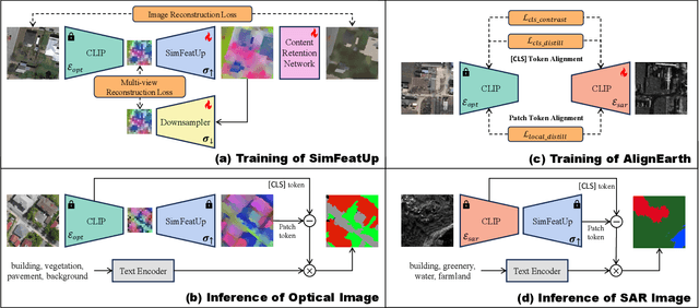

Abstract:Semantic segmentation of remote sensing (RS) images is pivotal for comprehensive Earth observation, but the demand for interpreting new object categories, coupled with the high expense of manual annotation, poses significant challenges. Although open-vocabulary semantic segmentation (OVSS) offers a promising solution, existing frameworks designed for natural images are insufficient for the unique complexities of RS data. They struggle with vast scale variations and fine-grained details, and their adaptation often relies on extensive, costly annotations. To address this critical gap, this paper introduces SegEarth-OV, the first framework for annotation-free open-vocabulary segmentation of RS images. Specifically, we propose SimFeatUp, a universal upsampler that robustly restores high-resolution spatial details from coarse features, correcting distorted target shapes without any task-specific post-training. We also present a simple yet effective Global Bias Alleviation operation to subtract the inherent global context from patch features, significantly enhancing local semantic fidelity. These components empower SegEarth-OV to effectively harness the rich semantics of pre-trained VLMs, making OVSS possible in optical RS contexts. Furthermore, to extend the framework's universality to other challenging RS modalities like SAR images, where large-scale VLMs are unavailable and expensive to create, we introduce AlignEarth, which is a distillation-based strategy and can efficiently transfer semantic knowledge from an optical VLM encoder to an SAR encoder, bypassing the need to build SAR foundation models from scratch and enabling universal OVSS across diverse sensor types. Extensive experiments on both optical and SAR datasets validate that SegEarth-OV can achieve dramatic improvements over the SOTA methods, establishing a robust foundation for annotation-free and open-world Earth observation.
RS-MTDF: Multi-Teacher Distillation and Fusion for Remote Sensing Semi-Supervised Semantic Segmentation
Jun 11, 2025Abstract:Semantic segmentation in remote sensing images is crucial for various applications, yet its performance is heavily reliant on large-scale, high-quality pixel-wise annotations, which are notoriously expensive and time-consuming to acquire. Semi-supervised semantic segmentation (SSS) offers a promising alternative to mitigate this data dependency. However, existing SSS methods often struggle with the inherent distribution mismatch between limited labeled data and abundant unlabeled data, leading to suboptimal generalization. To alleviate this issue, we attempt to introduce the Vision Foundation Models (VFMs) pre-trained on vast and diverse datasets into the SSS task since VFMs possess robust generalization capabilities that can effectively bridge this distribution gap and provide strong semantic priors for SSS. Inspired by this, we introduce RS-MTDF (Multi-Teacher Distillation and Fusion), a novel framework that leverages the powerful semantic knowledge embedded in VFMs to guide semi-supervised learning in remote sensing. Specifically, RS-MTDF employs multiple frozen VFMs (e.g., DINOv2 and CLIP) as expert teachers, utilizing feature-level distillation to align student features with their robust representations. To further enhance discriminative power, the distilled knowledge is seamlessly fused into the student decoder. Extensive experiments on three challenging remote sensing datasets demonstrate that RS-MTDF consistently achieves state-of-the-art performance. Notably, our method outperforms existing approaches across various label ratios on LoveDA and secures the highest IoU in the majority of semantic categories. These results underscore the efficacy of multi-teacher VFM guidance in significantly enhancing both generalization and semantic understanding for remote sensing segmentation. Ablation studies further validate the contribution of each proposed module.
Hyperspectral Anomaly Detection Fused Unified Nonconvex Tensor Ring Factors Regularization
May 23, 2025Abstract:In recent years, tensor decomposition-based approaches for hyperspectral anomaly detection (HAD) have gained significant attention in the field of remote sensing. However, existing methods often fail to fully leverage both the global correlations and local smoothness of the background components in hyperspectral images (HSIs), which exist in both the spectral and spatial domains. This limitation results in suboptimal detection performance. To mitigate this critical issue, we put forward a novel HAD method named HAD-EUNTRFR, which incorporates an enhanced unified nonconvex tensor ring (TR) factors regularization. In the HAD-EUNTRFR framework, the raw HSIs are first decomposed into background and anomaly components. The TR decomposition is then employed to capture the spatial-spectral correlations within the background component. Additionally, we introduce a unified and efficient nonconvex regularizer, induced by tensor singular value decomposition (TSVD), to simultaneously encode the low-rankness and sparsity of the 3-D gradient TR factors into a unique concise form. The above characterization scheme enables the interpretable gradient TR factors to inherit the low-rankness and smoothness of the original background. To further enhance anomaly detection, we design a generalized nonconvex regularization term to exploit the group sparsity of the anomaly component. To solve the resulting doubly nonconvex model, we develop a highly efficient optimization algorithm based on the alternating direction method of multipliers (ADMM) framework. Experimental results on several benchmark datasets demonstrate that our proposed method outperforms existing state-of-the-art (SOTA) approaches in terms of detection accuracy.
Motion-Enhanced Nonlocal Similarity Implicit Neural Representation for Infrared Dim and Small Target Detection
Apr 22, 2025Abstract:Infrared dim and small target detection presents a significant challenge due to dynamic multi-frame scenarios and weak target signatures in the infrared modality. Traditional low-rank plus sparse models often fail to capture dynamic backgrounds and global spatial-temporal correlations, which results in background leakage or target loss. In this paper, we propose a novel motion-enhanced nonlocal similarity implicit neural representation (INR) framework to address these challenges. We first integrate motion estimation via optical flow to capture subtle target movements, and propose multi-frame fusion to enhance motion saliency. Second, we leverage nonlocal similarity to construct patch tensors with strong low-rank properties, and propose an innovative tensor decomposition-based INR model to represent the nonlocal patch tensor, effectively encoding both the nonlocal low-rankness and spatial-temporal correlations of background through continuous neural representations. An alternating direction method of multipliers is developed for the nonlocal INR model, which enjoys theoretical fixed-point convergence. Experimental results show that our approach robustly separates dim targets from complex infrared backgrounds, outperforming state-of-the-art methods in detection accuracy and robustness.
SegEarth-R1: Geospatial Pixel Reasoning via Large Language Model
Apr 13, 2025Abstract:Remote sensing has become critical for understanding environmental dynamics, urban planning, and disaster management. However, traditional remote sensing workflows often rely on explicit segmentation or detection methods, which struggle to handle complex, implicit queries that require reasoning over spatial context, domain knowledge, and implicit user intent. Motivated by this, we introduce a new task, \ie, geospatial pixel reasoning, which allows implicit querying and reasoning and generates the mask of the target region. To advance this task, we construct and release the first large-scale benchmark dataset called EarthReason, which comprises 5,434 manually annotated image masks with over 30,000 implicit question-answer pairs. Moreover, we propose SegEarth-R1, a simple yet effective language-guided segmentation baseline that integrates a hierarchical visual encoder, a large language model (LLM) for instruction parsing, and a tailored mask generator for spatial correlation. The design of SegEarth-R1 incorporates domain-specific adaptations, including aggressive visual token compression to handle ultra-high-resolution remote sensing images, a description projection module to fuse language and multi-scale features, and a streamlined mask prediction pipeline that directly queries description embeddings. Extensive experiments demonstrate that SegEarth-R1 achieves state-of-the-art performance on both reasoning and referring segmentation tasks, significantly outperforming traditional and LLM-based segmentation methods. Our data and code will be released at https://github.com/earth-insights/SegEarth-R1.
SPECIAL: Zero-shot Hyperspectral Image Classification With CLIP
Jan 27, 2025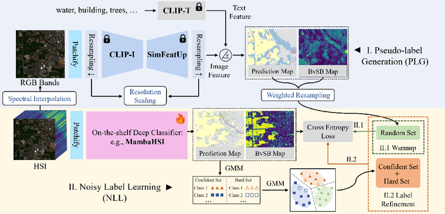

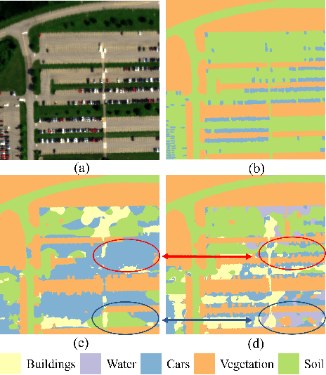

Abstract:Hyperspectral image (HSI) classification aims at categorizing each pixel in an HSI into a specific land cover class, which is crucial for applications like remote sensing, environmental monitoring, and agriculture. Although deep learning-based HSI classification methods have achieved significant advancements, existing methods still rely on manually labeled data for training, which is both time-consuming and labor-intensive.To address this limitation, we introduce a novel zero-shot hyperspectral image classification framework based on CLIP (SPECIAL), aiming to eliminate the need for manual annotations. The SPECIAL framework consists of two main stages: (1) CLIP-based pseudo-label generation, and (2) noisy label learning. In the first stage, HSI is spectrally interpolated to produce RGB bands. These bands are subsequently classified using CLIP, resulting in noisy pseudo-labels that are accompanied by confidence scores.To improve the quality of these labels, we propose a scaling strategy that fuses predictions from multiple spatial scales. In the second stage, spectral information and a label refinement technique are incorporated to mitigate label noise and further enhance classification accuracy. Experimental results on three benchmark datasets demonstrate that our SPECIAL outperforms existing methods in zero-shot HSI classification, showing its potential for more practical applications. The code is available at https://github.com/LiPang/SPECIAL.
 Add to Chrome
 Add to Firefox
 Add to Edge