Xin Kong
KV-Tracker: Real-Time Pose Tracking with Transformers
Dec 27, 2025Abstract:Multi-view 3D geometry networks offer a powerful prior but are prohibitively slow for real-time applications. We propose a novel way to adapt them for online use, enabling real-time 6-DoF pose tracking and online reconstruction of objects and scenes from monocular RGB videos. Our method rapidly selects and manages a set of images as keyframes to map a scene or object via $π^3$ with full bidirectional attention. We then cache the global self-attention block's key-value (KV) pairs and use them as the sole scene representation for online tracking. This allows for up to $15\times$ speedup during inference without the fear of drift or catastrophic forgetting. Our caching strategy is model-agnostic and can be applied to other off-the-shelf multi-view networks without retraining. We demonstrate KV-Tracker on both scene-level tracking and the more challenging task of on-the-fly object tracking and reconstruction without depth measurements or object priors. Experiments on the TUM RGB-D, 7-Scenes, Arctic and OnePose datasets show the strong performance of our system while maintaining high frame-rates up to ${\sim}27$ FPS.
EscherNet: A Generative Model for Scalable View Synthesis
Feb 06, 2024Abstract:We introduce EscherNet, a multi-view conditioned diffusion model for view synthesis. EscherNet learns implicit and generative 3D representations coupled with a specialised camera positional encoding, allowing precise and continuous relative control of the camera transformation between an arbitrary number of reference and target views. EscherNet offers exceptional generality, flexibility, and scalability in view synthesis -- it can generate more than 100 consistent target views simultaneously on a single consumer-grade GPU, despite being trained with a fixed number of 3 reference views to 3 target views. As a result, EscherNet not only addresses zero-shot novel view synthesis, but also naturally unifies single- and multi-image 3D reconstruction, combining these diverse tasks into a single, cohesive framework. Our extensive experiments demonstrate that EscherNet achieves state-of-the-art performance in multiple benchmarks, even when compared to methods specifically tailored for each individual problem. This remarkable versatility opens up new directions for designing scalable neural architectures for 3D vision. Project page: \url{https://kxhit.github.io/EscherNet}.
vMAP: Vectorised Object Mapping for Neural Field SLAM
Feb 03, 2023
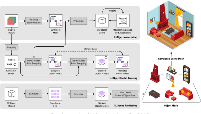

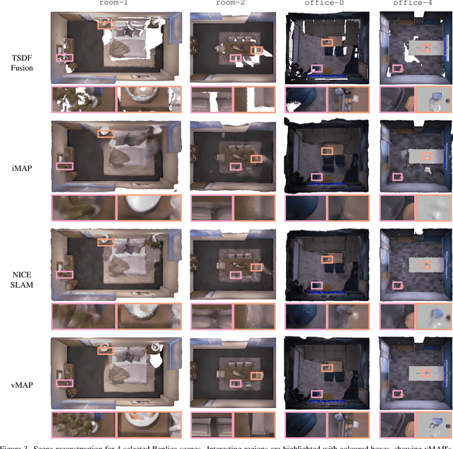
Abstract:We present vMAP, an object-level dense SLAM system using neural field representations. Each object is represented by a small MLP, enabling efficient, watertight object modelling without the need for 3D priors. As an RGB-D camera browses a scene with no prior information, vMAP detects object instances on-the-fly, and dynamically adds them to its map. Specifically, thanks to the power of vectorised training, vMAP can optimise as many as 50 individual objects in a single scene, with an extremely efficient training speed of 5Hz map update. We experimentally demonstrate significantly improved scene-level and object-level reconstruction quality compared to prior neural field SLAM systems.
DA$^2$ Dataset: Toward Dexterity-Aware Dual-Arm Grasping
Jul 31, 2022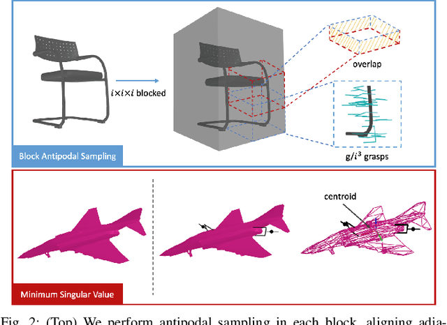

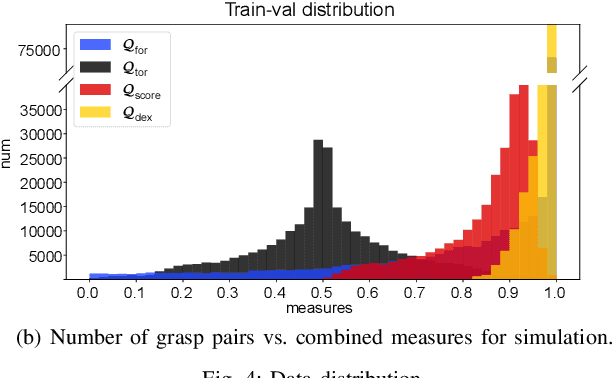
Abstract:In this paper, we introduce DA$^2$, the first large-scale dual-arm dexterity-aware dataset for the generation of optimal bimanual grasping pairs for arbitrary large objects. The dataset contains about 9M pairs of parallel-jaw grasps, generated from more than 6000 objects and each labeled with various grasp dexterity measures. In addition, we propose an end-to-end dual-arm grasp evaluation model trained on the rendered scenes from this dataset. We utilize the evaluation model as our baseline to show the value of this novel and nontrivial dataset by both online analysis and real robot experiments. All data and related code will be open-sourced at https://sites.google.com/view/da2dataset.
Semantic Segmentation-assisted Scene Completion for LiDAR Point Clouds
Sep 23, 2021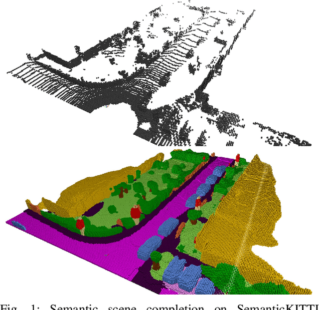
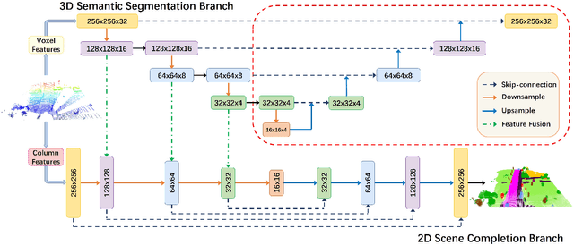
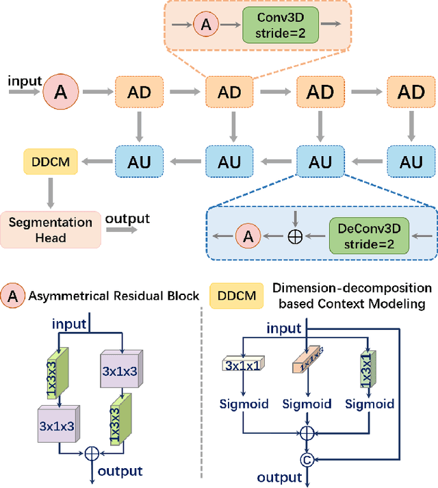
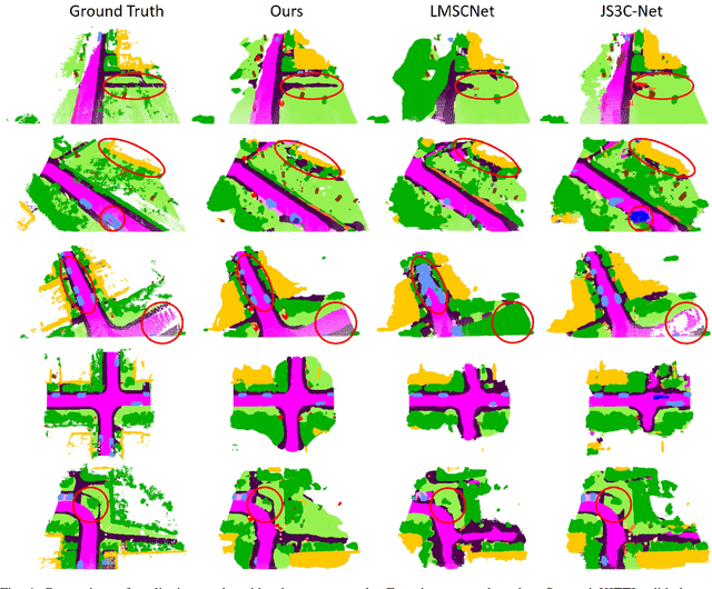
Abstract:Outdoor scene completion is a challenging issue in 3D scene understanding, which plays an important role in intelligent robotics and autonomous driving. Due to the sparsity of LiDAR acquisition, it is far more complex for 3D scene completion and semantic segmentation. Since semantic features can provide constraints and semantic priors for completion tasks, the relationship between them is worth exploring. Therefore, we propose an end-to-end semantic segmentation-assisted scene completion network, including a 2D completion branch and a 3D semantic segmentation branch. Specifically, the network takes a raw point cloud as input, and merges the features from the segmentation branch into the completion branch hierarchically to provide semantic information. By adopting BEV representation and 3D sparse convolution, we can benefit from the lower operand while maintaining effective expression. Besides, the decoder of the segmentation branch is used as an auxiliary, which can be discarded in the inference stage to save computational consumption. Extensive experiments demonstrate that our method achieves competitive performance on SemanticKITTI dataset with low latency. Code and models will be released at https://github.com/jokester-zzz/SSA-SC.
SSC: Semantic Scan Context for Large-Scale Place Recognition
Jul 10, 2021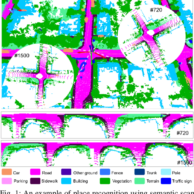

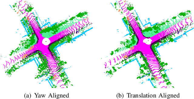
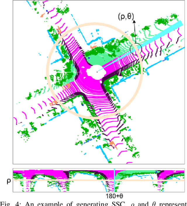
Abstract:Place recognition gives a SLAM system the ability to correct cumulative errors. Unlike images that contain rich texture features, point clouds are almost pure geometric information which makes place recognition based on point clouds challenging. Existing works usually encode low-level features such as coordinate, normal, reflection intensity, etc., as local or global descriptors to represent scenes. Besides, they often ignore the translation between point clouds when matching descriptors. Different from most existing methods, we explore the use of high-level features, namely semantics, to improve the descriptor's representation ability. Also, when matching descriptors, we try to correct the translation between point clouds to improve accuracy. Concretely, we propose a novel global descriptor, Semantic Scan Context, which explores semantic information to represent scenes more effectively. We also present a two-step global semantic ICP to obtain the 3D pose (x, y, yaw) used to align the point cloud to improve matching performance. Our experiments on the KITTI dataset show that our approach outperforms the state-of-the-art methods with a large margin. Our code is available at: https://github.com/lilin-hitcrt/SSC.
SA-LOAM: Semantic-aided LiDAR SLAM with Loop Closure
Jul 01, 2021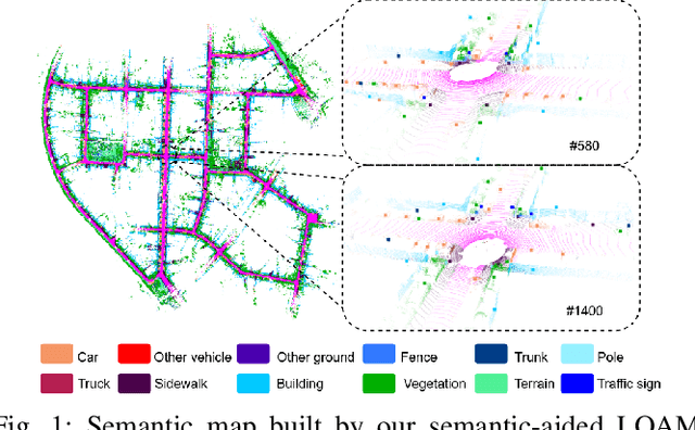
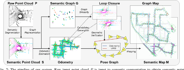
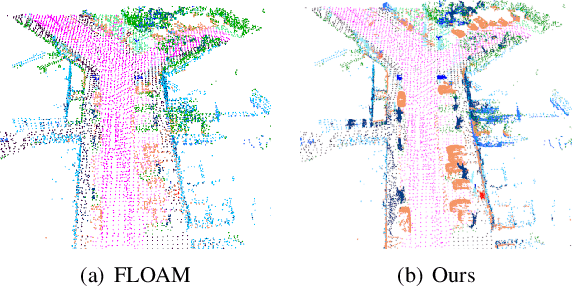
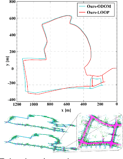
Abstract:LiDAR-based SLAM system is admittedly more accurate and stable than others, while its loop closure detection is still an open issue. With the development of 3D semantic segmentation for point cloud, semantic information can be obtained conveniently and steadily, essential for high-level intelligence and conductive to SLAM. In this paper, we present a novel semantic-aided LiDAR SLAM with loop closure based on LOAM, named SA-LOAM, which leverages semantics in odometry as well as loop closure detection. Specifically, we propose a semantic-assisted ICP, including semantically matching, downsampling and plane constraint, and integrates a semantic graph-based place recognition method in our loop closure detection module. Benefitting from semantics, we can improve the localization accuracy, detect loop closures effectively, and construct a global consistent semantic map even in large-scale scenes. Extensive experiments on KITTI and Ford Campus dataset show that our system significantly improves baseline performance, has generalization ability to unseen data and achieves competitive results compared with state-of-the-art methods.
FlowMOT: 3D Multi-Object Tracking by Scene Flow Association
Dec 15, 2020


Abstract:Most end-to-end Multi-Object Tracking (MOT) methods face the problems of low accuracy and poor generalization ability. Although traditional filter-based methods can achieve better results, they are difficult to be endowed with optimal hyperparameters and often fail in varying scenarios. To alleviate these drawbacks, we propose a LiDAR-based 3D MOT framework named FlowMOT, which integrates point-wise motion information into the traditional matching algorithm, enhancing the robustness of the data association. We firstly utilize a scene flow estimation network to obtain implicit motion information between two adjacent frames and calculate the predicted detection for each old tracklet in the previous frame. Then we use Hungarian algorithm to generate optimal matching relations with the ID propagation strategy to finish the tracking task. Experiments on KITTI MOT dataset show that our approach outperforms recent end-to-end methods and achieves competitive performance with the state-of-the-art filter-based method. In addition, ours can work steadily in the various-speed scenes where the filter-based methods may fail.
HR-Depth: High Resolution Self-Supervised Monocular Depth Estimation
Dec 14, 2020


Abstract:Self-supervised learning shows great potential in monoculardepth estimation, using image sequences as the only source ofsupervision. Although people try to use the high-resolutionimage for depth estimation, the accuracy of prediction hasnot been significantly improved. In this work, we find thecore reason comes from the inaccurate depth estimation inlarge gradient regions, making the bilinear interpolation er-ror gradually disappear as the resolution increases. To obtainmore accurate depth estimation in large gradient regions, itis necessary to obtain high-resolution features with spatialand semantic information. Therefore, we present an improvedDepthNet, HR-Depth, with two effective strategies: (1) re-design the skip-connection in DepthNet to get better high-resolution features and (2) propose feature fusion Squeeze-and-Excitation(fSE) module to fuse feature more efficiently.Using Resnet-18 as the encoder, HR-Depth surpasses all pre-vious state-of-the-art(SoTA) methods with the least param-eters at both high and low resolution. Moreover, previousstate-of-the-art methods are based on fairly complex and deepnetworks with a mass of parameters which limits their realapplications. Thus we also construct a lightweight networkwhich uses MobileNetV3 as encoder. Experiments show thatthe lightweight network can perform on par with many largemodels like Monodepth2 at high-resolution with only20%parameters. All codes and models will be available at https://github.com/shawLyu/HR-Depth.
F-Siamese Tracker: A Frustum-based Double Siamese Network for 3D Single Object Tracking
Oct 22, 2020
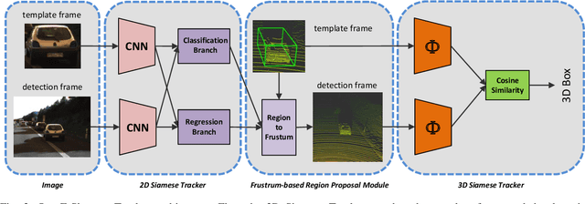
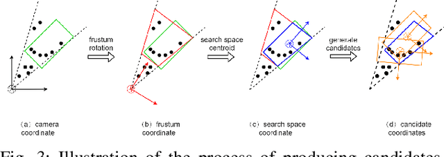
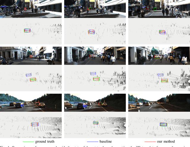
Abstract:This paper presents F-Siamese Tracker, a novel approach for single object tracking prominently characterized by more robustly integrating 2D and 3D information to reduce redundant search space. A main challenge in 3D single object tracking is how to reduce search space for generating appropriate 3D candidates. Instead of solely relying on 3D proposals, firstly, our method leverages the Siamese network applied on RGB images to produce 2D region proposals which are then extruded into 3D viewing frustums. Besides, we perform an online accuracy validation on the 3D frustum to generate refined point cloud searching space, which can be embedded directly into the existing 3D tracking backbone. For efficiency, our approach gains better performance with fewer candidates by reducing search space. In addition, benefited from introducing the online accuracy validation, for occasional cases with strong occlusions or very sparse points, our approach can still achieve high precision, even when the 2D Siamese tracker loses the target. This approach allows us to set a new state-of-the-art in 3D single object tracking by a significant margin on a sparse outdoor dataset (KITTI tracking). Moreover, experiments on 2D single object tracking show that our framework boosts 2D tracking performance as well.
 Add to Chrome
 Add to Firefox
 Add to Edge