Liangliang Nan
AsyncBEV: Cross-modal Flow Alignment in Asynchronous 3D Object Detection
Jan 19, 2026Abstract:In autonomous driving, multi-modal perception tasks like 3D object detection typically rely on well-synchronized sensors, both at training and inference. However, despite the use of hardware- or software-based synchronization algorithms, perfect synchrony is rarely guaranteed: Sensors may operate at different frequencies, and real-world factors such as network latency, hardware failures, or processing bottlenecks often introduce time offsets between sensors. Such asynchrony degrades perception performance, especially for dynamic objects. To address this challenge, we propose AsyncBEV, a trainable lightweight and generic module to improve the robustness of 3D Birds' Eye View (BEV) object detection models against sensor asynchrony. Inspired by scene flow estimation, AsyncBEV first estimates the 2D flow from the BEV features of two different sensor modalities, taking into account the known time offset between these sensor measurements. The predicted feature flow is then used to warp and spatially align the feature maps, which we show can easily be integrated into different current BEV detector architectures (e.g., BEV grid-based and token-based). Extensive experiments demonstrate AsyncBEV improves robustness against both small and large asynchrony between LiDAR or camera sensors in both the token-based CMT and grid-based UniBEV, especially for dynamic objects. We significantly outperform the ego motion compensated CMT and UniBEV baselines, notably by $16.6$ % and $11.9$ % NDS on dynamic objects in the worst-case scenario of a $0.5 s$ time offset. Code will be released upon acceptance.
I Speak and You Find: Robust 3D Visual Grounding with Noisy and Ambiguous Speech Inputs
Jun 17, 2025Abstract:Existing 3D visual grounding methods rely on precise text prompts to locate objects within 3D scenes. Speech, as a natural and intuitive modality, offers a promising alternative. Real-world speech inputs, however, often suffer from transcription errors due to accents, background noise, and varying speech rates, limiting the applicability of existing 3DVG methods. To address these challenges, we propose \textbf{SpeechRefer}, a novel 3DVG framework designed to enhance performance in the presence of noisy and ambiguous speech-to-text transcriptions. SpeechRefer integrates seamlessly with xisting 3DVG models and introduces two key innovations. First, the Speech Complementary Module captures acoustic similarities between phonetically related words and highlights subtle distinctions, generating complementary proposal scores from the speech signal. This reduces dependence on potentially erroneous transcriptions. Second, the Contrastive Complementary Module employs contrastive learning to align erroneous text features with corresponding speech features, ensuring robust performance even when transcription errors dominate. Extensive experiments on the SpeechRefer and peechNr3D datasets demonstrate that SpeechRefer improves the performance of existing 3DVG methods by a large margin, which highlights SpeechRefer's potential to bridge the gap between noisy speech inputs and reliable 3DVG, enabling more intuitive and practical multimodal systems.
Unified Representation Space for 3D Visual Grounding
Jun 17, 2025Abstract:3D visual grounding (3DVG) is a critical task in scene understanding that aims to identify objects in 3D scenes based on text descriptions. However, existing methods rely on separately pre-trained vision and text encoders, resulting in a significant gap between the two modalities in terms of spatial geometry and semantic categories. This discrepancy often causes errors in object positioning and classification. The paper proposes UniSpace-3D, which innovatively introduces a unified representation space for 3DVG, effectively bridging the gap between visual and textual features. Specifically, UniSpace-3D incorporates three innovative designs: i) a unified representation encoder that leverages the pre-trained CLIP model to map visual and textual features into a unified representation space, effectively bridging the gap between the two modalities; ii) a multi-modal contrastive learning module that further reduces the modality gap; iii) a language-guided query selection module that utilizes the positional and semantic information to identify object candidate points aligned with textual descriptions. Extensive experiments demonstrate that UniSpace-3D outperforms baseline models by at least 2.24% on the ScanRefer and Nr3D/Sr3D datasets. The code will be made available upon acceptance of the paper.
NeuSEditor: From Multi-View Images to Text-Guided Neural Surface Edits
May 16, 2025Abstract:Implicit surface representations are valued for their compactness and continuity, but they pose significant challenges for editing. Despite recent advancements, existing methods often fail to preserve identity and maintain geometric consistency during editing. To address these challenges, we present NeuSEditor, a novel method for text-guided editing of neural implicit surfaces derived from multi-view images. NeuSEditor introduces an identity-preserving architecture that efficiently separates scenes into foreground and background, enabling precise modifications without altering the scene-specific elements. Our geometry-aware distillation loss significantly enhances rendering and geometric quality. Our method simplifies the editing workflow by eliminating the need for continuous dataset updates and source prompting. NeuSEditor outperforms recent state-of-the-art methods like PDS and InstructNeRF2NeRF, delivering superior quantitative and qualitative results. For more visual results, visit: neuseditor.github.io.
VoteFlow: Enforcing Local Rigidity in Self-Supervised Scene Flow
Mar 28, 2025Abstract:Scene flow estimation aims to recover per-point motion from two adjacent LiDAR scans. However, in real-world applications such as autonomous driving, points rarely move independently of others, especially for nearby points belonging to the same object, which often share the same motion. Incorporating this locally rigid motion constraint has been a key challenge in self-supervised scene flow estimation, which is often addressed by post-processing or appending extra regularization. While these approaches are able to improve the rigidity of predicted flows, they lack an architectural inductive bias for local rigidity within the model structure, leading to suboptimal learning efficiency and inferior performance. In contrast, we enforce local rigidity with a lightweight add-on module in neural network design, enabling end-to-end learning. We design a discretized voting space that accommodates all possible translations and then identify the one shared by nearby points by differentiable voting. Additionally, to ensure computational efficiency, we operate on pillars rather than points and learn representative features for voting per pillar. We plug the Voting Module into popular model designs and evaluate its benefit on Argoverse 2 and Waymo datasets. We outperform baseline works with only marginal compute overhead. Code is available at https://github.com/tudelft-iv/VoteFlow.
SUM Parts: Benchmarking Part-Level Semantic Segmentation of Urban Meshes
Mar 21, 2025Abstract:Semantic segmentation in urban scene analysis has mainly focused on images or point clouds, while textured meshes - offering richer spatial representation - remain underexplored. This paper introduces SUM Parts, the first large-scale dataset for urban textured meshes with part-level semantic labels, covering about 2.5 km2 with 21 classes. The dataset was created using our own annotation tool, which supports both face- and texture-based annotations with efficient interactive selection. We also provide a comprehensive evaluation of 3D semantic segmentation and interactive annotation methods on this dataset. Our project page is available at https://tudelft3d.github.io/SUMParts/.
PointSFDA: Source-free Domain Adaptation for Point Cloud Completion
Mar 19, 2025


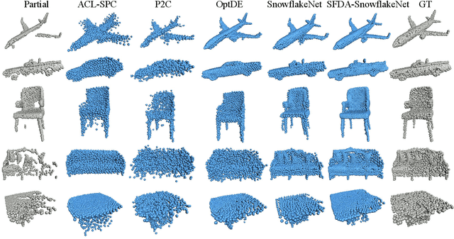
Abstract:Conventional methods for point cloud completion, typically trained on synthetic datasets, face significant challenges when applied to out-of-distribution real-world scans. In this paper, we propose an effective yet simple source-free domain adaptation framework for point cloud completion, termed \textbf{PointSFDA}. Unlike unsupervised domain adaptation that reduces the domain gap by directly leveraging labeled source data, PointSFDA uses only a pretrained source model and unlabeled target data for adaptation, avoiding the need for inaccessible source data in practical scenarios. Being the first source-free domain adaptation architecture for point cloud completion, our method offers two core contributions. First, we introduce a coarse-to-fine distillation solution to explicitly transfer the global geometry knowledge learned from the source dataset. Second, as noise may be introduced due to domain gaps, we propose a self-supervised partial-mask consistency training strategy to learn local geometry information in the target domain. Extensive experiments have validated that our method significantly improves the performance of state-of-the-art networks in cross-domain shape completion. Our code is available at \emph{\textcolor{magenta}{https://github.com/Starak-x/PointSFDA}}.
Parametric Point Cloud Completion for Polygonal Surface Reconstruction
Mar 11, 2025Abstract:Existing polygonal surface reconstruction methods heavily depend on input completeness and struggle with incomplete point clouds. We argue that while current point cloud completion techniques may recover missing points, they are not optimized for polygonal surface reconstruction, where the parametric representation of underlying surfaces remains overlooked. To address this gap, we introduce parametric completion, a novel paradigm for point cloud completion, which recovers parametric primitives instead of individual points to convey high-level geometric structures. Our presented approach, PaCo, enables high-quality polygonal surface reconstruction by leveraging plane proxies that encapsulate both plane parameters and inlier points, proving particularly effective in challenging scenarios with highly incomplete data. Comprehensive evaluations of our approach on the ABC dataset establish its effectiveness with superior performance and set a new standard for polygonal surface reconstruction from incomplete data. Project page: https://parametric-completion.github.io.
CrossTracker: Robust Multi-modal 3D Multi-Object Tracking via Cross Correction
Nov 28, 2024


Abstract:The fusion of camera- and LiDAR-based detections offers a promising solution to mitigate tracking failures in 3D multi-object tracking (MOT). However, existing methods predominantly exploit camera detections to correct tracking failures caused by potential LiDAR detection problems, neglecting the reciprocal benefit of refining camera detections using LiDAR data. This limitation is rooted in their single-stage architecture, akin to single-stage object detectors, lacking a dedicated trajectory refinement module to fully exploit the complementary multi-modal information. To this end, we introduce CrossTracker, a novel two-stage paradigm for online multi-modal 3D MOT. CrossTracker operates in a coarse-to-fine manner, initially generating coarse trajectories and subsequently refining them through an independent refinement process. Specifically, CrossTracker incorporates three essential modules: i) a multi-modal modeling (M^3) module that, by fusing multi-modal information (images, point clouds, and even plane geometry extracted from images), provides a robust metric for subsequent trajectory generation. ii) a coarse trajectory generation (C-TG) module that generates initial coarse dual-stream trajectories, and iii) a trajectory refinement (TR) module that refines coarse trajectories through cross correction between camera and LiDAR streams. Comprehensive experiments demonstrate the superior performance of our CrossTracker over its eighteen competitors, underscoring its effectiveness in harnessing the synergistic benefits of camera and LiDAR sensors for robust multi-modal 3D MOT.
PointCG: Self-supervised Point Cloud Learning via Joint Completion and Generation
Nov 09, 2024


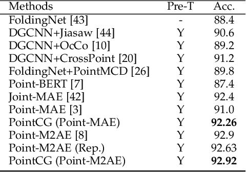
Abstract:The core of self-supervised point cloud learning lies in setting up appropriate pretext tasks, to construct a pre-training framework that enables the encoder to perceive 3D objects effectively. In this paper, we integrate two prevalent methods, masked point modeling (MPM) and 3D-to-2D generation, as pretext tasks within a pre-training framework. We leverage the spatial awareness and precise supervision offered by these two methods to address their respective limitations: ambiguous supervision signals and insensitivity to geometric information. Specifically, the proposed framework, abbreviated as PointCG, consists of a Hidden Point Completion (HPC) module and an Arbitrary-view Image Generation (AIG) module. We first capture visible points from arbitrary views as inputs by removing hidden points. Then, HPC extracts representations of the inputs with an encoder and completes the entire shape with a decoder, while AIG is used to generate rendered images based on the visible points' representations. Extensive experiments demonstrate the superiority of the proposed method over the baselines in various downstream tasks. Our code will be made available upon acceptance.
 Add to Chrome
 Add to Firefox
 Add to Edge