 Add to Chrome
 Add to Firefox
 Add to Edge
Towards Accurate and Interpretable Neuroblastoma Diagnosis via Contrastive Multi-scale Pathological Image Analysis
Apr 18, 2025


Neuroblastoma, adrenal-derived, is among the most common pediatric solid malignancies, characterized by significant clinical heterogeneity. Timely and accurate pathological diagnosis from hematoxylin and eosin-stained whole slide images is critical for patient prognosis. However, current diagnostic practices primarily rely on subjective manual examination by pathologists, leading to inconsistent accuracy. Existing automated whole slide image classification methods encounter challenges such as poor interpretability, limited feature extraction capabilities, and high computational costs, restricting their practical clinical deployment. To overcome these limitations, we propose CMSwinKAN, a contrastive-learning-based multi-scale feature fusion model tailored for pathological image classification, which enhances the Swin Transformer architecture by integrating a Kernel Activation Network within its multilayer perceptron and classification head modules, significantly improving both interpretability and accuracy. By fusing multi-scale features and leveraging contrastive learning strategies, CMSwinKAN mimics clinicians' comprehensive approach, effectively capturing global and local tissue characteristics. Additionally, we introduce a heuristic soft voting mechanism guided by clinical insights to seamlessly bridge patch-level predictions to whole slide image-level classifications. We validate CMSwinKAN on the PpNTs dataset, which was collaboratively established with our partner hospital and the publicly accessible BreakHis dataset. Results demonstrate that CMSwinKAN performs better than existing state-of-the-art pathology-specific models pre-trained on large datasets. Our source code is available at https://github.com/JSLiam94/CMSwinKAN.
Towards General Multimodal Visual Tracking
Mar 14, 2025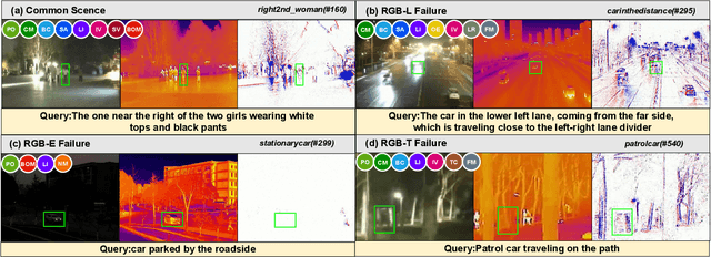
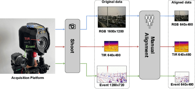
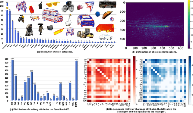
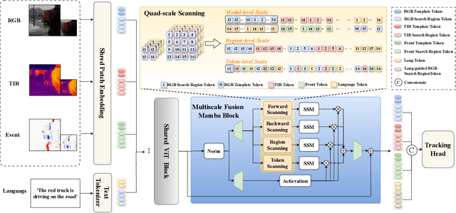
Existing multimodal tracking studies focus on bi-modal scenarios such as RGB-Thermal, RGB-Event, and RGB-Language. Although promising tracking performance is achieved through leveraging complementary cues from different sources, it remains challenging in complex scenes due to the limitations of bi-modal scenarios. In this work, we introduce a general multimodal visual tracking task that fully exploits the advantages of four modalities, including RGB, thermal infrared, event, and language, for robust tracking under challenging conditions. To provide a comprehensive evaluation platform for general multimodal visual tracking, we construct QuadTrack600, a large-scale, high-quality benchmark comprising 600 video sequences (totaling 384.7K high-resolution (640x480) frame groups). In each frame group, all four modalities are spatially aligned and meticulously annotated with bounding boxes, while 21 sequence-level challenge attributes are provided for detailed performance analysis. Despite quad-modal data provides richer information, the differences in information quantity among modalities and the computational burden from four modalities are two challenging issues in fusing four modalities. To handle these issues, we propose a novel approach called QuadFusion, which incorporates an efficient Multiscale Fusion Mamba with four different scanning scales to achieve sufficient interactions of the four modalities while overcoming the exponential computational burden, for general multimodal visual tracking. Extensive experiments on the QuadTrack600 dataset and three bi-modal tracking datasets, including LasHeR, VisEvent, and TNL2K, validate the effectiveness of our QuadFusion.
First Mapping the Canopy Height of Primeval Forests in the Tallest Tree Area of Asia
Apr 23, 2024


We have developed the world's first canopy height map of the distribution area of world-level giant trees. This mapping is crucial for discovering more individual and community world-level giant trees, and for analyzing and quantifying the effectiveness of biodiversity conservation measures in the Yarlung Tsangpo Grand Canyon (YTGC) National Nature Reserve. We proposed a method to map the canopy height of the primeval forest within the world-level giant tree distribution area by using a spaceborne LiDAR fusion satellite imagery (Global Ecosystem Dynamics Investigation (GEDI), ICESat-2, and Sentinel-2) driven deep learning modeling. And we customized a pyramid receptive fields depth separable CNN (PRFXception). PRFXception, a CNN architecture specifically customized for mapping primeval forest canopy height to infer the canopy height at the footprint level of GEDI and ICESat-2 from Sentinel-2 optical imagery with a 10-meter spatial resolution. We conducted a field survey of 227 permanent plots using a stratified sampling method and measured several giant trees using UAV-LS. The predicted canopy height was compared with ICESat-2 and GEDI validation data (RMSE =7.56 m, MAE=6.07 m, ME=-0.98 m, R^2=0.58 m), UAV-LS point clouds (RMSE =5.75 m, MAE =3.72 m, ME = 0.82 m, R^2= 0.65 m), and ground survey data (RMSE = 6.75 m, MAE = 5.56 m, ME= 2.14 m, R^2=0.60 m). We mapped the potential distribution map of world-level giant trees and discovered two previously undetected giant tree communities with an 89% probability of having trees 80-100 m tall, potentially taller than Asia's tallest tree. This paper provides scientific evidence confirming southeastern Tibet--northwestern Yunnan as the fourth global distribution center of world-level giant trees initiatives and promoting the inclusion of the YTGC giant tree distribution area within the scope of China's national park conservation.