Xingxing Zuo
MonoTher-Depth: Enhancing Thermal Depth Estimation via Confidence-Aware Distillation
Apr 21, 2025Abstract:Monocular depth estimation (MDE) from thermal images is a crucial technology for robotic systems operating in challenging conditions such as fog, smoke, and low light. The limited availability of labeled thermal data constrains the generalization capabilities of thermal MDE models compared to foundational RGB MDE models, which benefit from datasets of millions of images across diverse scenarios. To address this challenge, we introduce a novel pipeline that enhances thermal MDE through knowledge distillation from a versatile RGB MDE model. Our approach features a confidence-aware distillation method that utilizes the predicted confidence of the RGB MDE to selectively strengthen the thermal MDE model, capitalizing on the strengths of the RGB model while mitigating its weaknesses. Our method significantly improves the accuracy of the thermal MDE, independent of the availability of labeled depth supervision, and greatly expands its applicability to new scenarios. In our experiments on new scenarios without labeled depth, the proposed confidence-aware distillation method reduces the absolute relative error of thermal MDE by 22.88\% compared to the baseline without distillation.
* 8 Pages; The code will be available at https://github.com/ZuoJiaxing/monother_depth
L2COcc: Lightweight Camera-Centric Semantic Scene Completion via Distillation of LiDAR Model
Mar 16, 2025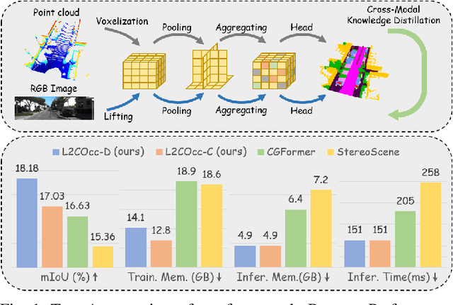
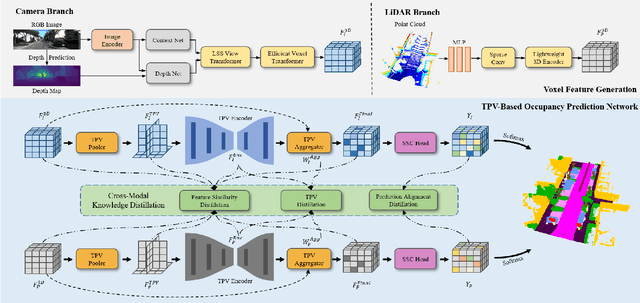
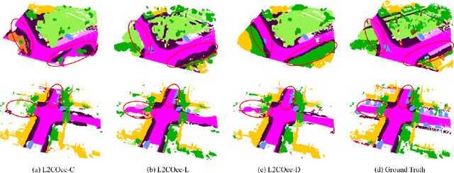
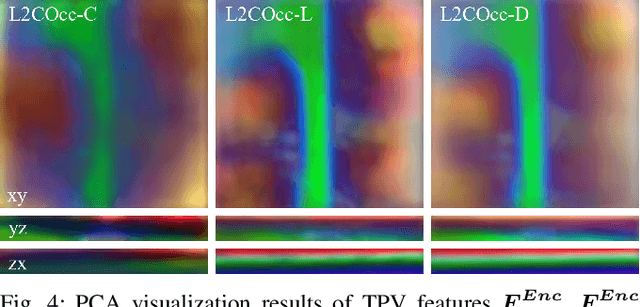
Abstract:Semantic Scene Completion (SSC) constitutes a pivotal element in autonomous driving perception systems, tasked with inferring the 3D semantic occupancy of a scene from sensory data. To improve accuracy, prior research has implemented various computationally demanding and memory-intensive 3D operations, imposing significant computational requirements on the platform during training and testing. This paper proposes L2COcc, a lightweight camera-centric SSC framework that also accommodates LiDAR inputs. With our proposed efficient voxel transformer (EVT) and cross-modal knowledge modules, including feature similarity distillation (FSD), TPV distillation (TPVD) and prediction alignment distillation (PAD), our method substantially reduce computational burden while maintaining high accuracy. The experimental evaluations demonstrate that our proposed method surpasses the current state-of-the-art vision-based SSC methods regarding accuracy on both the SemanticKITTI and SSCBench-KITTI-360 benchmarks, respectively. Additionally, our method is more lightweight, exhibiting a reduction in both memory consumption and inference time by over 23% compared to the current state-of-the-arts method. Code is available at our project page:https://studyingfufu.github.io/L2COcc/.
PG-SLAM: Photo-realistic and Geometry-aware RGB-D SLAM in Dynamic Environments
Nov 24, 2024


Abstract:Simultaneous localization and mapping (SLAM) has achieved impressive performance in static environments. However, SLAM in dynamic environments remains an open question. Many methods directly filter out dynamic objects, resulting in incomplete scene reconstruction and limited accuracy of camera localization. The other works express dynamic objects by point clouds, sparse joints, or coarse meshes, which fails to provide a photo-realistic representation. To overcome the above limitations, we propose a photo-realistic and geometry-aware RGB-D SLAM method by extending Gaussian splatting. Our method is composed of three main modules to 1) map the dynamic foreground including non-rigid humans and rigid items, 2) reconstruct the static background, and 3) localize the camera. To map the foreground, we focus on modeling the deformations and/or motions. We consider the shape priors of humans and exploit geometric and appearance constraints of humans and items. For background mapping, we design an optimization strategy between neighboring local maps by integrating appearance constraint into geometric alignment. As to camera localization, we leverage both static background and dynamic foreground to increase the observations for noise compensation. We explore the geometric and appearance constraints by associating 3D Gaussians with 2D optical flows and pixel patches. Experiments on various real-world datasets demonstrate that our method outperforms state-of-the-art approaches in terms of camera localization and scene representation. Source codes will be publicly available upon paper acceptance.
LiCROcc: Teach Radar for Accurate Semantic Occupancy Prediction using LiDAR and Camera
Jul 23, 2024


Abstract:Semantic Scene Completion (SSC) is pivotal in autonomous driving perception, frequently confronted with the complexities of weather and illumination changes. The long-term strategy involves fusing multi-modal information to bolster the system's robustness. Radar, increasingly utilized for 3D target detection, is gradually replacing LiDAR in autonomous driving applications, offering a robust sensing alternative. In this paper, we focus on the potential of 3D radar in semantic scene completion, pioneering cross-modal refinement techniques for improved robustness against weather and illumination changes, and enhancing SSC performance.Regarding model architecture, we propose a three-stage tight fusion approach on BEV to realize a fusion framework for point clouds and images. Based on this foundation, we designed three cross-modal distillation modules-CMRD, BRD, and PDD. Our approach enhances the performance in both radar-only (R-LiCROcc) and radar-camera (RC-LiCROcc) settings by distilling to them the rich semantic and structural information of the fused features of LiDAR and camera. Finally, our LC-Fusion (teacher model), R-LiCROcc and RC-LiCROcc achieve the best performance on the nuScenes-Occupancy dataset, with mIOU exceeding the baseline by 22.9%, 44.1%, and 15.5%, respectively. The project page is available at https://hr-zju.github.io/LiCROcc/.
Gaussian-LIC: Photo-realistic LiDAR-Inertial-Camera SLAM with 3D Gaussian Splatting
Apr 10, 2024
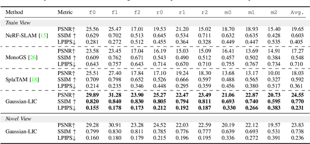
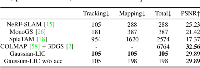
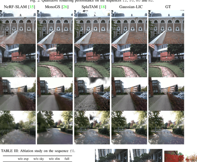
Abstract:We present a real-time LiDAR-Inertial-Camera SLAM system with 3D Gaussian Splatting as the mapping backend. Leveraging robust pose estimates from our LiDAR-Inertial-Camera odometry, Coco-LIC, an incremental photo-realistic mapping system is proposed in this paper. We initialize 3D Gaussians from colorized LiDAR points and optimize them using differentiable rendering powered by 3D Gaussian Splatting. Meticulously designed strategies are employed to incrementally expand the Gaussian map and adaptively control its density, ensuring high-quality mapping with real-time capability. Experiments conducted in diverse scenarios demonstrate the superior performance of our method compared to existing radiance-field-based SLAM systems.
SC-Diff: 3D Shape Completion with Latent Diffusion Models
Mar 19, 2024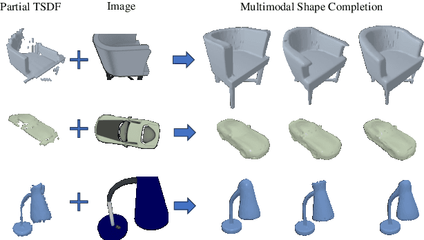
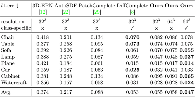
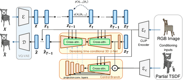
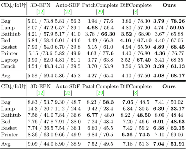
Abstract:This paper introduces a 3D shape completion approach using a 3D latent diffusion model optimized for completing shapes, represented as Truncated Signed Distance Functions (TSDFs), from partial 3D scans. Our method combines image-based conditioning through cross-attention and spatial conditioning through the integration of 3D features from captured partial scans. This dual guidance enables high-fidelity, realistic shape completions at superior resolutions. At the core of our approach is the compression of 3D data into a low-dimensional latent space using an auto-encoder inspired by 2D latent diffusion models. This compression facilitates the processing of higher-resolution shapes and allows us to apply our model across multiple object classes, a significant improvement over other existing diffusion-based shape completion methods, which often require a separate diffusion model for each class. We validated our approach against two common benchmarks in the field of shape completion, demonstrating competitive performance in terms of accuracy and realism and performing on par with state-of-the-art methods despite operating at a higher resolution with a single model for all object classes. We present a comprehensive evaluation of our model, showcasing its efficacy in handling diverse shape completion challenges, even on unseen object classes. The code will be released upon acceptance.
CART: Caltech Aerial RGB-Thermal Dataset in the Wild
Mar 13, 2024
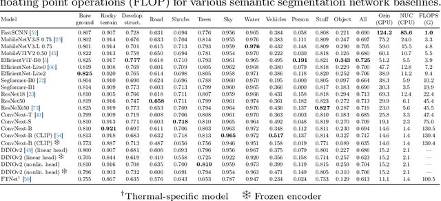
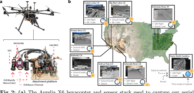

Abstract:We present the first publicly available RGB-thermal dataset designed for aerial robotics operating in natural environments. Our dataset captures a variety of terrains across the continental United States, including rivers, lakes, coastlines, deserts, and forests, and consists of synchronized RGB, long-wave thermal, global positioning, and inertial data. Furthermore, we provide semantic segmentation annotations for 10 classes commonly encountered in natural settings in order to facilitate the development of perception algorithms robust to adverse weather and nighttime conditions. Using this dataset, we propose new and challenging benchmarks for thermal and RGB-thermal semantic segmentation, RGB-to-thermal image translation, and visual-inertial odometry. We present extensive results using state-of-the-art methods and highlight the challenges posed by temporal and geographical domain shifts in our data. Dataset and accompanying code will be provided at https://github.com/aerorobotics/caltech-aerial-rgbt-dataset
RIDERS: Radar-Infrared Depth Estimation for Robust Sensing
Feb 03, 2024Abstract:Dense depth recovery is crucial in autonomous driving, serving as a foundational element for obstacle avoidance, 3D object detection, and local path planning. Adverse weather conditions, including haze, dust, rain, snow, and darkness, introduce significant challenges to accurate dense depth estimation, thereby posing substantial safety risks in autonomous driving. These challenges are particularly pronounced for traditional depth estimation methods that rely on short electromagnetic wave sensors, such as visible spectrum cameras and near-infrared LiDAR, due to their susceptibility to diffraction noise and occlusion in such environments. To fundamentally overcome this issue, we present a novel approach for robust metric depth estimation by fusing a millimeter-wave Radar and a monocular infrared thermal camera, which are capable of penetrating atmospheric particles and unaffected by lighting conditions. Our proposed Radar-Infrared fusion method achieves highly accurate and finely detailed dense depth estimation through three stages, including monocular depth prediction with global scale alignment, quasi-dense Radar augmentation by learning Radar-pixels correspondences, and local scale refinement of dense depth using a scale map learner. Our method achieves exceptional visual quality and accurate metric estimation by addressing the challenges of ambiguity and misalignment that arise from directly fusing multi-modal long-wave features. We evaluate the performance of our approach on the NTU4DRadLM dataset and our self-collected challenging ZJU-Multispectrum dataset. Especially noteworthy is the unprecedented robustness demonstrated by our proposed method in smoky scenarios. Our code will be released at \url{https://github.com/MMOCKING/RIDERS}.
M2-CLIP: A Multimodal, Multi-task Adapting Framework for Video Action Recognition
Jan 22, 2024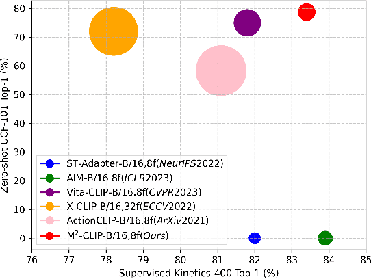
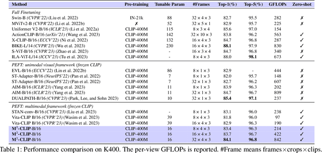

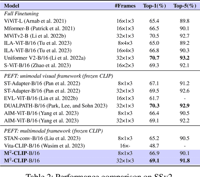
Abstract:Recently, the rise of large-scale vision-language pretrained models like CLIP, coupled with the technology of Parameter-Efficient FineTuning (PEFT), has captured substantial attraction in video action recognition. Nevertheless, prevailing approaches tend to prioritize strong supervised performance at the expense of compromising the models' generalization capabilities during transfer. In this paper, we introduce a novel Multimodal, Multi-task CLIP adapting framework named \name to address these challenges, preserving both high supervised performance and robust transferability. Firstly, to enhance the individual modality architectures, we introduce multimodal adapters to both the visual and text branches. Specifically, we design a novel visual TED-Adapter, that performs global Temporal Enhancement and local temporal Difference modeling to improve the temporal representation capabilities of the visual encoder. Moreover, we adopt text encoder adapters to strengthen the learning of semantic label information. Secondly, we design a multi-task decoder with a rich set of supervisory signals to adeptly satisfy the need for strong supervised performance and generalization within a multimodal framework. Experimental results validate the efficacy of our approach, demonstrating exceptional performance in supervised learning while maintaining strong generalization in zero-shot scenarios.
RadarCam-Depth: Radar-Camera Fusion for Depth Estimation with Learned Metric Scale
Jan 09, 2024Abstract:We present a novel approach for metric dense depth estimation based on the fusion of a single-view image and a sparse, noisy Radar point cloud. The direct fusion of heterogeneous Radar and image data, or their encodings, tends to yield dense depth maps with significant artifacts, blurred boundaries, and suboptimal accuracy. To circumvent this issue, we learn to augment versatile and robust monocular depth prediction with the dense metric scale induced from sparse and noisy Radar data. We propose a Radar-Camera framework for highly accurate and fine-detailed dense depth estimation with four stages, including monocular depth prediction, global scale alignment of monocular depth with sparse Radar points, quasi-dense scale estimation through learning the association between Radar points and image patches, and local scale refinement of dense depth using a scale map learner. Our proposed method significantly outperforms the state-of-the-art Radar-Camera depth estimation methods by reducing the mean absolute error (MAE) of depth estimation by 25.6% and 40.2% on the challenging nuScenes dataset and our self-collected ZJU-4DRadarCam dataset, respectively.
 Add to Chrome
 Add to Firefox
 Add to Edge