Shenzhou Chen
CDI3D: Cross-guided Dense-view Interpolation for 3D Reconstruction
Mar 11, 2025Abstract:3D object reconstruction from single-view image is a fundamental task in computer vision with wide-ranging applications. Recent advancements in Large Reconstruction Models (LRMs) have shown great promise in leveraging multi-view images generated by 2D diffusion models to extract 3D content. However, challenges remain as 2D diffusion models often struggle to produce dense images with strong multi-view consistency, and LRMs tend to amplify these inconsistencies during the 3D reconstruction process. Addressing these issues is critical for achieving high-quality and efficient 3D reconstruction. In this paper, we present CDI3D, a feed-forward framework designed for efficient, high-quality image-to-3D generation with view interpolation. To tackle the aforementioned challenges, we propose to integrate 2D diffusion-based view interpolation into the LRM pipeline to enhance the quality and consistency of the generated mesh. Specifically, our approach introduces a Dense View Interpolation (DVI) module, which synthesizes interpolated images between main views generated by the 2D diffusion model, effectively densifying the input views with better multi-view consistency. We also design a tilt camera pose trajectory to capture views with different elevations and perspectives. Subsequently, we employ a tri-plane-based mesh reconstruction strategy to extract robust tokens from these interpolated and original views, enabling the generation of high-quality 3D meshes with superior texture and geometry. Extensive experiments demonstrate that our method significantly outperforms previous state-of-the-art approaches across various benchmarks, producing 3D content with enhanced texture fidelity and geometric accuracy.
Pandora3D: A Comprehensive Framework for High-Quality 3D Shape and Texture Generation
Feb 21, 2025Abstract:This report presents a comprehensive framework for generating high-quality 3D shapes and textures from diverse input prompts, including single images, multi-view images, and text descriptions. The framework consists of 3D shape generation and texture generation. (1). The 3D shape generation pipeline employs a Variational Autoencoder (VAE) to encode implicit 3D geometries into a latent space and a diffusion network to generate latents conditioned on input prompts, with modifications to enhance model capacity. An alternative Artist-Created Mesh (AM) generation approach is also explored, yielding promising results for simpler geometries. (2). Texture generation involves a multi-stage process starting with frontal images generation followed by multi-view images generation, RGB-to-PBR texture conversion, and high-resolution multi-view texture refinement. A consistency scheduler is plugged into every stage, to enforce pixel-wise consistency among multi-view textures during inference, ensuring seamless integration. The pipeline demonstrates effective handling of diverse input formats, leveraging advanced neural architectures and novel methodologies to produce high-quality 3D content. This report details the system architecture, experimental results, and potential future directions to improve and expand the framework. The source code and pretrained weights are released at: https://github.com/Tencent/Tencent-XR-3DGen.
MARS: Mesh AutoRegressive Model for 3D Shape Detailization
Feb 17, 2025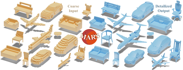

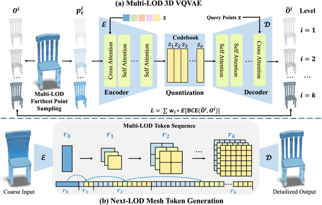

Abstract:State-of-the-art methods for mesh detailization predominantly utilize Generative Adversarial Networks (GANs) to generate detailed meshes from coarse ones. These methods typically learn a specific style code for each category or similar categories without enforcing geometry supervision across different Levels of Detail (LODs). Consequently, such methods often fail to generalize across a broader range of categories and cannot ensure shape consistency throughout the detailization process. In this paper, we introduce MARS, a novel approach for 3D shape detailization. Our method capitalizes on a novel multi-LOD, multi-category mesh representation to learn shape-consistent mesh representations in latent space across different LODs. We further propose a mesh autoregressive model capable of generating such latent representations through next-LOD token prediction. This approach significantly enhances the realism of the generated shapes. Extensive experiments conducted on the challenging 3D Shape Detailization benchmark demonstrate that our proposed MARS model achieves state-of-the-art performance, surpassing existing methods in both qualitative and quantitative assessments. Notably, the model's capability to generate fine-grained details while preserving the overall shape integrity is particularly commendable.
LAM3D: Large Image-Point-Cloud Alignment Model for 3D Reconstruction from Single Image
May 24, 2024
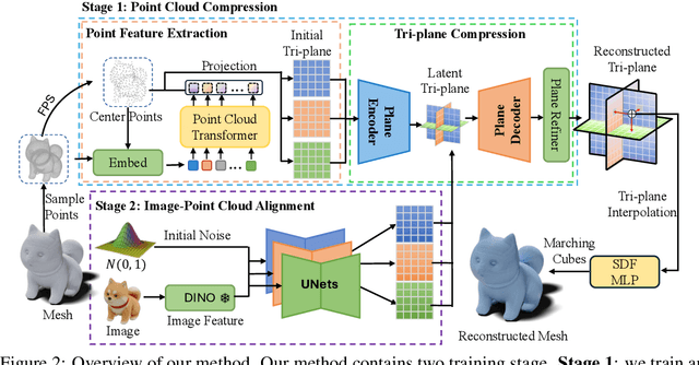
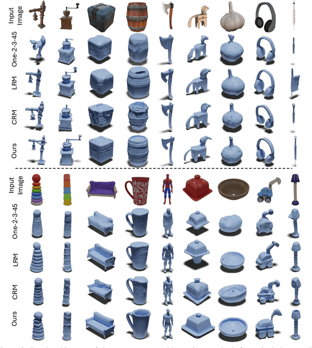

Abstract:Large Reconstruction Models have made significant strides in the realm of automated 3D content generation from single or multiple input images. Despite their success, these models often produce 3D meshes with geometric inaccuracies, stemming from the inherent challenges of deducing 3D shapes solely from image data. In this work, we introduce a novel framework, the Large Image and Point Cloud Alignment Model (LAM3D), which utilizes 3D point cloud data to enhance the fidelity of generated 3D meshes. Our methodology begins with the development of a point-cloud-based network that effectively generates precise and meaningful latent tri-planes, laying the groundwork for accurate 3D mesh reconstruction. Building upon this, our Image-Point-Cloud Feature Alignment technique processes a single input image, aligning to the latent tri-planes to imbue image features with robust 3D information. This process not only enriches the image features but also facilitates the production of high-fidelity 3D meshes without the need for multi-view input, significantly reducing geometric distortions. Our approach achieves state-of-the-art high-fidelity 3D mesh reconstruction from a single image in just 6 seconds, and experiments on various datasets demonstrate its effectiveness.
NeuSDFusion: A Spatial-Aware Generative Model for 3D Shape Completion, Reconstruction, and Generation
Mar 27, 2024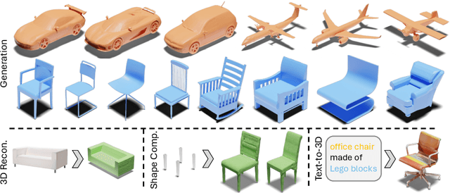
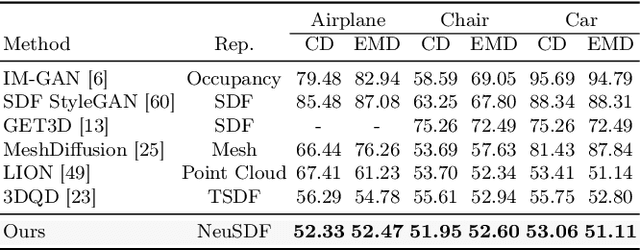

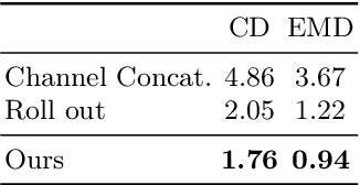
Abstract:3D shape generation aims to produce innovative 3D content adhering to specific conditions and constraints. Existing methods often decompose 3D shapes into a sequence of localized components, treating each element in isolation without considering spatial consistency. As a result, these approaches exhibit limited versatility in 3D data representation and shape generation, hindering their ability to generate highly diverse 3D shapes that comply with the specified constraints. In this paper, we introduce a novel spatial-aware 3D shape generation framework that leverages 2D plane representations for enhanced 3D shape modeling. To ensure spatial coherence and reduce memory usage, we incorporate a hybrid shape representation technique that directly learns a continuous signed distance field representation of the 3D shape using orthogonal 2D planes. Additionally, we meticulously enforce spatial correspondences across distinct planes using a transformer-based autoencoder structure, promoting the preservation of spatial relationships in the generated 3D shapes. This yields an algorithm that consistently outperforms state-of-the-art 3D shape generation methods on various tasks, including unconditional shape generation, multi-modal shape completion, single-view reconstruction, and text-to-shape synthesis.
Frankenstein: Generating Semantic-Compositional 3D Scenes in One Tri-Plane
Mar 24, 2024


Abstract:We present Frankenstein, a diffusion-based framework that can generate semantic-compositional 3D scenes in a single pass. Unlike existing methods that output a single, unified 3D shape, Frankenstein simultaneously generates multiple separated shapes, each corresponding to a semantically meaningful part. The 3D scene information is encoded in one single tri-plane tensor, from which multiple Singed Distance Function (SDF) fields can be decoded to represent the compositional shapes. During training, an auto-encoder compresses tri-planes into a latent space, and then the denoising diffusion process is employed to approximate the distribution of the compositional scenes. Frankenstein demonstrates promising results in generating room interiors as well as human avatars with automatically separated parts. The generated scenes facilitate many downstream applications, such as part-wise re-texturing, object rearrangement in the room or avatar cloth re-targeting.
Compact 3D Map-Based Monocular Localization Using Semantic Edge Alignment
Mar 27, 2021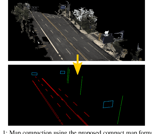
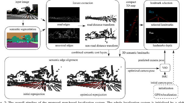
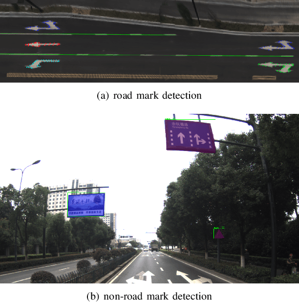
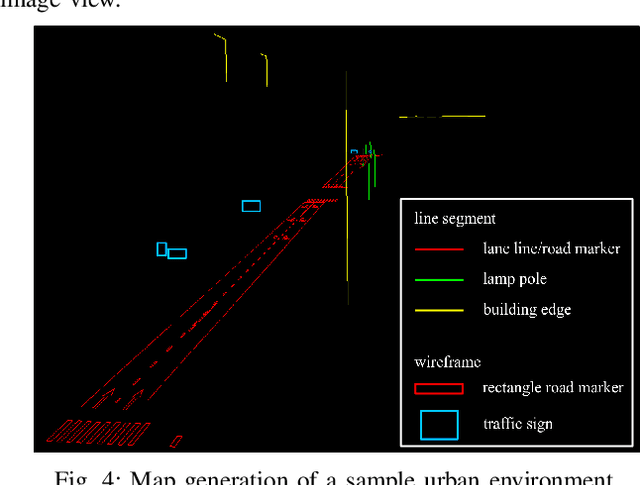
Abstract:Accurate localization is fundamental to a variety of applications, such as navigation, robotics, autonomous driving, and Augmented Reality (AR). Different from incremental localization, global localization has no drift caused by error accumulation, which is desired in many application scenarios. In addition to GPS used in the open air, 3D maps are also widely used as alternative global localization references. In this paper, we propose a compact 3D map-based global localization system using a low-cost monocular camera and an IMU (Inertial Measurement Unit). The proposed compact map consists of two types of simplified elements with multiple semantic labels, which is well adaptive to various man-made environments like urban environments. Also, semantic edge features are used for the key image-map registration, which is robust against occlusion and long-term appearance changes in the environments. To further improve the localization performance, the key semantic edge alignment is formulated as an optimization problem based on initial poses predicted by an independent VIO (Visual-Inertial Odometry) module. The localization system is realized with modular design in real time. We evaluate the localization accuracy through real-world experimental results compared with ground truth, long-term localization performance is also demonstrated.
A Dataset for Evaluating Multi-spectral Motion Estimation Methods
Jul 01, 2020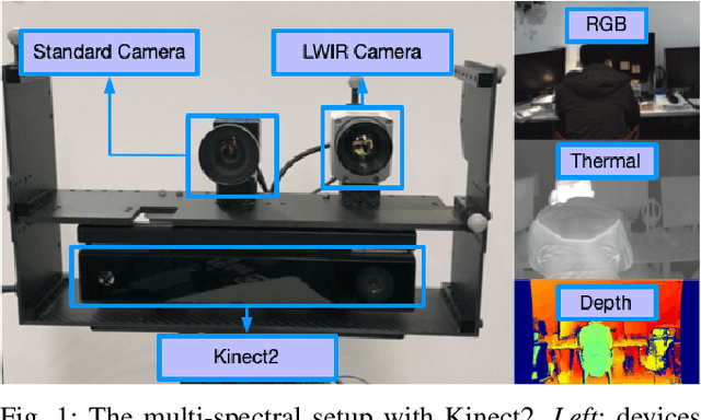
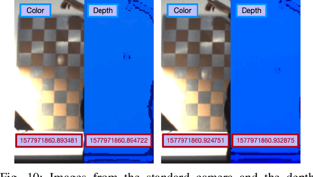
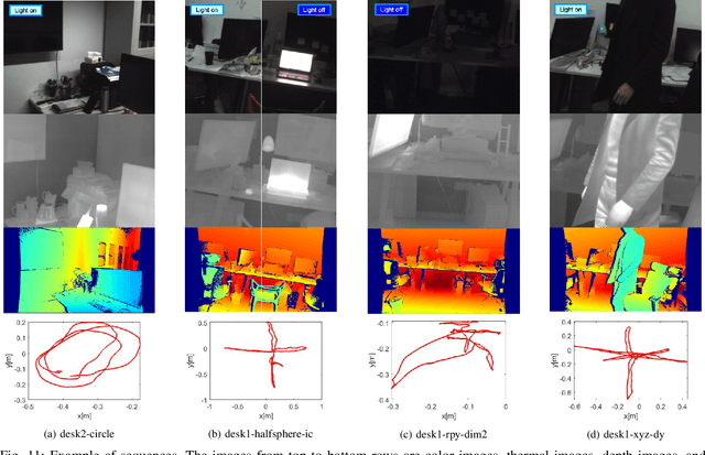

Abstract:Visible images have been widely used for indoor motion estimation. Thermal images, in contrast, are more challenging to be used in motion estimation since they typically have lower resolution, less texture, and more noise. In this paper, a novel dataset for evaluating the performance of multi-spectral motion estimation systems is presented. The dataset includes both multi-spectral and dense depth images with accurate ground-truth camera poses provided by a motion capture system. All the sequences are recorded from a handheld multi-spectral device, which consists of a standard visible-light camera, a long-wave infrared camera, and a depth camera. The multi-spectral images, including both color and thermal images in full sensor resolution (640 $\times$ 480), are obtained from the hardware-synchronized standard and long-wave infrared camera at 32Hz. The depth images are captured by a Microsoft Kinect2 and can have benefits for learning cross-modalities stereo matching. In addition to the sequences with bright illumination, the dataset also contains scenes with dim or varying illumination. The full dataset, including both raw data and calibration data with detailed specifications of data format, is publicly available.
 Add to Chrome
 Add to Firefox
 Add to Edge