Charlotte Pelletier
OBELIX, IRISA
On the use of Graphs for Satellite Image Time Series
May 22, 2025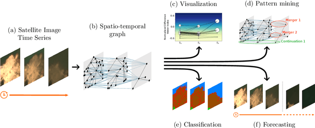

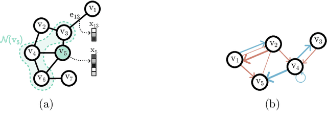
Abstract:The Earth's surface is subject to complex and dynamic processes, ranging from large-scale phenomena such as tectonic plate movements to localized changes associated with ecosystems, agriculture, or human activity. Satellite images enable global monitoring of these processes with extensive spatial and temporal coverage, offering advantages over in-situ methods. In particular, resulting satellite image time series (SITS) datasets contain valuable information. To handle their large volume and complexity, some recent works focus on the use of graph-based techniques that abandon the regular Euclidean structure of satellite data to work at an object level. Besides, graphs enable modelling spatial and temporal interactions between identified objects, which are crucial for pattern detection, classification and regression tasks. This paper is an effort to examine the integration of graph-based methods in spatio-temporal remote-sensing analysis. In particular, it aims to present a versatile graph-based pipeline to tackle SITS analysis. It focuses on the construction of spatio-temporal graphs from SITS and their application to downstream tasks. The paper includes a comprehensive review and two case studies, which highlight the potential of graph-based approaches for land cover mapping and water resource forecasting. It also discusses numerous perspectives to resolve current limitations and encourage future developments.
MONSTER: Monash Scalable Time Series Evaluation Repository
Feb 21, 2025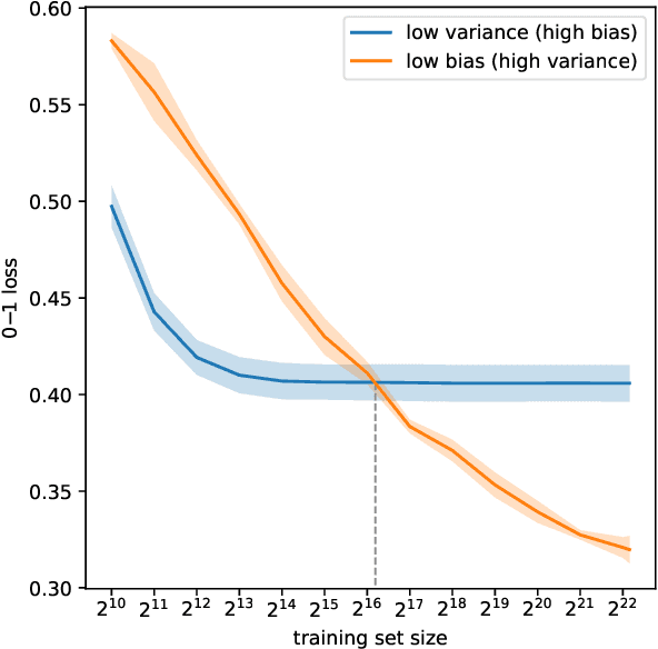
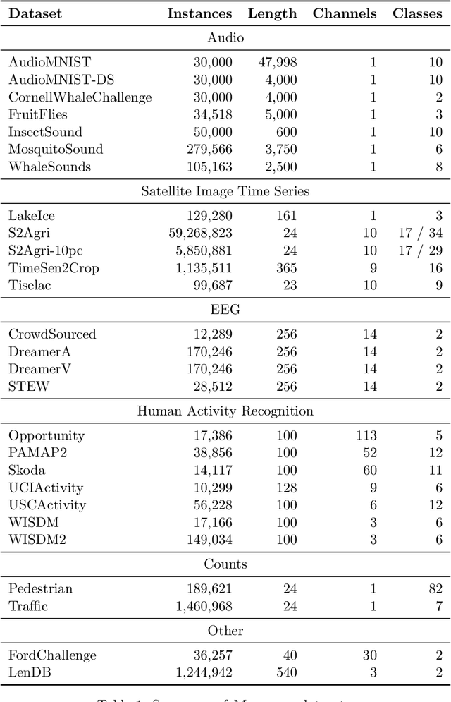
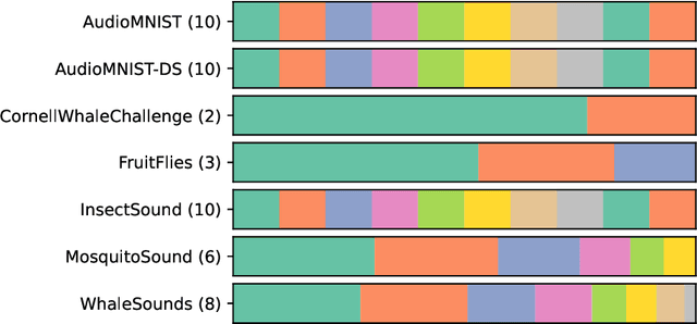
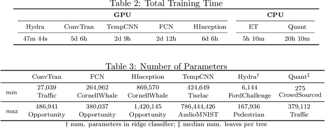
Abstract:We introduce MONSTER-the MONash Scalable Time Series Evaluation Repository-a collection of large datasets for time series classification. The field of time series classification has benefitted from common benchmarks set by the UCR and UEA time series classification repositories. However, the datasets in these benchmarks are small, with median sizes of 217 and 255 examples, respectively. In consequence they favour a narrow subspace of models that are optimised to achieve low classification error on a wide variety of smaller datasets, that is, models that minimise variance, and give little weight to computational issues such as scalability. Our hope is to diversify the field by introducing benchmarks using larger datasets. We believe that there is enormous potential for new progress in the field by engaging with the theoretical and practical challenges of learning effectively from larger quantities of data.
Cross-sensor super-resolution of irregularly sampled Sentinel-2 time series
Apr 25, 2024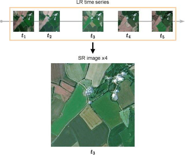

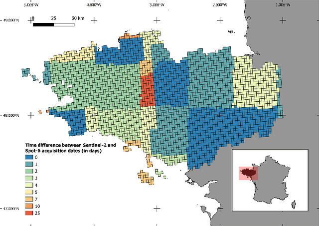

Abstract:Satellite imaging generally presents a trade-off between the frequency of acquisitions and the spatial resolution of the images. Super-resolution is often advanced as a way to get the best of both worlds. In this work, we investigate multi-image super-resolution of satellite image time series, i.e. how multiple images of the same area acquired at different dates can help reconstruct a higher resolution observation. In particular, we extend state-of-the-art deep single and multi-image super-resolution algorithms, such as SRDiff and HighRes-net, to deal with irregularly sampled Sentinel-2 time series. We introduce BreizhSR, a new dataset for 4x super-resolution of Sentinel-2 time series using very high-resolution SPOT-6 imagery of Brittany, a French region. We show that using multiple images significantly improves super-resolution performance, and that a well-designed temporal positional encoding allows us to perform super-resolution for different times of the series. In addition, we observe a trade-off between spectral fidelity and perceptual quality of the reconstructed HR images, questioning future directions for super-resolution of Earth Observation data.
Deep Learning for Satellite Image Time Series Analysis: A Review
Apr 11, 2024Abstract:Earth observation (EO) satellite missions have been providing detailed images about the state of the Earth and its land cover for over 50 years. Long term missions, such as NASA's Landsat, Terra, and Aqua satellites, and more recently, the ESA's Sentinel missions, record images of the entire world every few days. Although single images provide point-in-time data, repeated images of the same area, or satellite image time series (SITS) provide information about the changing state of vegetation and land use. These SITS are useful for modeling dynamic processes and seasonal changes such as plant phenology. They have potential benefits for many aspects of land and natural resource management, including applications in agricultural, forest, water, and disaster management, urban planning, and mining. However, the resulting satellite image time series (SITS) are complex, incorporating information from the temporal, spatial, and spectral dimensions. Therefore, deep learning methods are often deployed as they can analyze these complex relationships. This review presents a summary of the state-of-the-art methods of modelling environmental, agricultural, and other Earth observation variables from SITS data using deep learning methods. We aim to provide a resource for remote sensing experts interested in using deep learning techniques to enhance Earth observation models with temporal information.
Match-And-Deform: Time Series Domain Adaptation through Optimal Transport and Temporal Alignment
Aug 25, 2023


Abstract:While large volumes of unlabeled data are usually available, associated labels are often scarce. The unsupervised domain adaptation problem aims at exploiting labels from a source domain to classify data from a related, yet different, target domain. When time series are at stake, new difficulties arise as temporal shifts may appear in addition to the standard feature distribution shift. In this paper, we introduce the Match-And-Deform (MAD) approach that aims at finding correspondences between the source and target time series while allowing temporal distortions. The associated optimization problem simultaneously aligns the series thanks to an optimal transport loss and the time stamps through dynamic time warping. When embedded into a deep neural network, MAD helps learning new representations of time series that both align the domains and maximize the discriminative power of the network. Empirical studies on benchmark datasets and remote sensing data demonstrate that MAD makes meaningful sample-to-sample pairing and time shift estimation, reaching similar or better classification performance than state-of-the-art deep time series domain adaptation strategies.
Generalized Classification of Satellite Image Time Series with Thermal Positional Encoding
Mar 17, 2022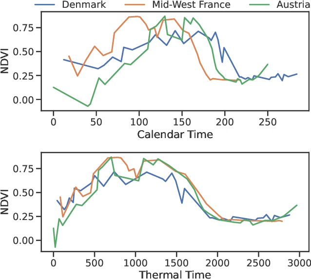
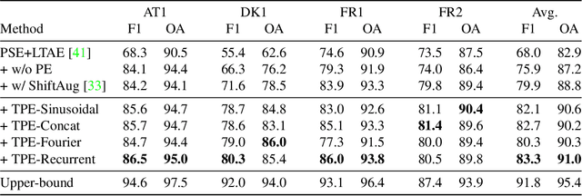
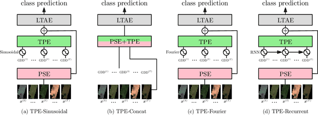
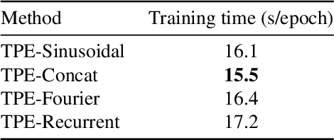
Abstract:Large-scale crop type classification is a task at the core of remote sensing efforts with applications of both economic and ecological importance. Current state-of-the-art deep learning methods are based on self-attention and use satellite image time series (SITS) to discriminate crop types based on their unique growth patterns. However, existing methods generalize poorly to regions not seen during training mainly due to not being robust to temporal shifts of the growing season caused by variations in climate. To this end, we propose Thermal Positional Encoding (TPE) for attention-based crop classifiers. Unlike previous positional encoding based on calendar time (e.g. day-of-year), TPE is based on thermal time, which is obtained by accumulating daily average temperatures over the growing season. Since crop growth is directly related to thermal time, but not calendar time, TPE addresses the temporal shifts between different regions to improve generalization. We propose multiple TPE strategies, including learnable methods, to further improve results compared to the common fixed positional encodings. We demonstrate our approach on a crop classification task across four different European regions, where we obtain state-of-the-art generalization results.
TimeMatch: Unsupervised Cross-Region Adaptation by Temporal Shift Estimation
Nov 04, 2021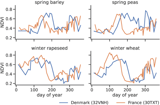

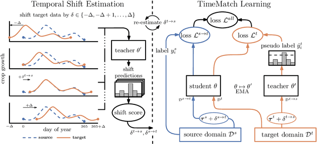
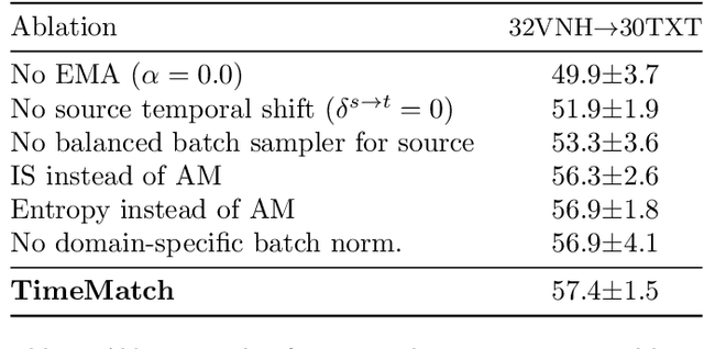
Abstract:The recent developments of deep learning models that capture the complex temporal patterns of crop phenology have greatly advanced crop classification of Satellite Image Time Series (SITS). However, when applied to target regions spatially different from the training region, these models perform poorly without any target labels due to the temporal shift of crop phenology between regions. To address this unsupervised cross-region adaptation setting, existing methods learn domain-invariant features without any target supervision, but not the temporal shift itself. As a consequence, these techniques provide only limited benefits for SITS. In this paper, we propose TimeMatch, a new unsupervised domain adaptation method for SITS that directly accounts for the temporal shift. TimeMatch consists of two components: 1) temporal shift estimation, which estimates the temporal shift of the unlabeled target region with a source-trained model, and 2) TimeMatch learning, which combines temporal shift estimation with semi-supervised learning to adapt a classifier to an unlabeled target region. We also introduce an open-access dataset for cross-region adaptation with SITS from four different regions in Europe. On this dataset, we demonstrate that TimeMatch outperforms all competing methods by 11% in F1-score across five different adaptation scenarios, setting a new state-of-the-art for cross-region adaptation.
Elastic Similarity Measures for Multivariate Time Series Classification
Feb 20, 2021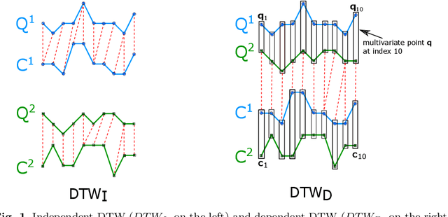
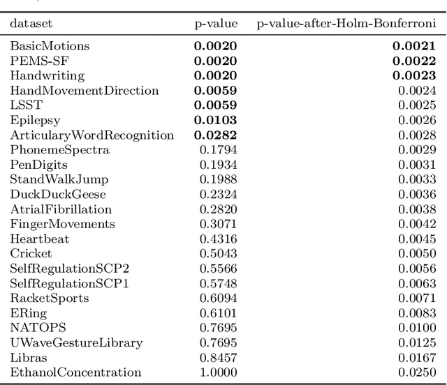
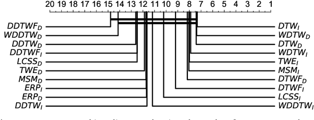
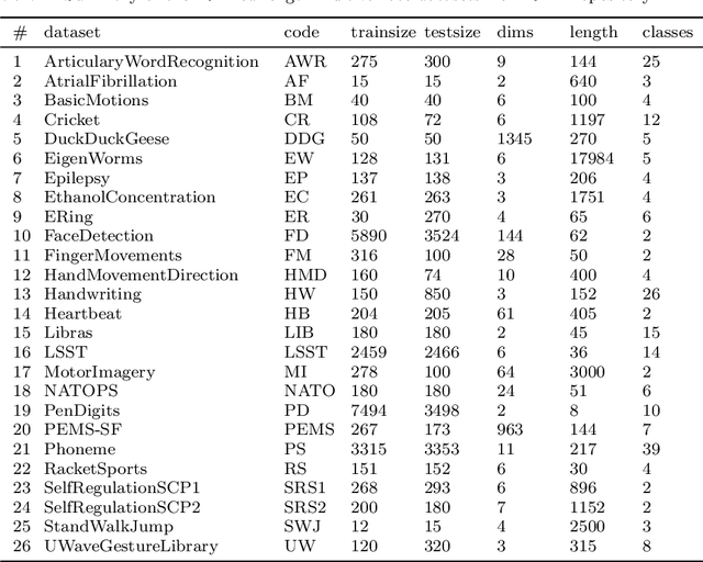
Abstract:Elastic similarity measures are a class of similarity measures specifically designed to work with time series data. When scoring the similarity between two time series, they allow points that do not correspond in timestamps to be aligned. This can compensate for misalignments in the time axis of time series data, and for similar processes that proceed at variable and differing paces. Elastic similarity measures are widely used in machine learning tasks such as classification, clustering and outlier detection when using time series data. There is a multitude of research on various univariate elastic similarity measures. However, except for multivariate versions of the well known Dynamic Time Warping (DTW) there is a lack of work to generalise other similarity measures for multivariate cases. This paper adapts two existing strategies used in multivariate DTW, namely, Independent and Dependent DTW, to several commonly used elastic similarity measures. Using 23 datasets from the University of East Anglia (UEA) multivariate archive, for nearest neighbour classification, we demonstrate that each measure outperforms all others on at least one dataset and that there are datasets for which either the dependent versions of all measures are more accurate than their independent counterparts or vice versa. This latter finding suggests that these differences arise from a fundamental property of the data. We also show that an ensemble of such nearest neighbour classifiers is highly competitive with other state-of-the-art multivariate time series classifiers.
A Bayesian-inspired, deep learning, semi-supervised domain adaptation technique for land cover mapping
May 25, 2020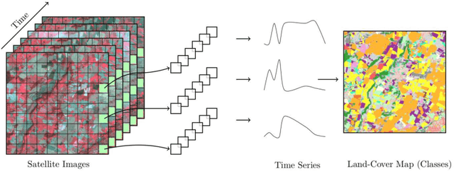
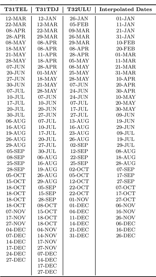
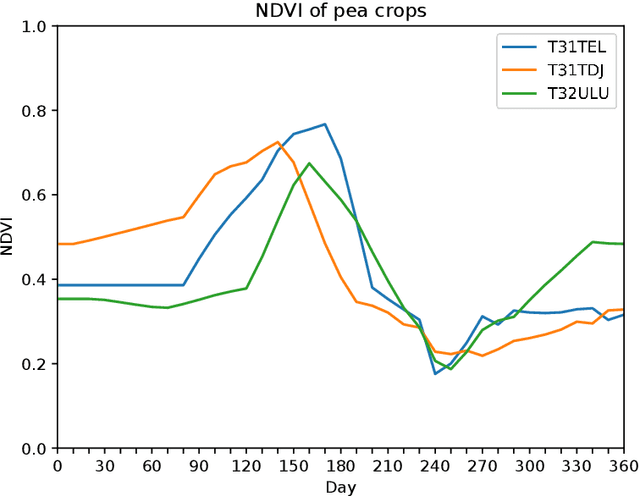

Abstract:Land cover maps are a vital input variable to many types of environmental research and management. While they can be produced automatically by machine learning techniques, these techniques require substantial training data to achieve high levels of accuracy, which are not always available. One technique researchers use when labelled training data are scarce is domain adaptation (DA) -- where data from an alternate region, known as the source domain, are used to train a classifier and this model is adapted to map the study region, or target domain. The scenario we address in this paper is known as semi-supervised DA, where some labelled samples are available in the target domain. In this paper we present Sourcerer, a Bayesian-inspired, deep learning-based, semi-supervised DA technique for producing land cover maps from SITS data. The technique takes a convolutional neural network trained on a source domain and then trains further on the available target domain with a novel regularizer applied to the model weights. The regularizer adjusts the degree to which the model is modified to fit the target data, limiting the degree of change when the target data are few in number and increasing it as target data quantity increases. Our experiments on Sentinel-2 time series images compare Sourcerer with two state-of-the-art semi-supervised domain adaptation techniques and four baseline models. We show that on two different source-target domain pairings Sourcerer outperforms all other methods for any quantity of labelled target data available. In fact, the results on the more difficult target domain show that the starting accuracy of Sourcerer (when no labelled target data are available), 74.2%, is greater than the next-best state-of-the-art method trained on 20,000 labelled target instances.
InceptionTime: Finding AlexNet for Time Series Classification
Sep 13, 2019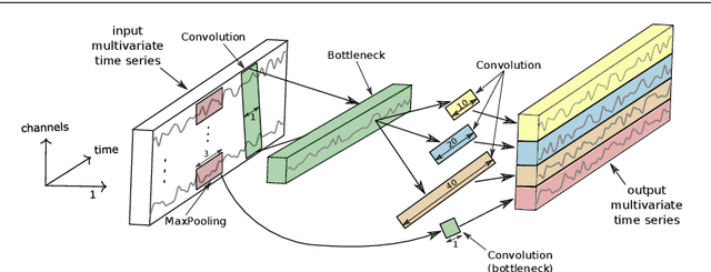
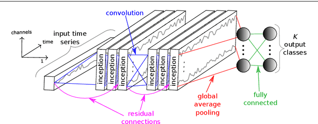
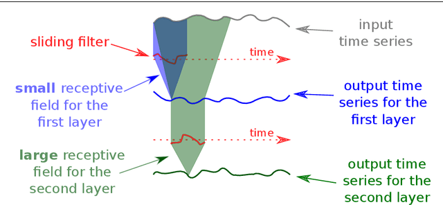
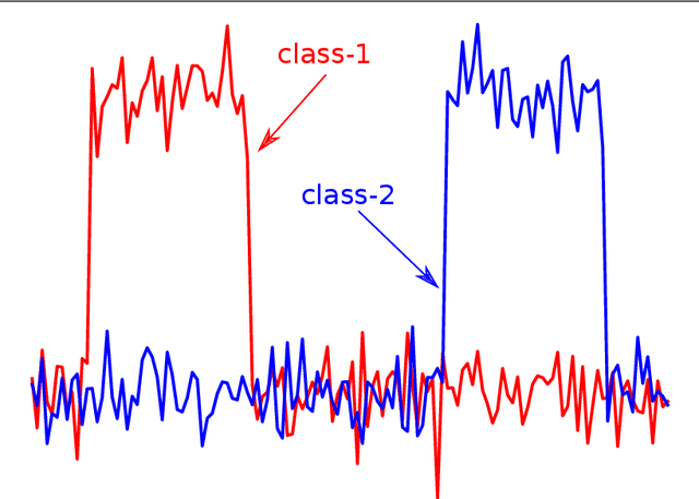
Abstract:Time series classification (TSC) is the area of machine learning interested in learning how to assign labels to time series. The last few decades of work in this area have led to significant progress in the accuracy of classifiers, with the state of the art now represented by the HIVE-COTE algorithm. While extremely accurate, HIVE-COTE is infeasible to use in many applications because of its very high training time complexity in O(N^2*T^4) for a dataset with N time series of length T. For example, it takes HIVE-COTE more than 72,000s to learn from a small dataset with N=700 time series of short length T=46. Deep learning, on the other hand, has now received enormous attention because of its high scalability and state-of-the-art accuracy in computer vision and natural language processing tasks. Deep learning for TSC has only very recently started to be explored, with the first few architectures developed over the last 3 years only. The accuracy of deep learning for TSC has been raised to a competitive level, but has not quite reached the level of HIVE-COTE. This is what this paper achieves: outperforming HIVE-COTE's accuracy together with scalability. We take an important step towards finding the AlexNet network for TSC by presenting InceptionTime---an ensemble of deep Convolutional Neural Network (CNN) models, inspired by the Inception-v4 architecture. Our experiments show that InceptionTime slightly outperforms HIVE-COTE with a win/draw/loss on the UCR archive of 40/6/39. Not only is InceptionTime more accurate, but it is much faster: InceptionTime learns from that same dataset with 700 time series in 2,300s but can also learn from a dataset with 8M time series in 13 hours, a quantity of data that is fully out of reach of HIVE-COTE.
 Add to Chrome
 Add to Firefox
 Add to Edge