A Bayesian-inspired, deep learning, semi-supervised domain adaptation technique for land cover mapping
Paper and Code
May 25, 2020


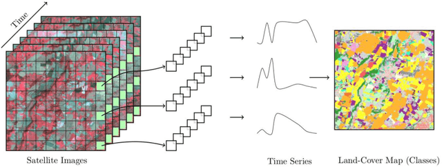
Land cover maps are a vital input variable to many types of environmental research and management. While they can be produced automatically by machine learning techniques, these techniques require substantial training data to achieve high levels of accuracy, which are not always available. One technique researchers use when labelled training data are scarce is domain adaptation (DA) -- where data from an alternate region, known as the source domain, are used to train a classifier and this model is adapted to map the study region, or target domain. The scenario we address in this paper is known as semi-supervised DA, where some labelled samples are available in the target domain. In this paper we present Sourcerer, a Bayesian-inspired, deep learning-based, semi-supervised DA technique for producing land cover maps from SITS data. The technique takes a convolutional neural network trained on a source domain and then trains further on the available target domain with a novel regularizer applied to the model weights. The regularizer adjusts the degree to which the model is modified to fit the target data, limiting the degree of change when the target data are few in number and increasing it as target data quantity increases. Our experiments on Sentinel-2 time series images compare Sourcerer with two state-of-the-art semi-supervised domain adaptation techniques and four baseline models. We show that on two different source-target domain pairings Sourcerer outperforms all other methods for any quantity of labelled target data available. In fact, the results on the more difficult target domain show that the starting accuracy of Sourcerer (when no labelled target data are available), 74.2%, is greater than the next-best state-of-the-art method trained on 20,000 labelled target instances.
 Add to Chrome
 Add to Firefox
 Add to Edge