Björn Lütjens
MeltwaterBench: Deep learning for spatiotemporal downscaling of surface meltwater
Dec 13, 2025


Abstract:The Greenland ice sheet is melting at an accelerated rate due to processes that are not fully understood and hard to measure. The distribution of surface meltwater can help understand these processes and is observable through remote sensing, but current maps of meltwater face a trade-off: They are either high-resolution in time or space, but not both. We develop a deep learning model that creates gridded surface meltwater maps at daily 100m resolution by fusing data streams from remote sensing observations and physics-based models. In particular, we spatiotemporally downscale regional climate model (RCM) outputs using synthetic aperture radar (SAR), passive microwave (PMW), and a digital elevation model (DEM) over the Helheim Glacier in Eastern Greenland from 2017-2023. Using SAR-derived meltwater as "ground truth", we show that a deep learning-based method that fuses all data streams is over 10 percentage points more accurate over our study area than existing non deep learning-based approaches that only rely on a regional climate model (83% vs. 95% Acc.) or passive microwave observations (72% vs. 95% Acc.). Alternatively, creating a gridded product through a running window calculation with SAR data underestimates extreme melt events, but also achieves notable accuracy (90%) and does not rely on deep learning. We evaluate standard deep learning methods (UNet and DeepLabv3+), and publish our spatiotemporally aligned dataset as a benchmark, MeltwaterBench, for intercomparisons with more complex data-driven downscaling methods. The code and data are available at $\href{https://github.com/blutjens/hrmelt}{github.com/blutjens/hrmelt}$.
The impact of internal variability on benchmarking deep learning climate emulators
Aug 09, 2024

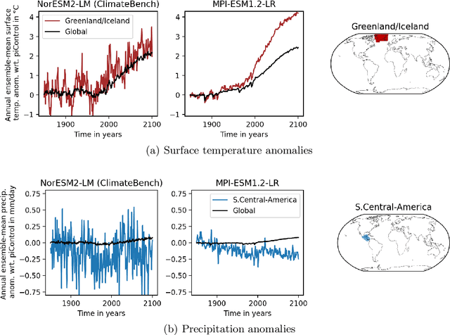

Abstract:Full-complexity Earth system models (ESMs) are computationally very expensive, limiting their use in exploring the climate outcomes of multiple emission pathways. More efficient emulators that approximate ESMs can directly map emissions onto climate outcomes, and benchmarks are being used to evaluate their accuracy on standardized tasks and datasets. We investigate a popular benchmark in data-driven climate emulation, ClimateBench, on which deep learning-based emulators are currently achieving the best performance. We implement a linear regression-based emulator, akin to pattern scaling, and find that it outperforms the incumbent 100M-parameter deep learning foundation model, ClimaX, on 3 out of 4 regionally-resolved surface-level climate variables. While emulating surface temperature is expected to be predominantly linear, this result is surprising for emulating precipitation. We identify that this outcome is a result of high levels of internal variability in the benchmark targets. To address internal variability, we update the benchmark targets with ensemble averages from the MPI-ESM1.2-LR model that contain 50 instead of 3 climate simulations per emission pathway. Using the new targets, we show that linear pattern scaling continues to be more accurate on temperature, but can be outperformed by a deep learning-based model for emulating precipitation. We publish our code, data, and an interactive tutorial at github.com/blutjens/climate-emulator.
ClimSim: An open large-scale dataset for training high-resolution physics emulators in hybrid multi-scale climate simulators
Jun 16, 2023Abstract:Modern climate projections lack adequate spatial and temporal resolution due to computational constraints. A consequence is inaccurate and imprecise prediction of critical processes such as storms. Hybrid methods that combine physics with machine learning (ML) have introduced a new generation of higher fidelity climate simulators that can sidestep Moore's Law by outsourcing compute-hungry, short, high-resolution simulations to ML emulators. However, this hybrid ML-physics simulation approach requires domain-specific treatment and has been inaccessible to ML experts because of lack of training data and relevant, easy-to-use workflows. We present ClimSim, the largest-ever dataset designed for hybrid ML-physics research. It comprises multi-scale climate simulations, developed by a consortium of climate scientists and ML researchers. It consists of 5.7 billion pairs of multivariate input and output vectors that isolate the influence of locally-nested, high-resolution, high-fidelity physics on a host climate simulator's macro-scale physical state. The dataset is global in coverage, spans multiple years at high sampling frequency, and is designed such that resulting emulators are compatible with downstream coupling into operational climate simulators. We implement a range of deterministic and stochastic regression baselines to highlight the ML challenges and their scoring. The data (https://huggingface.co/datasets/LEAP/ClimSim_high-res) and code (https://leap-stc.github.io/ClimSim) are released openly to support the development of hybrid ML-physics and high-fidelity climate simulations for the benefit of science and society.
GEO-Bench: Toward Foundation Models for Earth Monitoring
Jun 06, 2023
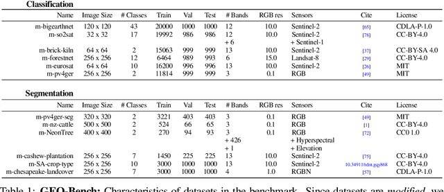
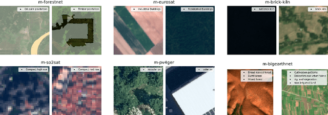
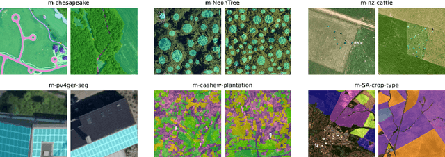
Abstract:Recent progress in self-supervision has shown that pre-training large neural networks on vast amounts of unsupervised data can lead to substantial increases in generalization to downstream tasks. Such models, recently coined foundation models, have been transformational to the field of natural language processing. Variants have also been proposed for image data, but their applicability to remote sensing tasks is limited. To stimulate the development of foundation models for Earth monitoring, we propose a benchmark comprised of six classification and six segmentation tasks, which were carefully curated and adapted to be both relevant to the field and well-suited for model evaluation. We accompany this benchmark with a robust methodology for evaluating models and reporting aggregated results to enable a reliable assessment of progress. Finally, we report results for 20 baselines to gain information about the performance of existing models. We believe that this benchmark will be a driver of progress across a variety of Earth monitoring tasks.
Teaching Computer Vision for Ecology
Jan 05, 2023


Abstract:Computer vision can accelerate ecology research by automating the analysis of raw imagery from sensors like camera traps, drones, and satellites. However, computer vision is an emerging discipline that is rarely taught to ecologists. This work discusses our experience teaching a diverse group of ecologists to prototype and evaluate computer vision systems in the context of an intensive hands-on summer workshop. We explain the workshop structure, discuss common challenges, and propose best practices. This document is intended for computer scientists who teach computer vision across disciplines, but it may also be useful to ecologists or other domain experts who are learning to use computer vision themselves.
Multiscale Neural Operator: Learning Fast and Grid-independent PDE Solvers
Jul 23, 2022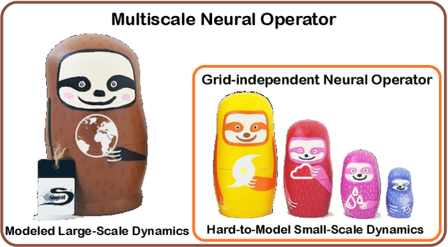

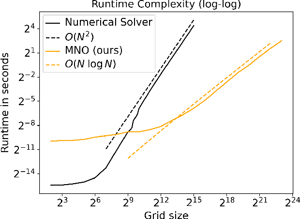
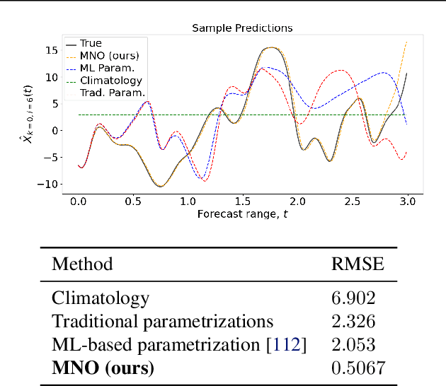
Abstract:Numerical simulations in climate, chemistry, or astrophysics are computationally too expensive for uncertainty quantification or parameter-exploration at high-resolution. Reduced-order or surrogate models are multiple orders of magnitude faster, but traditional surrogates are inflexible or inaccurate and pure machine learning (ML)-based surrogates too data-hungry. We propose a hybrid, flexible surrogate model that exploits known physics for simulating large-scale dynamics and limits learning to the hard-to-model term, which is called parametrization or closure and captures the effect of fine- onto large-scale dynamics. Leveraging neural operators, we are the first to learn grid-independent, non-local, and flexible parametrizations. Our \textit{multiscale neural operator} is motivated by a rich literature in multiscale modeling, has quasilinear runtime complexity, is more accurate or flexible than state-of-the-art parametrizations and demonstrated on the chaotic equation multiscale Lorenz96.
ReforesTree: A Dataset for Estimating Tropical Forest Carbon Stock with Deep Learning and Aerial Imagery
Jan 26, 2022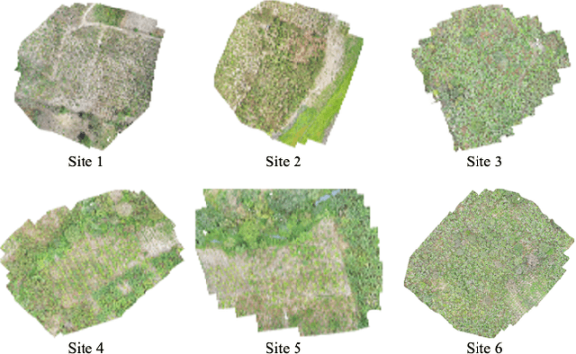
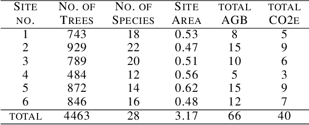
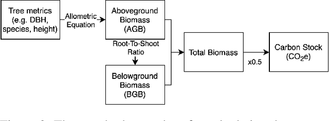
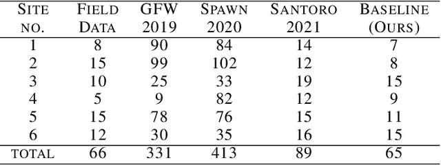
Abstract:Forest biomass is a key influence for future climate, and the world urgently needs highly scalable financing schemes, such as carbon offsetting certifications, to protect and restore forests. Current manual forest carbon stock inventory methods of measuring single trees by hand are time, labour, and cost-intensive and have been shown to be subjective. They can lead to substantial overestimation of the carbon stock and ultimately distrust in forest financing. The potential for impact and scale of leveraging advancements in machine learning and remote sensing technologies is promising but needs to be of high quality in order to replace the current forest stock protocols for certifications. In this paper, we present ReforesTree, a benchmark dataset of forest carbon stock in six agro-forestry carbon offsetting sites in Ecuador. Furthermore, we show that a deep learning-based end-to-end model using individual tree detection from low cost RGB-only drone imagery is accurately estimating forest carbon stock within official carbon offsetting certification standards. Additionally, our baseline CNN model outperforms state-of-the-art satellite-based forest biomass and carbon stock estimates for this type of small-scale, tropical agro-forestry sites. We present this dataset to encourage machine learning research in this area to increase accountability and transparency of monitoring, verification and reporting (MVR) in carbon offsetting projects, as well as scaling global reforestation financing through accurate remote sensing.
Toward Foundation Models for Earth Monitoring: Proposal for a Climate Change Benchmark
Dec 01, 2021
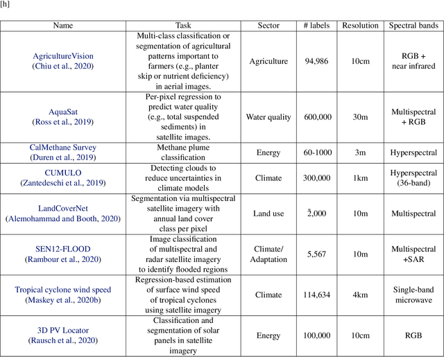
Abstract:Recent progress in self-supervision shows that pre-training large neural networks on vast amounts of unsupervised data can lead to impressive increases in generalisation for downstream tasks. Such models, recently coined as foundation models, have been transformational to the field of natural language processing. While similar models have also been trained on large corpuses of images, they are not well suited for remote sensing data. To stimulate the development of foundation models for Earth monitoring, we propose to develop a new benchmark comprised of a variety of downstream tasks related to climate change. We believe that this can lead to substantial improvements in many existing applications and facilitate the development of new applications. This proposal is also a call for collaboration with the aim of developing a better evaluation process to mitigate potential downsides of foundation models for Earth monitoring.
WiSoSuper: Benchmarking Super-Resolution Methods on Wind and Solar Data
Sep 23, 2021


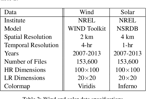
Abstract:The transition to green energy grids depends on detailed wind and solar forecasts to optimize the siting and scheduling of renewable energy generation. Operational forecasts from numerical weather prediction models, however, only have a spatial resolution of 10 to 20-km, which leads to sub-optimal usage and development of renewable energy farms. Weather scientists have been developing super-resolution methods to increase the resolution, but often rely on simple interpolation techniques or computationally expensive differential equation-based models. Recently, machine learning-based models, specifically the physics-informed resolution-enhancing generative adversarial network (PhIREGAN), have outperformed traditional downscaling methods. We provide a thorough and extensible benchmark of leading deep learning-based super-resolution techniques, including the enhanced super-resolution generative adversarial network (ESRGAN) and an enhanced deep super-resolution (EDSR) network, on wind and solar data. We accompany the benchmark with a novel public, processed, and machine learning-ready dataset for benchmarking super-resolution methods on wind and solar data.
Tackling the Overestimation of Forest Carbon with Deep Learning and Aerial Imagery
Aug 19, 2021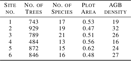
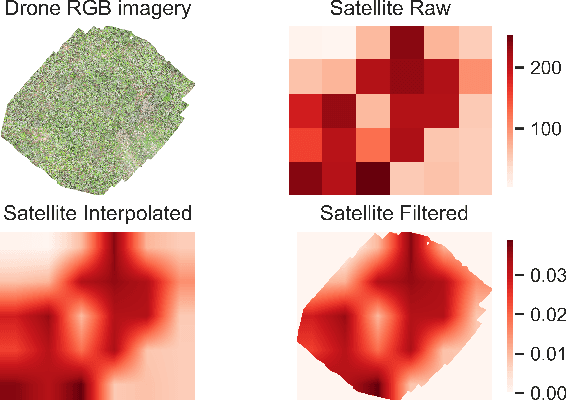
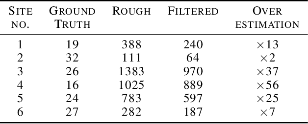
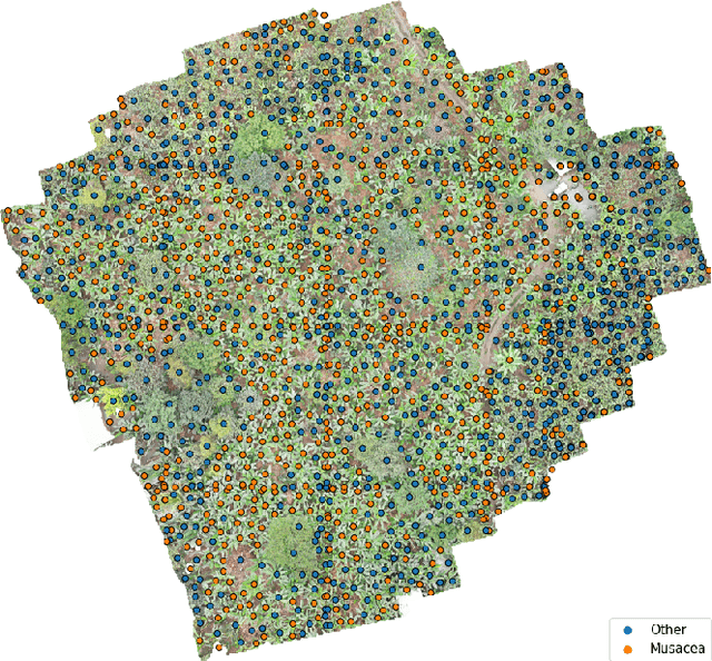
Abstract:Forest carbon offsets are increasingly popular and can play a significant role in financing climate mitigation, forest conservation, and reforestation. Measuring how much carbon is stored in forests is, however, still largely done via expensive, time-consuming, and sometimes unaccountable field measurements. To overcome these limitations, many verification bodies are leveraging machine learning (ML) algorithms to estimate forest carbon from satellite or aerial imagery. Aerial imagery allows for tree species or family classification, which improves the satellite imagery-based forest type classification. However, aerial imagery is significantly more expensive to collect and it is unclear by how much the higher resolution improves the forest carbon estimation. This proposal paper describes the first systematic comparison of forest carbon estimation from aerial imagery, satellite imagery, and ground-truth field measurements via deep learning-based algorithms for a tropical reforestation project. Our initial results show that forest carbon estimates from satellite imagery can overestimate above-ground biomass by up to 10-times for tropical reforestation projects. The significant difference between aerial and satellite-derived forest carbon measurements shows the potential for aerial imagery-based ML algorithms and raises the importance to extend this study to a global benchmark between options for carbon measurements.
 Add to Chrome
 Add to Firefox
 Add to Edge