Zhenjun Zhao
Neural Predictor-Corrector: Solving Homotopy Problems with Reinforcement Learning
Feb 03, 2026Abstract:The Homotopy paradigm, a general principle for solving challenging problems, appears across diverse domains such as robust optimization, global optimization, polynomial root-finding, and sampling. Practical solvers for these problems typically follow a predictor-corrector (PC) structure, but rely on hand-crafted heuristics for step sizes and iteration termination, which are often suboptimal and task-specific. To address this, we unify these problems under a single framework, which enables the design of a general neural solver. Building on this unified view, we propose Neural Predictor-Corrector (NPC), which replaces hand-crafted heuristics with automatically learned policies. NPC formulates policy selection as a sequential decision-making problem and leverages reinforcement learning to automatically discover efficient strategies. To further enhance generalization, we introduce an amortized training mechanism, enabling one-time offline training for a class of problems and efficient online inference on new instances. Experiments on four representative homotopy problems demonstrate that our method generalizes effectively to unseen instances. It consistently outperforms classical and specialized baselines in efficiency while demonstrating superior stability across tasks, highlighting the value of unifying homotopy methods into a single neural framework.
AdaGaR: Adaptive Gabor Representation for Dynamic Scene Reconstruction
Jan 02, 2026Abstract:Reconstructing dynamic 3D scenes from monocular videos requires simultaneously capturing high-frequency appearance details and temporally continuous motion. Existing methods using single Gaussian primitives are limited by their low-pass filtering nature, while standard Gabor functions introduce energy instability. Moreover, lack of temporal continuity constraints often leads to motion artifacts during interpolation. We propose AdaGaR, a unified framework addressing both frequency adaptivity and temporal continuity in explicit dynamic scene modeling. We introduce Adaptive Gabor Representation, extending Gaussians through learnable frequency weights and adaptive energy compensation to balance detail capture and stability. For temporal continuity, we employ Cubic Hermite Splines with Temporal Curvature Regularization to ensure smooth motion evolution. An Adaptive Initialization mechanism combining depth estimation, point tracking, and foreground masks establishes stable point cloud distributions in early training. Experiments on Tap-Vid DAVIS demonstrate state-of-the-art performance (PSNR 35.49, SSIM 0.9433, LPIPS 0.0723) and strong generalization across frame interpolation, depth consistency, video editing, and stereo view synthesis. Project page: https://jiewenchan.github.io/AdaGaR/
TurboReg: TurboClique for Robust and Efficient Point Cloud Registration
Jul 02, 2025


Abstract:Robust estimation is essential in correspondence-based Point Cloud Registration (PCR). Existing methods using maximal clique search in compatibility graphs achieve high recall but suffer from exponential time complexity, limiting their use in time-sensitive applications. To address this challenge, we propose a fast and robust estimator, TurboReg, built upon a novel lightweight clique, TurboClique, and a highly parallelizable Pivot-Guided Search (PGS) algorithm. First, we define the TurboClique as a 3-clique within a highly-constrained compatibility graph. The lightweight nature of the 3-clique allows for efficient parallel searching, and the highly-constrained compatibility graph ensures robust spatial consistency for stable transformation estimation. Next, PGS selects matching pairs with high SC$^2$ scores as pivots, effectively guiding the search toward TurboCliques with higher inlier ratios. Moreover, the PGS algorithm has linear time complexity and is significantly more efficient than the maximal clique search with exponential time complexity. Extensive experiments show that TurboReg achieves state-of-the-art performance across multiple real-world datasets, with substantial speed improvements. For example, on the 3DMatch+FCGF dataset, TurboReg (1K) operates $208.22\times$ faster than 3DMAC while also achieving higher recall. Our code is accessible at \href{https://github.com/Laka-3DV/TurboReg}{\texttt{TurboReg}}.
Convex Relaxation for Robust Vanishing Point Estimation in Manhattan World
May 07, 2025


Abstract:Determining the vanishing points (VPs) in a Manhattan world, as a fundamental task in many 3D vision applications, consists of jointly inferring the line-VP association and locating each VP. Existing methods are, however, either sub-optimal solvers or pursuing global optimality at a significant cost of computing time. In contrast to prior works, we introduce convex relaxation techniques to solve this task for the first time. Specifically, we employ a ``soft'' association scheme, realized via a truncated multi-selection error, that allows for joint estimation of VPs' locations and line-VP associations. This approach leads to a primal problem that can be reformulated into a quadratically constrained quadratic programming (QCQP) problem, which is then relaxed into a convex semidefinite programming (SDP) problem. To solve this SDP problem efficiently, we present a globally optimal outlier-robust iterative solver (called \textbf{GlobustVP}), which independently searches for one VP and its associated lines in each iteration, treating other lines as outliers. After each independent update of all VPs, the mutual orthogonality between the three VPs in a Manhattan world is reinforced via local refinement. Extensive experiments on both synthetic and real-world data demonstrate that \textbf{GlobustVP} achieves a favorable balance between efficiency, robustness, and global optimality compared to previous works. The code is publicly available at https://github.com/WU-CVGL/GlobustVP.
Surgical Gaussian Surfels: Highly Accurate Real-time Surgical Scene Rendering
Mar 06, 2025
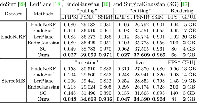


Abstract:Accurate geometric reconstruction of deformable tissues in monocular endoscopic video remains a fundamental challenge in robot-assisted minimally invasive surgery. Although recent volumetric and point primitive methods based on neural radiance fields (NeRF) and 3D Gaussian primitives have efficiently rendered surgical scenes, they still struggle with handling artifact-free tool occlusions and preserving fine anatomical details. These limitations stem from unrestricted Gaussian scaling and insufficient surface alignment constraints during reconstruction. To address these issues, we introduce Surgical Gaussian Surfels (SGS), which transforms anisotropic point primitives into surface-aligned elliptical splats by constraining the scale component of the Gaussian covariance matrix along the view-aligned axis. We predict accurate surfel motion fields using a lightweight Multi-Layer Perceptron (MLP) coupled with locality constraints to handle complex tissue deformations. We use homodirectional view-space positional gradients to capture fine image details by splitting Gaussian Surfels in over-reconstructed regions. In addition, we define surface normals as the direction of the steepest density change within each Gaussian surfel primitive, enabling accurate normal estimation without requiring monocular normal priors. We evaluate our method on two in-vivo surgical datasets, where it outperforms current state-of-the-art methods in surface geometry, normal map quality, and rendering efficiency, while remaining competitive in real-time rendering performance. We make our code available at https://github.com/aloma85/SurgicalGaussianSurfels
Image Matching Filtering and Refinement by Planes and Beyond
Nov 14, 2024


Abstract:This paper introduces a modular, non-deep learning method for filtering and refining sparse correspondences in image matching. Assuming that motion flow within the scene can be approximated by local homography transformations, matches are aggregated into overlapping clusters corresponding to virtual planes using an iterative RANSAC-based approach, with non-conforming correspondences discarded. Moreover, the underlying planar structural design provides an explicit map between local patches associated with the matches, enabling optional refinement of keypoint positions through cross-correlation template matching after patch reprojection. Finally, to enhance robustness and fault-tolerance against violations of the piece-wise planar approximation assumption, a further strategy is designed for minimizing relative patch distortion in the plane reprojection by introducing an intermediate homography that projects both patches into a common plane. The proposed method is extensively evaluated on standard datasets and image matching pipelines, and compared with state-of-the-art approaches. Unlike other current comparisons, the proposed benchmark also takes into account the more general, real, and practical cases where camera intrinsics are unavailable. Experimental results demonstrate that our proposed non-deep learning, geometry-based approach achieves performances that are either superior to or on par with recent state-of-the-art deep learning methods. Finally, this study suggests that there are still development potential in actual image matching solutions in the considered research direction, which could be in the future incorporated in novel deep image matching architectures.
ES-Gaussian: Gaussian Splatting Mapping via Error Space-Based Gaussian Completion
Oct 09, 2024Abstract:Accurate and affordable indoor 3D reconstruction is critical for effective robot navigation and interaction. Traditional LiDAR-based mapping provides high precision but is costly, heavy, and power-intensive, with limited ability for novel view rendering. Vision-based mapping, while cost-effective and capable of capturing visual data, often struggles with high-quality 3D reconstruction due to sparse point clouds. We propose ES-Gaussian, an end-to-end system using a low-altitude camera and single-line LiDAR for high-quality 3D indoor reconstruction. Our system features Visual Error Construction (VEC) to enhance sparse point clouds by identifying and correcting areas with insufficient geometric detail from 2D error maps. Additionally, we introduce a novel 3DGS initialization method guided by single-line LiDAR, overcoming the limitations of traditional multi-view setups and enabling effective reconstruction in resource-constrained environments. Extensive experimental results on our new Dreame-SR dataset and a publicly available dataset demonstrate that ES-Gaussian outperforms existing methods, particularly in challenging scenarios. The project page is available at https://chenlu-china.github.io/ES-Gaussian/.
GlobalPointer: Large-Scale Plane Adjustment with Bi-Convex Relaxation
Jul 19, 2024

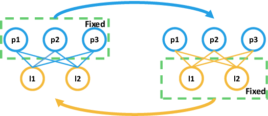
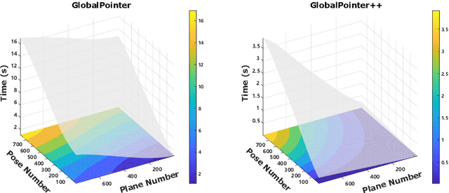
Abstract:Plane adjustment (PA) is crucial for many 3D applications, involving simultaneous pose estimation and plane recovery. Despite recent advancements, it remains a challenging problem in the realm of multi-view point cloud registration. Current state-of-the-art methods can achieve globally optimal convergence only with good initialization. Furthermore, their high time complexity renders them impractical for large-scale problems. To address these challenges, we first exploit a novel optimization strategy termed \textit{Bi-Convex Relaxation}, which decouples the original problem into two simpler sub-problems, reformulates each sub-problem using a convex relaxation technique, and alternately solves each one until the original problem converges. Building on this strategy, we propose two algorithmic variants for solving the plane adjustment problem, namely \textit{GlobalPointer} and \textit{GlobalPointer++}, based on point-to-plane and plane-to-plane errors, respectively. Extensive experiments on both synthetic and real datasets demonstrate that our method can perform large-scale plane adjustment with linear time complexity, larger convergence region, and robustness to poor initialization, while achieving similar accuracy as prior methods. The code is available at https://github.com/wu-cvgl/GlobalPointer.
DeDoDe v2: Analyzing and Improving the DeDoDe Keypoint Detector
Apr 13, 2024


Abstract:In this paper, we analyze and improve into the recently proposed DeDoDe keypoint detector. We focus our analysis on some key issues. First, we find that DeDoDe keypoints tend to cluster together, which we fix by performing non-max suppression on the target distribution of the detector during training. Second, we address issues related to data augmentation. In particular, the DeDoDe detector is sensitive to large rotations. We fix this by including 90-degree rotations as well as horizontal flips. Finally, the decoupled nature of the DeDoDe detector makes evaluation of downstream usefulness problematic. We fix this by matching the keypoints with a pretrained dense matcher (RoMa) and evaluating two-view pose estimates. We find that the original long training is detrimental to performance, and therefore propose a much shorter training schedule. We integrate all these improvements into our proposed detector DeDoDe v2 and evaluate it with the original DeDoDe descriptor on the MegaDepth-1500 and IMC2022 benchmarks. Our proposed detector significantly increases pose estimation results, notably from 75.9 to 78.3 mAA on the IMC2022 challenge. Code and weights are available at https://github.com/Parskatt/DeDoDe
SyreaNet: A Physically Guided Underwater Image Enhancement Framework Integrating Synthetic and Real Images
Feb 16, 2023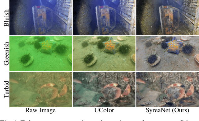
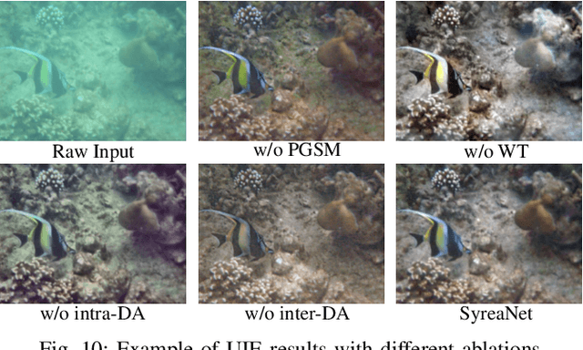
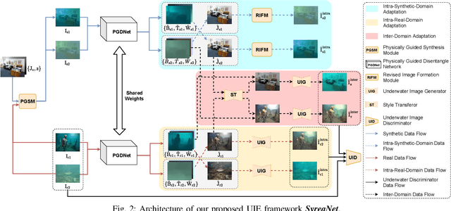
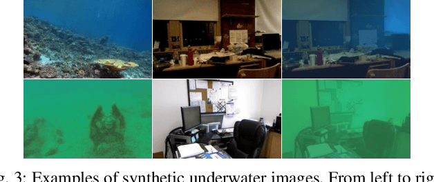
Abstract:Underwater image enhancement (UIE) is vital for high-level vision-related underwater tasks. Although learning-based UIE methods have made remarkable achievements in recent years, it's still challenging for them to consistently deal with various underwater conditions, which could be caused by: 1) the use of the simplified atmospheric image formation model in UIE may result in severe errors; 2) the network trained solely with synthetic images might have difficulty in generalizing well to real underwater images. In this work, we, for the first time, propose a framework \textit{SyreaNet} for UIE that integrates both synthetic and real data under the guidance of the revised underwater image formation model and novel domain adaptation (DA) strategies. First, an underwater image synthesis module based on the revised model is proposed. Then, a physically guided disentangled network is designed to predict the clear images by combining both synthetic and real underwater images. The intra- and inter-domain gaps are abridged by fully exchanging the domain knowledge. Extensive experiments demonstrate the superiority of our framework over other state-of-the-art (SOTA) learning-based UIE methods qualitatively and quantitatively. The code and dataset are publicly available at https://github.com/RockWenJJ/SyreaNet.git.
 Add to Chrome
 Add to Firefox
 Add to Edge