Hongliang Guo
CL-CoTNav: Closed-Loop Hierarchical Chain-of-Thought for Zero-Shot Object-Goal Navigation with Vision-Language Models
Apr 11, 2025Abstract:Visual Object Goal Navigation (ObjectNav) requires a robot to locate a target object in an unseen environment using egocentric observations. However, decision-making policies often struggle to transfer to unseen environments and novel target objects, which is the core generalization problem. Traditional end-to-end learning methods exacerbate this issue, as they rely on memorizing spatial patterns rather than employing structured reasoning, limiting their ability to generalize effectively. In this letter, we introduce Closed-Loop Hierarchical Chain-of-Thought Navigation (CL-CoTNav), a vision-language model (VLM)-driven ObjectNav framework that integrates structured reasoning and closed-loop feedback into navigation decision-making. To enhance generalization, we fine-tune a VLM using multi-turn question-answering (QA) data derived from human demonstration trajectories. This structured dataset enables hierarchical Chain-of-Thought (H-CoT) prompting, systematically extracting compositional knowledge to refine perception and decision-making, inspired by the human cognitive process of locating a target object through iterative reasoning steps. Additionally, we propose a Closed-Loop H-CoT mechanism that incorporates detection and reasoning confidence scores into training. This adaptive weighting strategy guides the model to prioritize high-confidence data pairs, mitigating the impact of noisy inputs and enhancing robustness against hallucinated or incorrect reasoning. Extensive experiments in the AI Habitat environment demonstrate CL-CoTNav's superior generalization to unseen scenes and novel object categories. Our method consistently outperforms state-of-the-art approaches in navigation success rate (SR) and success weighted by path length (SPL) by 22.4\%. We release our datasets, models, and supplementary videos on our project page.
Realm: Real-Time Line-of-Sight Maintenance in Multi-Robot Navigation with Unknown Obstacles
Feb 21, 2025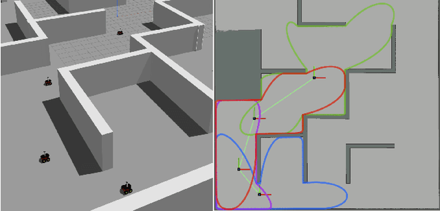
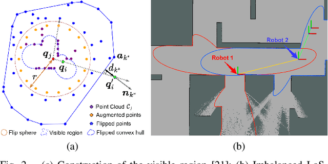
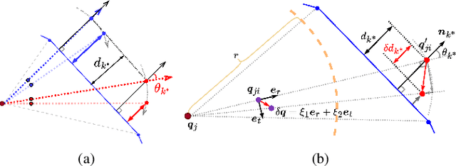
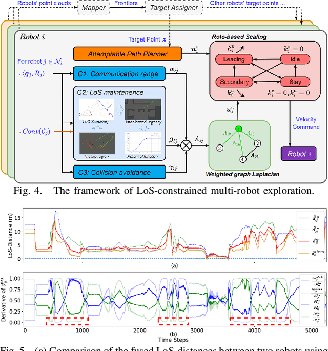
Abstract:Multi-robot navigation in complex environments relies on inter-robot communication and mutual observations for coordination and situational awareness. This paper studies the multi-robot navigation problem in unknown environments with line-of-sight (LoS) connectivity constraints. While previous works are limited to known environment models to derive the LoS constraints, this paper eliminates such requirements by directly formulating the LoS constraints between robots from their real-time point cloud measurements, leveraging point cloud visibility analysis techniques. We propose a novel LoS-distance metric to quantify both the urgency and sensitivity of losing LoS between robots considering potential robot movements. Moreover, to address the imbalanced urgency of losing LoS between two robots, we design a fusion function to capture the overall urgency while generating gradients that facilitate robots' collaborative movement to maintain LoS. The LoS constraints are encoded into a potential function that preserves the positivity of the Fiedler eigenvalue of the robots' network graph to ensure connectivity. Finally, we establish a LoS-constrained exploration framework that integrates the proposed connectivity controller. We showcase its applications in multi-robot exploration in complex unknown environments, where robots can always maintain the LoS connectivity through distributed sensing and communication, while collaboratively mapping the unknown environment. The implementations are open-sourced at https://github.com/bairuofei/LoS_constrained_navigation.
Multi-Robot Reliable Navigation in Uncertain Topological Environments with Graph Attention Networks
Nov 25, 2024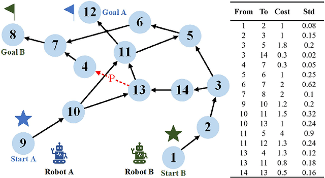
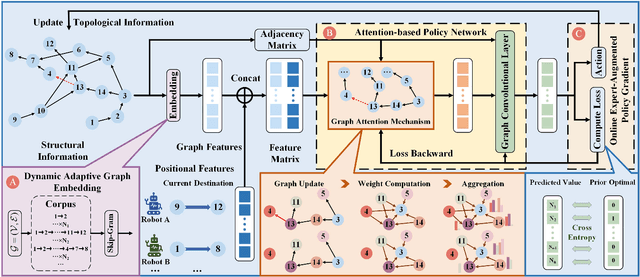


Abstract:This paper studies the multi-robot reliable navigation problem in uncertain topological networks, which aims at maximizing the robot team's on-time arrival probabilities in the face of road network uncertainties. The uncertainty in these networks stems from the unknown edge traversability, which is only revealed to the robot upon its arrival at the edge's starting node. Existing approaches often struggle to adapt to real-time network topology changes, making them unsuitable for varying topological environments. To address the challenge, we reformulate the problem into a Partially Observable Markov Decision Process (POMDP) framework and introduce the Dynamic Adaptive Graph Embedding method to capture the evolving nature of the navigation task. We further enhance each robot's policy learning process by integrating deep reinforcement learning with Graph Attention Networks (GATs), leveraging self-attention to focus on critical graph features. The proposed approach, namely Multi-Agent Routing in Variable Environments with Learning (MARVEL) employs the generalized policy gradient algorithm to optimize the robots' real-time decision-making process iteratively. We compare the performance of MARVEL with state-of-the-art reliable navigation algorithms as well as Canadian traveller problem solutions in a range of canonical transportation networks, demonstrating improved adaptability and performance in uncertain topological networks. Additionally, real-world experiments with two robots navigating within a self-constructed indoor environment with uncertain topological structures demonstrate MARVEL's practicality.
Collaborative Graph Exploration with Reduced Pose-SLAM Uncertainty via Submodular Optimization
Jul 01, 2024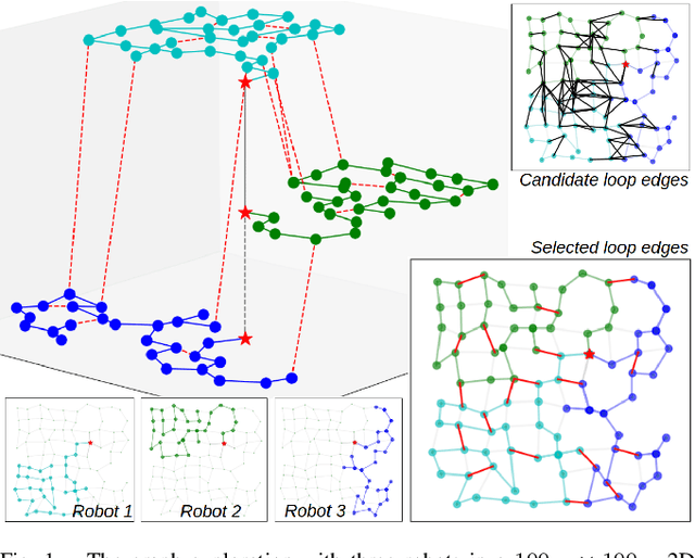
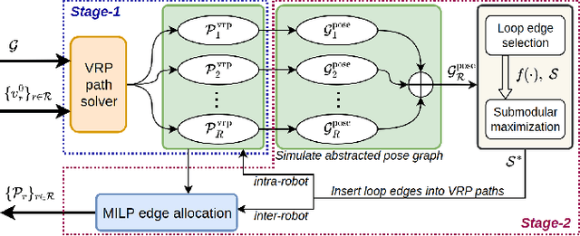
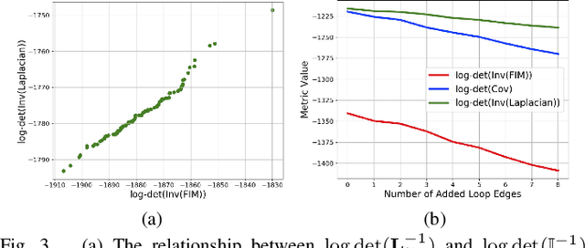
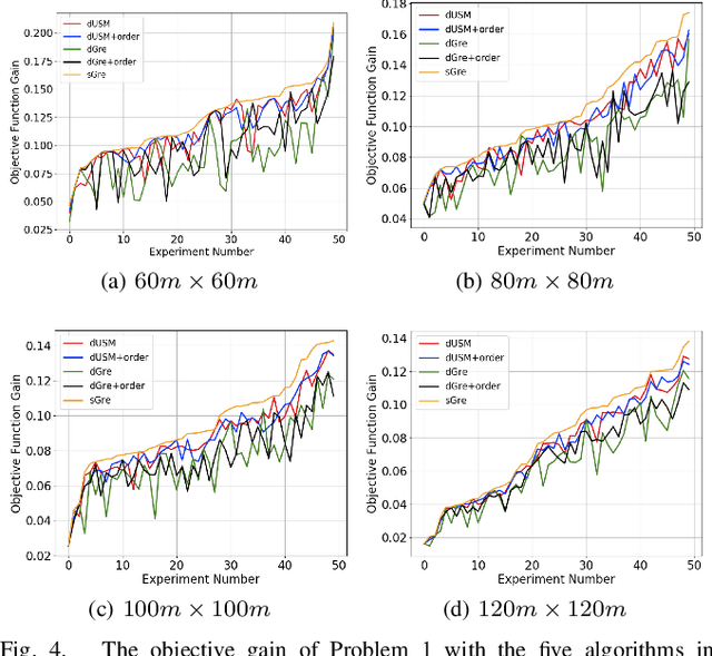
Abstract:This paper considers the collaborative graph exploration problem in GPS-denied environments, where a group of robots are required to cover a graph environment while maintaining reliable pose estimations in collaborative simultaneous localization and mapping (SLAM). Considering both objectives presents challenges for multi-robot pathfinding, as it involves the expensive covariance inference for SLAM uncertainty evaluation, especially considering various combinations of robots' paths. To reduce the computational complexity, we propose an efficient two-stage strategy where exploration paths are first generated for quick coverage, and then enhanced by adding informative and distance-efficient loop-closing actions, called loop edges, along the paths for reliable pose estimation. We formulate the latter problem as a non-monotone submodular maximization problem by relating SLAM uncertainty with pose graph topology, which (1) facilitates more efficient evaluation of SLAM uncertainty than covariance inference, and (2) allows the application of approximation algorithms in submodular optimization to provide optimality guarantees. We further introduce the ordering heuristics to improve objective values while preserving the optimality bound. Simulation experiments over randomly generated graph environments verify the efficiency of our methods in finding paths for quick coverage and enhanced pose graph reliability, and benchmark the performance of the approximation algorithms and the greedy-based algorithm in the loop edge selection problem. Our implementations will be open-source at https://github.com/bairuofei/CGE.
Graph-based SLAM-Aware Exploration with Prior Topo-Metric Information
Aug 31, 2023Abstract:Autonomous exploration requires the robot to explore an unknown environment while constructing an accurate map with the SLAM (Simultaneous Localization and Mapping) techniques. Without prior information, the exploratory performance is usually conservative due to the limited planning horizon. This paper exploits a prior topo-metric graph of the environment to benefit both the exploration efficiency and the pose graph accuracy in SLAM. Based on recent advancements in relating pose graph reliability with graph topology, we are able to formulate both objectives into a SLAM-aware path planning problem over the prior graph, which finds a fast exploration path with informative loop closures that globally stabilize the pose graph. Furthermore, we derive theoretical thresholds to speed up the greedy algorithm to the problem, which significantly prune non-optimal loop closures in iterations. The proposed planner is incorporated into a hierarchical exploration framework, with flexible features including path replanning and online prior map update that adds additional information to the prior graph. Extensive experiments indicate that our method has comparable exploration efficiency to others while consistently maintaining higher mapping accuracy in various environments. Our implementations will be open-source on GitHub.
Efficient Neural Neighborhood Search for Pickup and Delivery Problems
Apr 25, 2022


Abstract:We present an efficient Neural Neighborhood Search (N2S) approach for pickup and delivery problems (PDPs). In specific, we design a powerful Synthesis Attention that allows the vanilla self-attention to synthesize various types of features regarding a route solution. We also exploit two customized decoders that automatically learn to perform removal and reinsertion of a pickup-delivery node pair to tackle the precedence constraint. Additionally, a diversity enhancement scheme is leveraged to further ameliorate the performance. Our N2S is generic, and extensive experiments on two canonical PDP variants show that it can produce state-of-the-art results among existing neural methods. Moreover, it even outstrips the well-known LKH3 solver on the more constrained PDP variant. Our implementation for N2S is available online.
Multi-Scale Feature Aggregation by Cross-Scale Pixel-to-Region Relation Operation for Semantic Segmentation
Jun 03, 2021


Abstract:Exploiting multi-scale features has shown great potential in tackling semantic segmentation problems. The aggregation is commonly done with sum or concatenation (concat) followed by convolutional (conv) layers. However, it fully passes down the high-level context to the following hierarchy without considering their interrelation. In this work, we aim to enable the low-level feature to aggregate the complementary context from adjacent high-level feature maps by a cross-scale pixel-to-region relation operation. We leverage cross-scale context propagation to make the long-range dependency capturable even by the high-resolution low-level features. To this end, we employ an efficient feature pyramid network to obtain multi-scale features. We propose a Relational Semantics Extractor (RSE) and Relational Semantics Propagator (RSP) for context extraction and propagation respectively. Then we stack several RSP into an RSP head to achieve the progressive top-down distribution of the context. Experiment results on two challenging datasets Cityscapes and COCO demonstrate that the RSP head performs competitively on both semantic segmentation and panoptic segmentation with high efficiency. It outperforms DeeplabV3 [1] by 0.7% with 75% fewer FLOPs (multiply-adds) in the semantic segmentation task.
Online Multi-Target Tracking for Maneuvering Vehicles in Dynamic Road Context
Dec 02, 2019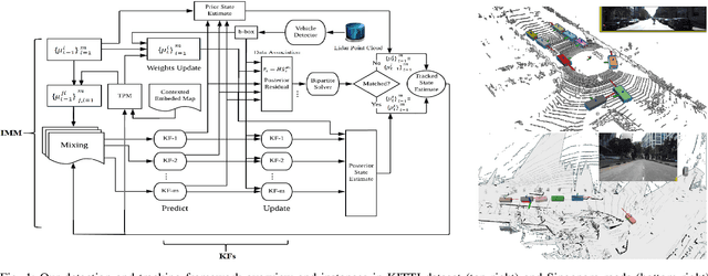
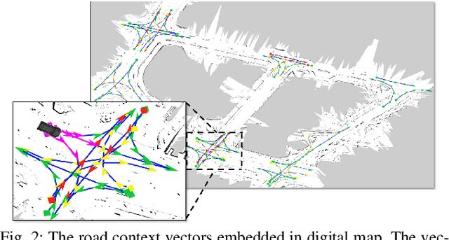
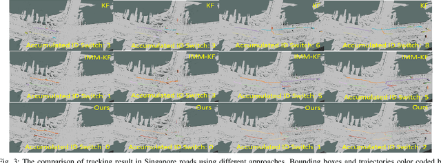
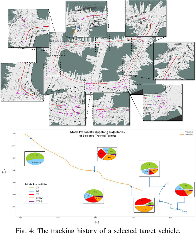
Abstract:Target detection and tracking provides crucial information for motion planning and decision making in autonomous driving. This paper proposes an online multi-object tracking (MOT) framework with tracking-by-detection for maneuvering vehicles under motion uncertainty in dynamic road context. We employ a point cloud based vehicle detector to provide real-time 3D bounding boxes of detected vehicles and conduct the online bipartite optimization of the maneuver-orientated data association between the detections and the targets. Kalman Filter (KF) is adopted as the backbone for multi-object tracking. In order to entertain the maneuvering uncertainty, we leverage the interacting multiple model (IMM) approach to obtain the \textit{a-posterior} residual as the cost for each association hypothesis, which is calculated with the hybrid model posterior (after mode-switch). Road context is integrated to conduct adjustments of the time varying transition probability matrix (TPM) of the IMM to regulate the maneuvers according to road segments and traffic sign/signals, with which the data association is performed in a unified spatial-temporal fashion. Experiments show our framework is able to effectively track multiple vehicles with maneuvers subject to dynamic road context and localization drift.
Porcellio scaber algorithm (PSA) for solving constrained optimization problems
Oct 11, 2017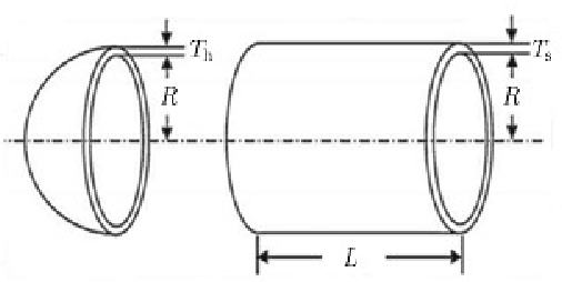
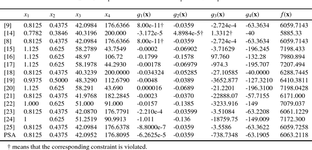

Abstract:In this paper, we extend a bio-inspired algorithm called the porcellio scaber algorithm (PSA) to solve constrained optimization problems, including a constrained mixed discrete-continuous nonlinear optimization problem. Our extensive experiment results based on benchmark optimization problems show that the PSA has a better performance than many existing methods or algorithms. The results indicate that the PSA is a promising algorithm for constrained optimization.
 Add to Chrome
 Add to Firefox
 Add to Edge