Gabriele Meoni
IC-EO: Interpretable Code-based assistant for Earth Observation
Jan 27, 2026Abstract:Despite recent advances in computer vision, Earth Observation (EO) analysis remains difficult to perform for the laymen, requiring expert knowledge and technical capabilities. Furthermore, many systems return black-box predictions that are difficult to audit or reproduce. Leveraging recent advances in tool LLMs, this study proposes a conversational, code-generating agent that transforms natural-language queries into executable, auditable Python workflows. The agent operates over a unified easily extendable API for classification, segmentation, detection (oriented bounding boxes), spectral indices, and geospatial operators. With our proposed framework, it is possible to control the results at three levels: (i) tool-level performance on public EO benchmarks; (ii) at the agent-level to understand the capacity to generate valid, hallucination-free code; and (iii) at the task-level on specific use cases. In this work, we select two use-cases of interest: land-composition mapping and post-wildfire damage assessment. The proposed agent outperforms general-purpose LLM/VLM baselines (GPT-4o, LLaVA), achieving 64.2% vs. 51.7% accuracy on land-composition and 50% vs. 0% on post-wildfire analysis, while producing results that are transparent and easy to interpret. By outputting verifiable code, the approach turns EO analysis into a transparent, reproducible process.
Energy efficiency analysis of Spiking Neural Networks for space applications
May 16, 2025Abstract:While the exponential growth of the space sector and new operative concepts ask for higher spacecraft autonomy, the development of AI-assisted space systems was so far hindered by the low availability of power and energy typical of space applications. In this context, Spiking Neural Networks (SNN) are highly attractive due to their theoretically superior energy efficiency due to their inherently sparse activity induced by neurons communicating by means of binary spikes. Nevertheless, the ability of SNN to reach such efficiency on real world tasks is still to be demonstrated in practice. To evaluate the feasibility of utilizing SNN onboard spacecraft, this work presents a numerical analysis and comparison of different SNN techniques applied to scene classification for the EuroSAT dataset. Such tasks are of primary importance for space applications and constitute a valuable test case given the abundance of competitive methods available to establish a benchmark. Particular emphasis is placed on models based on temporal coding, where crucial information is encoded in the timing of neuron spikes. These models promise even greater efficiency of resulting networks, as they maximize the sparsity properties inherent in SNN. A reliable metric capable of comparing different architectures in a hardware-agnostic way is developed to establish a clear theoretical dependence between architecture parameters and the energy consumption that can be expected onboard the spacecraft. The potential of this novel method and his flexibility to describe specific hardware platforms is demonstrated by its application to predicting the energy consumption of a BrainChip Akida AKD1000 neuromorphic processor.
Rapid Distributed Fine-tuning of a Segmentation Model Onboard Satellites
Nov 26, 2024Abstract:Segmentation of Earth observation (EO) satellite data is critical for natural hazard analysis and disaster response. However, processing EO data at ground stations introduces delays due to data transmission bottlenecks and communication windows. Using segmentation models capable of near-real-time data analysis onboard satellites can therefore improve response times. This study presents a proof-of-concept using MobileSAM, a lightweight, pre-trained segmentation model, onboard Unibap iX10-100 satellite hardware. We demonstrate the segmentation of water bodies from Sentinel-2 satellite imagery and integrate MobileSAM with PASEOS, an open-source Python module that simulates satellite operations. This integration allows us to evaluate MobileSAM's performance under simulated conditions of a satellite constellation. Our research investigates the potential of fine-tuning MobileSAM in a decentralised way onboard multiple satellites in rapid response to a disaster. Our findings show that MobileSAM can be rapidly fine-tuned and benefits from decentralised learning, considering the constraints imposed by the simulated orbital environment. We observe improvements in segmentation performance with minimal training data and fast fine-tuning when satellites frequently communicate model updates. This study contributes to the field of onboard AI by emphasising the benefits of decentralised learning and fine-tuning pre-trained models for rapid response scenarios. Our work builds on recent related research at a critical time; as extreme weather events increase in frequency and magnitude, rapid response with onboard data analysis is essential.
Enhancing Maritime Situational Awareness through End-to-End Onboard Raw Data Analysis
Nov 05, 2024


Abstract:Satellite-based onboard data processing is crucial for time-sensitive applications requiring timely and efficient rapid response. Advances in edge artificial intelligence are shifting computational power from ground-based centers to on-orbit platforms, transforming the "sensing-communication-decision-feedback" cycle and reducing latency from acquisition to delivery. The current research presents a framework addressing the strict bandwidth, energy, and latency constraints of small satellites, focusing on maritime monitoring. The study contributes three main innovations. Firstly, it investigates the application of deep learning techniques for direct ship detection and classification from raw satellite imagery. By simplifying the onboard processing chain, our approach facilitates direct analyses without requiring computationally intensive steps such as calibration and ortho-rectification. Secondly, to address the scarcity of raw satellite data, we introduce two novel datasets, VDS2Raw and VDV2Raw, which are derived from raw data from Sentinel-2 and Vegetation and Environment Monitoring New Micro Satellite (VENuS) missions, respectively, and enriched with Automatic Identification System (AIS) records. Thirdly, we characterize the tasks' optimal single and multiple spectral band combinations through statistical and feature-based analyses validated on both datasets. In sum, we demonstrate the feasibility of the proposed method through a proof-of-concept on CubeSat-like hardware, confirming the models' potential for operational satellite-based maritime monitoring.
On the impact of key design aspects in simulated Hybrid Quantum Neural Networks for Earth Observation
Oct 11, 2024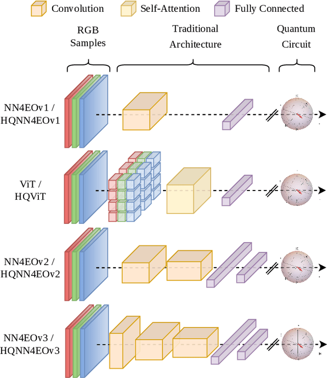

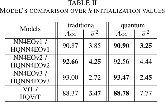

Abstract:Quantum computing has introduced novel perspectives for tackling and improving machine learning tasks. Moreover, the integration of quantum technologies together with well-known deep learning (DL) architectures has emerged as a potential research trend gaining attraction across various domains, such as Earth Observation (EO) and many other research fields. However, prior related works in EO literature have mainly focused on convolutional architectural advancements, leaving several essential topics unexplored. Consequently, this research investigates through three cases of study fundamental aspects of hybrid quantum machine models for EO tasks aiming to provide a solid groundwork for future research studies towards more adequate simulations and looking at the post-NISQ era. More in detail, we firstly (1) investigate how different quantum libraries behave when training hybrid quantum models, assessing their computational efficiency and effectiveness. Secondly, (2) we analyze the stability/sensitivity to initialization values (i.e., seed values) in both traditional model and quantum-enhanced counterparts. Finally, (3) we explore the benefits of hybrid quantum attention-based models in EO applications, examining how integrating quantum circuits into ViTs can improve model performance.
AI techniques for near real-time monitoring of contaminants in coastal waters on board future Phisat-2 mission
Apr 30, 2024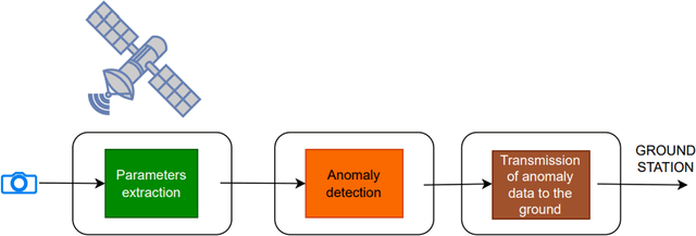
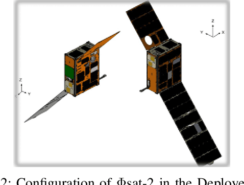
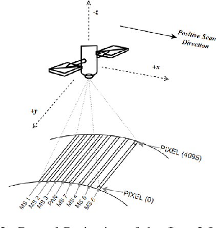
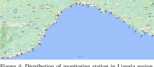
Abstract:Differently from conventional procedures, the proposed solution advocates for a groundbreaking paradigm in water quality monitoring through the integration of satellite Remote Sensing (RS) data, Artificial Intelligence (AI) techniques, and onboard processing. The objective is to offer nearly real-time detection of contaminants in coastal waters addressing a significant gap in the existing literature. Moreover, the expected outcomes include substantial advancements in environmental monitoring, public health protection, and resource conservation. The specific focus of our study is on the estimation of Turbidity and pH parameters, for their implications on human and aquatic health. Nevertheless, the designed framework can be extended to include other parameters of interest in the water environment and beyond. Originating from our participation in the European Space Agency (ESA) OrbitalAI Challenge, this article describes the distinctive opportunities and issues for the contaminants monitoring on the Phisat-2 mission. The specific characteristics of this mission, with the tools made available, will be presented, with the methodology proposed by the authors for the onboard monitoring of water contaminants in near real-time. Preliminary promising results are discussed and in progress and future work introduced.
Implicit Assimilation of Sparse In Situ Data for Dense & Global Storm Surge Forecasting
Apr 05, 2024


Abstract:Hurricanes and coastal floods are among the most disastrous natural hazards. Both are intimately related to storm surges, as their causes and effects, respectively. However, the short-term forecasting of storm surges has proven challenging, especially when targeting previously unseen locations or sites without tidal gauges. Furthermore, recent work improved short and medium-term weather forecasting but the handling of raw unassimilated data remains non-trivial. In this paper, we tackle both challenges and demonstrate that neural networks can implicitly assimilate sparse in situ tide gauge data with coarse ocean state reanalysis in order to forecast storm surges. We curate a global dataset to learn and validate the dense prediction of storm surges, building on preceding efforts. Other than prior work limited to known gauges, our approach extends to ungauged sites, paving the way for global storm surge forecasting.
Towards Large-scale Network Emulation on Analog Neuromorphic Hardware
Jan 30, 2024Abstract:We present a novel software feature for the BrainScaleS-2 accelerated neuromorphic platform that facilitates the emulation of partitioned large-scale spiking neural networks. This approach is well suited for many deep spiking neural networks, where the constraint of the largest recurrent subnetwork fitting on the substrate or the limited fan-in of neurons is often not a limitation in practice. We demonstrate the training of two deep spiking neural network models, using the MNIST and EuroSAT datasets, that exceed the physical size constraints of a single-chip BrainScaleS-2 system. The ability to emulate and train networks larger than the substrate provides a pathway for accurate performance evaluation in planned or scaled systems, ultimately advancing the development and understanding of large-scale models and neuromorphic computing architectures.
Monitoring water contaminants in coastal areas through ML algorithms leveraging atmospherically corrected Sentinel-2 data
Jan 08, 2024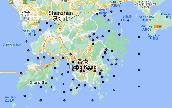

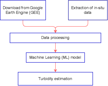

Abstract:Monitoring water contaminants is of paramount importance, ensuring public health and environmental well-being. Turbidity, a key parameter, poses a significant problem, affecting water quality. Its accurate assessment is crucial for safeguarding ecosystems and human consumption, demanding meticulous attention and action. For this, our study pioneers a novel approach to monitor the Turbidity contaminant, integrating CatBoost Machine Learning (ML) with high-resolution data from Sentinel-2 Level-2A. Traditional methods are labor-intensive while CatBoost offers an efficient solution, excelling in predictive accuracy. Leveraging atmospherically corrected Sentinel-2 data through the Google Earth Engine (GEE), our study contributes to scalable and precise Turbidity monitoring. A specific tabular dataset derived from Hong Kong contaminants monitoring stations enriches our study, providing region-specific insights. Results showcase the viability of this integrated approach, laying the foundation for adopting advanced techniques in global water quality management.
On the Generation of a Synthetic Event-Based Vision Dataset for Navigation and Landing
Aug 01, 2023


Abstract:An event-based camera outputs an event whenever a change in scene brightness of a preset magnitude is detected at a particular pixel location in the sensor plane. The resulting sparse and asynchronous output coupled with the high dynamic range and temporal resolution of this novel camera motivate the study of event-based cameras for navigation and landing applications. However, the lack of real-world and synthetic datasets to support this line of research has limited its consideration for onboard use. This paper presents a methodology and a software pipeline for generating event-based vision datasets from optimal landing trajectories during the approach of a target body. We construct sequences of photorealistic images of the lunar surface with the Planet and Asteroid Natural Scene Generation Utility at different viewpoints along a set of optimal descent trajectories obtained by varying the boundary conditions. The generated image sequences are then converted into event streams by means of an event-based camera emulator. We demonstrate that the pipeline can generate realistic event-based representations of surface features by constructing a dataset of 500 trajectories, complete with event streams and motion field ground truth data. We anticipate that novel event-based vision datasets can be generated using this pipeline to support various spacecraft pose reconstruction problems given events as input, and we hope that the proposed methodology would attract the attention of researchers working at the intersection of neuromorphic vision and guidance navigation and control.
 Add to Chrome
 Add to Firefox
 Add to Edge