Federico Serva
IceCloudNet: 3D reconstruction of cloud ice from Meteosat SEVIRI
Oct 05, 2024Abstract:IceCloudNet is a novel method based on machine learning able to predict high-quality vertically resolved cloud ice water contents (IWC) and ice crystal number concentrations (N$_\textrm{ice}$). The predictions come at the spatio-temporal coverage and resolution of geostationary satellite observations (SEVIRI) and the vertical resolution of active satellite retrievals (DARDAR). IceCloudNet consists of a ConvNeXt-based U-Net and a 3D PatchGAN discriminator model and is trained by predicting DARDAR profiles from co-located SEVIRI images. Despite the sparse availability of DARDAR data due to its narrow overpass, IceCloudNet is able to predict cloud occurrence, spatial structure, and microphysical properties with high precision. The model has been applied to ten years of SEVIRI data, producing a dataset of vertically resolved IWC and N$_\textrm{ice}$ of clouds containing ice with a 3 kmx3 kmx240 mx15 minute resolution in a spatial domain of 30{\deg}W to 30{\deg}E and 30{\deg}S to 30{\deg}N. The produced dataset increases the availability of vertical cloud profiles, for the period when DARDAR is available, by more than six orders of magnitude and moreover, IceCloudNet is able to produce vertical cloud profiles beyond the lifetime of the recently ended satellite missions underlying DARDAR.
Implicit Assimilation of Sparse In Situ Data for Dense & Global Storm Surge Forecasting
Apr 05, 2024


Abstract:Hurricanes and coastal floods are among the most disastrous natural hazards. Both are intimately related to storm surges, as their causes and effects, respectively. However, the short-term forecasting of storm surges has proven challenging, especially when targeting previously unseen locations or sites without tidal gauges. Furthermore, recent work improved short and medium-term weather forecasting but the handling of raw unassimilated data remains non-trivial. In this paper, we tackle both challenges and demonstrate that neural networks can implicitly assimilate sparse in situ tide gauge data with coarse ocean state reanalysis in order to forecast storm surges. We curate a global dataset to learn and validate the dense prediction of storm surges, building on preceding efforts. Other than prior work limited to known gauges, our approach extends to ungauged sites, paving the way for global storm surge forecasting.
IceCloudNet: Cirrus and mixed-phase cloud prediction from SEVIRI input learned from sparse supervision
Oct 05, 2023


Abstract:Clouds containing ice particles play a crucial role in the climate system. Yet they remain a source of great uncertainty in climate models and future climate projections. In this work, we create a new observational constraint of regime-dependent ice microphysical properties at the spatio-temporal coverage of geostationary satellite instruments and the quality of active satellite retrievals. We achieve this by training a convolutional neural network on three years of SEVIRI and DARDAR data sets. This work will enable novel research to improve ice cloud process understanding and hence, reduce uncertainties in a changing climate and help assess geoengineering methods for cirrus clouds.
THRawS: A Novel Dataset for Thermal Hotspots Detection in Raw Sentinel-2 Data
May 12, 2023


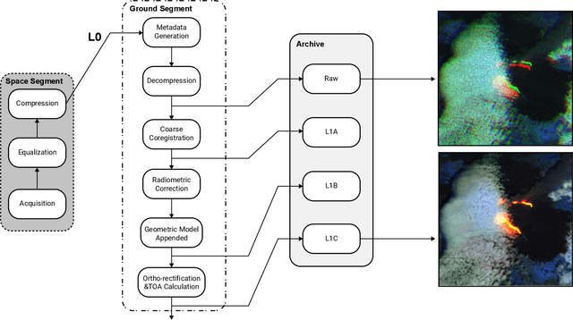
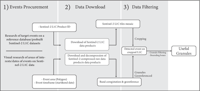
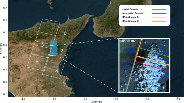
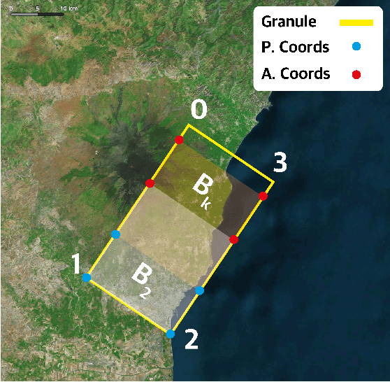
Abstract:Nowadays, most of the datasets leveraging space-borne Earth Observation (EO) data are based on high-end levels products, which are ortho-rectified, coregistered, calibrated, and further processed to mitigate the impact of noise and distortions. Nevertheless, given the growing interest to apply Artificial Intelligence (AI) onboard satellites for time-critical applications, such as natural disaster response, providing raw satellite images could be useful to foster the research on energy-efficient pre-processing algorithms and AI models for onboard-satellite applications. In this framework, we present THRawS, the first dataset composed of Sentinel-2 (S-2) raw data containing warm temperature hotspots (wildfires and volcanic eruptions). To foster the realisation of robust AI architectures, the dataset gathers data from all over the globe. Furthermore, we designed a custom methodology to identify events in raw data starting from the corresponding Level-1C (L1C) products. Indeed, given the availability of state-of-the-art algorithms for thermal anomalies detection on the L1C tiles, we detect such events on these latter and we then re-project them on the corresponding raw images. Additionally, to deal with unprocessed data, we devise a lightweight coarse coregisteration and georeferencing strategy. The developed dataset is comprehensive of more than 100 samples containing wildfires, volcanic eruptions, and event-free volcanic areas to enable both warm-events detection and general classification applications. Finally, we compare performances between the proposed coarse spatial coregistration technique and the SuperGlue Deep Neural Network method to highlight the different constraints in terms of timing and quality of spatial registration to minimise the spatial displacement error for a specific scene.
 Add to Chrome
 Add to Firefox
 Add to Edge