Roberto Del Prete
Supervised and self-supervised land-cover segmentation & classification of the Biesbosch wetlands
May 27, 2025Abstract:Accurate wetland land-cover classification is essential for environmental monitoring, biodiversity assessment, and sustainable ecosystem management. However, the scarcity of annotated data, especially for high-resolution satellite imagery, poses a significant challenge for supervised learning approaches. To tackle this issue, this study presents a methodology for wetland land-cover segmentation and classification that adopts both supervised and self-supervised learning (SSL). We train a U-Net model from scratch on Sentinel-2 imagery across six wetland regions in the Netherlands, achieving a baseline model accuracy of 85.26%. Addressing the limited availability of labeled data, the results show that SSL pretraining with an autoencoder can improve accuracy, especially for the high-resolution imagery where it is more difficult to obtain labeled data, reaching an accuracy of 88.23%. Furthermore, we introduce a framework to scale manually annotated high-resolution labels to medium-resolution inputs. While the quantitative performance between resolutions is comparable, high-resolution imagery provides significantly sharper segmentation boundaries and finer spatial detail. As part of this work, we also contribute a curated Sentinel-2 dataset with Dynamic World labels, tailored for wetland classification tasks and made publicly available.
Enhancing Maritime Situational Awareness through End-to-End Onboard Raw Data Analysis
Nov 05, 2024


Abstract:Satellite-based onboard data processing is crucial for time-sensitive applications requiring timely and efficient rapid response. Advances in edge artificial intelligence are shifting computational power from ground-based centers to on-orbit platforms, transforming the "sensing-communication-decision-feedback" cycle and reducing latency from acquisition to delivery. The current research presents a framework addressing the strict bandwidth, energy, and latency constraints of small satellites, focusing on maritime monitoring. The study contributes three main innovations. Firstly, it investigates the application of deep learning techniques for direct ship detection and classification from raw satellite imagery. By simplifying the onboard processing chain, our approach facilitates direct analyses without requiring computationally intensive steps such as calibration and ortho-rectification. Secondly, to address the scarcity of raw satellite data, we introduce two novel datasets, VDS2Raw and VDV2Raw, which are derived from raw data from Sentinel-2 and Vegetation and Environment Monitoring New Micro Satellite (VENuS) missions, respectively, and enriched with Automatic Identification System (AIS) records. Thirdly, we characterize the tasks' optimal single and multiple spectral band combinations through statistical and feature-based analyses validated on both datasets. In sum, we demonstrate the feasibility of the proposed method through a proof-of-concept on CubeSat-like hardware, confirming the models' potential for operational satellite-based maritime monitoring.
THRawS: A Novel Dataset for Thermal Hotspots Detection in Raw Sentinel-2 Data
May 12, 2023


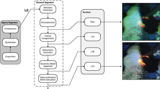
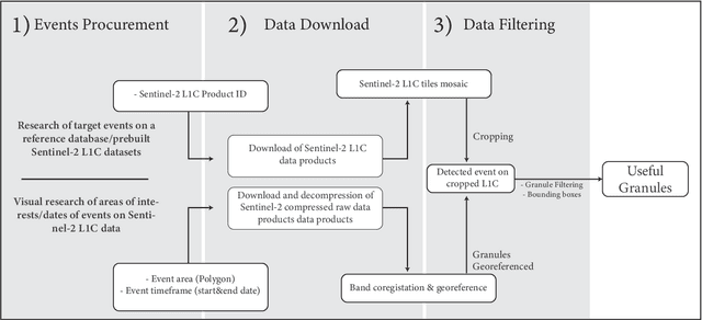
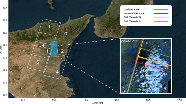
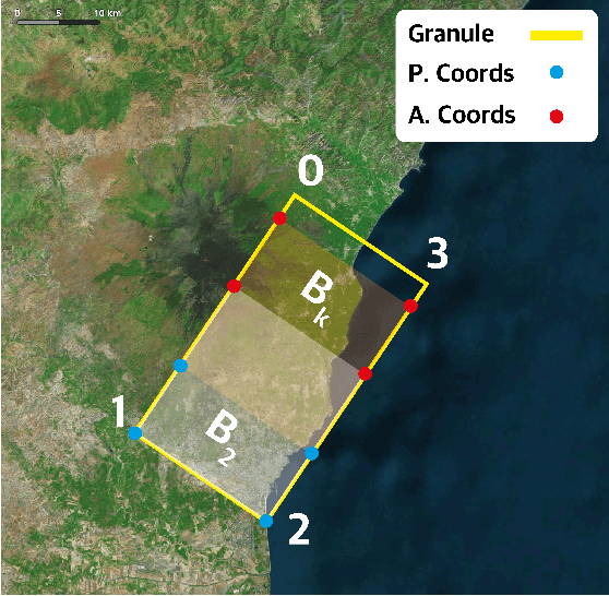
Abstract:Nowadays, most of the datasets leveraging space-borne Earth Observation (EO) data are based on high-end levels products, which are ortho-rectified, coregistered, calibrated, and further processed to mitigate the impact of noise and distortions. Nevertheless, given the growing interest to apply Artificial Intelligence (AI) onboard satellites for time-critical applications, such as natural disaster response, providing raw satellite images could be useful to foster the research on energy-efficient pre-processing algorithms and AI models for onboard-satellite applications. In this framework, we present THRawS, the first dataset composed of Sentinel-2 (S-2) raw data containing warm temperature hotspots (wildfires and volcanic eruptions). To foster the realisation of robust AI architectures, the dataset gathers data from all over the globe. Furthermore, we designed a custom methodology to identify events in raw data starting from the corresponding Level-1C (L1C) products. Indeed, given the availability of state-of-the-art algorithms for thermal anomalies detection on the L1C tiles, we detect such events on these latter and we then re-project them on the corresponding raw images. Additionally, to deal with unprocessed data, we devise a lightweight coarse coregisteration and georeferencing strategy. The developed dataset is comprehensive of more than 100 samples containing wildfires, volcanic eruptions, and event-free volcanic areas to enable both warm-events detection and general classification applications. Finally, we compare performances between the proposed coarse spatial coregistration technique and the SuperGlue Deep Neural Network method to highlight the different constraints in terms of timing and quality of spatial registration to minimise the spatial displacement error for a specific scene.
 Add to Chrome
 Add to Firefox
 Add to Edge