Bowen Xu
D-CORE: Incentivizing Task Decomposition in Large Reasoning Models for Complex Tool Use
Feb 02, 2026Abstract:Effective tool use and reasoning are essential capabilities for large reasoning models~(LRMs) to address complex real-world problems. Through empirical analysis, we identify that current LRMs lack the capability of sub-task decomposition in complex tool use scenarios, leading to Lazy Reasoning. To address this, we propose a two-stage training framework D-CORE~(\underline{\textbf{D}}ecomposing tasks and \underline{\textbf{Co}}mposing \underline{\textbf{Re}}asoning processes) that first incentivize the LRMs' task decomposition reasoning capability via self-distillation, followed by diversity-aware reinforcement learning~(RL) to restore LRMs' reflective reasoning capability. D-CORE achieves robust tool-use improvements across diverse benchmarks and model scales. Experiments on BFCLv3 demonstrate superiority of our method: D-CORE-8B reaches 77.7\% accuracy, surpassing the best-performing 8B model by 5.7\%. Meanwhile, D-CORE-14B establishes a new state-of-the-art at 79.3\%, outperforming 70B models despite being 5$\times$ smaller. The source code is available at https://github.com/alibaba/EfficientAI.
How Do Semantically Equivalent Code Transformations Impact Membership Inference on LLMs for Code?
Dec 17, 2025Abstract:The success of large language models for code relies on vast amounts of code data, including public open-source repositories, such as GitHub, and private, confidential code from companies. This raises concerns about intellectual property compliance and the potential unauthorized use of license-restricted code. While membership inference (MI) techniques have been proposed to detect such unauthorized usage, their effectiveness can be undermined by semantically equivalent code transformation techniques, which modify code syntax while preserving semantic. In this work, we systematically investigate whether semantically equivalent code transformation rules might be leveraged to evade MI detection. The results reveal that model accuracy drops by only 1.5% in the worst case for each rule, demonstrating that transformed datasets can effectively serve as substitutes for fine-tuning. Additionally, we find that one of the rules (RenameVariable) reduces MI success by 10.19%, highlighting its potential to obscure the presence of restricted code. To validate these findings, we conduct a causal analysis confirming that variable renaming has the strongest causal effect in disrupting MI detection. Notably, we find that combining multiple transformations does not further reduce MI effectiveness. Our results expose a critical loophole in license compliance enforcement for training large language models for code, showing that MI detection can be substantially weakened by transformation-based obfuscation techniques.
Understanding Privacy Risks in Code Models Through Training Dynamics: A Causal Approach
Dec 09, 2025Abstract:Large language models for code (LLM4Code) have greatly improved developer productivity but also raise privacy concerns due to their reliance on open-source repositories containing abundant personally identifiable information (PII). Prior work shows that commercial models can reproduce sensitive PII, yet existing studies largely treat PII as a single category and overlook the heterogeneous risks among different types. We investigate whether distinct PII types vary in their likelihood of being learned and leaked by LLM4Code, and whether this relationship is causal. Our methodology includes building a dataset with diverse PII types, fine-tuning representative models of different scales, computing training dynamics on real PII data, and formulating a structural causal model to estimate the causal effect of learnability on leakage. Results show that leakage risks differ substantially across PII types and correlate with their training dynamics: easy-to-learn instances such as IP addresses exhibit higher leakage, while harder types such as keys and passwords leak less frequently. Ambiguous types show mixed behaviors. This work provides the first causal evidence that leakage risks are type-dependent and offers guidance for developing type-aware and learnability-aware defenses for LLM4Code.
DiagnoLLM: A Hybrid Bayesian Neural Language Framework for Interpretable Disease Diagnosis
Nov 16, 2025Abstract:Building trustworthy clinical AI systems requires not only accurate predictions but also transparent, biologically grounded explanations. We present \texttt{DiagnoLLM}, a hybrid framework that integrates Bayesian deconvolution, eQTL-guided deep learning, and LLM-based narrative generation for interpretable disease diagnosis. DiagnoLLM begins with GP-unmix, a Gaussian Process-based hierarchical model that infers cell-type-specific gene expression profiles from bulk and single-cell RNA-seq data while modeling biological uncertainty. These features, combined with regulatory priors from eQTL analysis, power a neural classifier that achieves high predictive performance in Alzheimer's Disease (AD) detection (88.0\% accuracy). To support human understanding and trust, we introduce an LLM-based reasoning module that translates model outputs into audience-specific diagnostic reports, grounded in clinical features, attribution signals, and domain knowledge. Human evaluations confirm that these reports are accurate, actionable, and appropriately tailored for both physicians and patients. Our findings show that LLMs, when deployed as post-hoc reasoners rather than end-to-end predictors, can serve as effective communicators within hybrid diagnostic pipelines.
GLM-4.5: Agentic, Reasoning, and Coding (ARC) Foundation Models
Aug 08, 2025Abstract:We present GLM-4.5, an open-source Mixture-of-Experts (MoE) large language model with 355B total parameters and 32B activated parameters, featuring a hybrid reasoning method that supports both thinking and direct response modes. Through multi-stage training on 23T tokens and comprehensive post-training with expert model iteration and reinforcement learning, GLM-4.5 achieves strong performance across agentic, reasoning, and coding (ARC) tasks, scoring 70.1% on TAU-Bench, 91.0% on AIME 24, and 64.2% on SWE-bench Verified. With much fewer parameters than several competitors, GLM-4.5 ranks 3rd overall among all evaluated models and 2nd on agentic benchmarks. We release both GLM-4.5 (355B parameters) and a compact version, GLM-4.5-Air (106B parameters), to advance research in reasoning and agentic AI systems. Code, models, and more information are available at https://github.com/zai-org/GLM-4.5.
La RoSA: Enhancing LLM Efficiency via Layerwise Rotated Sparse Activation
Jul 02, 2025


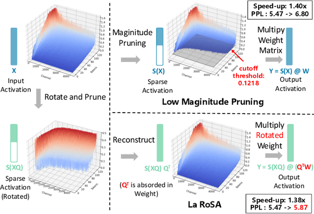
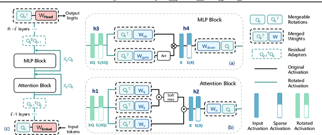
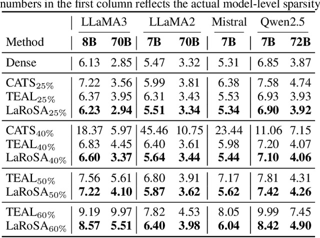
Abstract:Activation sparsity can reduce the computational overhead and memory transfers during the forward pass of Large Language Model (LLM) inference. Existing methods face limitations, either demanding time-consuming recovery training that hinders real-world adoption, or relying on empirical magnitude-based pruning, which causes fluctuating sparsity and unstable inference speed-up. This paper introduces LaRoSA (Layerwise Rotated Sparse Activation), a novel method for activation sparsification designed to improve LLM efficiency without requiring additional training or magnitude-based pruning. We leverage layerwise orthogonal rotations to transform input activations into rotated forms that are more suitable for sparsification. By employing a Top-K selection approach within the rotated activations, we achieve consistent model-level sparsity and reliable wall-clock time speed-up. LaRoSA is effective across various sizes and types of LLMs, demonstrating minimal performance degradation and robust inference acceleration. Specifically, for LLaMA2-7B at 40% sparsity, LaRoSA achieves a mere 0.17 perplexity gap with a consistent 1.30x wall-clock time speed-up, and reduces the accuracy gap in zero-shot tasks compared to the dense model to just 0.54%, while surpassing TEAL by 1.77% and CATS by 17.14%.
HEPP: Hyper-efficient Perception and Planning for High-speed Obstacle Avoidance of UAVs
May 23, 2025Abstract:High-speed obstacle avoidance of uncrewed aerial vehicles (UAVs) in cluttered environments is a significant challenge. Existing UAV planning and obstacle avoidance systems can only fly at moderate speeds or at high speeds over empty or sparse fields. In this article, we propose a hyper-efficient perception and planning system for the high-speed obstacle avoidance of UAVs. The system mainly consists of three modules: 1) A novel incremental robocentric mapping method with distance and gradient information, which takes 89.5% less time compared to existing methods. 2) A novel obstacle-aware topological path search method that generates multiple distinct paths. 3) An adaptive gradient-based high-speed trajectory generation method with a novel time pre-allocation algorithm. With these innovations, the system has an excellent real-time performance with only milliseconds latency in each iteration, taking 79.24% less time than existing methods at high speeds (15 m/s in cluttered environments), allowing UAVs to fly swiftly and avoid obstacles in cluttered environments. The planned trajectory of the UAV is close to the global optimum in both temporal and spatial domains. Finally, extensive validations in both simulation and real-world experiments demonstrate the effectiveness of our proposed system for high-speed navigation in cluttered environments.
EVALOOP: Assessing LLM Robustness in Programming from a Self-consistency Perspective
May 18, 2025


Abstract:Assessing the programming capabilities of Large Language Models (LLMs) is crucial for their effective use in software engineering. Current evaluations, however, predominantly measure the accuracy of generated code on static benchmarks, neglecting the critical aspect of model robustness during programming tasks. While adversarial attacks offer insights on model robustness, their effectiveness is limited and evaluation could be constrained. Current adversarial attack methods for robustness evaluation yield inconsistent results, struggling to provide a unified evaluation across different LLMs. We introduce EVALOOP, a novel assessment framework that evaluate the robustness from a self-consistency perspective, i.e., leveraging the natural duality inherent in popular software engineering tasks, e.g., code generation and code summarization. EVALOOP initiates a self-contained feedback loop: an LLM generates output (e.g., code) from an input (e.g., natural language specification), and then use the generated output as the input to produce a new output (e.g., summarizes that code into a new specification). EVALOOP repeats the process to assess the effectiveness of EVALOOP in each loop. This cyclical strategy intrinsically evaluates robustness without rely on any external attack setups, providing a unified metric to evaluate LLMs' robustness in programming. We evaluate 16 prominent LLMs (e.g., GPT-4.1, O4-mini) on EVALOOP and found that EVALOOP typically induces a 5.01%-19.31% absolute drop in pass@1 performance within ten loops. Intriguingly, robustness does not always align with initial performance (i.e., one-time query); for instance, GPT-3.5-Turbo, despite superior initial code generation compared to DeepSeek-V2, demonstrated lower robustness over repeated evaluation loop.
Flying in Highly Dynamic Environments with End-to-end Learning Approach
Mar 18, 2025Abstract:Obstacle avoidance for unmanned aerial vehicles like quadrotors is a popular research topic. Most existing research focuses only on static environments, and obstacle avoidance in environments with multiple dynamic obstacles remains challenging. This paper proposes a novel deep-reinforcement learning-based approach for the quadrotors to navigate through highly dynamic environments. We propose a lidar data encoder to extract obstacle information from the massive point cloud data from the lidar. Multi frames of historical scans will be compressed into a 2-dimension obstacle map while maintaining the obstacle features required. An end-to-end deep neural network is trained to extract the kinematics of dynamic and static obstacles from the obstacle map, and it will generate acceleration commands to the quadrotor to control it to avoid these obstacles. Our approach contains perception and navigating functions in a single neural network, which can change from a navigating state into a hovering state without mode switching. We also present simulations and real-world experiments to show the effectiveness of our approach while navigating in highly dynamic cluttered environments.
NeurOp-Diff:Continuous Remote Sensing Image Super-Resolution via Neural Operator Diffusion
Jan 15, 2025Abstract:Most publicly accessible remote sensing data suffer from low resolution, limiting their practical applications. To address this, we propose a diffusion model guided by neural operators for continuous remote sensing image super-resolution (NeurOp-Diff). Neural operators are used to learn resolution representations at arbitrary scales, encoding low-resolution (LR) images into high-dimensional features, which are then used as prior conditions to guide the diffusion model for denoising. This effectively addresses the artifacts and excessive smoothing issues present in existing super-resolution (SR) methods, enabling the generation of high-quality, continuous super-resolution images. Specifically, we adjust the super-resolution scale by a scaling factor s, allowing the model to adapt to different super-resolution magnifications. Furthermore, experiments on multiple datasets demonstrate the effectiveness of NeurOp-Diff. Our code is available at https://github.com/zerono000/NeurOp-Diff.
 Add to Chrome
 Add to Firefox
 Add to Edge