Binbin Xu
Spatial4D-Bench: A Versatile 4D Spatial Intelligence Benchmark
Dec 31, 2025Abstract:4D spatial intelligence involves perceiving and processing how objects move or change over time. Humans naturally possess 4D spatial intelligence, supporting a broad spectrum of spatial reasoning abilities. To what extent can Multimodal Large Language Models (MLLMs) achieve human-level 4D spatial intelligence? In this work, we present Spatial4D-Bench, a versatile 4D spatial intelligence benchmark designed to comprehensively assess the 4D spatial reasoning abilities of MLLMs. Unlike existing spatial intelligence benchmarks that are often small-scale or limited in diversity, Spatial4D-Bench provides a large-scale, multi-task evaluation benchmark consisting of ~40,000 question-answer pairs covering 18 well-defined tasks. We systematically organize these tasks into six cognitive categories: object understanding, scene understanding, spatial relationship understanding, spatiotemporal relationship understanding, spatial reasoning and spatiotemporal reasoning. Spatial4D-Bench thereby offers a structured and comprehensive benchmark for evaluating the spatial cognition abilities of MLLMs, covering a broad spectrum of tasks that parallel the versatility of human spatial intelligence. We benchmark various state-of-the-art open-source and proprietary MLLMs on Spatial4D-Bench and reveal their substantial limitations in a wide variety of 4D spatial reasoning aspects, such as route plan, action recognition, and physical plausibility reasoning. We hope that the findings provided in this work offer valuable insights to the community and that our benchmark can facilitate the development of more capable MLLMs toward human-level 4D spatial intelligence. More resources can be found on our project page.
Toward General Object-level Mapping from Sparse Views with 3D Diffusion Priors
Oct 07, 2024Abstract:Object-level mapping builds a 3D map of objects in a scene with detailed shapes and poses from multi-view sensor observations. Conventional methods struggle to build complete shapes and estimate accurate poses due to partial occlusions and sensor noise. They require dense observations to cover all objects, which is challenging to achieve in robotics trajectories. Recent work introduces generative shape priors for object-level mapping from sparse views, but is limited to single-category objects. In this work, we propose a General Object-level Mapping system, GOM, which leverages a 3D diffusion model as shape prior with multi-category support and outputs Neural Radiance Fields (NeRFs) for both texture and geometry for all objects in a scene. GOM includes an effective formulation to guide a pre-trained diffusion model with extra nonlinear constraints from sensor measurements without finetuning. We also develop a probabilistic optimization formulation to fuse multi-view sensor observations and diffusion priors for joint 3D object pose and shape estimation. Our GOM system demonstrates superior multi-category mapping performance from sparse views, and achieves more accurate mapping results compared to state-of-the-art methods on the real-world benchmarks. We will release our code: https://github.com/TRAILab/GeneralObjectMapping.
MOSE: Monocular Semantic Reconstruction Using NeRF-Lifted Noisy Priors
Sep 21, 2024


Abstract:Accurately reconstructing dense and semantically annotated 3D meshes from monocular images remains a challenging task due to the lack of geometry guidance and imperfect view-dependent 2D priors. Though we have witnessed recent advancements in implicit neural scene representations enabling precise 2D rendering simply from multi-view images, there have been few works addressing 3D scene understanding with monocular priors alone. In this paper, we propose MOSE, a neural field semantic reconstruction approach to lift inferred image-level noisy priors to 3D, producing accurate semantics and geometry in both 3D and 2D space. The key motivation for our method is to leverage generic class-agnostic segment masks as guidance to promote local consistency of rendered semantics during training. With the help of semantics, we further apply a smoothness regularization to texture-less regions for better geometric quality, thus achieving mutual benefits of geometry and semantics. Experiments on the ScanNet dataset show that our MOSE outperforms relevant baselines across all metrics on tasks of 3D semantic segmentation, 2D semantic segmentation and 3D surface reconstruction.
Getting Inspiration for Feature Elicitation: App Store- vs. LLM-based Approach
Aug 30, 2024Abstract:Over the past decade, app store (AppStore)-inspired requirements elicitation has proven to be highly beneficial. Developers often explore competitors' apps to gather inspiration for new features. With the advance of Generative AI, recent studies have demonstrated the potential of large language model (LLM)-inspired requirements elicitation. LLMs can assist in this process by providing inspiration for new feature ideas. While both approaches are gaining popularity in practice, there is a lack of insight into their differences. We report on a comparative study between AppStore- and LLM-based approaches for refining features into sub-features. By manually analyzing 1,200 sub-features recommended from both approaches, we identified their benefits, challenges, and key differences. While both approaches recommend highly relevant sub-features with clear descriptions, LLMs seem more powerful particularly concerning novel unseen app scopes. Moreover, some recommended features are imaginary with unclear feasibility, which suggests the importance of a human-analyst in the elicitation loop.
MakeWay: Object-Aware Costmaps for Proactive Indoor Navigation Using LiDAR
Aug 30, 2024


Abstract:In this paper, we introduce a LiDAR-based robot navigation system, based on novel object-aware affordance-based costmaps. Utilizing a 3D object detection network, our system identifies objects of interest in LiDAR keyframes, refines their 3D poses with the Iterative Closest Point (ICP) algorithm, and tracks them via Kalman filters and the Hungarian algorithm for data association. It then updates existing object poses with new associated detections and creates new object maps for unmatched detections. Using the maintained object-level mapping system, our system creates affordance-driven object costmaps for proactive collision avoidance in path planning. Additionally, we address the scarcity of indoor semantic LiDAR data by introducing an automated labeling technique. This method utilizes a CAD model database for accurate ground-truth annotations, encompassing bounding boxes, positions, orientations, and point-wise semantics of each object in LiDAR sequences. Our extensive evaluations, conducted in both simulated and real-world robot platforms, highlights the effectiveness of proactive object avoidance by using object affordance costmaps, enhancing robotic navigation safety and efficiency. The system can operate in real-time onboard and we intend to release our code and data for public use.
Adversarial 3D Virtual Patches using Integrated Gradients
Jun 01, 2024


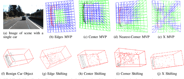
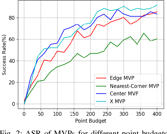
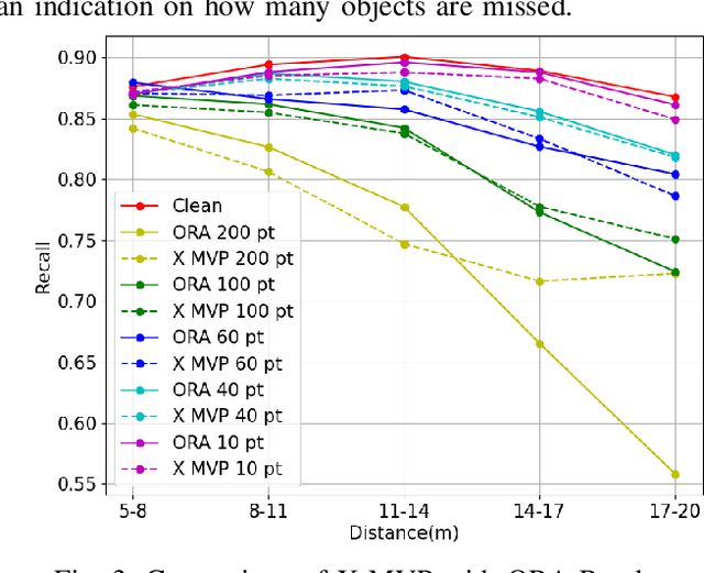
Abstract:LiDAR sensors are widely used in autonomous vehicles to better perceive the environment. However, prior works have shown that LiDAR signals can be spoofed to hide real objects from 3D object detectors. This study explores the feasibility of reducing the required spoofing area through a novel object-hiding strategy based on virtual patches (VPs). We first manually design VPs (MVPs) and show that VP-focused attacks can achieve similar success rates with prior work but with a fraction of the required spoofing area. Then we design a framework Saliency-LiDAR (SALL), which can identify critical regions for LiDAR objects using Integrated Gradients. VPs crafted on critical regions (CVPs) reduce object detection recall by at least 15% compared to our baseline with an approximate 50% reduction in the spoofing area for vehicles of average size.
GUing: A Mobile GUI Search Engine using a Vision-Language Model
Apr 30, 2024


Abstract:App developers use the Graphical User Interface (GUI) of other apps as an important source of inspiration to design and improve their own apps. In recent years, research suggested various approaches to retrieve GUI designs that fit a certain text query from screenshot datasets acquired through automated GUI exploration. However, such text-to-GUI retrieval approaches only leverage the textual information of the GUI elements in the screenshots, neglecting visual information such as icons or background images. In addition, the retrieved screenshots are not steered by app developers and often lack important app features, e.g. whose UI pages require user authentication. To overcome these limitations, this paper proposes GUing, a GUI search engine based on a vision-language model called UIClip, which we trained specifically for the app GUI domain. For this, we first collected app introduction images from Google Play, which usually display the most representative screenshots selected and often captioned (i.e. labeled) by app vendors. Then, we developed an automated pipeline to classify, crop, and extract the captions from these images. This finally results in a large dataset which we share with this paper: including 303k app screenshots, out of which 135k have captions. We used this dataset to train a novel vision-language model, which is, to the best of our knowledge, the first of its kind in GUI retrieval. We evaluated our approach on various datasets from related work and in manual experiment. The results demonstrate that our model outperforms previous approaches in text-to-GUI retrieval achieving a Recall@10 of up to 0.69 and a HIT@10 of 0.91. We also explored the performance of UIClip for other GUI tasks including GUI classification and Sketch-to-GUI retrieval with encouraging results.
Identifying Optimal Launch Sites of High-Altitude Latex-Balloons using Bayesian Optimisation for the Task of Station-Keeping
Mar 16, 2024


Abstract:Station-keeping tasks for high-altitude balloons show promise in areas such as ecological surveys, atmospheric analysis, and communication relays. However, identifying the optimal time and position to launch a latex high-altitude balloon is still a challenging and multifaceted problem. For example, tasks such as forest fire tracking place geometric constraints on the launch location of the balloon. Furthermore, identifying the most optimal location also heavily depends on atmospheric conditions. We first illustrate how reinforcement learning-based controllers, frequently used for station-keeping tasks, can exploit the environment. This exploitation can degrade performance on unseen weather patterns and affect station-keeping performance when identifying an optimal launch configuration. Valuing all states equally in the region, the agent exploits the region's geometry by flying near the edge, leading to risky behaviours. We propose a modification which compensates for this exploitation and finds this leads to, on average, higher steps within the target region on unseen data. Then, we illustrate how Bayesian Optimisation (BO) can identify the optimal launch location to perform station-keeping tasks, maximising the expected undiscounted return from a given rollout. We show BO can find this launch location in fewer steps compared to other optimisation methods. Results indicate that, surprisingly, the most optimal location to launch from is not commonly within the target region. Please find further information about our project at https://sites.google.com/view/bo-lauch-balloon/.
FuncGrasp: Learning Object-Centric Neural Grasp Functions from Single Annotated Example Object
Feb 22, 2024Abstract:We present FuncGrasp, a framework that can infer dense yet reliable grasp configurations for unseen objects using one annotated object and single-view RGB-D observation via categorical priors. Unlike previous works that only transfer a set of grasp poses, FuncGrasp aims to transfer infinite configurations parameterized by an object-centric continuous grasp function across varying instances. To ease the transfer process, we propose Neural Surface Grasping Fields (NSGF), an effective neural representation defined on the surface to densely encode grasp configurations. Further, we exploit function-to-function transfer using sphere primitives to establish semantically meaningful categorical correspondences, which are learned in an unsupervised fashion without any expert knowledge. We showcase the effectiveness through extensive experiments in both simulators and the real world. Remarkably, our framework significantly outperforms several strong baseline methods in terms of density and reliability for generated grasps.
NeRF-VO: Real-Time Sparse Visual Odometry with Neural Radiance Fields
Dec 20, 2023


Abstract:We introduce a novel monocular visual odometry (VO) system, NeRF-VO, that integrates learning-based sparse visual odometry for low-latency camera tracking and a neural radiance scene representation for sophisticated dense reconstruction and novel view synthesis. Our system initializes camera poses using sparse visual odometry and obtains view-dependent dense geometry priors from a monocular depth prediction network. We harmonize the scale of poses and dense geometry, treating them as supervisory cues to train a neural implicit scene representation. NeRF-VO demonstrates exceptional performance in both photometric and geometric fidelity of the scene representation by jointly optimizing a sliding window of keyframed poses and the underlying dense geometry, which is accomplished through training the radiance field with volume rendering. We surpass state-of-the-art methods in pose estimation accuracy, novel view synthesis fidelity, and dense reconstruction quality across a variety of synthetic and real-world datasets, while achieving a higher camera tracking frequency and consuming less GPU memory.
 Add to Chrome
 Add to Firefox
 Add to Edge