Mihir Dharmadhikari
Collaborative Exploration with a Marsupial Ground-Aerial Robot Team through Task-Driven Map Compression
Sep 09, 2025


Abstract:Efficient exploration of unknown environments is crucial for autonomous robots, especially in confined and large-scale scenarios with limited communication. To address this challenge, we propose a collaborative exploration framework for a marsupial ground-aerial robot team that leverages the complementary capabilities of both platforms. The framework employs a graph-based path planning algorithm to guide exploration and deploy the aerial robot in areas where its expected gain significantly exceeds that of the ground robot, such as large open spaces or regions inaccessible to the ground platform, thereby maximizing coverage and efficiency. To facilitate large-scale spatial information sharing, we introduce a bandwidth-efficient, task-driven map compression strategy. This method enables each robot to reconstruct resolution-specific volumetric maps while preserving exploration-critical details, even at high compression rates. By selectively compressing and sharing key data, communication overhead is minimized, ensuring effective map integration for collaborative path planning. Simulation and real-world experiments validate the proposed approach, demonstrating its effectiveness in improving exploration efficiency while significantly reducing data transmission.
Semantics-aware Predictive Inspection Path Planning
Jun 06, 2025Abstract:This paper presents a novel semantics-aware inspection path planning paradigm called "Semantics-aware Predictive Planning" (SPP). Industrial environments that require the inspection of specific objects or structures (called "semantics"), such as ballast water tanks inside ships, often present structured and repetitive spatial arrangements of the semantics of interest. Motivated by this, we first contribute an algorithm that identifies spatially repeating patterns of semantics - exact or inexact - in a semantic scene graph representation and makes predictions about the evolution of the graph in the unseen parts of the environment using these patterns. Furthermore, two inspection path planning strategies, tailored to ballast water tank inspection, that exploit these predictions are proposed. To assess the performance of the novel predictive planning paradigm, both simulation and experimental evaluations are performed. First, we conduct a simulation study comparing the method against relevant state-of-the-art techniques and further present tests showing its ability to handle imperfect patterns. Second, we deploy our method onboard a collision-tolerant aerial robot operating inside the ballast tanks of two real ships. The results, both in simulation and field experiments, demonstrate significant improvement over the state-of-the-art in terms of inspection time while maintaining equal or better semantic surface coverage. A set of videos describing the different parts of the method and the field deployments is available at https://tinyurl.com/spp-videos. The code for this work is made available at https://github.com/ntnu-arl/predictive_planning_ros.
Maritime Vessel Tank Inspection using Aerial Robots: Experience from the field and dataset release
Apr 29, 2024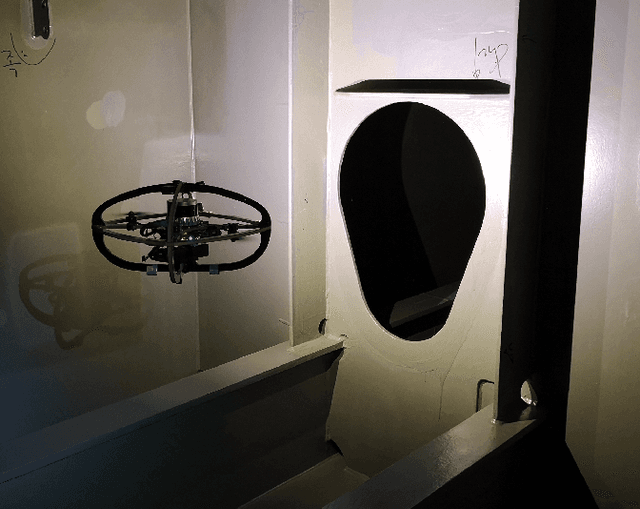
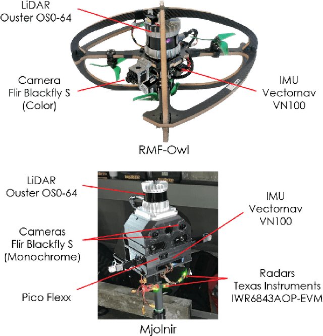
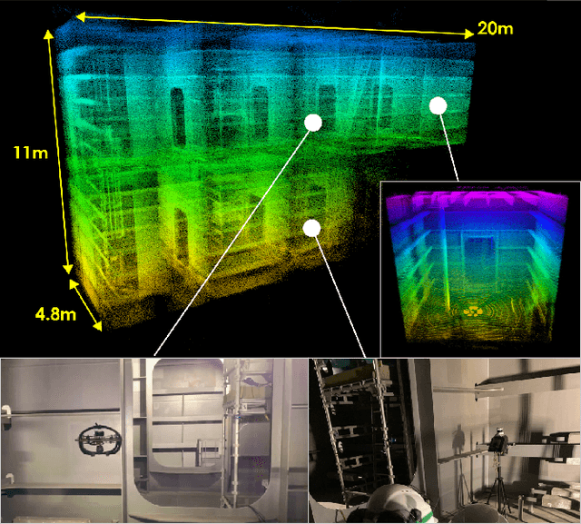
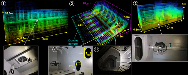
Abstract:This paper presents field results and lessons learned from the deployment of aerial robots inside ship ballast tanks. Vessel tanks including ballast tanks and cargo holds present dark, dusty environments having simultaneously very narrow openings and wide open spaces that create several challenges for autonomous navigation and inspection operations. We present a system for vessel tank inspection using an aerial robot along with its autonomy modules. We show the results of autonomous exploration and visual inspection in 3 ships spanning across 7 distinct types of sections of the ballast tanks. Additionally, we comment on the lessons learned from the field and possible directions for future work. Finally, we release a dataset consisting of the data from these missions along with data collected with a handheld sensor stick.
Autonomous Exploration and General Visual Inspection of Ship Ballast Water Tanks using Aerial Robots
Nov 07, 2023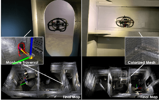

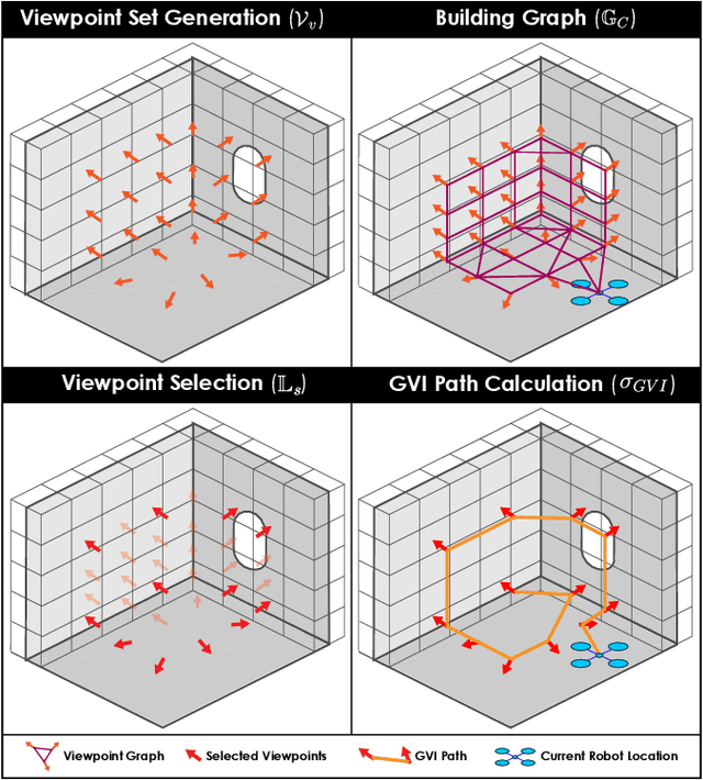
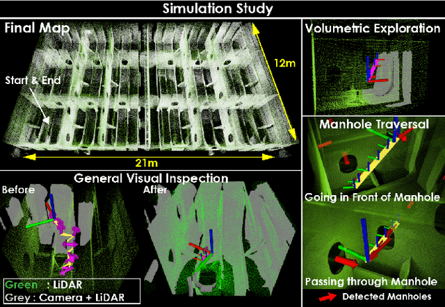
Abstract:This paper presents a solution for the autonomous exploration and inspection of Ballast Water Tanks (BWTs) of marine vessels using aerial robots. Ballast tank compartments are critical for a vessel's safety and correspond to confined environments often connected through particularly narrow manholes. The method enables their volumetric exploration combined with visual inspection subject to constraints regarding the viewing distance from a surface. We present evaluation studies in simulation, in a mission consisting of 18 BWT compartments, and in 3 field experiments inside real vessels. The data from one of the experiments is also post-processed to generate semantically-segmented meshes of inspection-important geometries. Geometric models can be associated with onboard camera images for detailed and intuitive analysis.
An Online Self-calibrating Refractive Camera Model with Application to Underwater Odometry
Oct 25, 2023Abstract:This work presents a camera model for refractive media such as water and its application in underwater visual-inertial odometry. The model is self-calibrating in real-time and is free of known correspondences or calibration targets. It is separable as a distortion model (dependent on refractive index $n$ and radial pixel coordinate) and a virtual pinhole model (as a function of $n$). We derive the self-calibration formulation leveraging epipolar constraints to estimate the refractive index and subsequently correct for distortion. Through experimental studies using an underwater robot integrating cameras and inertial sensing, the model is validated regarding the accurate estimation of the refractive index and its benefits for robust odometry estimation in an extended envelope of conditions. Lastly, we show the transition between media and the estimation of the varying refractive index online, thus allowing computer vision tasks across refractive media.
Semantics-aware Exploration and Inspection Path Planning
Mar 13, 2023Abstract:This paper contributes a novel strategy for semantics-aware autonomous exploration and inspection path planning. Attuned to the fact that environments that need to be explored often involve a sparse set of semantic entities of particular interest, the proposed method offers volumetric exploration combined with two new planning behaviors that together ensure that a complete mesh model is reconstructed for each semantic, while its surfaces are observed at appropriate resolution and through suitable viewing angles. Evaluated in extensive simulation studies and experimental results using a flying robot, the planner delivers efficient combined exploration and high-fidelity inspection planning that is focused on the semantics of interest. Comparisons against relevant methods of the state-of-the-art are further presented.
Team CERBERUS Wins the DARPA Subterranean Challenge: Technical Overview and Lessons Learned
Jul 11, 2022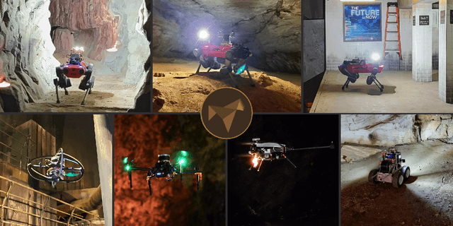
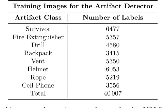
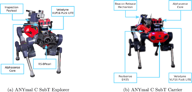
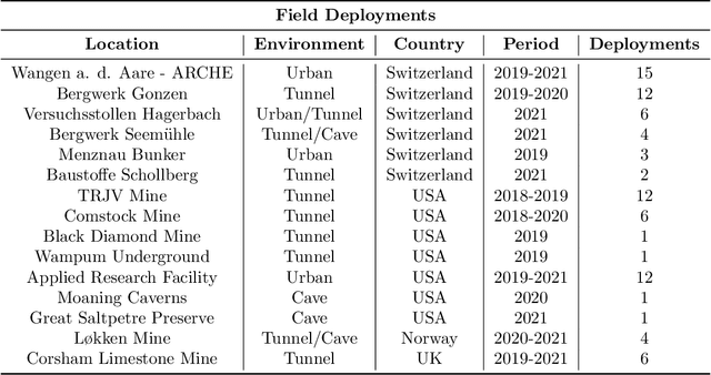
Abstract:This article presents the CERBERUS robotic system-of-systems, which won the DARPA Subterranean Challenge Final Event in 2021. The Subterranean Challenge was organized by DARPA with the vision to facilitate the novel technologies necessary to reliably explore diverse underground environments despite the grueling challenges they present for robotic autonomy. Due to their geometric complexity, degraded perceptual conditions combined with lack of GPS support, austere navigation conditions, and denied communications, subterranean settings render autonomous operations particularly demanding. In response to this challenge, we developed the CERBERUS system which exploits the synergy of legged and flying robots, coupled with robust control especially for overcoming perilous terrain, multi-modal and multi-robot perception for localization and mapping in conditions of sensor degradation, and resilient autonomy through unified exploration path planning and local motion planning that reflects robot-specific limitations. Based on its ability to explore diverse underground environments and its high-level command and control by a single human supervisor, CERBERUS demonstrated efficient exploration, reliable detection of objects of interest, and accurate mapping. In this article, we report results from both the preliminary runs and the final Prize Round of the DARPA Subterranean Challenge, and discuss highlights and challenges faced, alongside lessons learned for the benefit of the community.
Marsupial Walking-and-Flying Robotic Deployment for Collaborative Exploration of Unknown Environments
May 11, 2022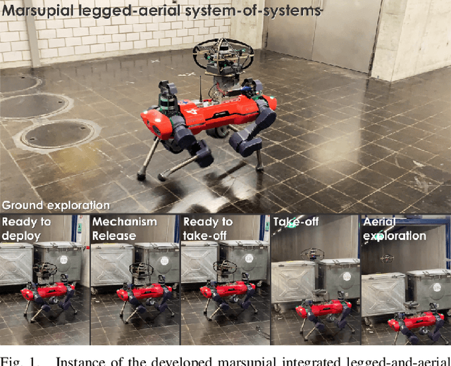
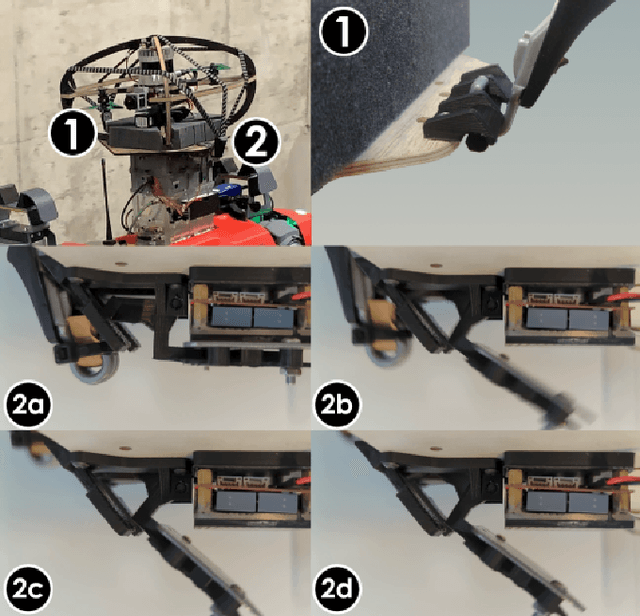
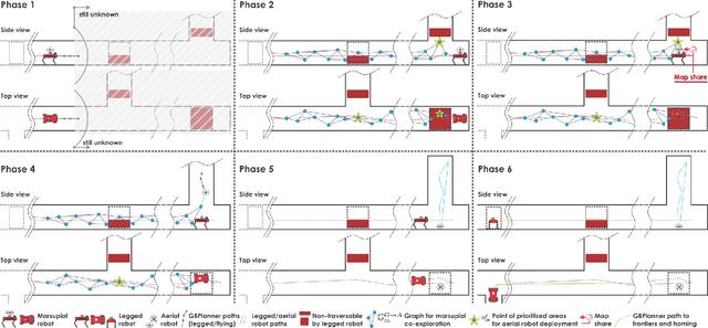
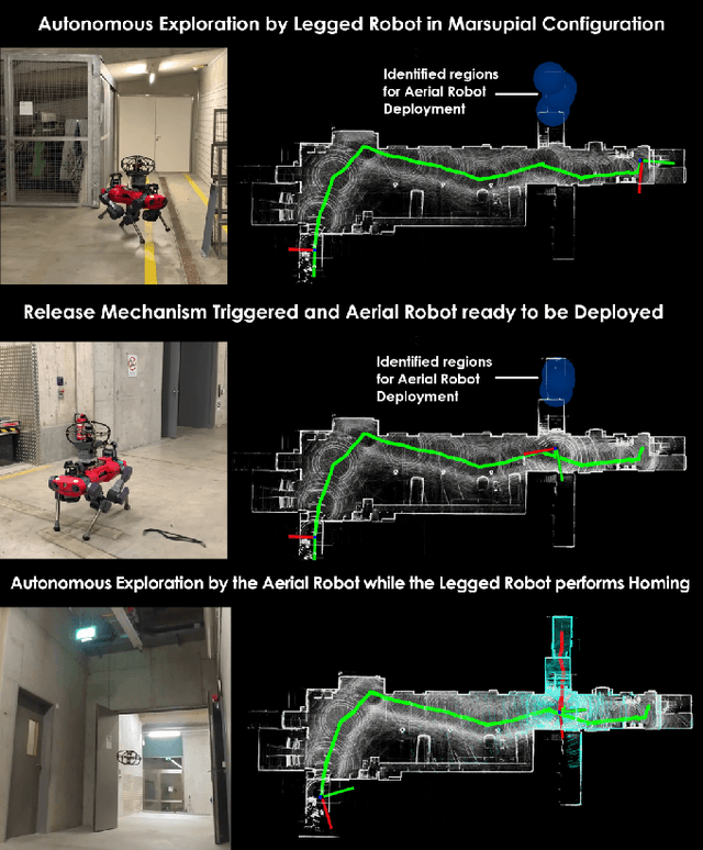
Abstract:This work contributes a marsupial robotic system-of-systems involving a legged and an aerial robot capable of collaborative mapping and exploration path planning that exploits the heterogeneous properties of the two systems and the ability to selectively deploy the aerial system from the ground robot. Exploiting the dexterous locomotion capabilities and long endurance of quadruped robots, the marsupial combination can explore within large-scale and confined environments involving rough terrain. However, as certain types of terrain or vertical geometries can render any ground system unable to continue its exploration, the marsupial system can - when needed - deploy the flying robot which, by exploiting its 3D navigation capabilities, can undertake a focused exploration task within its endurance limitations. Focusing on autonomy, the two systems can co-localize and map together by sharing LiDAR-based maps and plan exploration paths individually, while a tailored graph search onboard the legged robot allows it to identify where and when the ferried aerial platform should be deployed. The system is verified within multiple experimental studies demonstrating the expanded exploration capabilities of the marsupial system-of-systems and facilitating the exploration of otherwise individually unreachable areas.
RMF-Owl: A Collision-Tolerant Flying Robot for Autonomous Subterranean Exploration
Feb 22, 2022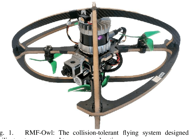
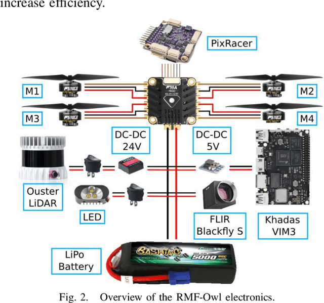
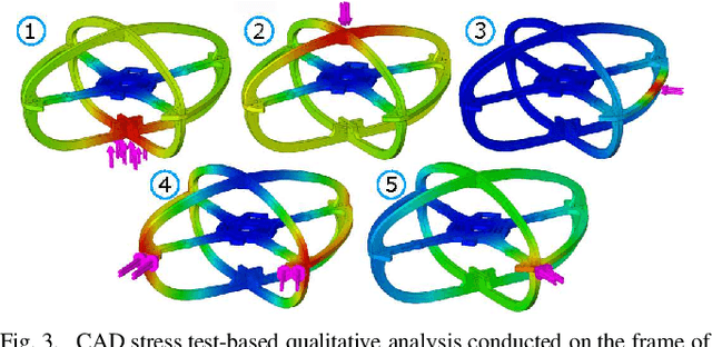
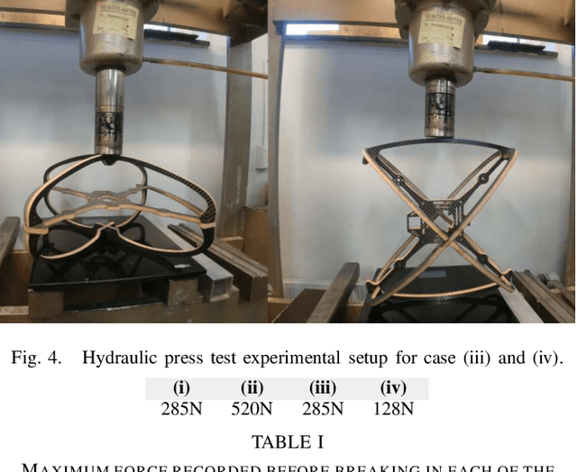
Abstract:This work presents the design, hardware realization, autonomous exploration and object detection capabilities of RMF-Owl, a new collision-tolerant aerial robot tailored for resilient autonomous subterranean exploration. The system is custom built for underground exploration with focus on collision tolerance, resilient autonomy with robust localization and mapping, alongside high-performance exploration path planning in confined, obstacle-filled and topologically complex underground environments. Moreover, RMF-Owl offers the ability to search, detect and locate objects of interest which can be particularly useful in search and rescue missions. A series of results from field experiments are presented in order to demonstrate the system's ability to autonomously explore challenging unknown underground environments.
CERBERUS: Autonomous Legged and Aerial Robotic Exploration in the Tunnel and Urban Circuits of the DARPA Subterranean Challenge
Jan 18, 2022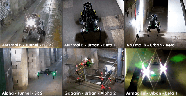

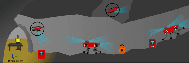

Abstract:Autonomous exploration of subterranean environments constitutes a major frontier for robotic systems as underground settings present key challenges that can render robot autonomy hard to achieve. This has motivated the DARPA Subterranean Challenge, where teams of robots search for objects of interest in various underground environments. In response, the CERBERUS system-of-systems is presented as a unified strategy towards subterranean exploration using legged and flying robots. As primary robots, ANYmal quadruped systems are deployed considering their endurance and potential to traverse challenging terrain. For aerial robots, both conventional and collision-tolerant multirotors are utilized to explore spaces too narrow or otherwise unreachable by ground systems. Anticipating degraded sensing conditions, a complementary multi-modal sensor fusion approach utilizing camera, LiDAR, and inertial data for resilient robot pose estimation is proposed. Individual robot pose estimates are refined by a centralized multi-robot map optimization approach to improve the reported location accuracy of detected objects of interest in the DARPA-defined coordinate frame. Furthermore, a unified exploration path planning policy is presented to facilitate the autonomous operation of both legged and aerial robots in complex underground networks. Finally, to enable communication between the robots and the base station, CERBERUS utilizes a ground rover with a high-gain antenna and an optical fiber connection to the base station, alongside breadcrumbing of wireless nodes by our legged robots. We report results from the CERBERUS system-of-systems deployment at the DARPA Subterranean Challenge Tunnel and Urban Circuits, along with the current limitations and the lessons learned for the benefit of the community.
 Add to Chrome
 Add to Firefox
 Add to Edge